|
Home Page
Discovery of Atlantis
First Empire-(1) to 261
Second Empire- (1) 361 - 409 |
| A Description of the Atlantean Empire
LASSO NAHUSSE, THAISON BOURBRONNA AND FELLA THULPAS The purpose of this Interlude is to give a brief description of the main areas of the Atlantean Empire, as much from the social point of view as from a description of the natural features of the landscape. Throughout the epochs, men and women travelled throughout the Empire, and sometimes beyond its borders, purely out of personal interest, though often also in order to write of their experiences. A record of these travellers’ reports begins for us in the Second Empire, in 456, but the most renowned account was produced by Lasso Nahusse in 552.Nahusse, who worked for the Provincial Government of Atlantis, was well-known for his love of travel and interest in Atlantean antiquities. He was dispatched by the Emperor Crehonerex I in 542 in order to produce a comprehensive and up-to-date account of the "state of the Empire for the edification of men who governed". He was also to write about more sensitive, political matters for the eyes of the Emperor only – this section was never published. He travelled for five years along the major roads from Atlantis, north to Eliossie, east to the borders of Ughrieh, and south to Helvrieh and Manralia. By the time he returned to Atlantis, Crehonerex II was in power. Nahusse produced his account in 552, and when printing was permitted in the Empire some decades later, it became a best-seller, and the most famous of all Second Empire travellers’ reports, though written in the third person, as was traditional in this period. So far as this Interlude is concerned, however, the bulk of the story will belong to a writer of the Third Empire, Thaison Bourbronna. Bourbronna was a prosperous and independent Squire from Chalcrieh (as his name suggests), who was fascinated by history, and looked upon Nahusse as his model. By this period it was common for Squires and their families, as well as younger sons with their tutors, to travel round the Empire as part of their education (rather like the eighteenth century "Grand Tour" in Europe). Bourbronna frequently compared his experiences with the earlier writer, and in the extracts to follow, we shall from time to time use Nahusse’s account to cover areas or matters missed by Bourbronna. The latter travelled between 708 and 713 on four expeditions, all starting in Cennatlantis. Like his predecessor, he moved along main roads for most of the time, but was more willing to take diversions into the countryside to visit places of interest. He went to Atlantis and north to Eliossie; east and south-east through the Keltish lands; up the east of the Chalcran Lakes to Runnates and on to the river Gestes, and south down it. He also travelled south-east to Razira, and from Atlantis south across the Helvengio and down the Coastal City States. He wrote up and published his account as a personal travelogue after 716, and it became one of the most popular travel books of the period. During the Fourth Empire, travelling through the Empire became much more common for everyone, and a real tourist trade began. Travel writers moved deliberately off the beaten track – the main roads and well-known cities and landmarks-, and also travelled more frequently to foreign countries and across the seas. Traditional travel-writing about places within the Empire saw something of a resurgence after the 830s, as writers concentrated on the history of certain areas throughout the Empire and earlier. But the great growth in urbanistion and industrialisation, as well as the spread of railways, had in fact altered the landscape for ever, and many places were, by the 800s, very different to what they had appeared when earlier travellers had seen them. Furthermore, great wars (such as the Continental War), and upheavals (as the time of the Tyrants), had left their own new legacy of battlefields to visit, and monuments to admire, as well as the destruction of buildings and earlier sites of interest. Fella Thulpas, who travelled across the Empire between 852 and 855, aimed to cover both the historical importance of and changes to a series of sites, as well as to describe the great changes wrought elsewhere by industry over the past century. Fella Thulpas was of course a woman, and had been married to a businessman until his early death at the age of 45. She had already written a few books, both fiction and history, but now decided to seize her opportunity, travel the Empire, and write it all up afterwards. Her great book, finally published in 861, was both an accurate historically slanted description of a specific number of places throughout the Empire, and an impressionistic account of her experiences throughout her travels. She travelled in a great circle from Atlantis, first to Numidis and east along the Helvran coast to Vailat. Then, a bit later, back to Cennatlantis and up the west of the Lakes to Buresso. Finally she moved north into Kelt lands, now part of Skallandieh, which had only recently been at war with Atlantis. She moved west into Marossan, went down the length of Yciel Atlantis and finally returned to Atlantis by sea. We shall make use of Thulpas’ writings as additions to the central core of Bourbronna’s, to describe developments which took place after the time of the Third Empire. After Thulpas herself, there is little more to tell. Travel of any sort virtually ceased after 870, when the Final Wars began, and fighting thereafter preoccupied all Atlanteans until the end of the Empire twenty years later. There now follow the words of the travellers themselves. The passages below are mere extracts from their writings, which have been joined together by the editor, without indicating passages omitted, to make a short description of as much of the Empire as possible. All the words are original, unless otherwise noted. THE ROAD WEST: THE YELTRATA AND CENNRATA "The Yeltrata ("Old Road") extends all the way from Cennatlantis to Atlantis, via Gentes, the Lillerunix and Yeldis; I, however, moved off this road at Gentes, travelled north on the road alongside the river Rollepp, and joined the Cennrata to Atlantis at Ancahouth. This was partly because my great predecessor, Nahusse, has already told his tale of the Yeltrata, but did not mention the Cennrata. The road travels westwards, initially within a very constricted landscape, with rivers to north and south, and the foothills of the Meilox Mountains frowning to the south-west. The whole area up to the river Rollepp was of course originally divided up into the little city-states of the Atlantids, and even now it strikes the traveller as having a different character to the original Atlantean lands. It is, though, thoroughly "Atlanticised" now, and all trace of the old Atlantis dialect seems to have disappeared – though Nahusse states that in his time, it was still to be heard in country areas. It is a largely pastoral landscape around Failbloua and Yalgor, full of gently rolling downs, sheep and cattle, and villages which were once, 500 years ago, proud and independent towns. "The biggest towns now are all on the Rollepp – Gentes, Tilrase and Ancahouth: the first two being "closed cities".[ Ruthopheax I’s decree walling in cities which had been Republican supporters].... Much of the open land both east and west of Tilrase was landscaped by the great men of the Second Empire for entertainments – theatrical performances in the countryside. Such plays and musical festivals are frequently mentioned by Nahusse, and it is a pity that they ceased after the Revolution and have never been taken up again. Nowadays we have the Squires’ hunting courses, which require different sorts of landscapes. These cover vast distances, and are designed for ease of chasing and hunting, rather than for artistic effect. There has to be plenty of areas which are suitable for the animals which are being chased; this included human criminals, as well, up till very recently. "As I move north from Tilrase, around which much industry seems to be clustering, the land grows becomes more hemmed in, hillier and more afforested. At Ancahouth, I join the "Cennrata" to Atlantis via Fourtis: this is the oldest road which connect Atlantis and Atlantidieh with the Chalcran states. The part of the Province of Atlantis between the rivers Rollepp and Bore was formerly thickly wooded, and even now the large woods of the Borfembe ("Large wood") in the north, and the "Failfembe" ("Green wood") to the south survive. ( Nahusse: These woods, stretching for miles from the east bank of the Bore, were once seen as dark and sinister places, and many religious stories and children’s fairy-tales, have these forests as their background. In fact, some of the stories are completely pagan, and in the early years of the last Empire, the priests of the Official Religion saw it as their duty to counteract the influence of these tales. They did this by felling great circles in the woods, and in these clearings, built open-air or constructed churches. In other places, they set up statues of the great heroes of the Religion to cast their beneficent aura over the dark woods all around. Many of these figures remain as interesting examples of the faith and credulity of our forefathers). (Thulpas: Fourtis and the "Borfembe" is the site of two of the most significant battles of Atlantean history. The Battle of Fourtis, in 588, witnessed the rout of the Imperialist forces under General Lingon by the rebels (later the Republicans), while in 746, the Atlantean Army held off and decisively beat the Skalland invasion of Atlantis at the Battle of the Borfembe. The magnificent monument to this battle stands on the strategic hill overlooking the town of Duiccul on the river Ghesse.) "Crossing the Bore at Fourtis, the "Cennrata" runs straight south-westwards to Atlantis, through Failrun and across the little river Puster. All this area is the heartland of Atlantis, indeed of that region traditionally called North Atlantis, and which is contrasted with the rest of The Province. It is claimed that before the days of the Empire, the "southern" Atlanteans conquered the city of Atlantis and this whole northern area, and forced on them their rule and their speech, which is essentially our present-day language. As I have already mentioned with regard to the dialect of the Atlantids, some 300 years, a distinctive North Atlantean dialect was still spoken in these parts, at least in country areas, but this has now completely died out. "We now approach the city of Atlantis, and without actually entering it, I shall move on to the "Atlanrata", which goes north from the city. THE ROAD NORTH: THE ATLANRATA AND MAROSSARAITA "This great road, the "Atlanrata", first constructed and extended in the third century goes northwards via Sulosis to Ghestis, and southwards via Ygohe as far as Celinge. It is called a "rata", like the Cennrata going eastwards, but this in the older language meant "road", rather than just "way", as now. In more recent roads, we find the word "raita", as in the Raziraraita and the Marossaraita. Leaving the city, I passed the former estates of the great noblemen of the First and early Second Empires. These were broken up by the Republicans after the Revolution, and many were divided up amongst the lower Classes. Some mansions survive, but no noblemen of this Empire would wish to live so close to Atlantis out of choice. However, the great Palace built by Atlaniphon III, which lies a little way east of our road, some eight miles out of the city, is now occupied by the Provincial Government of Yeldatlantis. (Thulpas adds: (Here) there stands the great monument to the victory of the Atlanteans over the invading army of the Skallands at the Battle of Atlantis on June 5th, 746. This was the nearest any foreign army had ever come to the city of Atlantis, not excepting the Helvran War.) "Our road skirts the seaward flank of the Huainarun, the "heavenly hills", and arrives at the great port of Sulosis. This has been the main base of our navy in this area since the Emperor Ruthopheax I. It is very different now to the small fishing and passenger terminus described by Nahusse 170 years ago. The road now turns east to cross the river Bore. This is a wide and fast-flowing waterway where it enters the sea, and the first main bridge over it is at Ghestis, 35 miles inland. As I approached this town, I could see to my right the hills and woods of the Pusseal ("Little wood"). In olden days, this was thick and impenetrable, and the subject of many ghostly folktales, but some of it has now been felled for shipbuilding. (Thulpas: Both the Pusseal and the Borfembe (woods) are now but sad skeletons of their former glory. The wood needed for industry and shipbuilding has been ruthlessly stripped from these forests. I have not seen the Pusseal myself, but I know that what Bourbronna described as already beginning in his time, has now gone so far as to reduce it to two or three small plantations.) Ghestis is relatively small town, but famous for having the oldest university in the Empire .It existed as a place of learning for noblemen before the foundation of the First Empire, and Emperor Carel I named it the Imperial University. Since the fall of the second Empire, it has lost the noble "cachet" it once had, and is now a centre for scholars from all over the Empire. "Across the river Bore, the road changes to the "Marossaraita", which was built in the fourth century to link up with the newly acquired Marossan Provinces. Between the rivers Bore and Noilafa (also called the Rollepp further south in Atlantean parts), the landscape is open and hilly. The road keeps well away from the coast, which here is mostly precipitously steep, with great cliffs towering over the ocean. The traditional border with our Province of Marossan crossed these hills midway between the two rivers, but since the victories of the great Ruthopheax, the border has been pushed back north to the Noilafa, on the other side of which is the state of Anauren. At present this country is on reasonably friendly terms with Atlantis, and I shall pass through this area, which recently and for so long was one of our Provinces, in order to reach Yciel Atlantis. "Just south of the border, another road branches off to the right, the "Marossayaita", which takes you to Anetako ("yaita" is of course the Marossan word for "road", our "raita"). Over the Noilafa, the Marossaraita goes back to the coast, the Marossa Liranca, and hugs it northwards over the river Sulophaio to Leiyola, the old Provincial capital, and also the capital city of Anauren. To my right, throughout this part of the journey, I can see the tall peaks of the Netaka Mountains and the Noilafamona, which completely cut off the inner part of the Province (as was). Though not exceptionally high, some parts are often covered in snow; the only way through them is via one or two passes – the Netaka and Noilafa Buoumix. As may be imagined, these were of great strategic importance to armies in the distant past, and were held against the nomadic invaders as recently as the early part of the last century. (Thulpas: Bourbronna speaks naively of the mountains and passes of Anauren/Marossan being strategic points in the distant past; how could he have known of the bitter fighting which was to take place against the Skallands in this area within a few years of his death in 741, and again just a few years ago in the Great Northern War.) "This whole area around Leiyola is rich in antiquities and remains of the great Marossan Empire, which flourished here many centuries ago. The road to Leiyola is fringed with broken stone ruins, and outside the present city of Leiyola, are the vast remnants of the old Marossan capital, surrounded by a city-wall still over 20 feet high in parts. Ruinous though it is, it still instills a feeling of awe, with its massive block-like structures, of every geometrical style imaginable. This contrasts vividly with the typical building-style of the more recent Lio-Marossans and Phonerians, who have always constructed in cool, rectangular, neat shapes, using stone columns and pillars. Modern Leiyola has long been a city of scholarship, as well as a port. The port seems to be being greatly enlarged at present, although I was not allowed to visit parts of it. (Thulpas: The port of Leiyola became the base for the great Anauren navy of the Continental War. The whole lower reaches of the river Sulophaio were to be dedicated to shipbuilding in this period, and of course more recently the whole area has become a tremendous industrial basin, for ironworking, shipbuilding and textile-making.) "The Marossaraita continues right up to the border with our Province of Yciel Atlantis, and thanks to my documents from the government at Cennatlantis, and the friendship between our two countries, in the face of the threats by the Skallands, I was able to cross directly into Yciel Atlantis. I marvelled at the Upheril Mountains, and our forts along it, which have ever provided such a wonderful natural defence of this peninsula from any would-be invader. The road crawls along the north coast here, round the edge of the foothills. It then wanders to and fro across this rocky land, and I pass in turn through Uphorolo, Nerilo, Atalaso, Nundler and Phonero. These little towns, all built on original Phonerian foundations, are in some ways hardly "Atlanticised" at all. Most of them are on the coast, and gain their livelihood from the sea – the Phonerians continue their long tradition of fishing and trading on the ocean. At the western end of this strangely shaped piece of land, the land becomes much flatter and more liable to flooding, and great lakes lie scattered across its interior. The great bay across which Yciel Atlantis stretches like an arm and a hand with fingers flexed, the Marossa Liranca, is full of islands, and nowhere do they cluster so closely to the land than south and east of Phonero, and the port and naval base of Achosil, on its own island. I was able to stand on the land opposite Achosil, just a few miles to the north, and watch the great sailing-ships of our navy manoeuvering in and around these "Achosil Mandengix".
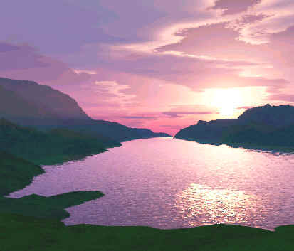
View of one of the lakes in the Yciel Atlantis peninsula at sunset.
"To the west, there is another, slightly less narrow channel, the "Phonerianix Lirilix", across which I had to sail to reach the huge island of Phonaria. It really feels like the end of the world, when you arrive here. It has what seems like just a thin veneer of Atlantean civilisation – a few towns and villages, connected by rather primitive roads. I travelled west across the river Snazuephue to Netherpand. Beyond that our dominion peters out, with a final series of lookouts and forts on the massive mountain of Suchamoundo. This whole part of the island lives from pastoral pursuits, cattle and sheep, and fish from the seas. Wood is also gathered from the great forests of the interior, and silver and precious metals can also be mined here. The language and names of the geographical features in this further part of Phonaria are strange, though also pleasing, to our ears, but with no connection to our own tongues. I was told of the towns of Nanosto and Anarost to the north and south, and the mountain of Aihoroto to the north-west. I had come to the end of my northern journey, on the extremity of empire. It was now time for me to return to Anauren, and continue my journey back to Cennatlantis via a long diversion through the Keltish lands. (Thulpas: This western part of Phonaria was earlier under the influence of Quendelie, and the language here was Quendelien. Quendelie later directly took over this area, and eventually the whole of Phonaria, with the consent of Atlantis). THE ROAD NORTH-EAST: THE LANDS OF THE KELTS I begin this new part of my travels by returning to the junction of the Marossaraita and the Marossayaita, south of the river Noilafa. I set off north-eastwards on this road, built largely on the basis of a Lio-Marossan road. In fact it was originally laid down centuries ago by that mysterious Marossan Empire which stretched across the territories of present-day Anauren, the Kelts and much of the centre of the Atlantean Empire. As I move further eastwards I shall also see many impressive ruins from this distant past. After recrossing the river Noilafa, the land grows much hillier, and the Netaka Mountains come into view ahead. The Marossayaita goes through the Noilafa Pass, at the centre of which is the town of Latala. Beyond this pass, the land becomes flatter again, and I enter what is really a vast plain, which is almost completely surrounded by geographical obstacles. To the north and east is the river Ruphaio, as well as the Cresskor and Gedandolix mountains; to the south is the Decanda Runix, separating us here from Atlantis and Atlantidieh; and to the west are the Netaka Mountains, which I have just crossed. However, this plain is by no means flat, and contains many areas of low hills and downs.
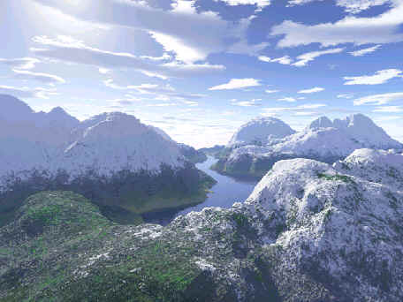
The river Ruphaio in the Cresskor Mountains
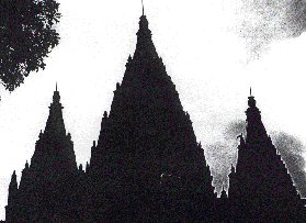
After about sixty miles, I reach Runcairn, which is at the junction of the Marossayaita and another road which passes southwards through the Decanda Runix to Ancahouth, and northwards to Marossulo on the Ruphaio. Another sixty miles or so takes me to Cairtan, the capital of the Province of "Naokeltanieh", and the edges of the great Cresskor Mountains. As the names of the towns and geographical features from here onwards indicate, I am now entering lands long inhabited by the Kelts, specifically here the West Kelts. We may note the frequent occurrence of the word "tan", meaning "town", of "cairn" meaning "hill", or "dun", which is a "mountain pass". It is only really as I travel through the Cressdun pass in the Cresskor Mountains, that the landscape and towns and villages appear fully Keltish, and I hear this ancient language being spoken all around me. The Kelts themselves traditionally built using wood, and in the more remote towns and the villages, these wooden buildings are everywhere to be seen, all ornamented with fanciful shapes and designs. Elsewhere, too, the landscape is dotted with their strange, tribal and religious symbols. Many of these are of stone, and consist of great pillars or "menhirs", and sometimes of huge altars of stone, where they sometimes still congregate to practice their mysterious religion, each village led by its priest, or "Taigor". The Kelts are also great miners, and many a pintur (or mine) was visible during my travels hereabouts. But intermingled with these relatively modern remains are those of the ancient Marossans, with their vast geometrical stone ruins, and also their paved roads, now usually overgrown and broken up, and seeming to run from nowhere to nowhere. My "Marossayaita" strictly ended at Cairtan, but the road I am now following through the mountains to Keltanipand, though rebuilt by our own Emperors, is in parts on a Marossan basis, and is usually also called the "Marossayaita". When I have passed through the Cresskor Ugholix, I reach the town of Mountan, set in the middle of the lower land between the Cresskor to the west, and the great mountain ranges of the North Kelts to the north-east, the Dorkor and the Dachdol. Keltanipand is the military garrison town of this whole region, and is completely new, by which I mean it was built only about 300 years ago during the Second Empire. This area is populated by North Kelts, but the main region for this people is to the north, in the even more mountainous area of the Nundor, and the towns of Caddis, Keltanis and Tar-ar-Dun. This was promised to the Kelts as an independent and self-governing area by Ruthopheax I, with which neither the Atlanteans nor any other nation would interfere, although it was once part of our Empire. However, over the past few years, reports have reached us that army units of both Skallandieh and Gestskallandieh have entered this area. I have been able to partially verify this myself, as my request to visit at least Keltanis was rejected by the military authorities here in Keltanipand. They have told me that their intelligence has proved that the Skallands now occupy this area, and it would be much too dangerous for me to cross the border. (Nahusse: Bourbronna was right in his suspicions: the Northern Empires did quietly take over the North Kelts after 708, and their so-called "independent" kingdom was snuffed out. Never again did Atlantis hold any sway over this northernmost area, though of course all the West Kelts and many of the more southerly North Kelts continued to live within the boundaries of the Fourth Empire Province of Naokeltan, and with considerable autonomy. After the ravages of the Tyrants, and the attacks across our borders by the Northern Empires at that time, our Empire lost control over nearly all of the North Kelts – such as had survived the slaughter of the Tyrants.) So I turn south and pass through a number of towns, whose names continue to betray their Keltish origins: Caddan, Gedancairn. After that, the land becomes flatter as I make my way to Buresso, famous for its university and library. I now move southwards towards the western side of the Great Lakes, with the great Taigeheill Forest on my right. (There is a great argument amongst scholars as to the meaning of this strange word, which means nothing in any known language. Some say it is ancient Marossan, but we do not know its meaning. [Nahusse: We know now that Bourbronna was correct in his guess that Taigeheill was originally Marossan. It is formed from two words "Toigh" ("great") and "eill" ("wood"); these were Atlanticised as "Taigeheill")). The road leaves Runnates to the east, but I cannot forbear a brief diversion to see this famous town. Runnates was, of course, the capital of the old Province of Chalcrieh II, but before that it was the capital of one of the major Chalcran states, before they were all conquered by the Atlanteans. It always had a university, as it still has, and is full of interesting and exuberant Chalcran architecture. Most notably, it contains the great Military Academy, set up by Atlaniphon II in 428, the training-ground of our officers ever since and the pride of the Empire. (Nahusse: Runnates was also the scene of the climactic battle against the Ughans in 746, at which their invasion of the Atlantean Empire was finally halted. Like others of my contemporaries, I find it almost impossible to visit Runnates during my travels. It was so tarnished by being made the headquarters of the genocidal campaigns against the Kelts and others by the Tyrants, that any pride we Atlanteans can feel in its history cannot survive.) I pass on to Encetes, at the north-west corner of Lake Chalcris. This town was originally a Chalcran fort, which was contested and frequently changed hands between Chalcrans and Atlantids, until its final capture by the Atlanteans. It became well-known in the 500s as the centre of the wargames area, which extended to the south-west of the town. These wargames were particularly useful for training the young army officers based at Runnates. From here a road goes down Lake Chalcris through Meisange to Gasirotto. This great fortress has guarded the passage between Lakes Chalcris and Oncia since time immemorial. My way passes between the Lakes here, and on the far side I make my way back, at long last, to Cennatlantis. THE ROAD EAST: THE CHALCRAITA My journey east from Cennatlantis started with the road from the capital city up to Yellis; at this point I joined the "Chalcraita", which actually starts at Gasirotto, where the "Cennrata" ends, and runs due east via Yellis to Dravizzi to Pueggathis on the river Gestes. I first crossed the river Dodolla, the banks of which are studded by forts to protect the capital city from attack from the east. The land just here is very flat, but there are a couple of isolated hills nearby; climbing one of these, I could see, away to the south-east, 30 or 40 miles, the blue waters of Lake Trannolla. Where the river Dodolla joins the end of this lake, close to the junction of two other rivers, the Cresslepp and the Burtounna, there is a mass of swaps and stagnant pools, the "Trannolla Thounca". Just a few years ago, a major effort was begun to drain these, and I know that this is now well underway, with the construction of a canal down the Burtounna. (Thulpas: The road from Vailat to Cennatlantis, which crosses the rivers Cresslepp, was not built till after 760. Before 700, the "Trannolla Thounca", a great stretch of marshes and swamps, almost blocked off access to Cennatlantis from the south. The swamps were largely drained after 700, and a canal built, but during the Great Continental War, the Basquecs threatened to attack Cennatlantis from this direction. The whole area was again flooded as a protection.) After forty miles or so, I reach some more hills on both sides of the road, and further on, the small town of Snattarona. There are old forts on these hills, and this area is of course well-known as the battlefield of the (First) Battle of Snattarona, in the Civil War of 524-526, when the Emperor Atlanicerex defeated a rebel army under Cencos. I climb the hills to the east to see the route taken by the enveloping detachment of Atlanicerex’s army, and there, on top of the highest point of the hill, is the great memorial to the losses of the Civil War as a whole, built by Crehonerex II in 529. It is in the form of two great columns, joined by a lower wall with a frieze depicting fighting men of the Civil War period. All around here, and on the hills to the north as well, are the remains of trenches and forts from the 590s and later, as this was the front-line between the Imperialists and Republicans for many years. (During the Great Continental War, the battle of 525 was overshadowed in 745 and 747 by two more much bigger clashes in the same area between the Atlanteans and Basquecs.) As I move north and join the minor road from Gilliso to Yellis, I have to admire the remains of Chalcran architecture in many small towns or even villages along the way. The Chalcrans, before they were all finally conquered in the reign of Ruthoyon II, were great builders, and their buildings, of stone or sometimes stone and wood, are everywhere to be seen, grand and elaborate, and covered in decoration and friezes. Everywhere to be seen, too, are fortresses from this period, many abandoned and ruined in the middle of the countryside, but others taken over and improved by ourselves when they are in useful strategic positions. To my left stretches the great Balbemme wood, formerly much larger, and the scene of many conflicts between Chalcran states in the early 300s. Just before Yellis, I joined the wide Chalcraita, originally a Chalcran road. This crosses the river Burastoura, and then ascends the high range of hills called the Crolden Mountains. These are not really mountains, though some peaks are virtually inaccessible. They have been used as defensive positions by the Chalcrans, and subsequently the Atlanteans, for hundreds of years. The tops of them are dotted with fortifications and entrenchments of every period. The fortress town of Dravizzi, on the Chalcraita, used to guard the Chalcran frontier against the Dravideans in olden times, and was also often at loggerheads with the Chalcran town on the site of what is now Atlandravizzi, further south. Dravizzi withstood an Ughan siege during the Third Ughan War, and its fortifications have now been brought up to date to defend against attacks with artillery. Its neighbour to the south, Atlandravizzi, was rechristened and rebuilt by the Atlanteans in the 350s, and has been rebuilt and improved in parallel with Dravizzi. Unlike Dravizzi, it is also a thriving civilian town, and the administrative centre for Chalcrieh. The Chalcraita crosses the river Thyggis at Bratatinnu, scene of another battle of the Ughan War, and runs east to Pueggathis. This, of course, is one of the many strong forts on the river Gestes, defending our Empire against attack from the Ughans. On the approach to the town, there still survives one of Atlaniphon I’s great "edge of Empire" monuments, which he and some of his successors put up all round the frontiers of our Empire. Atlaniphon I erected several of these along the river Gestes, as well as within the north-west of Ughrieh, and in the Raziran Mountains. Others were put up in later times on the borders of Eliossie, in the Keltish lands and in Th. Thiss. Over the years, enemy invasions and civil wars saw some of these damaged or destroyed, but this one outside Pueggathis remains almost intact. Like most of the earliest monuments, it is in the form of a gigantic, narrow stone triangle, which was of course the ancient symbol for the Official Religion during the First Empire – "Tuaithule" ("South Wind"). It was quite plain, except for some religious symbolism, and inscriptions lauding the feats of our Army at that time, and the glory of the Emperor. Later monuments, erected by Atlaniphon III and Crehonerex III, in particular, became more elaborate, and were often designed in the shape of great geometrical figures – oblongs, squares, obelisks - , and covered with carvings and inscriptions.
One of the later, more elaborate edge of Empire
monuments
(Thulpas: The invasions of the Ughans and Basquecs during the Continental War, and the more recent advances of the Rabarrans south of the Helvengio, not to mention the mindless vandalism of the Nihilists and the Tyrants, have since deliberately overturned or ruined many of these monuments. The early one outside Pueggathis, for example, was not much harmed by the invading Ughans in the 740s, but was badly smashed up by the Tyrants in the 810s. This, like many of the others, has been restored by the present Emperor to its former grandeur.) THE ROAD SOUTH-EAST: THE RAZIRARAITA My next journey takes me south-east out of Cennatlantis, on the road to Vulcanipand. The road skirts the marshes of the "Grolldaung", which, as I mentioned earlier, are being drained, and leads me round the south of Lake Trannolla. I pass along the edges of the low hills, which are the source of the rivers Burtounna and Helvenslepp, which run respectively north into the Lake and south into the Helvengio at Broding. I enter here into the ancient homelands of the "Pastoral Folk", the Province which during the Second Empire used to be called "Meistayieh". It is still quite a pastoral area, full of low rolling hills, and full of cattle and sheep. The north of this area, along the shores of Lake Trannolla, was the favoured area for the country homes of the nobility of the Second Empire. Many of these have been taken over by the Squires of the present epoch. Meistayieh was, with Vulcanieh and Yall. Thiss. (to use the old Provincial names) the origin of our present governing classes, and the source of the Third Empire. The great offensive of General Treckol, accompanied by the young Louron Ruthopheax, against Republican Atlantis, began here in 624. I pass through Vailat, and after another hundred miles or so, arrive at the great fortress of Vulcanipand. (Thulpas: These two towns were the scene of several important battles in the Great Continental War). Vulcanipand is the lowest permanent crossing-point over the river Gestes, and is hence of immense strategic importance. This road to the south is now called the "Raziraraita", and it soon crosses both the Gestes and the river Vulcan. I now enter Yalland areas, with the Vulcans only a few miles to my east. Though fully part of the Atlantean Empire now, of course, in the time of the later First Empire, these were very much frontier lands. I travel on south, across flat and fairly arid lands, until I reach the river Yallodairu. At this point I leave the Raziraraita, and take a road south-westwards along the north bank of the river. This leads me to an increasingly urban area, the origin of the "Yalland City States" ("Yallandix Thissaindix"). Here I pass through town after town near the river, most notably Grolodairo and Yemdir. Crossing the river at Grolodairo, I soon reach the banks of the mighty river Gairase and the city of Ceriultis. This city is almost on the edge of civilization. Our border is only a little way south of the river, and beyond that stretch hundreds of miles of desert, the "Gesdraudho". Some miles of this form part of our Military Border, all the more necessary at the moment as the small tribes which have hitherto led an independent life throughout this region seem to be falling more and more under the sway of the Basquecs. THE ROAD SOUTH: ACROSS THE HELVENGIO I start my new journey from Atlantis, travelling southwards along the road to Ygohe. After a few miles the road squeezes through the "Loubuomu" pass, between the sea and the Algrunix hills. The Algrunix are a vital strategic position, which must be held by an Atlantean army defending Atlantis against rebels or invaders. Here was fought the First Battle of the Algrunix in 352, which saved the capital from the invading Helvrans. A great monument to the battle crowns the highest part of the hills, erected by Ruthoyon II. My road carries on to Ygohe. This was once the seaside centre of the great villas and estates of the aristocracy of the First and early Second Empire. Their villas covered the whole area between Ygohe, Cennis and Yeldis. However, it became less important when the capital moved to Cennatlantis after 500, followed by the nobility and their estates. Later the Republicans confiscated all the land of the nobles, and Ygohe has more recently become the haunt of lower class people. (Thulpas: After the fall of the Third Empire, all this area, as well as the town of Ygohe, were opened up to the whole population in a democratic way. As a result, Ygohe and its hinterland became very popular holiday areas for all classes of people. This is now again the case, but in between, in the time of the Tyrants, here and to the north were accursed places, full of "hunting and torture grounds".) At this stage, I take the road eastwards, the "Yeltrata". The whole region here has a melancholy aspect, as of somewhere which time has passed by. I can see the remains of great villas and landscaped gardens, interspersed with modern little houses. Many of the old country houses and estates are now in ruins, but some have been reoccupied by Scale 3 magnates, who also run businesses in local towns. Who would have imagined ten or twenty years ago that landowners would also be able to be active businessmen in towns like Atlantis or Cennis?! I pass on my right the road that leads to Cennis ("New Town"). This is a new town in comparison to Yeldis, but it has been here since at least the year 100. I continue on to Yeldis itself, a fascinating place, full of history and ancient buildings. It was once an important religious centre, and still has the ruins of an early church in its centre. Round about, too, are even older places of worship, standing alone on low hills, surrounded by groves of trees, and open to the skies. There were battles near both Cennis and Yeldis during the Helvran Wars, and memorials were set up there by Atlaniphon II. (Thulpas: It was one of the earliest and most outrageous deeds of the Nihilists to desecrate the monument at Cennis in 787. They smeared it with paint, and chipped obscene figures out of the stonework.)
The monument to the Battle of Yeldis (Atlaniphon II) My road goes on east past the great Dallase Fembe on my right. The road then turns south and ascends the great Lillerunix, the long and narrow range of hills which stretch as far as the town of Runnouth. It is a cold and cloudy winter’s day as I climb up these hills, and at the top everything seems empty and eerily quiet, with just the wind whistling through the trees, but with no sign of life anywhere. Indeed the top of these hills have been kept devoid of settlements since time immemorial, for they have long been seen as perhaps the most important religious site in the Empire. Everywhere you look up here you come across groves of trees, and open-air churches, nearly all dilapidated or completely ruinous. If you go further east, the hills become completely bare of trees as well as villages. But all around you can see the remains of defensive works, for these hills were an important strategic position in the days of the First Empire. As I descend again to the town of Lillouth, there is evidence everywhere once again of the hand of man, as great clearings in the woods shows the growing importance here of woodcutting. My road now follows south through the great pass in the Meilox Mountains that follows the river Numeras. I pass the old fortresses of Ugholtis and Numercuat, which saw such long sieges and stirring scenes during the Helvran Wars. They are on the border of Helvris and the old Helvran Empire, as is evidenced by the very name of Numercuat, which combines "Num", linked to "Numedean" from the ancient Empire, and "cuat", which is "kuat" in Helvran, and means "town". For all their history, both these places seem shrunken now within their ancient defences. I reach Cennetis, and take a boat across to the island of Helvremon. This island still reeks of Helvran history, even the town of Giezuat. For all that this has been the Atlantean naval base in the Helvengio for centuries now, it was formerly the most important Helvran port and base. Three great naval battles were fought off this port during the Helvran Wars; since then, the Helvengio has been almost completely free of warfare, thanks to the presence of our navy here. I must now press on to the southern shores of the Helvengio, and in particular the town of Miolrel, which lies at the narrow opening of this inland sea. Miolrel itself is just a little inland, although there is a small village on the coast, and from here I can easily see, on a clear day like today, the north shore of Numidis, about 9 miles away. On the coastline, too, is the great lighthouse, built, or rather rebuilt, by Atlaniphon II, for there had been a lighthouse here since before 200. If I travel a few miles to the west, I can also see the Cressix Mandengix (the "Blue Isles"), just off the western coast. But almost more impressive than these natural sights is something made by man: the great array of gigantic statues of the Emperors, which gaze northwards from the coast to the north-east of Miolrel. These statues are of course well-known, but are none the less impressive for that. The first one, of Atlaniphon I, was erected by his successor, Atlaniphon II, and thereafter various other later Emperors of the Second Empire built other figures of Atlaniphon II and III. During the Republic, these statues were damaged, and the heads knocked off and replaced by those of Republicans. Three additional, but smaller and cruder, statues of other republicans were also set up next to the Imperial ones at this time. When order was restored under Emperor Ruthopheax I, these Republican statues were of course demolished, and the heads of the Atlaniphons replaced with copies of the originals, made by our best sculptors. Our present Emperor, Ruthopheax III, has also built another statue here, commemorating Ruthopheax I. As I gaze at these statues, I can see how time as well as Republican depredations have worn away at the Second Empire statues, but all three are still magnificent figures, over 200 feet tall. They stand in line, with the stumps and bases of the Republican statues still visible on either side of them. The recent statue of Ruthopheax is the most impressive of all, standing perhaps 300 feet high, sharply carved, and shining with paint. The Emperor, who is riding a horse, appears pointing north-east towards Cennatlantis, unlike his predecessors, who merely stand gazing northwards, presumably towards the city of Atlantis. (Thulpas: Several more statues were added later, by Ruthopheax IV and Brancerix I and II, of their predecessors, or in the case of Ruthopheax IV, of himself (but this was destroyed by Brancerix I). These statues are standing still, within the small enclave surrounding Miolrel, which is still Atlantean territory within the territories stolen by the Rabarrans.) I should add that there were monuments here even before our Empire came into being. Sometime in the second century, the Yallands, under the orders of the Helvrans, whose Empire stretched all around the Helvengio, erected a statue symbolic of their Empire. After our war with them, we demolished this statue, but it was rebuilt by Atlaniphon II, as a gesture of reconciliation after the Helvran Revolt of 431-2. It is still visible a couple of miles to the west of the Atlantean statues, but part of it collapsed about 80 years ago, and it is impossible now to see what it originally looked like. I now take the "Laivrado", as the road eastward is called. "Rado" is the Yalland word for our "Raita" ("road"), and "Laiv" is an Atlanicization of "loiv", which means "long" in Yalland, hence "long road". (Thulpas: I must interpolate here that more recent scholars have disputed this seemingly obvious explanation. It is true that "oi" in other languages often becomes "ai" in Atlantean, but it may be that "laiv" is in fact the Helvran word "laiv", meaning "hot" or "heat", related to Atlantean "Laipho", "heat". This whole area was of course once part of the Helvran Empire. Hence a meaning of "hot road" or "road of heat". Also the word "road", which was originally "rata" (with long "a" in the middle) in the ancestral language of Atlantean and Yalland should linguistically have become "raudo" in Yalland in any case. The form "rado", which is what we actually find, may have descended from a form of the word with a short "a" in the middle, which would have become "rado" in Yalland, as we indeed find.) This road runs eastwards some way inland from the coast, through scrubby countryside, till I reach the river Sheinteph. I cross this river and turn south for a while, the road rising into wooded hills, the "Ephorill". Later I turn east again, and travel some way south of the great range of mountains, the "Olgrunix", which overlook the coast to the north. I reach the river Trothyum, and am now well and truly in the territory of the ancient civilisation of the Manralians. Everywhere here are ancient villages, and the remains of great temples, built who knows how many centuries ago. My road travels on to the river Tephyens, and then south to the town of Nostohs. This town is right on the border of our Province: beyond it is the Military Border. Little more than a hundred miles to the south are the great deserts of the Aolduathu and the Gesdraudho. I decide now to interrupt my journey to Atlaniphis, at the end of the "Laivrado", to have a look at the cities on the south shore of the Helvengio. These Manralian cities are full of ancient remains of the old Manralian civilisation, and have an especial fascination for me. I visit Raihco, Noutens and Dohgash, which is some way inland to the south. All of these are worth seeing, particularly Dohgash, which was the ancient capital of the Manralians, and a huge religious centre or "Epehe" in Manralian. It still has great stone- and brick-built enclosures, and rows and rows of monuments to the high priests of old. There are still a small number of adepts who keep up the old religion, and processions of priests can still be seen moving and chanting amongst these temples. The population at large, however, have nearly all forgotten everything about their old beliefs, which they retain, if at all, purely as muddled superstitions. Noutens was also a religious centre, as well as a centre of learning, in particular of medicine. This side of it has survived in the form of the great school of medicine there now, for which it is world famous. The town itself is surrounded by religious monuments, and the woods all about are full of clearings devoted to religious observations. Nowadays the city is best-known as perhaps the foremost trading centre on the south coast of the Helvengio, and its position at the mouth of the Gairase allows it to dominate trade all the way up to Razira and further south. Finally I turn back to my road and soon arrive in Atlaniphis. This is a "modern" city, and is chiefly important as a fort guarding the crossing of the river to Yall. Thiss. and Razira. (The fortifications of this city were much improved over the next thirty years, and it played a vital role during the Continental War, witnessing three battles and several sieges between the Atlanteans and Basquecs. It fell to the Rabarrans in the end, thanks to the neglect of the Tyrants.) |