| Dunbar was
unofficially divided into three sub-communities. To understand these
divisions you first must understand that Dunbar is located in a
"hollow" in a mountain. A hollow is basically a narrow
valley located between two mountain ranges. Unless you wanted
to walk across a mountain there was only one way to get into (or out of)
Dunbar, via the road that followed the hollow to its mouth.
The end of Dunbar closest to the mouth of the hollow was called the Lower
End. The Lower End stopped at the center of the
community where the church, store, hotel, and theater were located. The
end of the community located the farthest from the mouth of the hollow was
called, as you might expect, the Upper End. |
Another area where
the doctor, mine superintendent, and other company officials lived was
located near the center of the community. This area was called Quality
Row. There were two roads which went through Dunbar. The
primary highway was called the Front Road. The secondary
highway, similar to an alley, which paralleled the Front Road was
called, again as you might expect, the Back Road. If
asked where someone lived, a typical response would have been, "He
lives in the third house in the Upper End on the Back Road."
The following photographs show Dunbar during
the late constructions phase. All were probably take in the early to
mid 1920's. |
Click on picture to see larger image
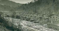 |
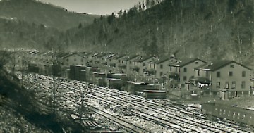
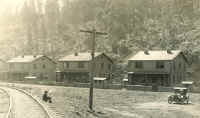
This picture was taken from the lower end of
the Lower End looking toward the Upper End. All
houses shown are two family houses. The railroad served the coal
tipple located at entrance to the Lower End. Dunbar, like
most communities during that era, was racially segregated with part of the
Lower End reserved for Black families. |
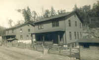 |
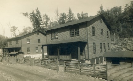
This is a closer view of two houses located on
the Back Road in the Lower End. These houses where
also for two families. The small buildings located next to the
road are coal houses. All houses where heated with coal. An
employee would order coal from the Company. An employee
would deliver the coal, back his truck near to the coal house, and then
shovel the coal through the small opening on the back. Shovels-full
were counted to determine the amount of coal delivered. It was not
uncommon for one man to deliver and unload over twenty tons of coal per
day. |
 |
These two family houses were located on the Front
Road in the Upper End. The uppermost end of the Upper
End was typically reserved as housing for Hungarians and other
employees with roots in Eastern Europe. |
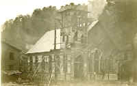 |
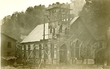
This is the Dunbar Church during
construction. This was probably taken in the early 1920's.
This church was always Protestant, and so far as I can determine, always
Methodist. The house visible in the background on the left is my boyhood
home. |
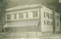 |
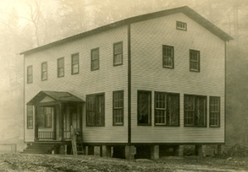
The Dunbar Store offered almost everything that
an employee might need. He could buy groceries, clothing, furniture,
toys, guns, gasoline, and many other items. This store, like most
coal camp stores, was owned and operated by the coal mine operator.
Purchases were either made with script purchased from the Company or
deducted from the employees salary. As the once-popular song said,
many employees "owed their soul to the company store."
The store building also housed the doctor's office, payroll department,
post office, and mine superintendent's office. |
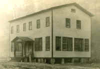 |
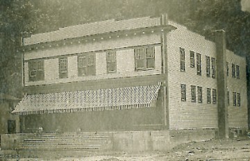
The Colored School provided elementary
school education to Black children. This school was located in the Lower
End on the Front Road. I have been told that the upper
floor was used as a high school for white students. This has not
been confirmed. |
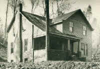 |
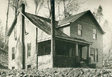
The mine superintendent's house was located on Quality
Row. The mine superintendent was responsible for overseeing the
operation of the mine(s) but also the community. This house and many
other mine superintendent's houses in the area were located on hills
overlooking the community. |
|