Abandoned & Little-Known Airfields:
Virginia: Northern Richmond area
© 2002, © 2015 by Paul Freeman. Revised 12/21/15.
Charles Field / Richmond City Airport / Eagle Rock Airport / Hermitage Airport (revised 12/6/11)
Meadow Airfield (added 5/11/13) - Northfield Airport (revised 12/21/15)
____________________________________________________
37.854, -77.425 (North of Richmond, VA)
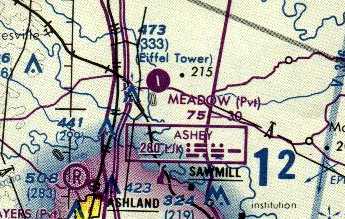
Meadow Airfield, as depicted on the 1991 Washington Sectional Chart (courtesy of Mike Keefe).
This site was originally the location of Meadow Stables, the birthplace of famous racehorse Secretariat.
In 1972 construction began on the opposite side of Route 30 of the Kings Dominion amusement park.
The Meadow Airfield was evidently constructed at some point between 1985-91,
as it was not yet depicted on a 3/1/79 USGS aerial photo nor on the 1985 USGS topo map.
The earliest depiction which has been located of the Meadow Airfield
was on the 1991 Washington Sectional Chart (courtesy of Mike Keefe).
It depicted Meadow as a private airfield having a single 3,000' paved north/south runway.
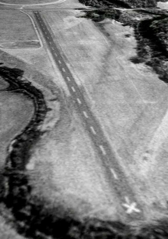
The earliest photo which has been located of the Meadow Airfield was a 3/16/94 USGS aerial view looking southwest.
It showed the field to have a single paved north/south runway, with a single small shed on the east side.
The runway was already marked with closed-runway “X” symbols at each end.
Was this merely meant to discourage drop-in visitors to a private runway,
or was it already closed by this point?
In 2003 the Meadow Event Park property was purchased by the nonprofit State Fair of Virginia, which moved the fair to the site in 2009.
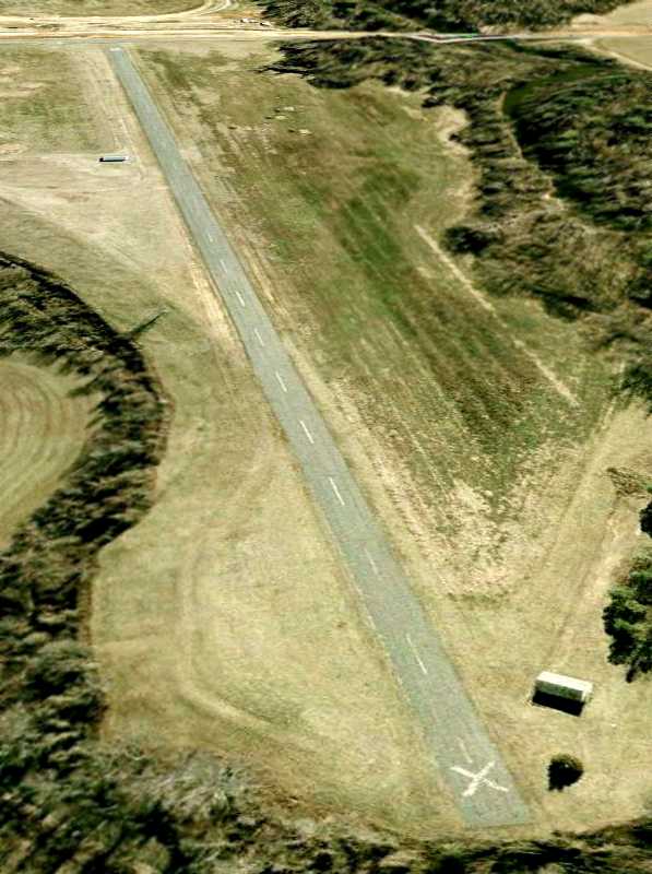
The last photo which has been located showing the Meadow Airfield still intact was a 1/31/07 aerial view looking southwest.
The runway remained completely intact, but there was no sign of any recent aviation usage.
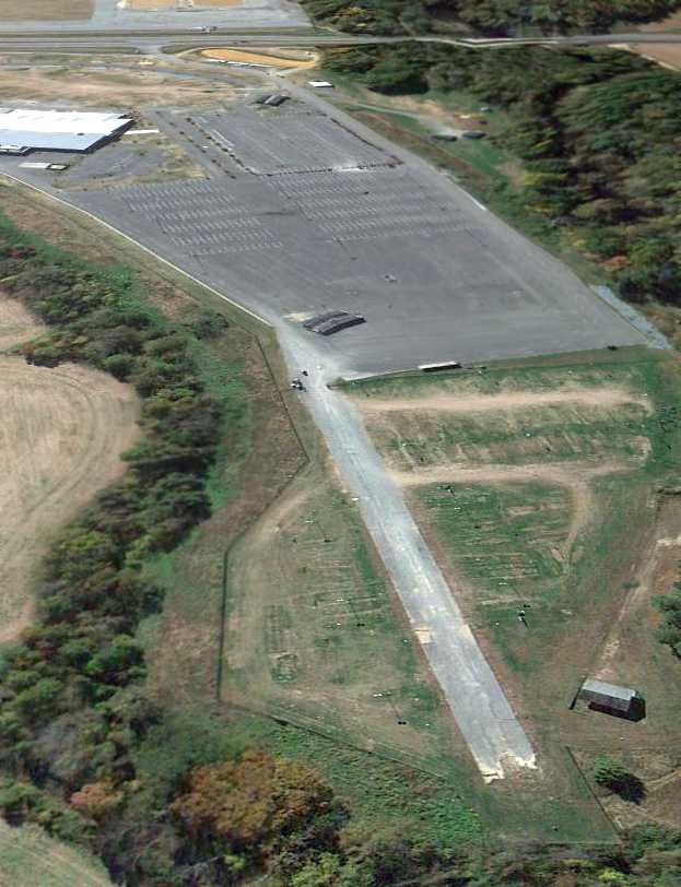
A 10/21/12 aerial view looking southwest showed a small portion of the Meadow runway remained intact on the north side,
with the majority having been covered by the parking lot & building for the VA State Fair.
The site of Meadow Airfield is located north of the intersection of Chenery Lane & Kings Dominion Boulevard.
____________________________________________________
Charles Field / Richmond City Airport / Eagle Rock Airport /
Hermitage Airport, Richmond, VA
37.586, -77.473 (Northwest of Downtown Richmond, VA)
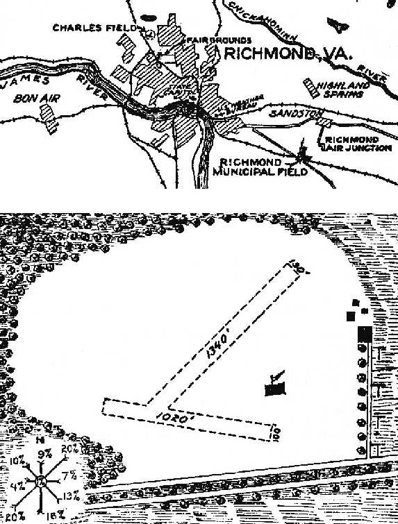
The location & layout of Charles Field, as depicted on a 1927 Commerce Department Airway Bulletin (courtesy of David Brooks).
According to the book "Virginia Airports" by Vera Rollo & Norman Crabill (published by the VAHS),
this field was originally known as “Charles Field”.
In May 1927 the officers of Dominion Flying Service joined with J. Shelly Charles of Charles Flying Service
in renting & jointly using a tract of land east of the R.F. & P. Railway tracks
and beside an extension of Laburnum Avenue for aviation purposes.
The field needed to be smoothed, and hangars were needed.
The location & layout of Charles Field, as depicted on a 1927 Commerce Department Airway Bulletin (courtesy of David Brooks).
It described the field as a 50 acre irregularly-shaped property having 2 runways, measuring 1,340' northeast/southwest & 1,020' east/west.
Several buildings were depicted on the east side of the field.
A circa 1920s photo depicted Paul Charles (brother of Shelly Charles)
at Charles Field in front of a homebuilt monoplane which he had constructed.
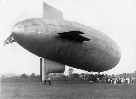
A circa 1927 photo depicting an Army blimp from Langley Field visiting Charles Field.
J. Shelly Charles applied for an airport license for the site on August 15, 1929.
Pilot Eugene Dennis proposed to help make capital available to begin a scheduled passenger service
between Richmond & Washington & Atlanta.
Despite their efforts, the company was dissolved in 1931.
A 1931 aerial view of Charles Field depicted it as an open grass area.
Charles Flying Field was operated by the Cavalier Air Service Inc. from December 5, 1931.
The Air Service's President was J.C. Harmon, a noted Marine Corps pilot.
Cavalier offered aircraft sales, storage, maintenance, and service.
The field also offered passenger rides & flight instruction,
and a banner-towing autogiro also operated from the site.
A 1932 aerial photo of Charles Field depicted it as consisting of a rectangular grass area.
A 1934 photo of Charles Field depicted 9 biplanes in front of two small wooden hangars.
The field was also known as “Eagle Rock Airport”.
The earliest aeronautical chart depiction of this field which has been located
was on on the 1935 Norfolk Airway Chart.
It labeled the field as “Richmond” Airport.
The field was evidently renamed “Hermitage Airport” at some point in the next year,
as that is how it was listed in the January 1, 1936 Commerce Department “Description of Airports & Landing Fields in the U.S.”.
It described Hermitage Airport as a commercial field,
located “one mile northwest from center of the city, Union Station & fairgrounds, east of R.F. & P. Railroad.”
The landing area was said to consist of an irregularly-shaped sod field,
with two runways, measuring 2,000' northeast/southwest & 1,500' east/west.
Buildings were said to be located along the east side of the field,
which was said to offer services during the day only.
John Currie was involved in operating Hermitage Airport,
according to the book "Virginia Airports" by Vera Rollo & Norman Crabill (published by the VAHS).
The Airport Directory Company's 1937 Airport Directory (courtesy of Bob Rambo)
described Hermitage Airport as a commercial field.
The landing area was said to consist of an irregularly-shaped sod field,
with two runways, measuring 2,000' northwest/southeast & 1,650' northeast/southwest.
Buildings were said to be located along the east side of the field,
which was said to offer services during the day only.
A 1939 photo depicted a Kellet autogiro towing a banner reading “Fly for a Dollar Hermitage Airport.”
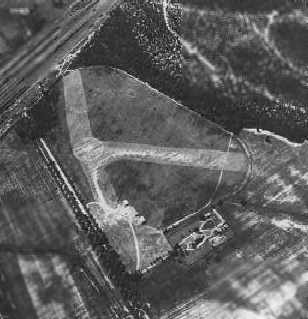
A 1939 aerial photo of Hermitage Field depicted two grass runways in a “T” shape
(the longer runway oriented east/west along the north side of Laburnum Avenue,
and the shorter runway running to the northeast), along with three hangars.
Hermitage Field was not depicted on the 1939 USGS topo map.
The August 1940 Norfolk Sectional Chart (courtesy of Chris Kennedy) & July 1941 Norfolk Sectional Chart (courtesy of Chris Kennedy)
depicted Hermitage as a commercial/municipal airport.
The April 1944 US Army/Navy Directory of Airfields (courtesy of Ken Mercer)
described Hermitage as having a 2,000' unpaved runway.
George Harper recalled, “I had a 50 minute flight lesson at Hermitage
on 10-22-44 while attending the Navy Diesel School in Richmond.”
The lesson was in a J-3 Cub, taught by G. Chury.
“The field was a large grassy rectangle.
It had several hangars at one end, east I think.”
A circa 1944 photo of Hermitage Airport depicted several J-3 Cubs around & inside a hangar,
which was marked “Richmond School of Aviation Inc.”
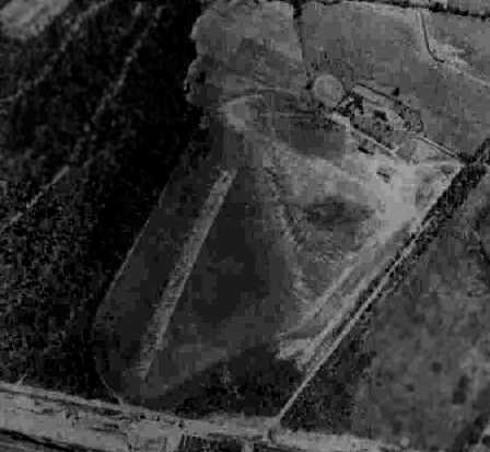
A circa 1942-45 aerial view from the 1945 AAF Airfield Directory (courtesy of Scott Murdock)
depicted Hermitage as having 3 unpaved runways.
The directory described Hermitage as a 28 acre irregularly-shaped property
within which were 3 sod runways, with the longest being a 2,000' east/west strip.
The field was said to have a total of 3 wood & metal hangars, with the largest being a 60' square structure.
The field was said to be privately owned & operated.
Hermitage Airfield, as depicted on a 1946 USGS map.
The last depiction which has been located of Hermitage Airport as an active airfield
was on the April 1946 Norfolk Sectional Chart (courtesy of Chris Kennedy).
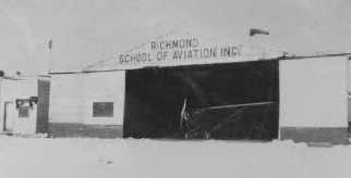
A 1946 photo of the Richmond School of Aviation Inc. hangar at Hermitage.
One plane is visible just inside the hangar, with another plane behind it “stacked” on its nose.
An article in the 8/22/48 issue of the Richmond Times Dispatch was entitled “Pioneer Local Airport Closes”.
It said, “Hermitage Airport, one of the older flying fields in Virginia, has had the last of its hangars & buildings torn down.
After more than 20 years of service in Richmond's West End,
Hermitage has suffered the fate of nearly all airports in the path of municipal expansion.”
A 1952 aerial photo showed traces remaining still recognizable of the former runways.
Hermitage Airport was no longer depicted at all
on the July 1954 Norfolk Sectional Chart (courtesy of Chris Kennedy).
Hermitage Airport was still depicted on the 1955 USGS topo map, even though it had evidently been closed already for several years.
A 1968 aerial photo showed that the northeast portion of the site of Hermitage Airport was covered by the intersection of Interstates 64 & 195,
with no trace remaining of the former airport.
As can be seen in a 2006 aerial photo,
it does not appear as if any trace remains of the former Hermitage Airport.
____________________________________________________
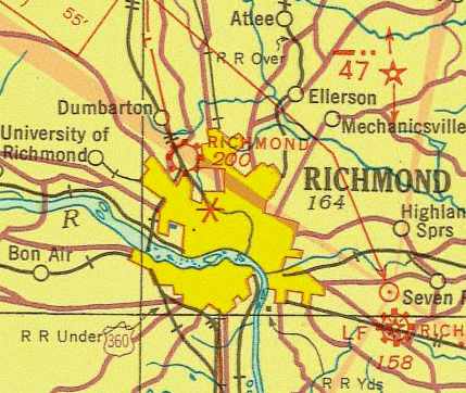
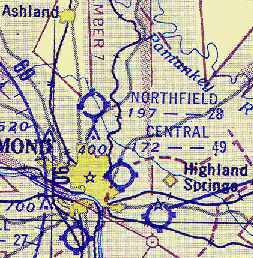
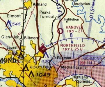
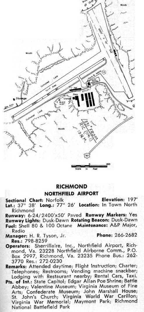
Northfield Airport, Richmond, VA
37.643, -77.43 (North of Richmond, VA)
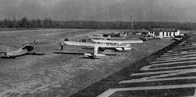
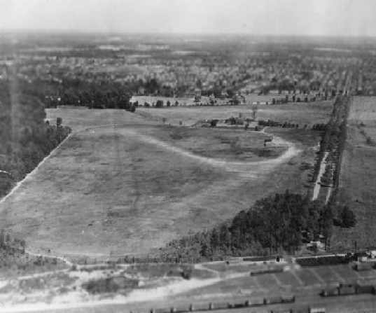
A 1952 photo of several light single-engine planes at Northfield Airport.
This small general aviation airport was located northeast of the intersection of Intestate 95 & Rt. 301,
in what eventually became the northern suburbs of Richmond
According to the book "Virginia Airports" by Vera Rollo & Norman Crabill (published by the VAHS),
Navy Lt. Cmdr. Judson Sherill applied for an operating license for an airfield at this location in 3/14/45, and was denied.
He reapplied for the license in the spring of the same year,
and his second application was approved at some point in 1945.
It was not yet depicted on the 1945 Norfolk Sectional Chart (courtesy of John Voss).
The "Northfield Air Country Club" was due to open in 1946,
with plans for runways of 2,000' & 1,800', and also tennis courts.
A 1950 photo of Northfield in the book "Virginia Airports"
showed the airport to have two grass runways & several small hangars.
The 1951 USGS topo map did not yet depict any runways, but did depict 2 small buildings at the airport location.
A 1952 photo of Northfield in the book "Virginia Airports" showed a Civil Air Patrol group at Northfield.
The earliest chart depiction of Northfield Airport which has been located
was on the July 1953 Chesapeake Bay USAF World Aeronautical Chart (courtesy of Chris Kennedy).
It depicted the field as having a 2,800' unpaved runway.
The July 1954 Norfolk Sectional Chart (courtesy of Chris Kennedy)
continued to depict Northfield as having a 2,800' unpaved runway.

An undated photo (courtesy of Kenneth Keeton) from an article describing the My 1955 dedication of a new $15,000 2,350' paved runway at Northfield Airport
which was celebrated with an air fair & open house.
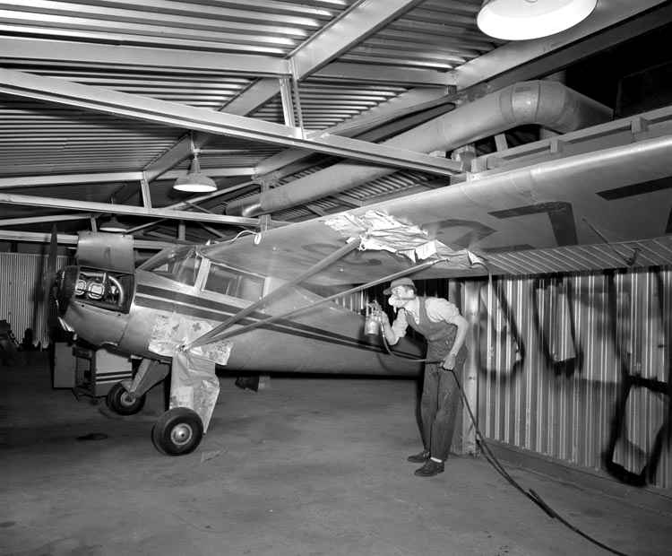
An undated photo of a Luscombe being painted inside a Northfield Airport hangar, from the Library of Virginia's Rice Collection.
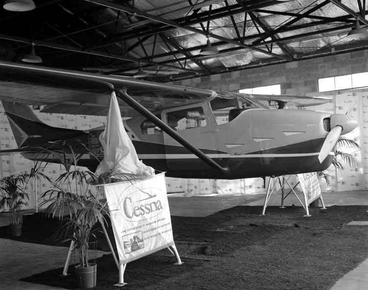
A 6/5/60 photo of a Cessna 172RG displayed with the gear retracted at a “Northfield Airport show”, from the Library of Virginia's Rice Collection.
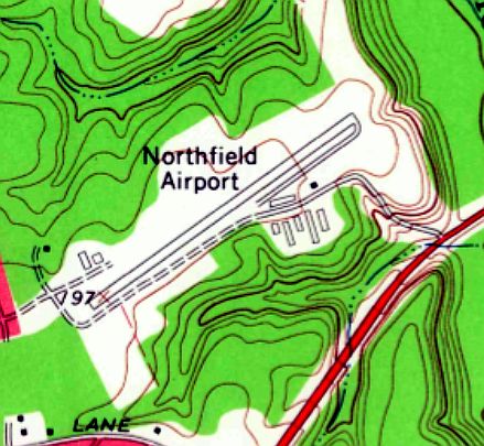
The 1963 USGS topo map depicted Northfield airport as having a paved northeast/southwest runway,
and a clearing for the grass crosswind runway.
Seven small buildings were located on the south side.
Gordon Gallison recalled, “Northfield Airport: My brother got his private pilot's license in August of 1963
and then the 2 of us promptly flew to Miami and then the Bahamas.
The first training aircraft I could remember at Northfield were Aeronca Champs.
However, they were gone by the time I began flight training in the Cessna 150s.
My first airplane ride was with Ray Tyson as he took a student for some instrument training in a Piper Tri Pacer.
The flight was a Christmas present from Ray as he was my newspaper customer. I started my flight training at Northfield in the spring of 1964.”
Gordon continued, “For landing on Runway 24, you flew over a swamp filled with copperheads & cottonmouth moccasins.
There was a significant downdraft as you approached.
At the approach end of Runway 6 was an old concrete silo & a barn on the north side of the runway.
Next to the barn was an old farm house where Ray Tyson, the airport manager lived.
My younger brother worked at the airport as it was a short bike ride from our house.
His pay was half in flying time & half in money. My brother fueled airplanes & washed others.
A WWII veteran taught me to drive an old stick-shift GMC truck on the road that paralleled Runway 6/24 to the south.
I flew out of there in a Cessna 172 for my honeymoon trip to the Bahamas in June of 1966.”
Northfield apparently gained a paved runway at some point between 1954-65,
as the 1965 Norfolk Sectional Chart (courtesy of John Voss)
described Northfield Airport as having two runways, with the primary being a 2,500' bituminous strip.
A 1966 aerial photo of Northfield in the book "Virginia Airports"
showed the airport to have a nice paved Runway 6/24, along with a sod north/south runway.
A total of at least 6 T-hangars were south of the runway,
and at least 16 light aircraft were visible on the field.
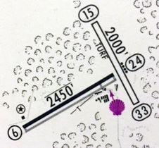
The 1967 Shell Airport Directory (courtesy of Kevin Walsh) depicted Northfield
as having one paved 2,450' Runway 6/24 & a 2,000' turf Runway 15/33.
A 1967 aerial view looking northeast along Northfield's Runway 6,
showing several light aircraft at the far end of the runway.
In 1967 the airport was offered to Henrico County,
but after much discussion it was not accepted (according to the book "Virginia Airports").
Northfield was described in the 1968 VA Airport Directory (courtesy of Don Thompson),
as having one paved 2,400' runway & a shorter grass strip,
and the operator was listed as Sherrillaire Inc.
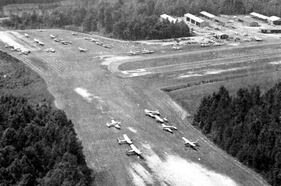
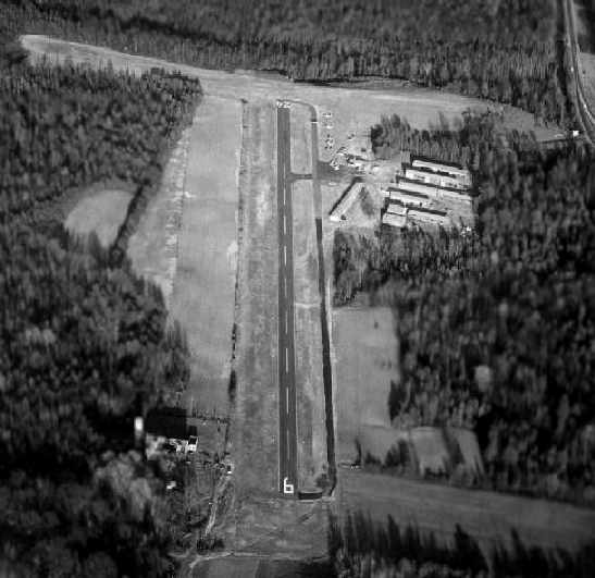
A May 1968 aerial view looking south at Northfield Airport (courtesy of Kenneth Keeton) during an AOPA clinic held at the airport.
Looks like a very well-used airport, considering it would be closed within a few weeks.
Northfield Airport was closed on 6/1/68,
and the land was put up for sale by Charles Gibbs & Judson Sherill (according to the book "Virginia Airports").
Northfield Airport was no longer depicted at all on the 1969 USGS topo map,
or the 1970 Washington Sectional Chart (courtesy of John Clifford).
Kevin Barnett recalled going to the former Northfield Airport in 1973
(which had been closed by that time) to fly kites on the runway.
"And against my mother's better judgment, we even flew a kite from the car as my dad drove down the runway."
Arfon Griffiths recalled, "I never visited the airport while it was in operation but I have played in the remaining fields MANY times as a kid.
In the 1970s one half of the field was turned into suburb housing & Parham Road was cut through the end of the grass field."
The 1996 USGS aerial photo showed that all traces of the former airport were gone,
with housing having been built on the western half of the property,
and a cleared field on the eastern half.
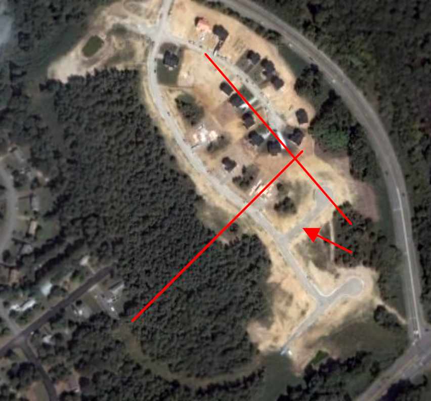
A 2006 aerial photo, annotated by Lowry Eads to show the location of the former runways of Northfield Airport.
Additional housing had been built over the eastern half of the property at some point between 1996-2006.
The site of Northfield Airport is located northwest of the intersection of Route 301 & East Parham Road.
____________________________________________________
Since this site was first put on the web in 1999, its popularity has grown tremendously.
That has caused it to often exceed bandwidth limitations
set by the company which I pay to host it on the web.
If the total quantity of material on this site is to continue to grow,
it will require ever-increasing funding to pay its expenses.
Therefore, I request financial contributions from site visitors,
to help defray the increasing costs of the site
and ensure that it continues to be available & to grow.
What would you pay for a good aviation magazine, or a good aviation book?
Please consider a donation of an equivalent amount, at the least.
This site is not supported by commercial advertising –
it is purely supported by donations.
If you enjoy the site, and would like to make a financial contribution,
you
may use a credit card via
![]() ,
using one of 2 methods:
,
using one of 2 methods:
To make a one-time donation of an amount of your choice:
Or you can sign up for a $10 monthly subscription to help support the site on an ongoing basis:
Or if you prefer to contact me directly concerning a contribution (for a mailing address to send a check),
please contact me at: paulandterryfreeman@gmail.com
If you enjoy this web site, please support it with a financial contribution.
please contact me at: paulandterryfreeman@gmail.com
If you enjoy this web site, please support it with a financial contribution.
____________________________________________________
This site covers airfields in all 50 states.