Abandoned & Little-Known Airfields:
Virginia: Southeastern Fairfax County
© 2002, © 2016 by Paul Freeman. Revised 9/17/16.
This site covers airfields in all 50 states: Click here for the site's main menu.
____________________________________________________
Please consider a financial contribution to support the continued growth & operation of this site.
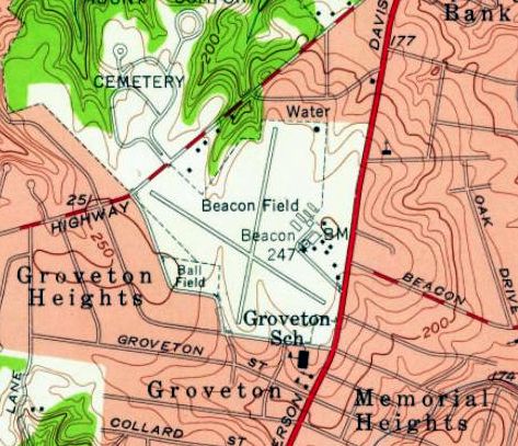
Alexandria Airport / Hybla Valley Airport (revised 9/17/16) - Beacon Field (revised 9/17/16)
EEBEE AAF (revised 9/17/16) - George Washington Air Junction (revised 9/17/16)
____________________________________________________
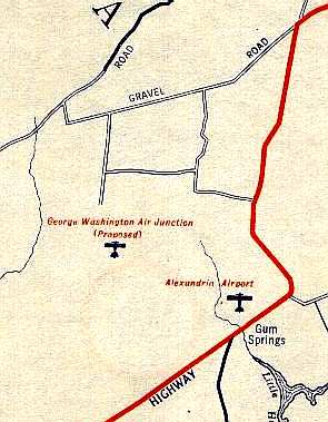
George Washington Air Junction, Alexandria, VA
38.758, -77.105 (Southwest of Reagan National Airport, VA)
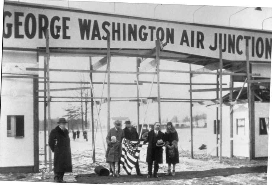
A 1925 photo of the entrance to the “George Washington Air Junction”.
In the late 1920s, entrepreneur Henry Woodhouse purchased 1,500 acres of land in Fairfax County
in a grandiose plan to transform Hybla Valley's dairy farms into the "George Washington Air Junction",
which he planned as Washington’s transatlantic commercial airport.
This was envisioned as the largest airport in the world,
with a 7,200' runway & mooring fields for transatlantic Zeppelin flights.
Woodhouse was convinced that Zeppelins were the future of aviation.
The earliest depiction which has been located of the George Washington Air Junction
was a 1925 photo showing the entrance sign, evidently still under construction.
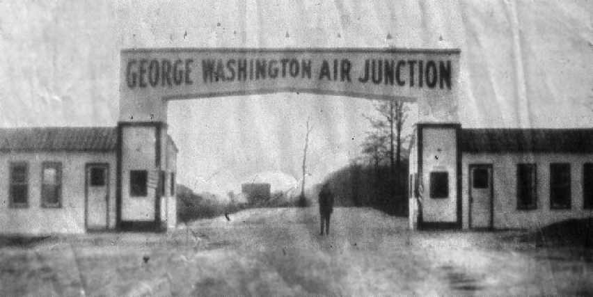
An undated photo of the entrance to the “George Washington Air Junction” (from the Fairfax County Library, courtesy of Charlie Davis).
The entrance was presumably located along what is now Lockheed Boulevard, near the entrance to today's Huntley Meadows Park.
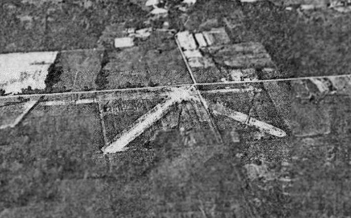
A 1929 aerial photo by Orville Blake (courtesy of Charlie Davis) looking north at the 3 runways which were cleared on the Air Junction property,
just south of what would eventually become Lockheed Boulevard.
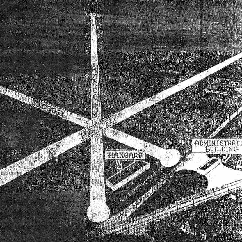
An aerial photo looking south at the Air Junction site, annotated with the intended layout of the airport
(from the 3/3/38 issue of the Herald Times, from the Fairfax County Library, courtesy of Charlie Davis).
The photo depicted a plan for 3 runways (including one 14,000' long, which would have been bizarre for an airport in the 1930s),
along with a hangar & an administration building.
The article said, “Hybla Valley, largest available airport site near the Capital.
Hybla Valley, flat as a table & 3,800 acres in extent, lies 3 miles south of Alexandria, flanked by U.S. Highway #1.
On it could be located the largest runways in the world,
and it could be converted into the largest airport in the world.”
In spite of its grandiose plans, the Air Junction never went into operation,
and there is no indication that any aircraft ever operated from the site.
It was never depicted on any government-published aeronautical chart that has been located.
Woodhouse eventually lost the land through a combination of defaults, foreclosures, and lawsuits.
The Washington Air Terminal Corporation leased the land to dairy farmers until 1941,
when the federal government purchased it for $60,000.
A 1949 aerial photo no longer showed any trace of the 3 runways which had been depicted in the 1929 aerial photo.
From 1950-59, the VA National Guard's Battery D, 125th Gun Battalion located antiaircraft artillery batteries
on a site just to the northwest of the former Air Junction property,
as one of 4 batteries which provided air defense coverage for the nation's capital.
The battery was manned by 4 officers & 30 enlisted men.
In 1958, a site just to the southwest of the Air Junction site
was used by the Naval Research Laboratory for the highly classified development of the AN/GRD-6 Direction-Finding Antenna,
for which they constructed 2 large circular antenna fields.
When the NRL project wrapped up in 1971, the property was declared surplus by the federal government.
In 1975, the Interior Department, under its "Land to Parks" program initiated during the Ford administration,
sold 1,261 acres of surplus land (including the former Air Junction site) to Fairfax County for $1.
The land was to be used "exclusively for public park or public recreation purposes in perpetuity”,
and it became the Huntley Meadows Park.
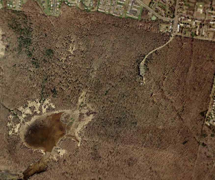
As seen in the 2002 USGS aerial photo, the site of the George Washington Air Junction
has become the Huntley Meadows Park,
and not a trace is visible of the 3 runways which were depicted in the 1929 aerial photo.
The site of the George Washington Air Junction is located southwest of the intersection of Lockheed Boulevard & Harrison Lane.
____________________________________________________
38.774, -77.086 (Southwest of Reagan National Airport, VA)
![]()
Can you believe this is Alexandria, VA?
An aerial view of Beacon Field in 1934, looking north (courtesy of Don Thompson).
According to the book "Virginia Airports" by Vera Rollo & Norman Crabill (published by the VAHS),
the aviation use of this property began in the 1920s,
when an aeronautical beacon was installed on the site,
as part of the Department of Commerce's network of commercial airways which ran along routes between major cities.
Aubrey Burdette rented some open land at the site from the Reid family to begin giving flying lessons & rides.
Burdette Flying Service quickly became quite busy,
and also employed Sanford Gulick as an instructor.
Bob Ashburn eventually joined the staff,
and in time the Ashburn Flying Service took over from Burdette Flying Service.
It wasn't until 4/11/32 that a license was granted for Beacon Hill Airport (according to the book "Virginia Airports").
No airfield at the location was yet depicted
on the May 1932 J-18 Washington D. C. Airway Map (courtesy of Chris Kennedy).
The earliest official listing for Beacon Field which has been located
was in the 1934 Department of Commerce Airfield Directory (according to Chris Kennedy).
It described the field as consisting of an irregularly-shaped sod landing area,
measuring 1,200' north/south x 1,500' east/west.
![]()
Beacon Field & Alexandria Airport, as depicted on the 1935 Washington Sectional Chart.
The January 1, 1936 Department of Commerce Airway Bulletin
described Beacon Field as a commercial field, consisting of an irregularly-shaped sod field,
measuring 1,500' east/west by 1,200' north/south.
It was said to be operated by the Department of Commerce,
and to offer facilities for servicing aircraft, day & night.
![]()
An undated aerial view looking west at Beacon Field (courtesy of Charlie Davis).
The Airport Directory Company's 1937 Airports Directory (courtesy of Bob Rambo)
described Beacon Field as consisting of an irregular sod landing area, measuring 1,500' x 1,200'.
The aerial photo in the directory depicted a hangar at the north edge of the field.
![]()
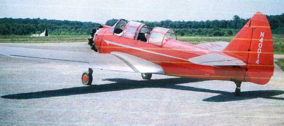
A circa 1939 photo of Charles Duggar in front of a 1938 Aeronca NC27783 Model K (2 cylinder) chocked & running at Beacon Field.
A hot summer day – the windows fully extended in the upstairs airport office in the building on the left.
According to the book "Discovering Loudoun",
radio celebrity Arthur Godfrey learned to fly at Beacon Field,
and later named his estate Beacon Hill in honor of the airport.
Godfrey also later bought the George Farm airfield in Leesburg, which later became Godfrey Field.
Prior to World War II, Beacon Field hosted the Civil Aeronautics Administration Region 1 Aviation Safety District Office.
In 1940, a group of African-American pilots incorporated the Cloud Club in Washington, DC.
They began flying at Beacon Field in their own airplane, a 1939 Piper Cub Coupe.
Things did not go smoothly for the Cloud Club in Alexandria, though.
Very soon they were accused of violating airfield rules,
and were soon kicked out of Beacon Field.
They moved to Croom Field in MD.
According to the book "Virginia Airports",
as WW2 began, Beacon Field was closed to civilian flying,
and was used by the military as a Civilian Pilot Training Program base,
and later for training women ferry pilots as part of the WASP program.
In 1942 the US Navy took over Beacon Field as a primary training base for Naval Aviation Cadets.
When a Navy Hellcat landed at Beacon Field, 2 furrows mere left in the macadam from the main gear,
but hardly anyone noticed the damage due to the excitement.
The April 1944 US Army/Navy Directory of Airfields (courtesy of Ken Mercer)
described Beacon Field as having a 2,000' runway.
The 1945 Haire Publishing Company Airport Directory (courtesy of Chris Kennedy)
described Beacon Field as having 4 sod runways
(with the longest being a 3,000' northwest/southeast strip),
and said that the field also had 2 hangars.
However, that description of a 3,000' runway was doubted by Merton Meade,
who recalled, “There just wasn't that much room there.”
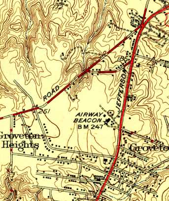
The 1945 USGS topo map depicted an Airway Beacon & several buildings at the site of Beacon Field, but did not label the airport.
According to the book "Virginia Airports",
"Following the war Harry Lehman took over the airport business with his family.
For a time business boomed.
Sixty planes were hangared there & many others were tied down outside."
![]()
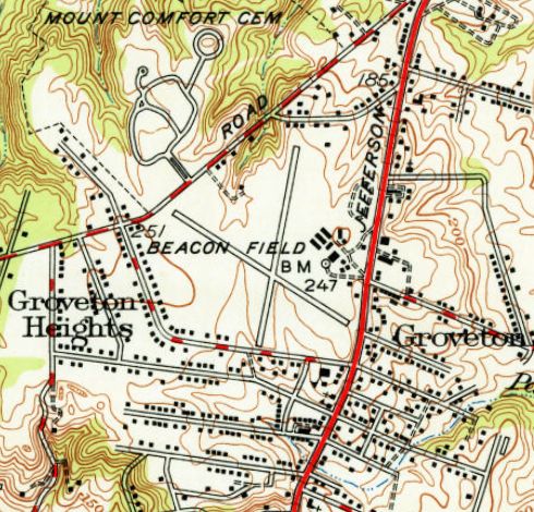
The 1946 USGS topo map depicted Beacon Field, as well as the nearby Alexandria Airport.
Merton Meade recalled, “Harry Lehman... was vice-president;
Franklin Reid, his brother-in-law, was president,
and Franklin's sister & Harry's wife, Mary Lewis Lehman nee Reid, was also on the masthead.”
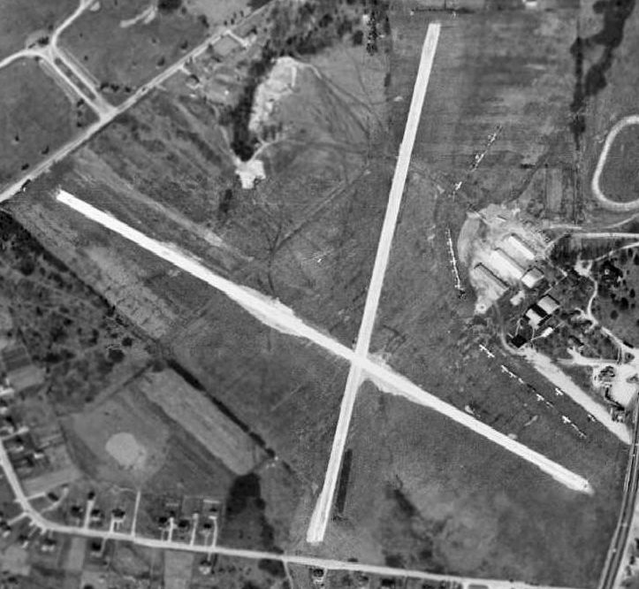
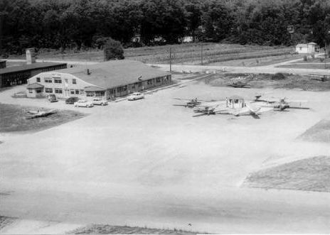
A 1949 aerial view depicted Beacon Field as having 2 unpaved runways,
with 5 hangars & numerous other buildings on the east side of the field.
A total of 28 light aircraft were visible parked on the east side of the field.
![]()
The 1949 USAF Target Complex Chart depicted Beacon Field as having two 2,000' runways.
![]()
A 1949 photo by Art Brown (courtesy of Robert Brown) of a Schweizer 1-23 at a 1949 glider meet at Beacon Field.
A Beacon Field hangar & light beacon tower are in the background at right.
![]()
A 1949 photo by Art Brown (courtesy of Robert Brown) of a Laister-Kauffman LK-10A (identified by Norman Kellman)
at a 1949 glider meet at Beacon Field.
A Beacon Field hangar & light beacon tower are in the background at right.
The Washington Soaring Club held the first Mid-Atlantic Soaring Contest at Beacon Field in 1949.
Due to its close proximity of Washington, the meet received unequaled newspaper coverage.
Kim Scribner won the meet, after he thrilled the crowd with low-level glider aerobatics
such as slow rolls on tow & outside loops in his Schweizer 1-23 sailplane.
The second Mid-Atlantic was held again at Beacon Field in 1950.
The club moved to Martinsburg, WV the next year.
![]()
Beacon Field was described on the 1951 Washington Sectional Chart (courtesy of Mike Keefe)
as having 2 runways, with the longest being a 2,313' hard-surface strip.
The 1951 USGS topo map depicted Beacon Field as having 2 paved runways & a cluster of buildings on the east side.
The 1956 USGS topo map still depicted Beacon Field as having its namesake beacon tower on its east side.
Beacon Field's namesake beacon tower was was repossessed by the Federal Government in 1957.
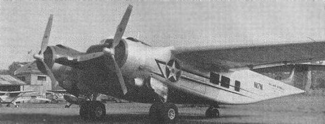
An undated photo of the Canadian Car & Foundry Loadmaster 1 which spent 2 years at Beacon Field.
An interesting sidebar to the Beacon Field story concerns an unusual prototype aircraft
which resided at the field late in the airport's history.
The Canadian Car & Foundry company built eight examples of the Loadmaster 1,
which was an aircraft of the Burnelli concept, in which the fuselage was configured as an airfoil,
in an attempt to maximize lift & reduce drag.
A Loadmaster made a demonstration at nearby Fort Belvoir VA in 1957,
when the US Army was exploring potential for a new troop carrier.
During the demonstration, the Loadmaster made a forced landing, and was removed to Beacon Field.
It remained at Beacon Field for the next 2 years,
until an inspection revealed that it had suffered only minor damage:
a bent propeller & skin tearing from the belly-landing.
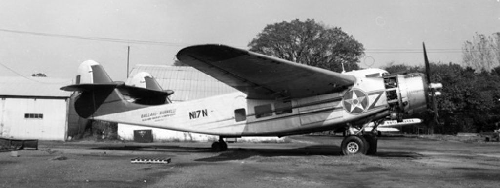
An undated photo of the Canadian Car & Foundry Loadmaster 1 at Beacon Field.
In 1959, as Beacon Field was closing down to make way for a housing development,
the Loadmaster, after an unusually short takeoff run, took off from Beacon Field.
According to Tom Beamer, the Loadmaster flew to Baltimore’s Friendship Field (now BWI),
where it was parked in the mid to late 1960s never to fly again.
Craig Lynch recalled of Beacon Field, “I grew up behind the airport & saw it torn down as a young boy.
The Reid family owned the land the airport was on & the Reid mansion was on the airport property.
I played in the Loadmaster & saw it leave the airport.”
Merton Meade recalled, “The Burnelli aeroplane:
I can recall sitting in my 10th grade science class at Mount Vernon High School on US 1 several miles south of Beacon Field
and looking out the window... not an unusual thing... and saw this 'thing' being towed up the highway.
When I got to the airport that afternoon, there was the Burnelli sitting there after it's minor crash at Ft. Belvior.
It sat there for a couple of years whilst Paul Zimmer's shop did repairs on it.
The cockpit of the Burnelli was laid out as an almost carbon copy of the DC-3.
Beacon actually closed in the autumn of 1959,
but it was some time after that when Paul Zimmer & Marvin Heintzel actually flew the thing over to Friendship in Baltimore.
It sat there for quite a few years & is now at the museum in Windsor Locks, Connecticut.”
Before Beacon Field closed, one of the masonry buildings that had housed a Link Flight Simulator
was moved to adjacent family land.
According to the book "Virginia Airports", "On 9/30/59 the Beacon Field hangar doors closed for the last time
and another historic airport disappeared."
The Reid & Lehman families closed the airport on 10/1/59.
The City View antebellum mansion on the airport grounds was torn down in a day in the fall of 1959.
When Beacon Field closed, many of its resident aircraft moved to nearby Washington-Virginia Airport.
Harry & Mary Lehman moved his flying business across the Potomac River to Hyde Field, MD..
![]()
The last photo which has been located showing Beacon Field still intact was an 11/9/59 USGS aerial view, taken only a month after its closure.
Beacon Field was no longer depicted on the 1961 USGS topo map.
A 1962 aerial view showed that the southeastern portion of the Beacon Field property had been cleared for construction,
with one building of the new shopping center having been erected.
All of the north/south runway still remained intact, along with the western half of the northwest/southeast runway.
A 1979 aerial view showed that the western portion of the former airport property had been covered by apartment buildings,
erasing any trace of the former airport.
![]()
The 2002 USGS aerial photo of the site of the former Beacon Field showed that the property was occupied by the Beacon Hill Mall.
No trace remains of the former airfield.
As of 2008, the masonry building which had previously housed a Link Flight Simulator
reportedly still stood on adjacent family land.
Beacon Field's address was 2013 Richmond Highway.
The site of Beacon Field is located at the intersection of Beacon Hill Road & Richmond Highway (Route 1).
____________________________________________________
Alexandria Airport / Hybla Valley Airport, Alexandria, VA
38.754, -77.09 (Southwest of Reagan National Airport, VA)
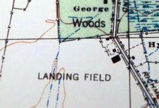
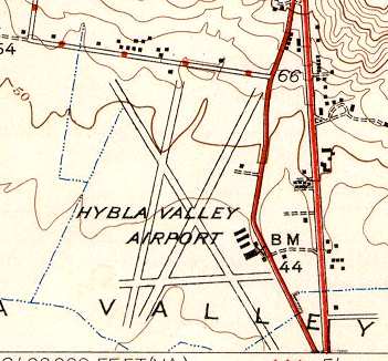
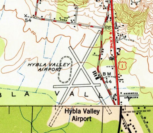
Alexandria Airport was labeled as “Landing Field” on the 1926 USGS topo map.
Elvin Robertson had started a flying business offering sightseeing rides in the late 1920s
from a field further north along the Potomac.
When Philadelphia Rapid Transit acquired the field for a railroad terminal,
Robertson moved a short distance away to Hybla Valley,
and established what was originally known as Alexandria Airport in 1925-26.
The earliest depiction which has been located of Alexandria Airport was on the 1926 USGS topo map,
which depicted an irregularly-shaped “Landing Field” with a single hangar on the east side,
with the eastern boundary formed by the original alignment of Washington & Richmond Highway (Route 1).
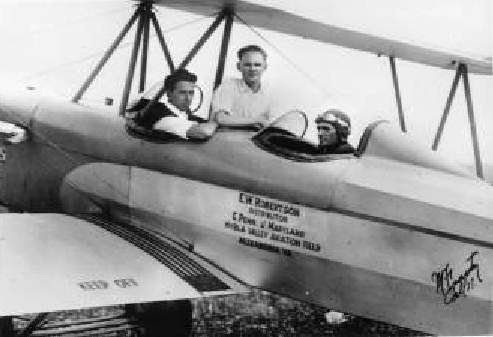
An undated photo of Elvin Robertson in the rear cockpit of one of Hybla Valley's Eaglerock biplanes.
Robertson had a Jenny biplane, a Lincoln Standard 4-place biplane with a Hispano Suiza V-8,
and later became a dealer for Alexander Eaglerocks with Curtiss OX-5 engines.
Robertson's Mount Vernon School of Aeronautics offered flight instruction,
and became popular in 1928 after Lindbergh’s New York to Paris flight.
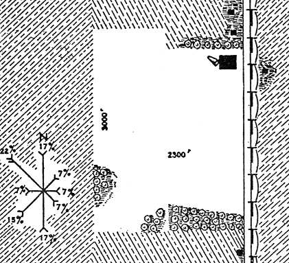
The airfield area at Alexandria Airport, as depicted on a 1929 Commerce Department Airway Bulletin (courtesy of Michael McMurtrey).
The bulletin described Alexandria Airport as consisting of a 110 acre sod field, measuring 3,000' x 2,300.
One 140' x 60' hangar was situated at the northeast corner of the field.
The owner & operator was listed as Mount Vernon Airways.
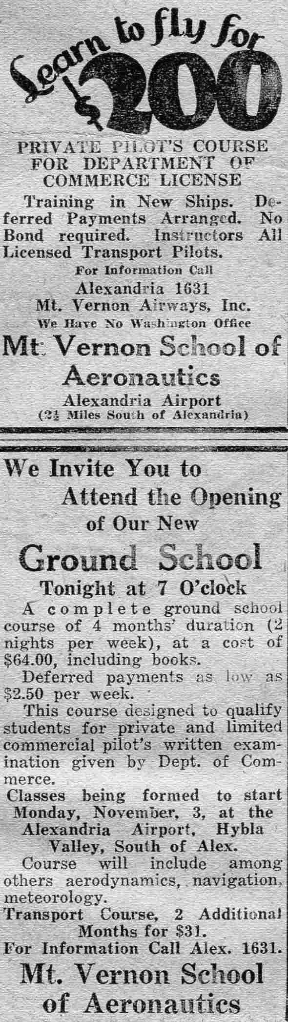
An advertisement for Alexandria Airport's Mt. Vernon School of Aeronautics from the 11/3/30 Washington Daily News (courtesy of Mickey Marche).
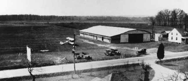
A circa 1930s aerial view looking east at the hangar at Hylba Valley, with one biplane on the field.
Alexandria Airport (as well as the never-built George Washington Air Junction),
as depicted on a 1930 Standard Oil Company road map (courtesy of Mike Keefe).
Alexandria Airport, as depicted on the May 1932 J-18 Washington D. C. Airway Map (courtesy of Chris Kennedy).
An aerial view of Alexandria Airport, 1934 (courtesy of Don Thompson).

A close-up of the hangar at Alexandria Airport, 1934 (courtesy of Don Thompson).
![]()
Beacon Field & Alexandria Airport, as depicted on the 1935 Washington Sectional Chart.
The January 1, 1936 Department of Commerce Airway Bulletin
described Alexandria Airport as a commercial field, consisting of a rectangular sod field,
measuring 2,600' x 1,200'.
It was said to have a single 3,000' northwest/southeast runway.
A hangar was said to be marked with “Mt. Vernon Airways”.
The field was said to offer facilities for servicing aircraft, day & night.
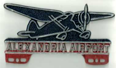
A 2012 photo by Cindy Furman of what appears to be a automobile license plate frame advertising Alexandria Airport, of unknown vintage (circa 1930s?).
Cindy reported it was “found... on our recently purchased farm in Warrenton Virginia. It is a metal sign about 10 inches x 6 inches.
The airplane is a dark blue & the lettering is silver with a red background & there are holes in the bottom, maybe for hanging?
On the back, I can make out a stamp saying New York Bronze Sign Co, Metal advertising signs, Fremont, Ohio.”
The Airport Directory Company's 1937 Airports Directory (courtesy of Bob Rambo)
described Alexandria Airport as consisting of single 4,000' northwest/southeast sod landing strip.
The aerial photo in the directory depicted a single hangar (with "Alexandria Airport" painted on the roof)
at the northeast edge of the field.
At some point, the airfield began to also go by the name Hybla Valley Airport,
although this was not consistent, as some later maps continued to label it as Alexandria Airport.
E.C. Germain operated Washington Air Charter Service from Hybla Valley prior to WW2.
This firm was a division of Mount Vernon Airways, Inc.
According to a 2/78 article by Jack Perine in the Mid Atlantic Soaring Association's Convector,
The employees of the Engineering Research Corporation (builders of the Ercoupe) operated a glider club at Hybla Valley Airport.
According to Jack Perine, “Memberships were $12, and my first solo while in 2nd year high school was in their primary glider.”
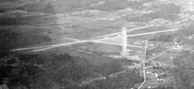
A circa 1939 aerial view looking north at Hybla Valley Airport.
In 1939, with war on the horizon, Robertson sold the field to the Navy to train military pilots.
According to Brian Rehwinkel, Hybla Valley was one of several outlying fields
used to support primary flight training at Naval Reserve Aviation Base Anacostia during WW2
(the others being Hyde, Beltsville, Cheltenham, Nottingham, and Riverside).
A 1940 aerial view depicted Hybla Valley as having 4 runways.
It was labeled simply as "U.S. Navy" on the 1940 & 1942 Washington Sectional Charts (courtesy of Mike Keefe).
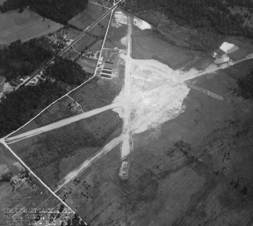
An 8/14/43 U.S. Navy aerial view looking southeast at “Hybla Valley Landing Field” (courtesy of Brian Rehwinkel).
It depicted the field as having 4 unpaved runways, with several hangars on the east side of the field.
Brian observed, “This photo was taken by the Navy, so I am assuming the Navy was still in possession of the field, or still had a lease for use of the field –
but it does not appear the Navy was actively using the field for training.”
It was listed as "Naval Air Facility, Hybla Valley"
in the 1944 US Army/Navy Directory of Airfields (courtesy of Ken Mercer),
and described as having a 5,000' runway.
After the war, the Navy established an office there to sell off WW2 airplanes,
and Hybla Valley Airport was reopened as a civil airport.
It was depicted as a commercial airport on the 1945 Washington Sectional Chart (courtesy of John Voss).
The 1945 USGS topo map depicted Hybla Valley Airport as having a total of 4 runways,
with the longest being 3,700'.
Four hangars or buildings were situated east of the runways, next to the road.
The 1945 Haire Publishing Company Airport Directory (courtesy of Chris Kennedy)
described Hybla Valley Airport as having 4 gravel runways
(with the longest being a 5,280' northeast/southwest strip),
and said that the field also had 4 hangars.
It listed the operator as Mount Vernon Airways,
and listed the manager as W. R. Ashburn.
In 1945, Bob Ashburn started Ashburn Flying Service at Hybla Valley, helped by some Standard Oil financing.
By now the field had 3 runways: 2 gravel & one paved, ranging from 2,500' to 3,000'.
Ashburn had a Cessna Bobcat twin which he used for aerial photography
and mapping terrain for highways for the now burgeoning DC area.
Eventually, the main runway reached 4,800', a pretty respectable runway for the era.
Arthur Godfrey was known to come in his DC-3.
Ashburn’s operation grew to 30 airplanes, with another 50 or 60 tied down around them.
The fixed base operation was considered one of the best in the mid-Atlantic region
with facilities for meals & lodging as well as aircraft maintenance.
Ashburn Flying Services had Cubs, Luscombe Silvaires (radio equipped),
175 hp Fairchild PT-19s for advanced training & PT-26s for instrument training.
Prices in that era were fascinating.
A medical cost $5. Dual instruction was $11/hour & solo was $8/hr.
The typical pilot training course cost $198 dual, $136 solo, plus $1 for a log book, totaling $335.
The 1945 AAF Airfield Directory (courtesy of Scott Murdock) described Hybla Valley Airport
as a 179 acre irregularly-shaped property within which were 4 gravel & clay runways,
the longest being three 5,000' strips oriented north/south, northeast/southwest, and northwest/southeast.
The field was said to have 4 cinderblock hangars, the largest being three 150' x 30' structures.
The airport was said to be privately owned & operated.
![]()
The 1946 USGS topo map depicted Alexandria Airport,
as well as the nearby Beacon Field.
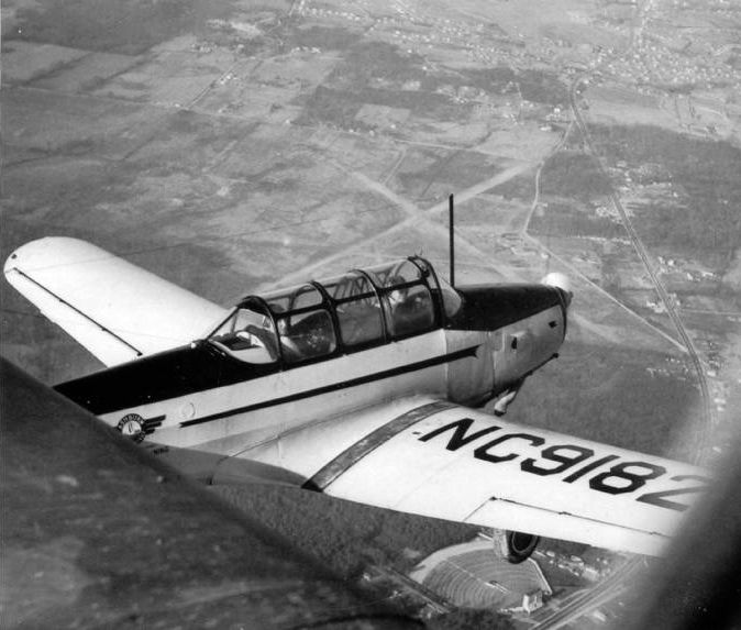
A circa 1947 air-to-air view of a Fairchild PT-26 (NC-9182) with Hybla Valley Airport visible just beyond its nose
and the Mount Vernon Drive In Theater below the landing gear.
Alexandria Airport was depicted on the 1948 Washington Sectional Chart (courtesy of Chris Kennedy)
as having a 4,800' unpaved runway.
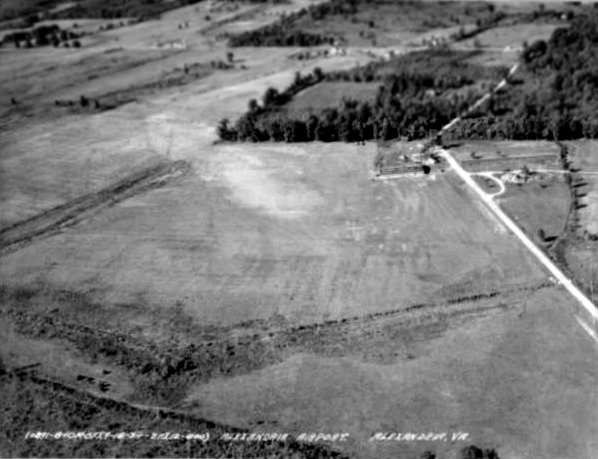
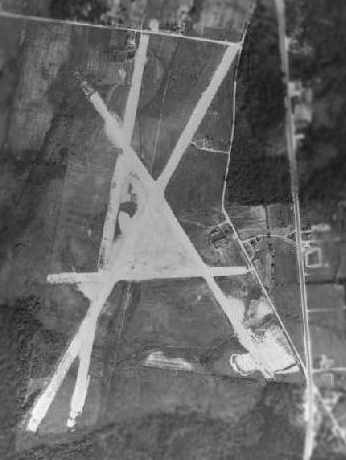
A 1949 aerial view depicted Alexandria Airport as having 3 runways.
The 4th runway (depicted on the 1945 topo map) had evidently been replaced by a horse track.
Four hangars & numerous other buildings were located on the east side of the field,
along with a total of 29 light aircraft visible parked outside.
![]()
Beacon Field & Alexandria Airport, as depicted on the 1949 USAF Target Complex Chart.
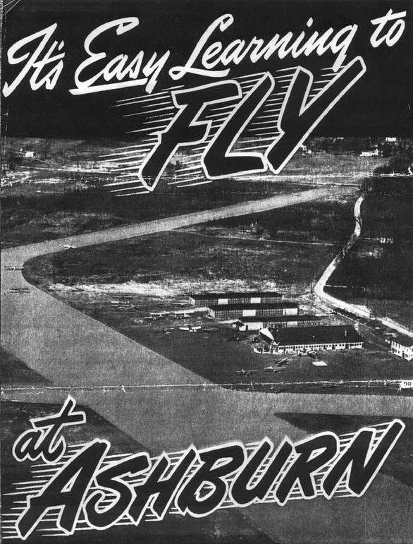
An undated (circa 1940s/50s?) advertisement for Ashburn Flying Service featuring an undated aerial view looking north at Hybla Valley's row of 4 hangars.
But all was not going well - the suburbs were surrounding the airport & the approaches were poor.
The suburbs crowded closer, and in 1950, Frank Reid, who then owned the airport,
sold it to a developer, but with a lease to continue to operate the airport until 1955.
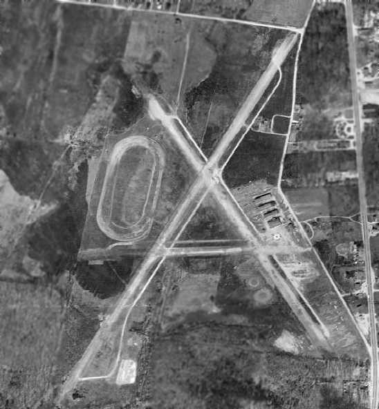
The 1951 USGS topo map depicted the 3 runways of Hybla Valley Airport, along with the oval racetrack on the airport's west side.
Alexandria Airport was described on the 1951 Washington Sectional Chart (courtesy of Mike Keefe)
as having 3 runways, with the longest being a 3,450' hard-surface strip (with a 4,800' strip available).
The last photo which has been located showing Hybla Valley Airport in operation
was a June 1953 photo (courtesy of Libby Haynes) of Libby Haynes & Ed Daggit in “Firebird”, her PT-23 at Hybla Valley.
Libby recalled, “My 'Firebird' was a Fairchild PT-23, built by the St. Louis Boxcar Company (guess I'm lucky it didn't have flanged steel wheels).
I bought it as World War II surplus in 1952 (for $500, over twice my monthly salary) and sold it in 1956 after my first child was born.
My husband flew C-124s from Dover AFB, but he would ride with me!
Originally, it was an open-cockpit airframe. Later, a model designated PT-26 was built with a sliding hatch.
This airplane was identical to the PT-19 except for a slightly more powerful engine & the hatch.
The hatch on my airplane was taken from a cannibalized PT-26.”
Merton Meade recalled, “We moved to Hybla Valley in the autumn of 1953 when I was a lad of 10 years.
My mother would take me across the street every single day to visit the airport
where absolutely NOTHING happened during the day during the week.
Weekends were quite active.
She tired of this after only a short time, so she looked up the airport owner who was Bob Ashburn,
introduced herself, and asked permission for her son to hang around.
I think this surprised Mr. Ashburn that a parent would actually ASK,
so he said if I'd behave myself I could stay around.
Even at that age I recognized this as a 'meal ticket' & the rest, as they say...
A wonderful man was Bob Ashburn, and so was his wife Betty & the 2 daughters, Jane & Barbara.
When I was at Hybla Valley, there were 2 runways in use.
One was the mile long one ending in the dump where there was several old aeroplanes,
and the other was the 3,600' gravel one.
At various times in the field's history, there was up to 4 runways there.”
Merton Meade recalled, “In the 1934 photo I recognize the big hangar which was there until after the end.
The white house was not there in 1953.
Paralleling the big hangar were 3 rows of T-hangars.
I first met Arthur Godfrey at Hybla Valley & maintained a friendship with him until his death.
At Hybla Valley, during those years, Bob Ashburn had 2 Cubs & one Luscombe.
The Cubs rented for $7.26/hour solo with a $3 premium for dual instruction.
The Luscombe was $4/hour more.”
An undated (circa 1950s?) aerial view looking northeast at a gaggle of light planes next to one of Hybla Valley's hangars.
Alexandria Airport was described on the 1955 Washington Local Aeronautical Chart (courtesy of Mike Keefe)
as having 3 runways, with the longest being a 3,450' hard-surface strip (with a 4,800' strip available).
Later came the fateful newspaper article that
"the VA State Corporation Commission yesterday canceled Ashburn Flying Services permit to operate the field",
and after 32 years, Hybla Valley Airport was to be no more.
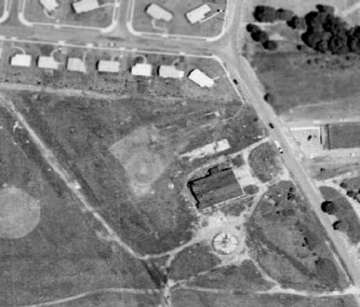
The 1956 USGS topo map still depicted the outlines of Hybla Valley Airport's former runways,
and the former hangars were still depicted on the east side,
but the airport itself was no longer labeled.
By the time of the 1957 Washington Sectional Chart (courtesy of Mike Keefe),
Hybla Valley Airport was no longer depicted at all.
A 1957 aerial view showed that Hybla Valley Airport remained intact,
but all the aircraft were gone.
A 1962 aerial view of the last remaining element of the former Hybla Valley Airport –
one hangar which remained standing for a few more years.
Three other hangars had been torn down, and houses had been built over the northern portion of the field.
The southern portion remained largely clear.
Cherrie of Hybla Valley recalled that "there were a couple of hangars on the west side of Fordson Road.
They burned down around the late 1960s.
The concrete pads the hangars sat on remained there for many years.
A condo complex now sits where the airport used to be."
Anthony Craig recalled that "I attended Hybla Valley Elementary School on Lockheed Boulevard around 1976-79.
The teachers at the school would state that the school was built on an old airfield.
Some even justified it by the flat land that surrounds us.
I remember maybe 2 very tall, like a light post, but twice the size things in the yards around the school.
I never knew exactly what they were, but the teachers stated that they were for aviation."
A 1979 aerial view showed that the last hangar was gone, with no trace remaining of the former airport.
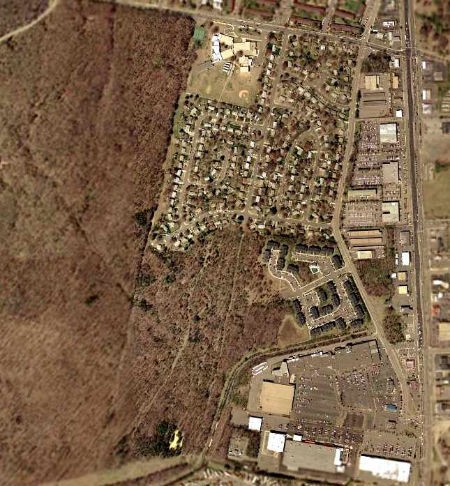
The 2002 USGS aerial photo of the site of the former Hybla Valley Airport
showed that the property has been completely redeveloped,
being occupied by the Hybla Valley School & a residential neighborhood.
However, the memory of the former airport lives on,
through the names of the streets which have been built over the former airport:
Lockheed Boulevard, Piper Lane, Convair Drive, Grumman Place,
Fairchild Drive, Stinson Road, and Northrop Road.
The site is located southwest of the intersection of Lockheed Boulevard & Richmond Highway (Route 1).
___________________________________________________
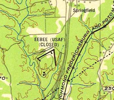
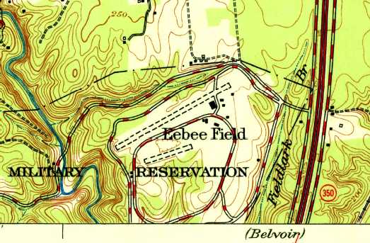
EEBEE Army Airfield, Springfield, VA
38.755, -77.192 (Southwest of Washington, DC)
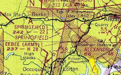
"EEBEE (Army)" airfield, as depicted on the 1948 Washington Sectional Chart (courtesy of Chris Kennedy).
This former military airfield in the Washington suburbs is a real enigma.
The author of this web site lives only 20 miles away from the site of this airfield,
and yet never realized it was there.
The exact date of construction of this airfield has not been determined.
Mary Sitton reported having an aerial photograph dated 1943
which depicted the EEBEE airfield & adjacent test track under construction.
According to Helene Danner, “The Fairfax Anti-Aircraft Artillery Range
was located on the other side of Route One from present day Davidson Army Air Field.
Apparently, targets were towed from south to north along a ridge line for gunnery training.
I would imagine that EEBEE was built primarily to support the gunnery training
and was no longer used much after the war [WW2].
I believe that the Engineer Proving Grounds moved over to the EEBEE site after the war.
The Engineer Proving Grounds was a standard corps-level proving grounds.”
A directory of military accidents listed 2 accidents
both involving Stinson L-5 Sentinels (a light liason aircraft) at EEBEE Field in 1944, and another in 1945.
No airfield at this location was depicted on the 1945 or 1946 USGS topo maps,
nor on the 1947 Washington Sectional Chart.
The earliest depiction of the airfield which has been located
was on the 1948 Washington Sectional Chart (courtesy of Mike Keefe).
It described "EEBEE (Army)" as having a 2,800' hard-surface runway.
The derivation of the name “EEBEE” was explained in an article entitled “The Engineer Proving Ground: What’s in a name?”
in the 8/16/07 issue of the Belvoir Eagle.
It said “This area was originally identified as the Engineer Board (E.B.) Test Area, but,
over a period of time came to be called Eebee Field,
because it also contained a facility & landing strip for aircraft testing.
One can see how E.B. easily converted to Eebee in everyday speech.”
EEBEE was depicted as a closed airfield on the September 1948 USAAF Pilot's Handbook (courtesy of Chris Kennedy).
The earliest photo which has been located of the EEBEE airfield was a 1949 aerial view.
It depicted the field as having 2 runways,
with a single large arch-roof hangar just southwest of the runway intersection.
There were no aircraft visible on the field.
The 1949 USAF Air Target Complex Chart labeled the field as "EEBEE (USAF) (Closed)".
It depicted the airfield as having two 2,600' runways,
as well as a single building (a hangar?) just southwest of the runway intersection.
So this airfield was built & then closed after less than 4 years?
This airfield's labeling on the 1949 chart as a "USAF" facility may have been in error.
There is no other indication of there ever having been any Air Force facilities in this area of Northern Virginia.
The Air Force had only become an independent service the year before,
which meant that mapmakers would have been very busily re-labeling a lot of former Army airfields as Air Force facilities,
but this one may have been done in error.
It was most likely always an Army facility.
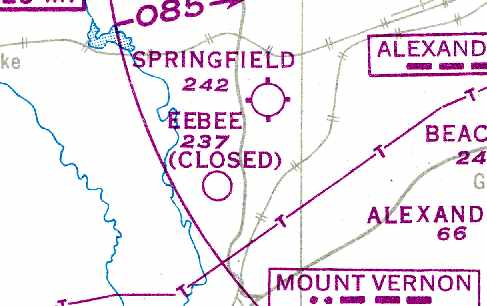
The 1951 USGS topo map depicted "Eebee Field" as having 2 unpaved runways, both oriented northeast/southwest, with several buildings.
Strangely, the north/south runway on the east side was no longer depicted.
The 1951 Washington Sectional Chart (courtesy of Mike Keefe)
depicted "EEBEE (Army)" as having a single 2,750' hard-surface runway,
with the remark, "Official business only."
Art Follansbee recalled, "I worked at the Belvior R&D Labs in the 1960s to 1982.
EPG [Fort Belvoir Engineering Proving Ground] was the test area for the Labs' activities.
The hangar was open-ended & at that time used for test projects & storage.
The old time workers told me that light Army aircraft used the strip until Davidson AAF was built in the mid-1950s.
The 'runway' was then used for night vision testing,
many WW2 tanks used as targets were hauled out of the woods & sent to the FT Knox armor museum
as EPG began to shut down."
The EEBEE airfield was apparently closed at some point between 1951-55,
as no airfield at all was depicted at the location on the 1955 Washington Local Aeronautical Chart (courtesy of Mike Keefe).
The 1956 USGS topo map continued to depict 2 unpaved runways, labeled as “Test Area”.
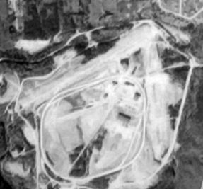
A 9/9/59 USGS aerial view depicted the field in basically the same configuration as seen in 1949,
with 2 runways & a single hangar at the northeast corner.
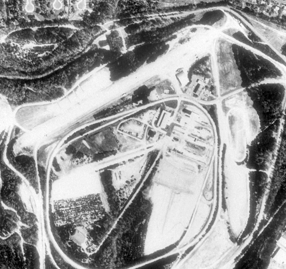
A 1979 aerial view showed that a 2nd large hangar was added on the southwest side of the field
at some point between 1959-79.
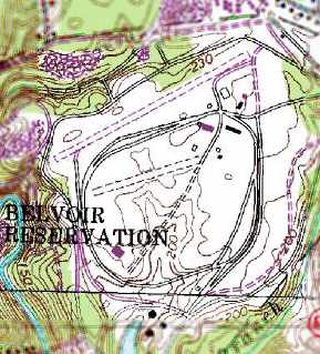
Two unpaved runways were still depicted (but unlabeled) on the 1984 USGS topo map.
The overall property was labeled as the Fort Belvoir Military Reservation.
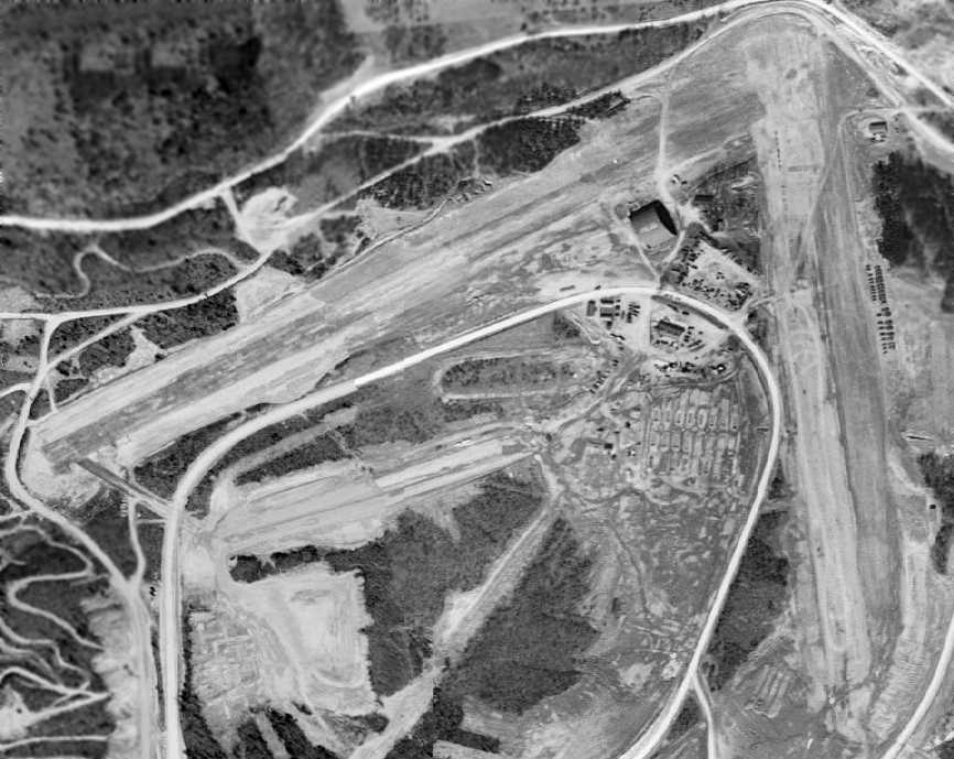
The 1988 USGS aerial photo of the EEBEE airfield site showed that the outline of both former runways were still very much recognizable,
and the former hangar still sat just southwest of the runway intersection.
The location of this airfield was depicted on later street maps as the Army's Fort Belvoir Engineering Proving Ground.
According to Mike Kentes, the Proving Ground closed in approximately 1991.
Fort Belvoir itself is located a few miles to the southeast, on the other side of Interstate 95.
A 1994 USGS aerial photo of a building which sat at the southwest corner of the former EEBEE airfield.
Mike Kentes recalled, “I visited it on 2 occasions.
The building was a large hangar-type structure that was used for Electro-Magnetic Pulse testing.
I guessed it was used for EMP testing because there were thousands of pieces of paper
all over the floor about protecting against EMP pulses.
The inside was a large wooden platform covered with sand, with a test stand in the middle, about the size of a phone booth.
It was all-around weird. When I say large, I mean LARGE, it could have held a blimp.
But sadly it is no longer there. It was used by the Fairfax County Fire Department as a training burn.”
Ron Natalie recalled, "I've seen that 'shadow runway'
and what appears to be a hangar many times back when we were allowed to fly there."
[Before the imposition of overzealous post-9/11 restrictions on general aviation flights.]
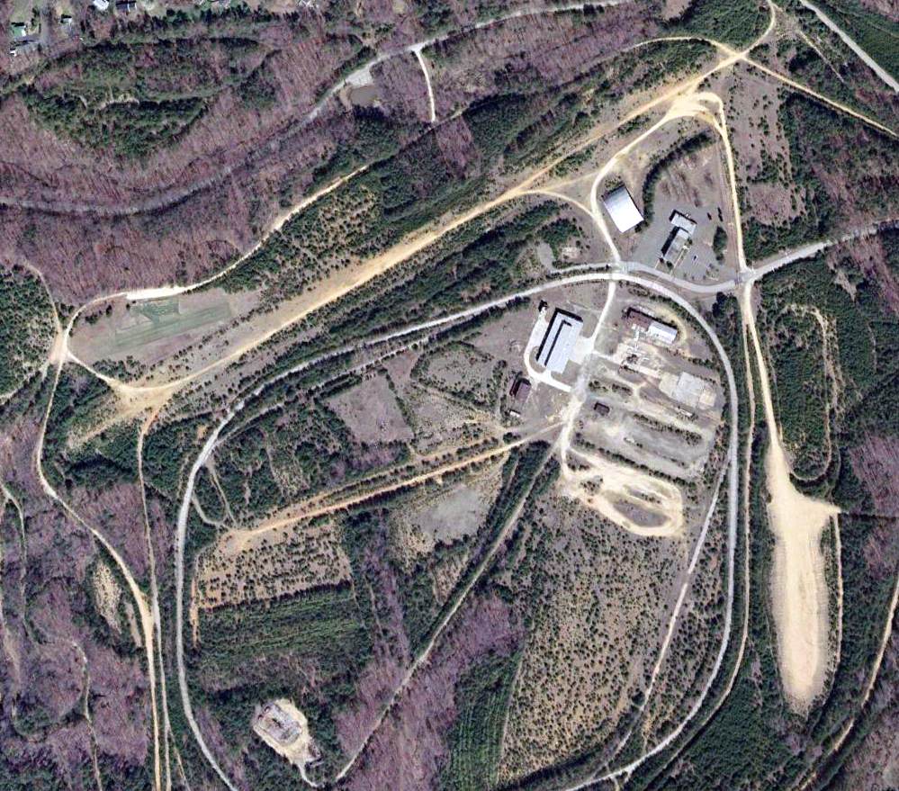
In the 2002 USGS aerial photo of the site of the former EEBEE airfield,
the outline of both former runways were still very much recognizable,
and the former hangar still sat just southwest of the runway intersection.
But the hangar-type building at the southwest corner was evidently removed at some point between 1994-2002, with only its foundation still visible.
Note the radio-controlled aircraft "runway" just north of the west end of the east/west runway.
Jon Gravelin reported in 2003, "At the left hand end of the upper dirt strip (runway) is a small grass strip.
This is, or was, back in 1999, a grass runway for Radio Controlled Aircraft, which is how I know about the area.
An organization called the Pohick Pilots Association was allowed by the Army to operate that strip.
The only condition was that we were to notify the nearby Control Tower (Ft. Belvoir, I think) when commencing operations.
One afternoon, I lost control of the aircraft I was flying & began a futile search & rescue recovery operation.
I owned a Jeep at the time, which was perfect for exploring the area in search of the plane.
The building in the upper right, with the parking lot, is still used today.
The other building seemed to be abandoned or for storage.
The hangar-shaped building next to it, is in fact a hangar.
I got reasonably close to the other major structure,
and it also looked like a hangar or some sort of warehouse.
The large diamond/oval road, is some sort of vehicle 'Test Track'.
I drove down a section of it & the corners have some grade built into them,
this leads me to believe it could have been a high speed track used when it was a proving ground.
It was a very interesting site - makes you wonder what type of testing went on there."
The Fort Belvoir Engineering Proving Ground site was mentioned in news reports in 2003
as one proposed location for a new baseball stadium for an expansion Major League Baseball team.
However, for anyone who has driven through the infamous "mixing-bowl" traffic nightmare
at the intersection of Interstate 95 & the Washington Beltway,
this would seem to be a totally unsuitable location for a baseball stadium.
Rolland Watenpaugh (Fairfax County Police Senior Flight Officer) recalled in 2004,
"I seem to recall that one of the projects tested at the EEBEE airfield
on the circular track was for smart military vehicles.
They were supposed to be able to follow an electronic bread trail in the track
and control braking & acceleration to maintain following distance.
I believe this was for the development of minimally manned resupply convoy concept.
I'm sure this is only one of many projects that were conducted there.
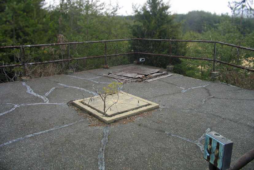
The site also contains numerous abandoned munitions bunkers to the southwest of the runways."
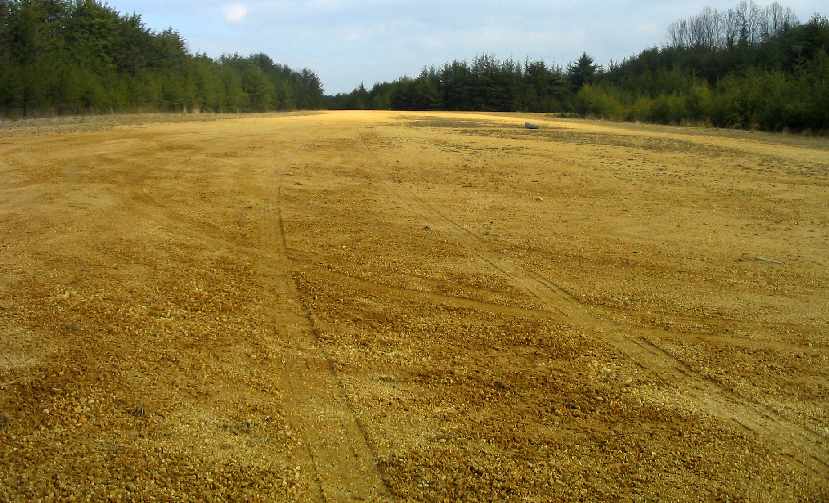
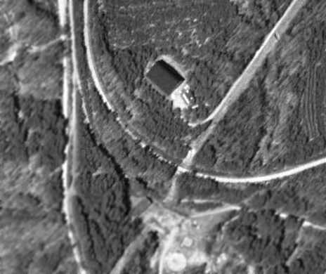
A March 2005 photo by Paul Freeman looking along the north/south runway at the EEBEE airfield.

A March 2005 photo by Paul Freeman looking along the eastern portion of the asphalt test track which runs inside the runways of the EEBEE airfield.
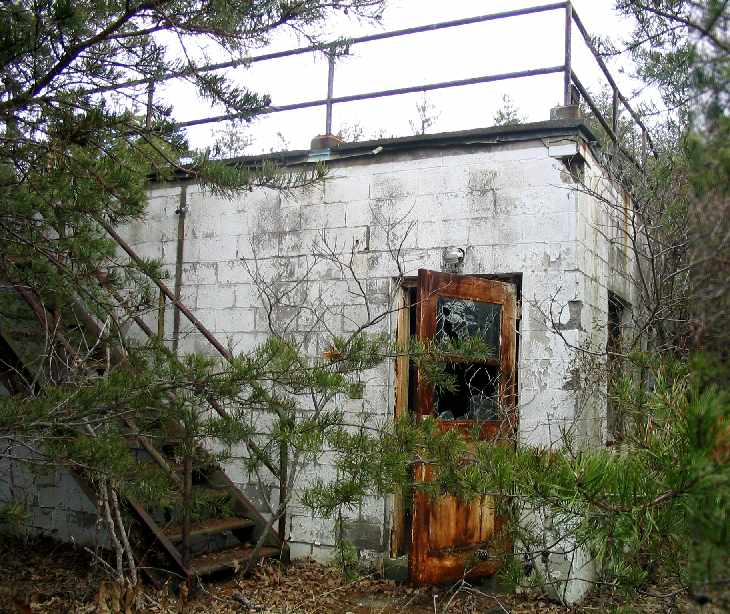
A March 2005 photo by Paul Freeman of an abandoned building which sits surrounded by woods on the east side of the EEBEE airfield.
According to Mike Kentes, this building “was an old telescopic observatory.
The observatory dome was removed, and is located in a field (in the middle of the test track).”
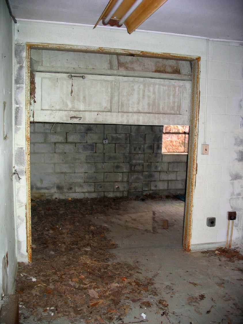
A March 2005 photo by Paul Freeman of the interior of the abandoned building on the east side of the EEBEE airfield.
A March 2005 photo by Paul Freeman of fittings (presumably for the former observatory dome)
on the roof of the abandoned building on the east side of the EEBEE airfield.
Mike Kentes reported in 2005, “It is my understanding that the entire Engineering Proving Ground
(with the exception of the white building) is owned by Fairfax County.”
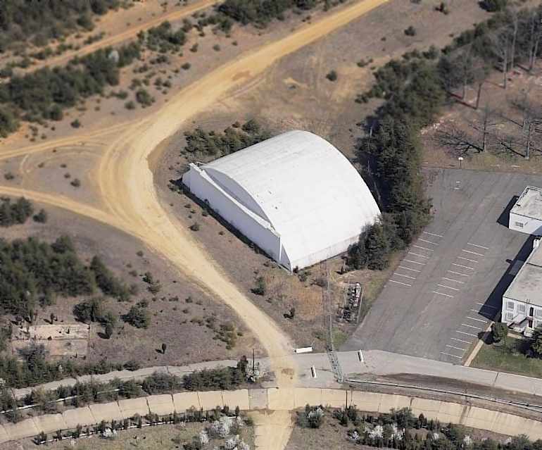
A circa 2005 aerial photo looking north at the 60-year-old former hangar on the northeast side of the EEBEE airfield.
It was reported in 2006 that “within the next 5 years” the Fairfax County Parkway would be constructed through EPG property,
and that other parts of the property were planned for office buildings, housing, and a hospital.
A 2007 aerial photo showed the hangar still remained standing on the north side of the EEBEE airfield site.
Scott Logan reported in 2008, “I drove by the old Ft. Belvoir Proving Ground gate the other day
and tried to see if the field was still there but there was a tremendous amount of construction going
on as several main-post commands are moving over there as well as the new Walter Reed Army Hospital so couldn’t get on.”
Aerial photos from 2008 show massive construction covering the site of EEBEE Field,
with several new roads covering the site of the former runways.
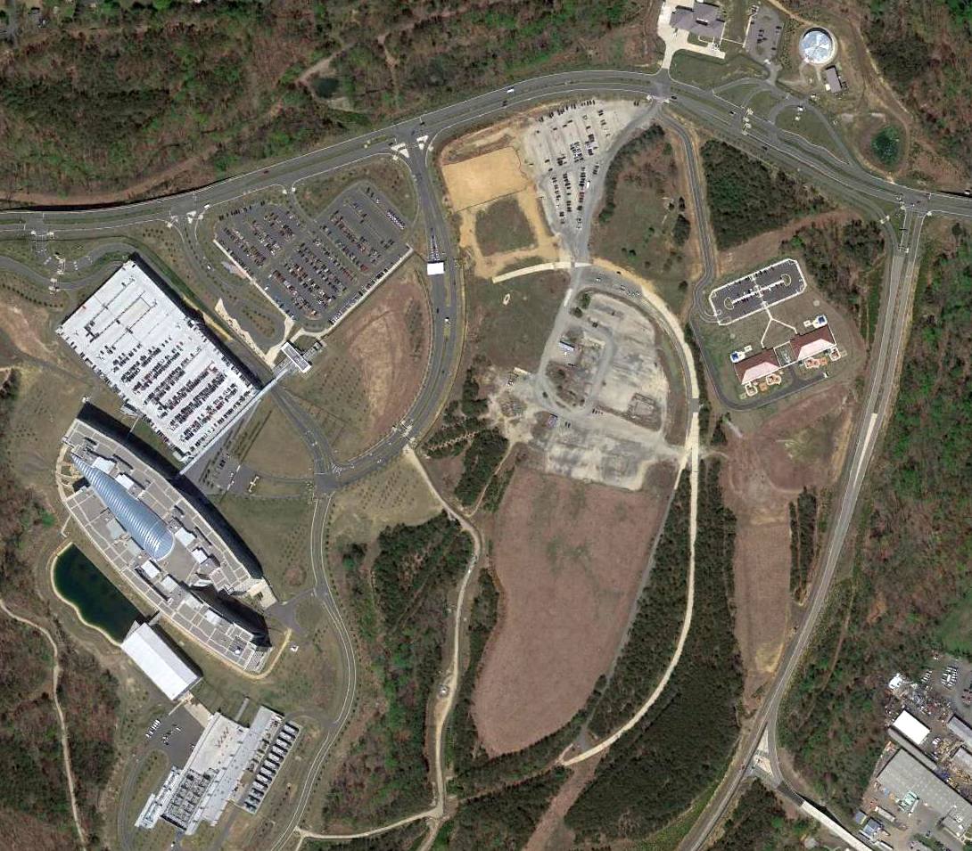
A 2016 aerial photo showed the massive facility of the National Geospatial Intelligence Agency covering the site of EEBEE airfield,
the only remaining trace of the airfield is the rough alignment of the southeastern runway end.
____________________________________________________
Since this site was first put on the web in 1999, its popularity has grown tremendously.
That has caused it to often exceed bandwidth limitations
set by the company which I pay to host it on the web.
If the total quantity of material on this site is to continue to grow,
it will require ever-increasing funding to pay its expenses.
Therefore, I request financial contributions from site visitors,
to help defray the increasing costs of the site
and ensure that it continues to be available & to grow.
What would you pay for a good aviation magazine, or a good aviation book?
Please consider a donation of an equivalent amount, at the least.
This site is not supported by commercial advertising –
it is purely supported by donations.
If you enjoy the site, and would like to make a financial contribution,
you
may use a credit card via
![]() ,
using one of 2 methods:
,
using one of 2 methods:
To make a one-time donation of an amount of your choice:
Or you can sign up for a $10 monthly subscription to help support the site on an ongoing basis:
Or if you prefer to contact me directly concerning a contribution (for a mailing address to send a check),
please contact me at: paulandterryfreeman@gmail.com
If you enjoy this web site, please support it with a financial contribution.
please contact me at: paulandterryfreeman@gmail.com
If you enjoy this web site, please support it with a financial contribution.
____________________________________________________
This site covers airfields in all 50 states.