Abandoned & Little-Known Airfields:
Texas, Northern Dallas area
© 2002, © 2016 by Paul Freeman. Revised 10/2/16.
This site covers airfields in all 50 states: Click here for the site's main menu.
____________________________________________________
Please consider a financial contribution to support the continued growth & operation of this site.
Dallas North Airport (revised 10/2/16) - Highland Park Airport (revised 10/2/16) - North Dallas Jetport / Frisco Airport (revised 6/2/13)
Irving Airport (revised 10/4/15) - Park Cities Airport (revised 10/2/16) - Shiloh Airport (revised 10/2/16)
____________________________________________________
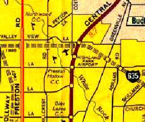
Park Cities Airport, Farmer's Branch, TX
32.906, -96.888 (Northwest of Dallas, TX)
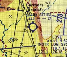
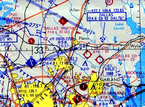
Park Cities Airport, as depicted on the September 1954 DFW Local Aeronautical Chart (courtesy of David Brooks).
This small general aviation airport was built in 1951,
according to Henry Stuart, who leased the land & built the airport (according to Kim Pierce).
According to Joe Hancock,
"I think it may have been called Joe Field prior to being called Park Cities.
In the early 1950s it was operated by Henry Stuart who later became DFW airport board chairman."
According to Terry Smith, “My father, Guy Joe Smith, and Henry Stuart grew up together & both showed an avid interest in aviation.
After the war Guy Joe joined the Navy Reserve at Hensley Field, flying the F4U Corsair.
Henry had started the Park Cities Airport & had recently 'hot topped' the runway (laid a layer of asphalt over the gravel).
He invited Guy Joe to bring an F4U over & land & they could have lunch.
Even though it was a fairly short runway, Guy Joe made a full-flap carrier landing & stopped with no problem.
It was a hot summer day, so taking off might be a little more difficult.
After lunch, Guy Joe climbed in the F4U & taxied to the end of the runway.
Feeling somewhat apprehensive about the takeoff, he lowered full flaps & firewalled the throttle.
He barely cleared the fence at the end of the runway & flew back to Hensley.
Just as he shut the engine down at Hensley, a mechanic ran out to the plane & said he was wanted on the phone.
At the other end of the line was Henry Stuart & Dad said he was 'hoppin’ mad'.
The prop blast from that F4U had disintegrated most of the new asphalt on the runway
causing Henry to close the airport until the runway could be graded & resurfaced.
I believe Dad helped Henry pay for the resurface but their friendship was never the same again!”
The earliest depiction of Park Cities Airport which has been located
was on the 1954 DFW Local Aeronautical Chart (courtesy of David Brooks),
which depicted the field as having a 2,400' unpaved runway.
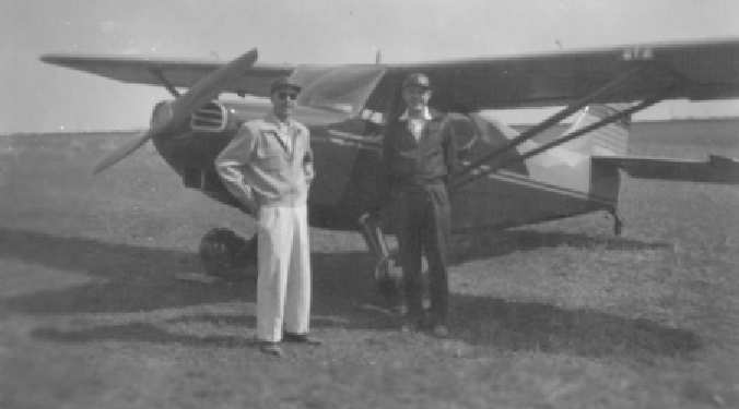
A circa 1954 photo of Dick Farmer & Maury Condon in front of their Stinson at Park Cities Airport (courtesy of Joe Hancock).
John Whitney recalled, “Park Cities Airport... I was a 12 years old when Mr. Burkhardt hired me to mow the northeast/southwest runway, fill the planes with gas & other duties.
I have got memories of Bill & Jim Pollard who were both my flight instructors & defined me as a soldier
and little did I know that in 10 years their mentorship would help me in Vietnam.”
Bill Sterling recalled that "Approximately 3/4th of a mile south of Park Cities Airport
there was then a street running west from the railroad named Joe Field Road",
and he recalled that "there was a prominent property owner in that area years prior to that time by that name."
Bill Sterling recalled, "Sometime in 1958, as a 14 year old,
I began going along with my pastor, Bailey Duncan, on flights based at Park Cities Airport.
We frequented the airport for the next 3 or 4 years.
The airport & flight school were run by Bill Burkhardt.
Another prominent individual there was Bob Geisinger, whom may have been a partner with Burkhardt.
Rental aircraft I remember flying in were a Piper J3 Cub, Cessna 120 and a beautiful red Piper Super Cruiser.
There was also a Mooney Mite available.
Bill & Bob built an experimental pusher, open cockpit, tandem, tail dragger
of which they named 'The Geisinger Enterprise'.
As I remember, these guys were quite the characters & a lot of fun to be around."
Bob continued, "The J3 Cub provided my first flight experience from Park Cities.
A year or so later I rode right seat in the Cessna 120 cross country
from Park Cities to Cox Field, Paris, TX.
For the Park Cities/Paris outbound leg we used the old A/N Range for navigation (now that brings back memories).
For the return flight it was dead reckoning.
Approximately 10 minutes after lift off facing the western sun
we were forced to take quick evasive action to avoid collision with a TTA scheduled flight inbound to Cox Field."
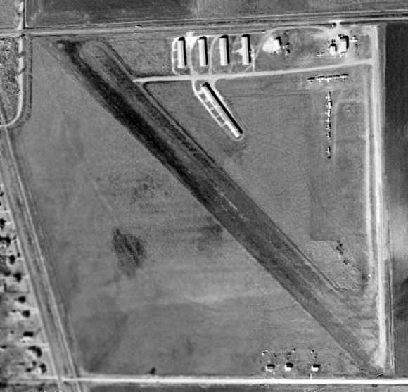
The last photo which has been located of Park Cities Airport was a 1958 aerial view.
It depicted Park Cities Airport as having 2 runways.
Several hangars & a total of 14 single-engine aircraft were visible on the northeast side of the field.
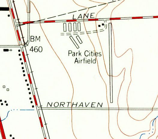
The 1959 USGS topo map depicted Park Cities Airfield as having a single north/south runway,
with 2 small buildings on the north side of the field.
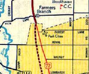
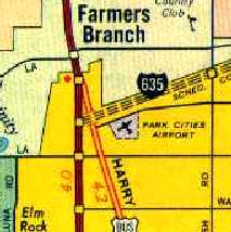
Park Cities Airport, as depicted on a 1960 Humble Oil DFW road map.
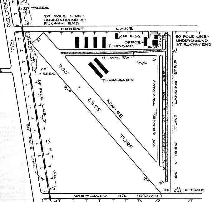
The 1963 TX Airport Directory (courtesy of Steve Cruse)
described Park Cities Airport as having a 1,750' asphalt Runway 17/35 & a 2,395' turf Runway 13/31.
A total of 7 hangars, an office building,
and a Civil Air Patrol building were situated along the north side of the field.
The operator was listed as Park Cities Aviation Inc., and the manager was listed as W.R. Burkhart.
Park Cities Airport was evidently closed at some point between 1963-64,
as it was labeled as “Abandoned Airport” on the 1964 DFW Local Aeronautical Chart (courtesy of John Price).
However Jim Sparr recalled, “In 1965-67 I was a CAP cadet with Irving Composite Squadron.
I can confirm that we were still flying L-16 Aeronca Champs out of both Park Cities & Highland Park during that period.”
Park Cities Airport was still depicted on a 1966 Conoco DFW road map,
even though it had been closed for at least 2 years already by that point.
Note that the proposed alignment of the adjacent 635 Freeway,
the construction of which had spelled the end for the little airport.
According to Bill Sterling, Interstate 635 / LBJ Freeway was built over the airport, leading to its demise.
A 1972 aerial photo showed that Interstate 635 had been built over the northern part of the former airport property.
The remainder of the airport property had been heavily rebuilt,
and not a trace appeared to remain of the former airfield.
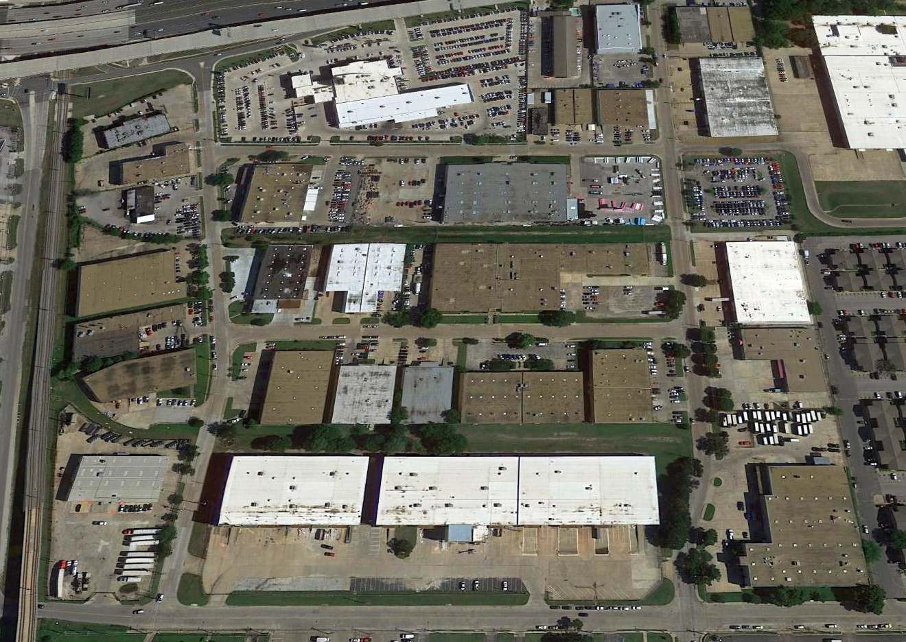
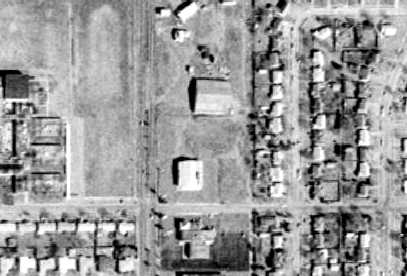
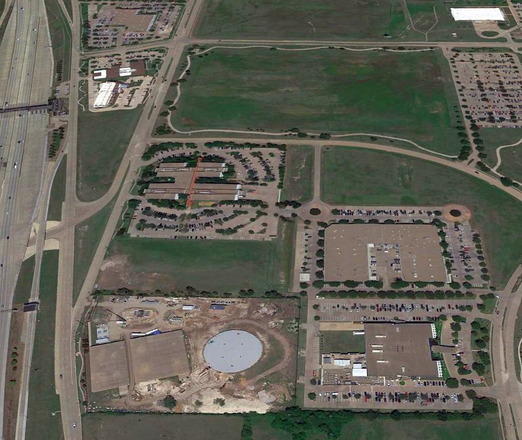
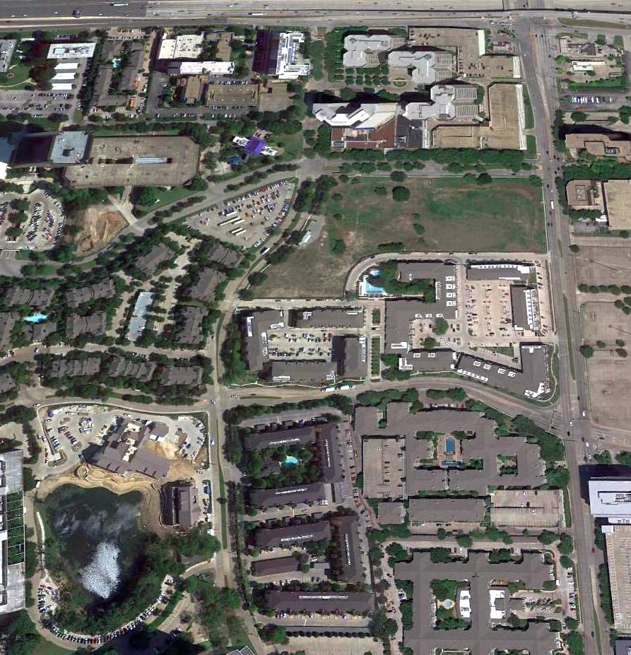
A 2016 aerial view looking north at the site of Park Cities Airport shows Interstate 635 runs over the northern portion.
Otherwise, the site has been heavily rebuilt, and not a trace appears to remain of the former airfield.
The site of Park Cities Airport is located southeast of the present-day intersection of Interstate 635 & Denton Drive.
Thanks to Joe Hancock for pointing out this field.
___________________________________________________
32.83, -96.975 (Southeast of DFW International Airport, TX)
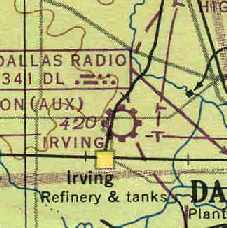
Irving Airport, as depicted on the March 1947 Dallas Sectional Chart (courtesy of Chris Kennedy).
Photo of the airport while in operation has not been located.
Irving Airport was apparently built at some point between 1945-47,
as it was not yet depicted on the March 1945 Dallas Sectional Chart (courtesy of David Brooks).
The earliest depiction of Irving Airport which has been located
was on the March 1947 Dallas Sectional Chart (courtesy of Chris Kennedy).
Clyde Haggard recalled that "I grew up in Irving (Northern Dallas County),
and when I was very young there was an Irving Airport operating."
"The airport was located South of Highway 183 (now the Airport Freeway, but that refers to DFW International Airport),
East of Story Road, and North of Grauwyler Road.
Hangars & other buildings were on the East side of Story Road
with the runway running North/South to the East of the hangars."
"One of our neighbors had a broken propeller,
and the story was that pilots used to fly from Irving Airport to Love Field in Dallas,
and would follow Grauwyler Road from the South end of the Irving Airport over to the West side of Love."
Irving Airport was depicted on the February 1949 Dallas Sectional Chart (courtesy of David Brooks)
as having a 2,800' unpaved runway.
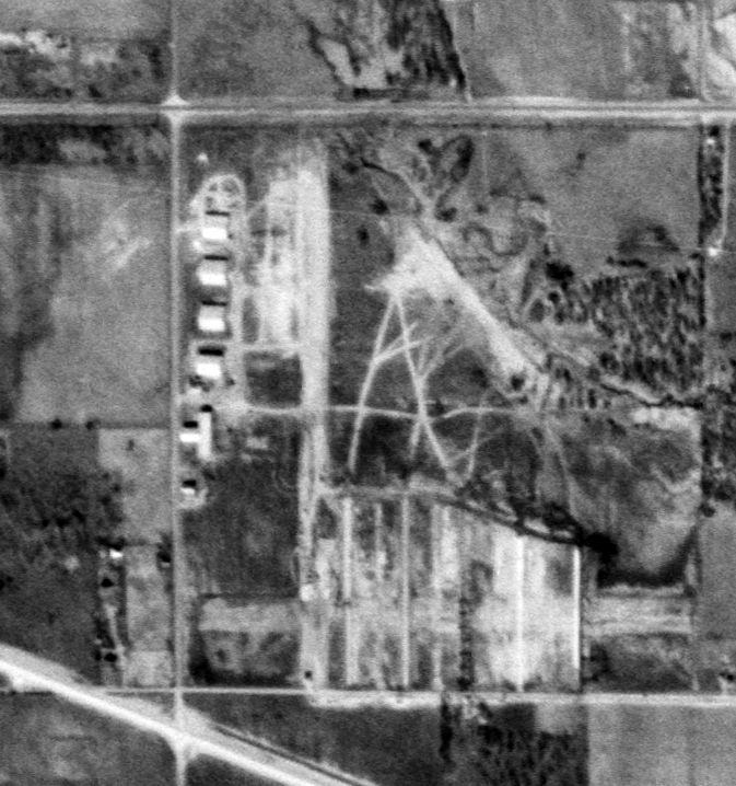
The only photo which has been located of Irving Airport was a 1/4/53 USGS aerial view.
The airport may have already been closed by that point though,
as residential construction appeared to have begin on the south side of the property.
But the row of 5 hangars remained intact on the west side of the property,
with a single unpaved north/south runway to the east of the hangars.
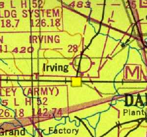
Irving Airport was closed by 1954, as it was no longer depicted on the September 1954 DFW Local Aeronautical Chart (courtesy of David Brooks).
Clyde Haggard recalled, "I don't remember exactly when it closed,
but Plymouth Park Shopping Center was built on the Southern part of the site,
opening in 1955, and a lot of homes were built immediately East of the airport.
However, for many years a few remaining hangars were still in evidence on the East side of Story Road.
I attended Junior High School across Story Road from 1956-59 & the airport had closed before that."
A 1958 aerial view of the site of Irving Airport depicted the row of 4 hangars which remained on the east side of Story Road.
The former airfield area had been covered by housing.
Richard Elston recalled, “My family moved to Irving in 1959
and after the area east of Story Road had been developed with mid/late-1950s housing.
My family lived 3 blocks south of Grauwyler.
As a kid, we played in the wooded area east of, what is now, Lively Elementary school
and I remember huge chunks of concrete; broken & scattered.
It was explained to me, I was 6 years old, this was an old airfield from the 1940s.
There were no roads nearby just trees & fields.
If this was part of an old runway the concrete pieces would have been ½ mile east of the Story Road hangars.
I also remember 4 large hangars on Story Road across from Crocket Jr. High & I was told these were military hangars.
They were huge with the curved roof line like you would see in a WWII flying movie.
I remember at least 4 of them in the early 1960s.”
A 1972 aerial view showed the northern-most former hangar still remained standing,
whereas the other 3 had been removed.
A 1979 aerial view showed that the last former hangar had been removed at some point between 1972-79,
but its foundation was still visible.
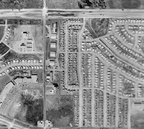
A 1989 aerial view showed that new construction had covered the foundation of the last former hangar,
erasing the last trace of the former Irving Airport.
Clyde Haggard observed in 2003, "I don't know if the residential area on the [east] was built on any of the airport land.
The commercial area with large buildings & parking
that runs down the East side of Story Road was definitely airport property.
I don't see any remains of the airport today."

A 2015 aerial view showed no trace recognizable of Irving Airport.
___________________________________________________
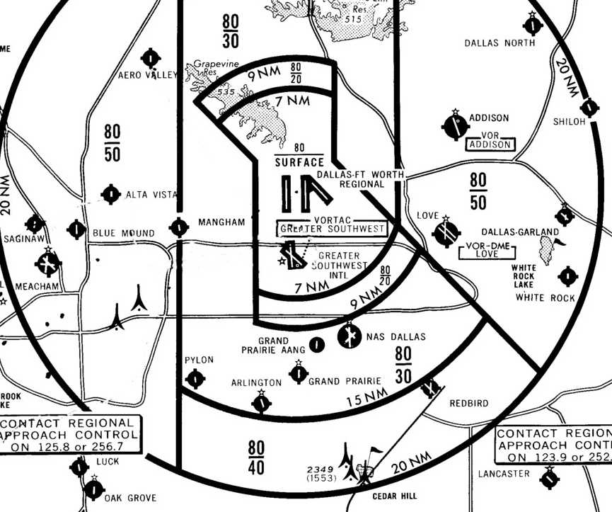
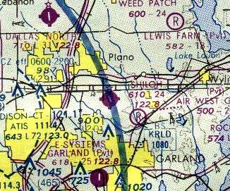
Shiloh Airport, Richardson, TX
32.99, -96.663 (North of Dallas, TX)
Shiloh Airport, as depicted on the 1968 USGS topo map.
This little general aviation airport was evidently built at some point between 1964-68,
as it was not depicted on a 1957 aerial photo nor on the 1964 DFW Local Aeronautical Chart (courtesy of John Price).
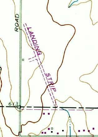
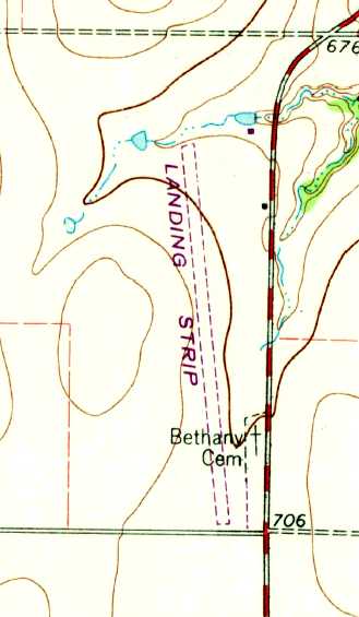
The earliest depiction which has been located of Shiloh Airport was on the 1968 USGS topo map,
which depicted a single unpaved northwest/southeast runway, labeled “Landing Strip”,
with a taxiway leading to a single small building along the west side.
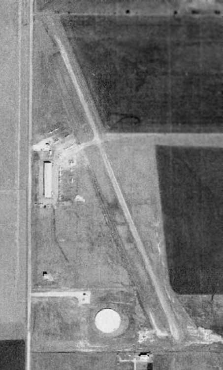
The earliest photo which has been located of Shiloh Airport was a 9/19/68 USGS aerial photo.
It depicted Shiloh Airport as having a single paved northwest/southeast runway.
There did not yet appear to be any buildings on the field, but 5 single-engine aircraft were parked on the west side of the field.
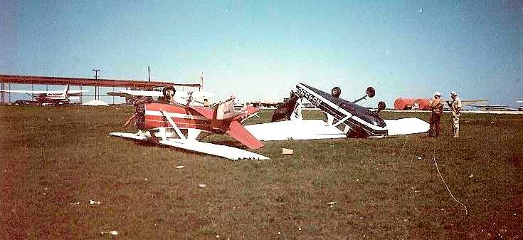
A late 1969 photo (courtesy of Bobby Moorehead) depicted the aftermath of a tornado at Shiloh Airport, showing 2 wrecked Cessna 150s.
What appeared to be the framework of a hangar still under construction appeared in the background.
The earliest aeronautical chart depiction which has been located of Shiloh Airport
was on the 1969 DFW Sectional Chart (courtesy of Ron Myres).
It depicted Shiloh Airport as having a 3,000' unpaved runway.
Orville Mather recalled, “I spent a lot of time there as a kid, our property was at the south end of the runway.
In 1969 it was not much more than a narrow runway with a few tie down spots.
Sometime around 1970, or 1971 a storm tore it up pretty good & that's when they built the T-hangars.”
Bobby Moorehead recalled, “My father Royce Moorehead... He & a partner leased Shiloh after a tornado destroyed it (in 1970).
My family rebuilt it after the storm destroyed it.
My mother & older brother and sister basically rebuilt it with my father.
He had a flying school there for a while but gave the school to his partner so he could work with the city of Richardson to make it a municipal airport.
His partner left & he brought Ferris Odell in since the airport that Ferris was at was closing (Garland Airport).
I remember that we would sleep in cots to guard the repossessed airplanes that he had on tiedown from a bank.
He held at least one airshow there.”
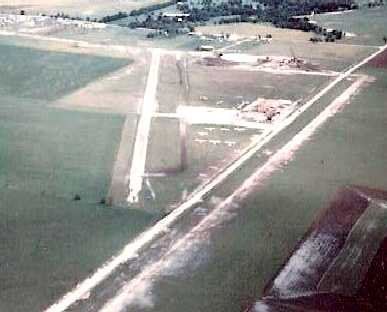
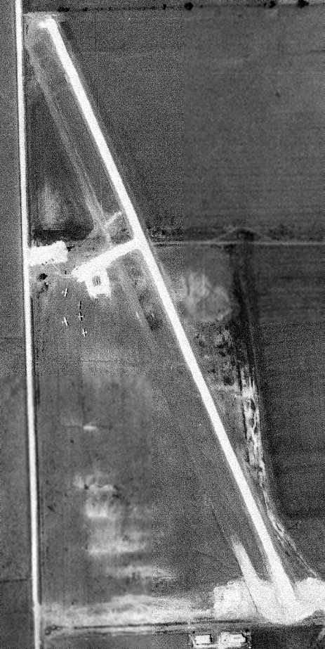
A 1970 aerial view looking southeast at Shiloh Airport (courtesy of Bobby Moorehead),
showing the field to have a single paved northwest/southeast runway,
with a parallel taxiway, ramp, and several light aircraft on the west side.
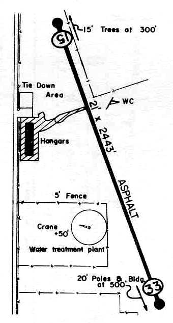
Shiloh Airport was described in the 1971 Flight Guide as having a single 2,350' paved Runway 15/33.
A 1972 aerial view depicted Shiloh Airport as having a single paved northwest/southeast runway.
A hangar & a dozen light aircraft were on the west side of the field.
According to Orville Mather, “When Dallas Garland Airport closed in 1972,
Texas United Flyers (owned by Ferris O'Dell) moved out there [to Shiloh Airport]
and overnight it became a busy little airport.”
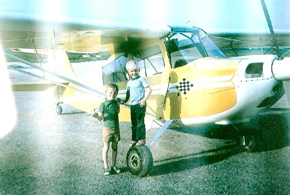
A 1972 photo of Bobby Moorehead & his brother in front of a Citabria at Shiloh Airport.
A 1973 DFW Terminal Control Area Chart (courtesy of Fred Fischer)
depicted Shiloh as having a single north/south runway.
David Kinney recalled, “During the 1970s I flew into Shiloh Airport at lot.
It was a VERY active airport with over 40 airplanes based there.”
Al Benzing recalled "I worked there as a CFI from 1976-79.
While I was there, there was one FBO/Flight School, 'Texas United Flyers', owned by Farris O'Dell.
He had a larger operation at Dallas Love at the same time.”
The earliest aeronautical chart depiction which has been located of Shiloh Airport
was on the 1978 DFW Sectional Chart (courtesy of Ray Brindle).
The 1978 TX Airport Directory (courtesy of Chris Kennedy)
depicted Shiloh Airport as having a single 2,443' asphalt Runway 15/33,
with a single hangar along the west side of the field.
The operator was listed as Texas United Flyers,
and the manager was listed as Farris O'Dell.
Al Benzing recalled "In the spring of 1978, a new owner took over, with new C-152s & 172s,
but I don't know how long they were in business."
"The airport had a 'narrow' runway,
with the southeast end of the runway being downhill (and not visible from the [opposite] end).
I recall it was about 2,370' long with HUGE High Tension power lines on the southeast end.
They looked especially large when taking off with a heavy PA28-140."

The last photo which has been located showing Shiloh Airport in operation was a 1979 aerial view.
The field was obviously quite popular right up to the very end,
with dozens of light aircraft parked on the west side of the field.
Bobby Moorehead recalled, “When a developer shot down the expansion of the airport my father [Royce Moorehead] decided to become an A&P.
He stayed at Shilo until it closed in 1979... [it] was closed by the Richardson City Council.”
Shiloh Airport was no longer listed in the 1985 TX Airport Directory
nor depicted at all on the 1986 USGS topo map.
Tim Vasquez recalled, "Rockwell International built here in the early 1980s,
but the facility was about 1,000' north of the old airport & it remained on mostly vacant land.
Even in 1987 the airfield pavement was still intact & accessible on a cul-de-sac.
I used to see radio-controlled airplane enthusiasts flying their planes there on weekends.”
A 1989 aerial view showed that the hangar had been removed,
and a new road had been built across the runway, but the majority of the runway remained intact.
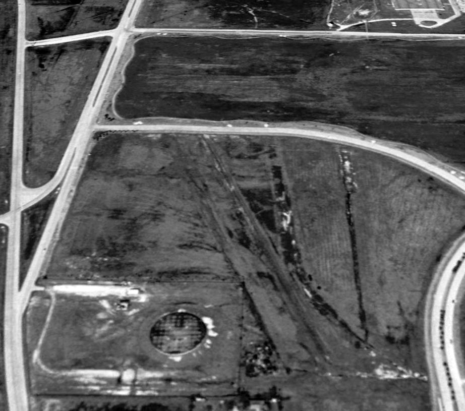
A portion of the southern half of the former Shiloh Airport runway was still visible in a 1995 USGS aerial view looking north.
However, a new road, Research Drive, had already been built across the middle of the runway.
Tim Vasquez recalled, "Sometime in the early or mid 1990s a high-tech firm built directly on the airfield, obliterating it.”
Robert Howington reported in 2005 that the building covering the site of the airfield
belongs to Fujitsu Network Communications.
In quite an ironic development, Bobby Moorehead (son of former Shiloh Airport owner Royce Moorehead) reported in 2010,
“I currently live in the development that caused its demise.”
A 2016 aerial view looking north showed no trace remaining of Shiloh Airport.
The site of Shiloh Airport is located west of the present-day intersection of Telecom Parkway & Research Drive.
___________________________________________________
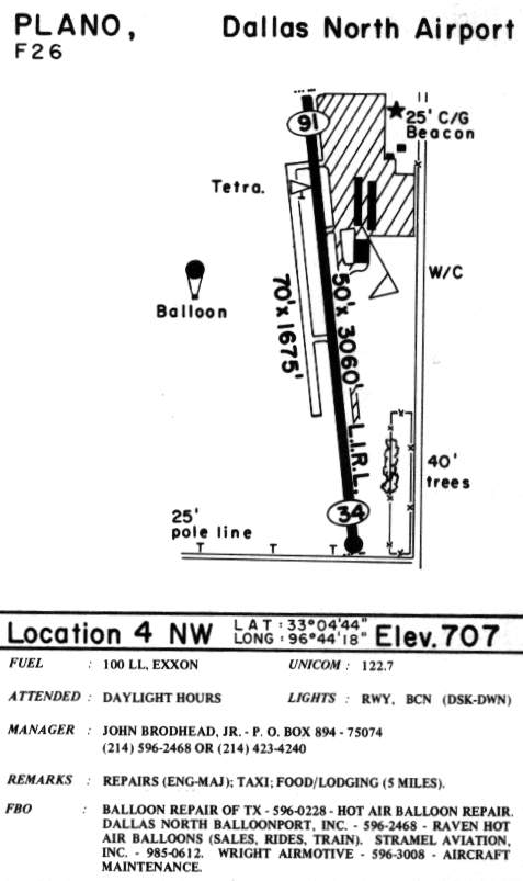
Dallas North Airport (F26), Plano, TX
33.08, -96.739 (North of Dallas, TX)
Dallas North Airport, as depicted on the 1968 USGS topo map.
The Dallas metro area used to be blessed with an abundance of small general aviation airports.
Unfortunately, that is not the case anymore, as a large number of them have been swallowed up by rapid development.
An example is Dallas North Airport.
No airfield was yet depicted at this location on the 1964 DFW Local Aeronautical Chart (courtesy of John Price).
Royce Barron recalled, "John Brodhead opened Dallas North Airport in 1968
after closing Highland Park Airport, which he also owned."
The earliest depiction which has been located of Dallas North Airport was on the 1968 USGS topo map,
which depicted a single unpaved northwest/southeast runway, labeled “Landing Strip”,
with 2 small buildings along the northeast side.

The earliest photo which has been located of Dallas North Airport was on a 5/1/68 USGS aerial photo.
It depicted a single northwest/southeast runway, perhaps still under construction.
A single T-hangar sat near some other buildings on the northeast side,
but there were not yet any aircraft visible on the field.
The earliest aeronautical chart depiction of Dallas North Airport which has been located
was on the 1969 DFW Sectional Chart (courtesy of Ron Myres).
It depicted Dallas North as having a single paved 3,000' north/south runway.
The 1973 DFW Terminal Control Area Chart (courtesy of Fred Fischer)
depicted Dallas North as having a single paved north/south runway.
David Kinney recalled, “Dallas North... had over 60 airplanes based there.”
Dallas North Airport was depicted on the 1978 DFW Sectional Chart (courtesy of Ray Brindle)
as having a single 3,100' north/south paved runway.
Tim Hauter recalled, "The owner of the airport was John Brodhead, Sr. ,
who also owned the Highland Park Airport as well.
Mr. Brodhead, his wife Lucille, son and daughter-in-law ran the FBO operation
that included a Cessna flight school."
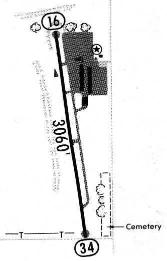
By 1981, an airfield diagram (courtesy of Steve Cruse)
depicted Dallas North Airport as having a 3,060' paved Runway 14/34, with a parallel taxiway,
and a paved ramp on the northeast side of the field with three hangars.
Dallas North was listed in the 1982 AOPA Airport Directory (courtesy of Ed Drury),
which described the field as having a single 3,100' asphalt Runway 16/34.
The operators were listed as Dallas North Aviation, Wright Airmotive, and Linsley Avionics.
Bob Bledsoe recalled, "A friend of mine, Monte Ditmer, had a Yellow Peril Navy biplane
he used to fly out of the North Dallas Airport on Coit.
He didn't have a driver's license so he used to ride his bicycle to the airport."
Royce Barron recalled, "I worked at Dallas North Airport in Plano from 1982-84.
The airport was owned by John Brodhead, a very friendly & charitable man.
His wife, Lucille was the bookkeeper/office manager for the airport.
Mr. Brodhead’s son Randy & daughter-in-law Cathy ran the airport during the week.
Mr. Brodhead had two beautiful granddaughters whom he absolutely adored.
One was named Jaran & the other, I believe, was named Kristin.
He carted them around the airport in a golf cart."
"The airport was a 'family' business & anybody who worked at the airport,
or worked for Mr. Brodhead, was considered family.
Mr. Brodhead had a gentleman named Jerry Carpenter work for him at the airport every Sunday.
In exchange, Mr. Brodhead would give Mr. Carpenter all sorts of valuable tools & equipment
and allowed Mr. Carpenter’s son to live in a house adjacent to the airport."
"Randy Brodhead was a hot-air balloon pilot & ran a Raven Balloons dealership
as well as Dallas North Balloonport, a balloon ride service, out of Dallas North.
Prior to becoming a balloon pilot, Randy ran a Cessna dealership & a flight school out of the airport.
The flight school was sold to Dan Stramel & became Stramel Aviation."
"During 1984, Mr. Brodhead started work on expanding the runway all the way north to Hedgecoxe Road
(a dirt road at the time) in anticipation of a commuter airline starting service to Dallas North.
The plans for the commuter airline never got off the ground
and the runway lengthening project was not completed.
Dallas North was served by a helicopter airline during the early 1980s
but I’m not sure whether or not it was scheduled or how long it was in service."
John Bixby recalled in 2003, "F26 was a great little airport, my very first job was here back in 1984,
gassing planes, mowing the grass, being an airport bum in general."
The 1985 TX Airport Directory (courtesy of Steve Cruse)
depicted Dallas North as having a 3,060' paved Runway 16/34.
A parallel grass runway was located to the west, along with a balloon operating area.
A paved ramp area was northeast of the runway, on which sat 3 hangars.
The operators were listed as Balloon Repair of TX, Dallas North Balloonport Inc.,
Raven Hot Air Balloons, Stramel Aviation Inc., and Wright Airmotive.
According to Ted Mastenbrook,
"Dowling Wright was Wright Airmotive. I used him for some work on my aircraft.
The TX Instruments flying club was once based there before moving to McKinney."

A 1988 picture of Dallas North Airport by John Bixby, taken while landing on Runway 34 in a Cessna 172.
John Bixby recalled in 2003, "I later instructed there for Stramel Aviation early 1988 through late 1989."
Royce Barron recalled, "Dallas North closed in 1991 or 1992.
Mr. Brodhead passed away soon after the airport was closed."
A circa 1992 view of Dallas North Airport by Ed Jerue,
taken after the field was closed & shortly before it was redeveloped,
showing the Cessna sign & the Stramel Aviation operations building.
The sign read "Stramel Aviation Pilot Center Cessna".
The operations building was relocated to the east & became the builder's office for the development.
A circa 1992 photo by Ed Jerue looking south from Hedgecoxe Road,
showing the runway (already crossed by a drainage pipe).
Ed Jerue lives in the development that occupies the land adjacent to the site of Dallas North Airport to the west.
He reports that "In the spring of 1991 I drove down the runway,
at that time there was a big X painted in the middle of the runway.
There was only one building at the site, I believe the operations building, all hangars were gone.
I would guess that the airport was bulldozed in circa 1993."
A 1995 aerial photo of the site of the former airport showed that it had been completely covered by housing,
with not a trace of the former airfield remaining at the site.
Royce Barron recalled, "Ironically, the housing development that is built on the airport site
has many airport-themed street names such as LaGuardia, Stapleton, and Heathrow."
The former hangar of Dallas North Airport, now relocated to Skydive Dallas, in Whitewright.
Jerry Felts reported in 2003 that "Actually, a large piece of the airport still exists today & is in daily use.
In 1992, I helped move the main hangar from Dallas North to Tri County Airport in Whitewright
and re erected it to use for our skydiving operation.
It is still a very successful operation & the hangar is large enough to store a Twin Otter,
Cessna Caravan, and two Cessna 182s.
In addition to that, it has training rooms, bunk rooms, cafe, riggers loft, and manifest/office space."
A 2016 aerial view looking north showed no trace remaining of Dallas North Airport.
The airport site is located northwest of the present-day intersection of Custer Road & Legacy Drive.
___________________________________________________
Highland Park Airport, Dallas, TX
32.92, -96.774 (North of Downtown Dallas, TX)
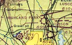
Highland Park Airport, as depicted on the March 1947 Dallas Sectional Chart (courtesy of Chris Kennedy).
This small general aviation airport was apparently built at some point between 1945-47,
as it was not yet listed among active airfields in the 1945 AAF Airfield Directory (courtesy of Scott Murdock).
The earliest depiction of Highland Park Airport which has been located
was on the March 1947 Dallas Sectional Chart (courtesy of Chris Kennedy).
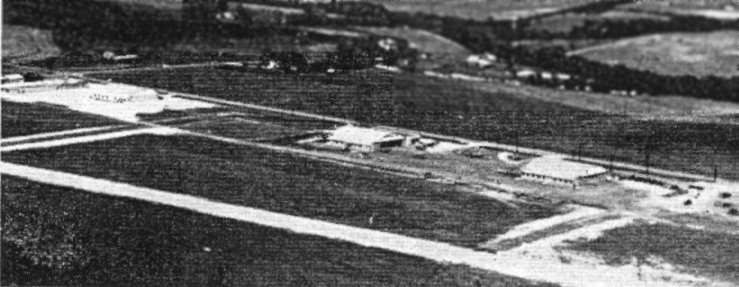
An aerial view of Highland Park Airport from an article entitled "Private Airports"
in the May 1947 issue of the Dallas Chamber of Commerce Magazine (courtesy of Jeff Ferguson).

An advertisement for Hicks Aviation Service
from the May 1947 issue of the Dallas Chamber of Commerce Magazine (courtesy of Jeff Ferguson).
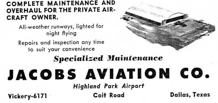
An advertisement for Jacobs Aviation
from the May 1947 issue of the Dallas Chamber of Commerce Magazine (courtesy of Jeff Ferguson).
Highland Park Airport was described extensively in an article entitled "Private Airports"
in the May 1947 issue of the Dallas Chamber of Commerce Magazine (courtesy of Jeff Ferguson).
"One of the newest & most modern fields for private flyers
and the only one in the Dallas area equipped for both day & night flying is the Highland Park Airport,
owned by J.A. Hudson & J.C. Lindsey and laid out on a 180 acre tract on Coit Road,
1 ½ miles North of Northwest Highway.
Four Large hangers provide a total 53,700 square feet of shelter for stored panes.
Some 105 planes are permanently based at the field.
Two runways (2,420' & 1,800' in length) accommodate medium size, multi-engined craft.
An all weather asphalt topping covers all runways & aprons, and hard-surfaced taxi-strips connect all individual hangars.
Modern flush-mounted lights along both runways permit night flying.
Six different businesses, employing a total of 41 persons, are located on the field.
They are: Southern Air Sales Corporation, distributor of Fairchild aircraft;
Jacobs Aviation Company, Waco aircraft distributor & repair service;
Park Citys Aero Service, distributor of Trimmer Amphibians;
Hicks Aviation Service, distributor of Ercoupe planes;
Weatherly-Campbell Aircraft, distributors of Luscombe & Bellanca planes & manufacturers of the four-passenger Colt Airplane;
and Highland Flying Service, flight training & repair service."
The Dallas Chamber of Commerce Magazine continued, "The shops of Weatherly-Campbell Aircraft at Highland Park Airport are equipped,
staffed and licensed to undertake practically every kind of operation
in aircraft metals, fabrics, and plywoods from a small patch job
to building aircraft of completely new design such as the Weatherly-Campbell Colt.
Starting from the basic blueprints of a design by Don Luscombe,
Weatherly-Campbell has redesigned & engineered the Colt for production
as an all-metal, four-place, executive-type plane,
the Colt is designed for a short takeoff run, rapid climb, and 700 mile range
with four passengers & 120 pounds of baggage at an average cruising speed in excess of 150 miles per hour.
The Colt is still in the experimental stage."
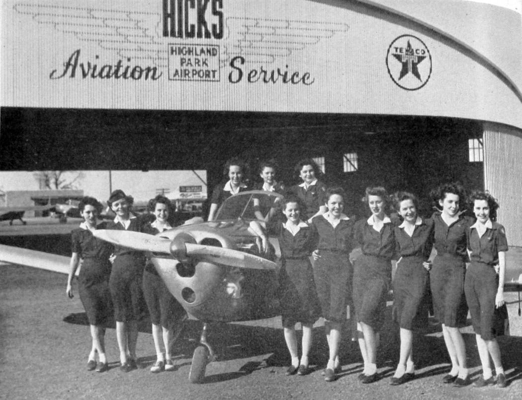
An undated photo of the Flight Five Wing Scouts posing with an Ercoupe in front of Highland Park Airport's Hicks Aviation Service Hangar
from the 1947 North Dallas High School Viking Yearbook (courtesy of Danny Linn).
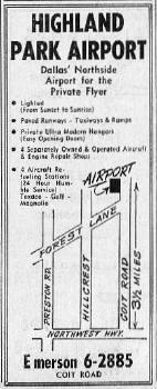
An advertisement for Highland Park Airport from the 1948 Greater Dallas Telephone Directory.
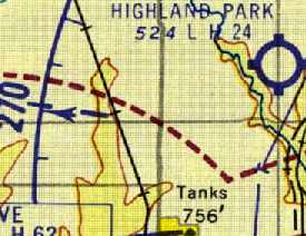
The September 1954 DFW Local Aeronautical Chart (courtesy of David Brooks)
depicted Highland Park Airport as having a 2,400' hard surface runway.
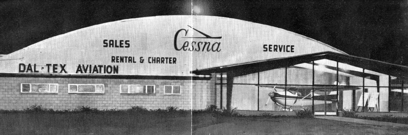
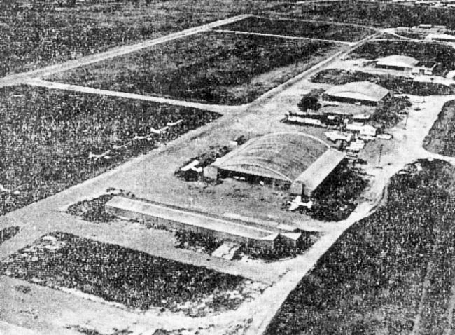
An undated photo of the Dal-Tex Aviation hangar at Highland Park Airport, from a July 1958 article (courtesy of Don Valentine).
Don Valentine recalled, “Dal-Tex Aviation [was] the Cessna dealer at Highland Park Airport.
My stepfather Dowling Wright was the chief mechanic at Dal-Tex Aviation & it was founded by his brothers H.O. & T.O. Wright.”
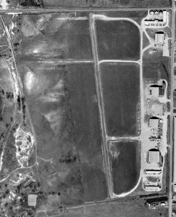
A 1958 aerial view depicted Highland Park Airport as having a paved northwest/southeast runway
and an unpaved crosswind runway.
A total of 7 hangars were along the east side of the field,
around which were visible a dozen light aircraft.
The 1959 USGS topo map depicted Highland Park Airport as having a paved northwest/southeast runway,
a parallel taxiway, and a building on the east side of the field.
The last photo which has been located of Highland Park Airport was an undated aerial view looking northwest by Tom Dillard from a 1960 article.
It depicted several planes & a row of hangars along the east side of the field.
Highland Park Airport was listed among active airports in the 1962 AOPA Airport Directory,
which described the field as having two asphalt runways (2,380' Runway 18/36 & 1,700' Runway 9/27).
The operator was listed as Corry & Brodhead Aviation Co.
According to Royce Barron, Highland Park Airport was owned by John Brodhead.
Bill Sterling recalled that "Along 1960-61 Bailey [Duncan, his pastor]
began to patronize John Broadhead’s operations at Highland Park Airport.
Later in 1963 after I had begun formal training at Addison,
I moved over to train under Broadhead’s operation.
At that time Runway 17/35 had been shortened by some three or four hundred feet
by the construction of Interstate 635/LBJ Freeway across the north end.
Rather tight for a pre-solo student to land a straight tail Cessna 172 within 1,800’ or so.
John took great interest in his students.
He knew the airport would be short lived,
so he began working toward building a new one in the Plano area (North Dallas Airport)."
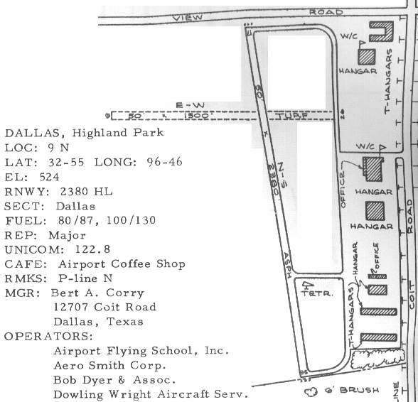
The 1963 TX Airport Directory (courtesy of Steve Cruse) depicted a slightly different runway configuration,
with the crosswind runway being depicted as a 1,500' grass Runway 8/26.
The operators were listed as Airport Flying School Inc., Aero Smith Corp.,
Bob Dyer & Assoc., and Dowling Wright Aircraft Service.
The Airport Manager's address was 12707 Coit Road.
A total of seven hangars & an office building were depicted along the east side of the airport,
situated on a large paved ramp.
John Price recalled, “I learned to fly at Highland Park's Airport Flying School (owned by Bert Corey) in 1965.
I sold my car to get the money to pay for flying lessons.”
Jim Sparr recalled, “In 1965-67 I was a CAP cadet with Irving Composite Squadron.
I can confirm that we were still flying L-16 Aeronca Champs out of both Park Cities & Highland Park during that period.”
Highland Park Airport was still depicted on a 1966 Conoco DFW road map.
Note the depiction of the proposed alignment of the adjacent 635 Freeway,
the construction of which would soon spell the end for the airport.
Spike Cutler recalled that Highland Park Airport "was still open after LBJ Freeway (I-635) opened in about 1968.
I recall my father taking me there when the airport was still open, but fading fast."
According to Royce Barron, Highland Park Airport owner John Brodhead
"told me that he had to close this airport because I-635 / LBJ Freeway had taken off the northern part of the runway.
Given that he opened Dallas North in 1968,
I would guess that he closed Highland Park sometime prior to 1968."
By the time of the 1969 DFW Sectional Chart (courtesy of Ron Myres),
Highland Park Airport was no longer depicted at all (not even as an abandoned airfield).
Heath Coker recalled, "My Dad bought the land when he was a partner of Trammel Crow
and they developed it into the office park called Park Central.
We often raced up & down the old runway before there were buildings there."
A 1972 aerial view showed that all of the hangars had been removed.
Two roads had been built over the runway,
but the majority of the runway length remained intact.
A 1979 aerial view showed that the remaining portions of runway were gone,
with several large buildings occupying the property.
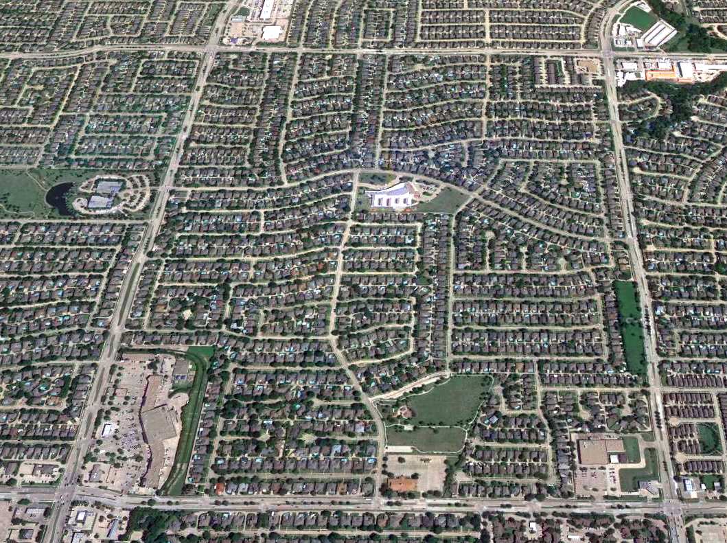
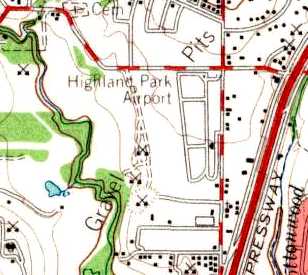
A 2016 aerial view looking north shows the site of Highland Park Airport had been densely redeveloped.
However, faint traces of the former airport may still be discerned.
As pointed out by Keith Wood, “the development which covers the southern half of the site
follows the alignment of the runway & taxiway.
An original eastern boundary of the parking lots follows the alignment of the taxiway (which was at an angle to the runway).
The ramp area is of different colors than the main development.”
Highland Park Airport was located at the present-day intersection of Banner Drive & Coit Road.
___________________________________________________
North Dallas Jetport / Frisco Airport (DDJ), Frisco, TX
33.145, -96.853 (North of Dallas, TX)
Frisco Airport, as seen in a 12/4/89 USGS aerial photo.
Photo of the airport while in use has not been located.
No airfield was yet depicted at this location on a 11/13/82 USGS aerial photo.
This airport was built with private money in 1986 during the 1980s development boom.
Its original name was the "North Dallas Jetport".
Some sources indicate Ross Perot was involved in the initial business venture which constructed the airport
(Ross's Company, EDS, has its headquarters just down the road).
The airport wound up on the block in a failed savings & loan deal.
Kent Hope, managing partner of HIP, an Addison development partnership, bought the property,
then in receivership, from the Federal Deposit Insurance Corp.
But it was apparently never able to reach its potential, due to the fears of neighbors of potential noise.
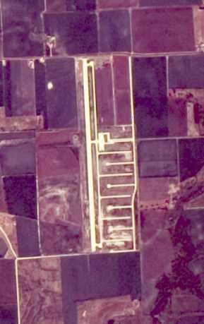
The earliest depiction which has been located of the Frisco Airport was on a 12/4/89 USGS aerial photo.
It depicted Frisco as having a single 5,800' paved Runway 17/35 with a parallel taxiway.
A ramp was located on the east side of the field,
along with multiple taxiways which extended toward what were planned to be the location of private T-hangars.
There did not appear to be any buildings on the site.
No airfield was yet depicted on the 1991 USGS topo map.
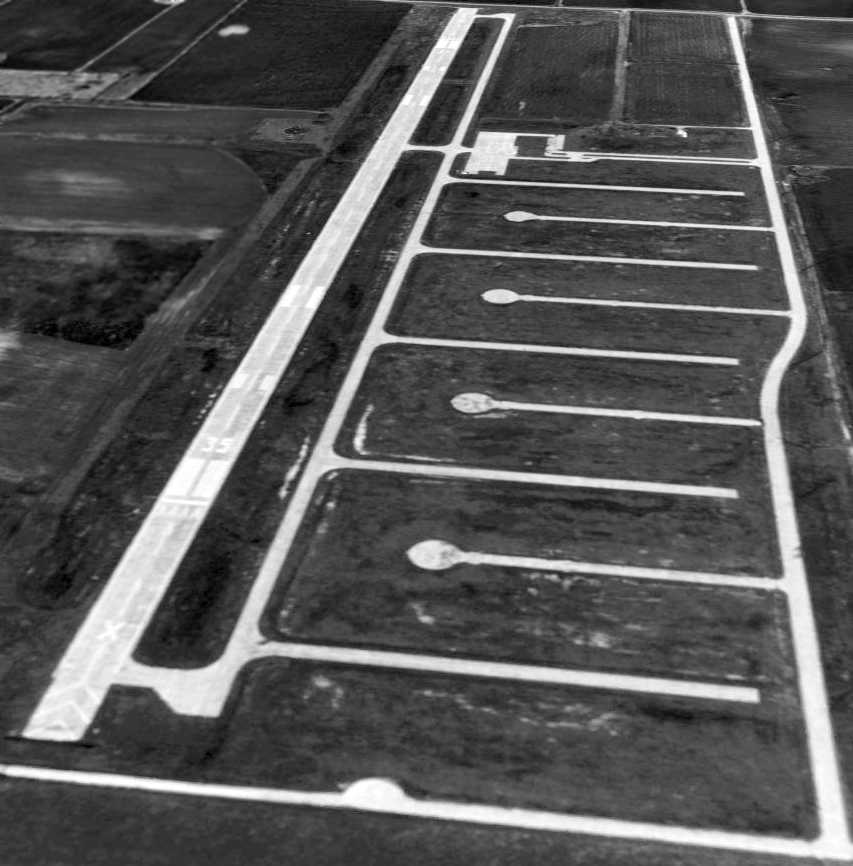
A 3/17/95 USGS aerial photo looking northwest depicted Frisco Airport as having a single 5,800' paved Runway 17/35, which was still marked as an active runway, with a parallel taxiway.
A ramp was located on the east side of the field,
along with multiple taxiways which extended toward what were planned to be the location of private T-hangars.
There did not appear to be any buildings on the site.
Frisco Airport was depicted on the 1995 DFW Terminal Area Chart, with the label “under construction”.
In 1996, plans were being set in motion to develop Frisco's little-used airstrip
into a full-service commercial airport, the Frisco Jetport.
The deal might have transformed the strip into a North Texas corporate aircraft thoroughfare.
Construction was planned to begin in 1996.
Twenty-year plans called for a 7,000' runway with parallel taxiways,
a terminal, fixed-based operator facilities, landing & navigational aids,
private hangars & sites for commercial & industrial development, all of which would cater to corporate clients.
But those plans were never realized.
Frisco Airport's eventual configuration consisted of a single 5,800' paved Runway 17/35 with centerline lighting,
a parallel taxiway with centerline lighting, an ILS, and the beginnings of RVR equipment.
As of 2000, all of that infrastructure was sitting completely idle,
with its only use being for practice landing approaches by local airplanes & helicopters.
Frisco Airport was still listed as an active airfield in the 2001 AOPA Airport Directory (according to David Brooks).
Of Frisco Airport, Spike Cutler recalled, "Ah, the lost opportunity!
I had a rather heated debate with a friend who was also a member of the Frisco City Council
when they were negotiating to buy the airport, for the purpose of shutting it down.
She could not fathom that an airport could have any redeeming qualities.
My father (a broker) tried valiantly to make a deal come together to get the almost-finished airport opened & operating,
back in 1989-1990; we went there several times & viewed the property."
Spike continued, "I did get to land there a couple of times during the brief time it was open to air traffic
(sorta spooky really, a big, nice concrete runway with taxiways & no infrastructure, save one steel building).
I think it was really only opened so that the nearby residents
would apply pressure on the City of Frisco to end the noise - by buying the airport.
Which they did."
Spike continued, "My dad may still have the slick promotional packet that was put together on the project.
It was nearly finished (as you can see) when Franklin Savings of Austin failed,
thus killing the working capital for the completion.
All (and I mean all) it lacked were buildings -
the runway lighting, ILS for Runway 17, wind sock, a PAPI, all were there.
It was burdened with many poor choices, as well,
including being bound at both ends by roads, the ILS array too close to the southern end,
very large power lines very near by on the east.
Still, what coulda been, for an area which sure could use it.
Too many NIMBY's.
I try to fly by kinda low from time to time, just to spite 'em (joking, really)."

The last photo located showing Frisco Airport still intact was a 1/31/01 aerial view looking northwest.
All of its extensive aviation infrastructure was still in place, but the runway was marked with closed-runway yellow “X”s.
A building had been added to the east of the runway at some point between 1995-2001.
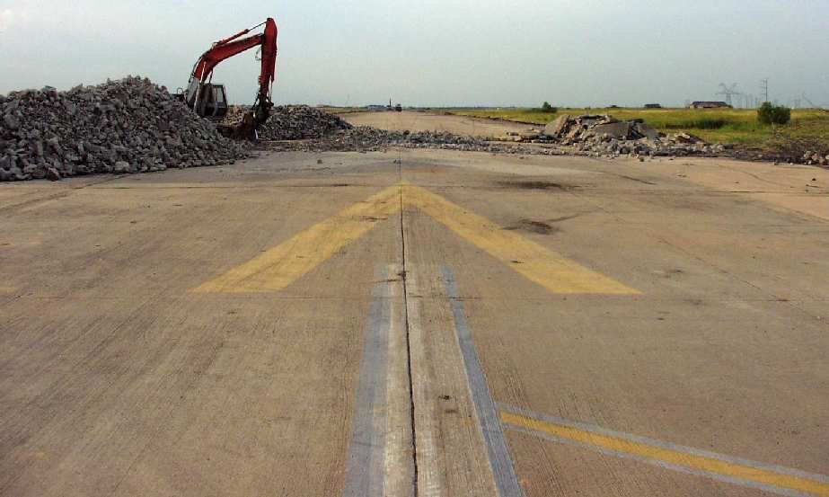
A 2002 photo by Tim Siemens of Frisco's runway in the process of being removed.
According to Tim Siemens (an airfield engineer who visited Frisco Jetport in early 2002),
a concrete crusher was on the site, removing the runway.
According to Siemens, "There were a number of serious design flaws.
The airport clearly did not meet FAA criteria & had a number of serious design flaws.
Whoever laid it out didn't have a firm grasp of airfield planning & engineering.
My guess is that the developer hired his usual architects that he'd used on business parks
and asked them to design an airport.
These individuals mismatched a number of elements. Sad but true."
Paul Freeman visited the site of Frisco Airport in mid-2002,
to find much the same sight as witnessed by Siemens -
the runway pavement was being actively removed.
The sole building at the site was being reconfigured as a Frisco Fire Station.
Spike Cutler reported in 2003, "I happen to have flown over Frisco at about 1,000' AGL the day before yesterday,
and it looks like... well, like an airport where they took up all the concrete. Go figure!"
A 2003 aerial view showed that much of the airport's pavement had been removed.
Strangely, the new building to the east of the runway had been removed at some point between 2001-2003,
and a Frisco fire station with a helipad had been added just to the northeast.
Frisco Airport was depicted as an abandoned airport on the 2003 Sectional Chart.
A 2005 aerial view showed the airport property to remain largely intact, though deteriorating.
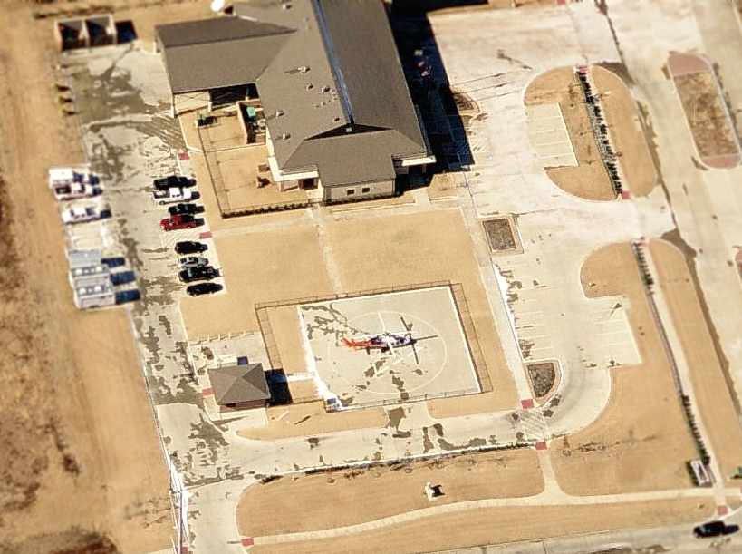
A circa 2006 aerial view looking west showed the aviation role which has returned to the Frisco Airport property:
a medivac Agusta A109 parked on a helipad east of the new Frisco fire station.
Matt Murphey reported in 2007 that the helicopter at Frisco “is an Agusta A109 twin-engine helicopter
operated by Careflite & the building it is parked next to is a Frisco Fire Station where it is based.
The fire station is located on the former airport grounds.”
However, as of 2007 the FAA Airport/Facility Directory data did not have any listing for a heliport at the location.
A 2006 aerial photo showed housing construction covering the southern end of the runway site.
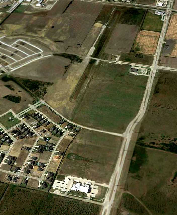
An 8/2/12 aerial view looking northwest showed the site of Frisco Airport to have been radically transformed,
with housing covering the southern third of the runway, which remained somewhat recognizable but considerably deteriorated on its northern portion.
Several turnaround pads were still recognizable on the southeastern portion of the airport site.
The site of Frisco Airport is located southwest of the intersection of Route 720 & Legacy Drive,
one mile west of the town of Frisco.
Thanks to Chicago Express pilot Alan Courtney for pointing out this field.
See also:
Dallas Business Journal, 9/20/96.
Dallas Business Journal, 10/4/96.
____________________________________________________
Since this site was first put on the web in 1999, its popularity has grown tremendously.
That has caused it to often exceed bandwidth limitations
set by the company which I pay to host it on the web.
If the total quantity of material on this site is to continue to grow,
it will require ever-increasing funding to pay its expenses.
Therefore, I request financial contributions from site visitors,
to help defray the increasing costs of the site
and ensure that it continues to be available & to grow.
What would you pay for a good aviation magazine, or a good aviation book?
Please consider a donation of an equivalent amount, at the least.
This site is not supported by commercial advertising –
it is purely supported by donations.
If you enjoy the site, and would like to make a financial contribution,
you
may use a credit card via
![]() ,
using one of 2 methods:
,
using one of 2 methods:
To make a one-time donation of an amount of your choice:
Or you can sign up for a $10 monthly subscription to help support the site on an ongoing basis:
Or if you prefer to contact me directly concerning a contribution (for a mailing address to send a check),
please contact me at: paulandterryfreeman@gmail.com
If you enjoy this web site, please support it with a financial contribution.
please contact me at: paulandterryfreeman@gmail.com
If you enjoy this web site, please support it with a financial contribution.
____________________________________________________
This site covers airfields in all 50 states.