Abandoned & Little-Known Airfields:
Central Tennessee
© 2002, © 2016 by Paul Freeman. Revised 8/6/16.
____________________________________________________
Please consider a financial contribution to support the continued growth & operation of this site.
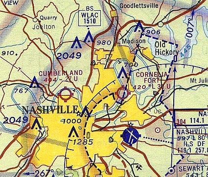
Blackwood Field (revised 12/12/15) - Cornelia Fort Airport / Cornelia Fort Airpark (revised 1/31/16) - Ft. Campbell Sky Drop Army Airfield (revised 5/16/15)
Gillespie Field / Cumberland Airport (revised 9/29/15) - Humpreys County Airport / Waverly Airport (added 2/24/13)
McConnell Field (added 8/6/16) - Middle Tennessee State College Airport (added 2/13/14)
Parsons Municipal Airport / Scott Field (revised 6/22/16) - Sky Harbor Airport (revised 2/15/14) - Smithville Intermediate Field (revised 12/12/15)
____________________________________________________
McConnell Field, Nashville, TN
36.14, -86.844 (West of Downtown Nashville, TN)
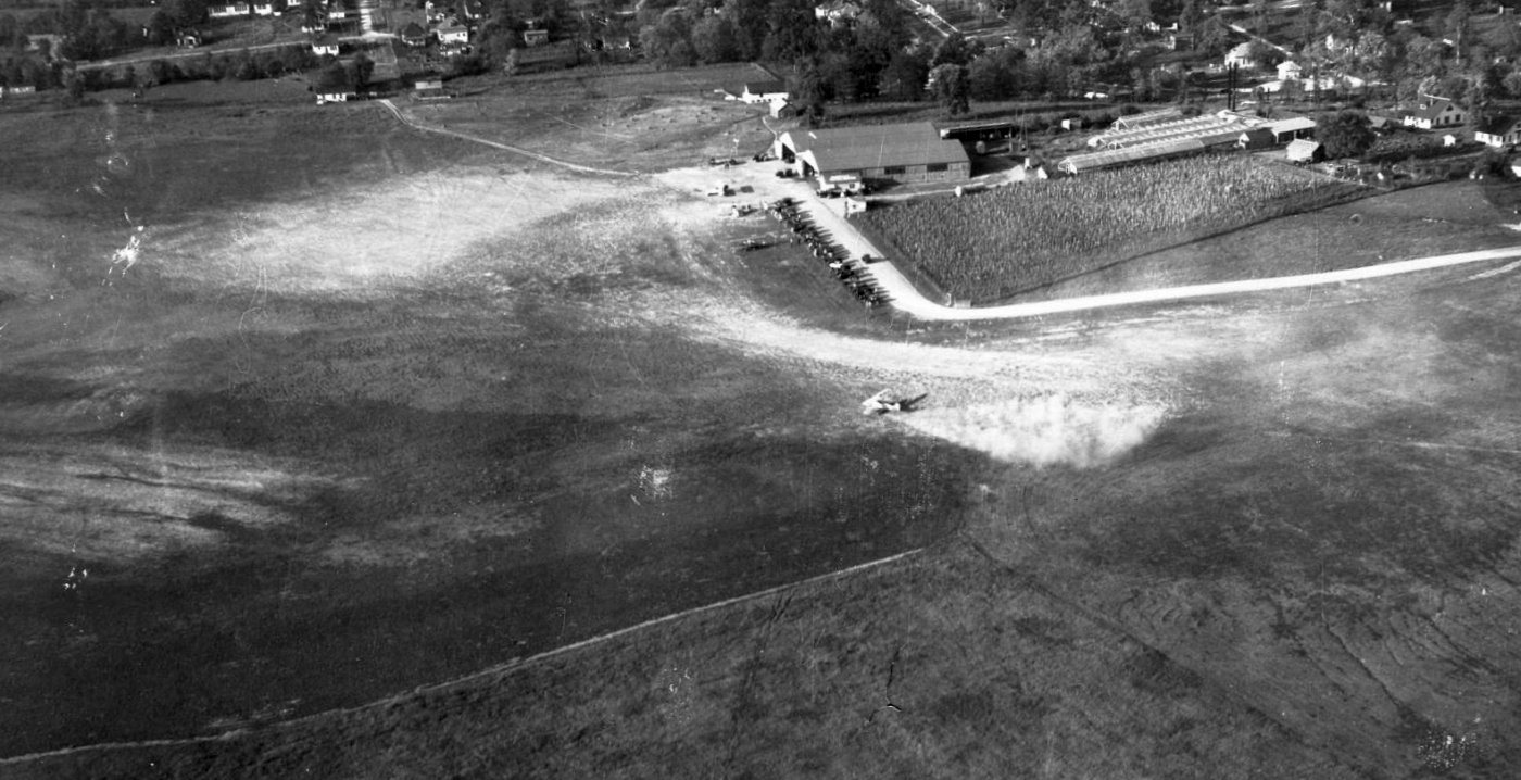
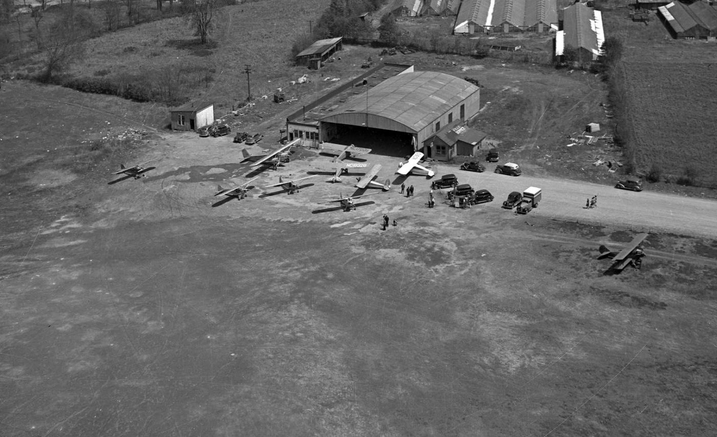
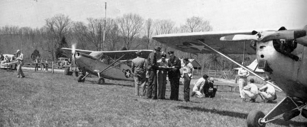
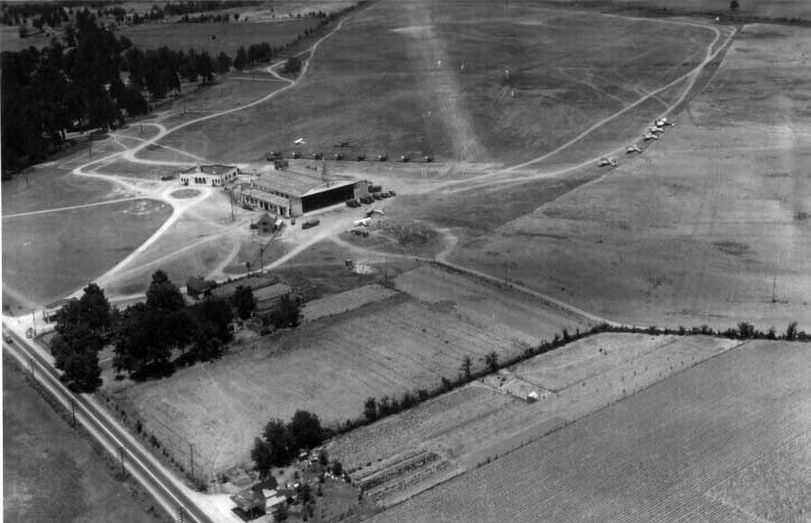
A 7/12/31 aerial view looking north at McConnell Field.
According to an article in the 12/21/03 issue of The Tennessean (courtesy of Marvin Maes),
the poor condition of the unpaved roads leading to Blackwood Field (and the cost of improving them)
removed the earlier Blackwood Field from contention for serving as a permanent airmail airfield for Nashville.
The increasing use of airmail also brought about the need for a closer airport to Nashville,
eventually leading to the establishment of McConnell Field (west of downtown Nashville) in 1927.
The 105th Observation Squadron relocated from Blackwood Field to McConnell Field in 1927.
The earliest depiction which has been located of McConnell Field was a 7/12/31 aerial view looking north,
which depicted several biplanes & a line of spectators in front of 2 hangars on the east side of a grass airfield.
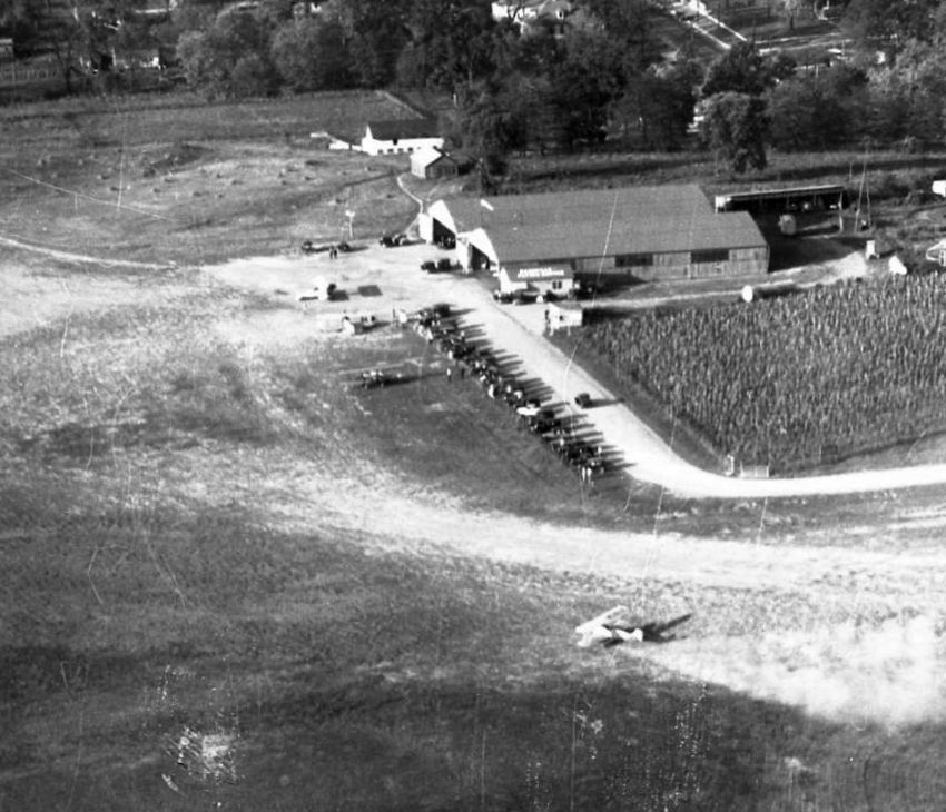
A closeup from the 7/12/31 aerial view showing biplanes, spectators, and the hangars of McConnell Field.
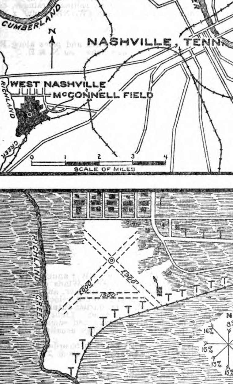
The Commerce Department's 10/12/31 Airway Bulletin depicted McConnell Field as having 3 unpaved runways,
with the longest being the 2,000' northeast/southwest & northwest/southeast strips.
A single building with a windsock was depicted on the southeast corner.
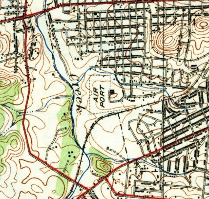
The earliest topo map depiction which has been located of McConnell Field was on the 1932 USGS topo map.
It depicted an L-shaped property outline, labeled simply as “Air Port”, with a single building on the east side.
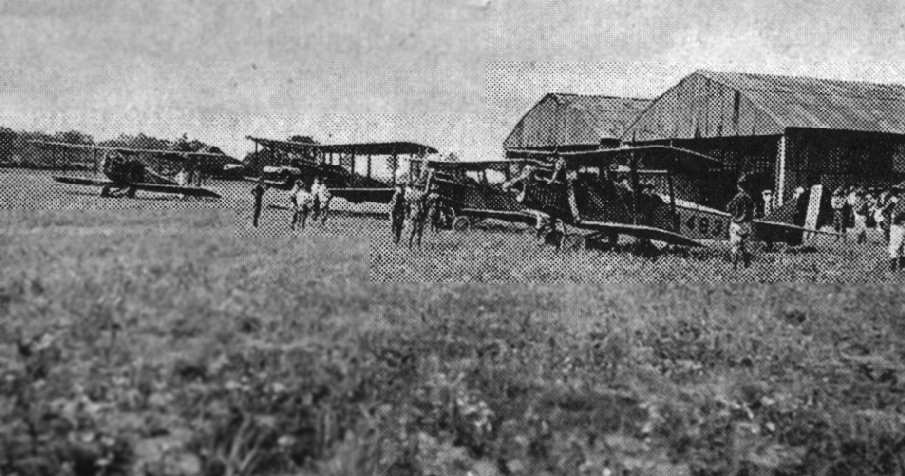
A 1938 aerial view looking east showing 10 monoplanes & biplanes in front of a single hangar at McConnell Field.
The second hangar visible in the previous photo had evidently been removed at some point between 1931-38.
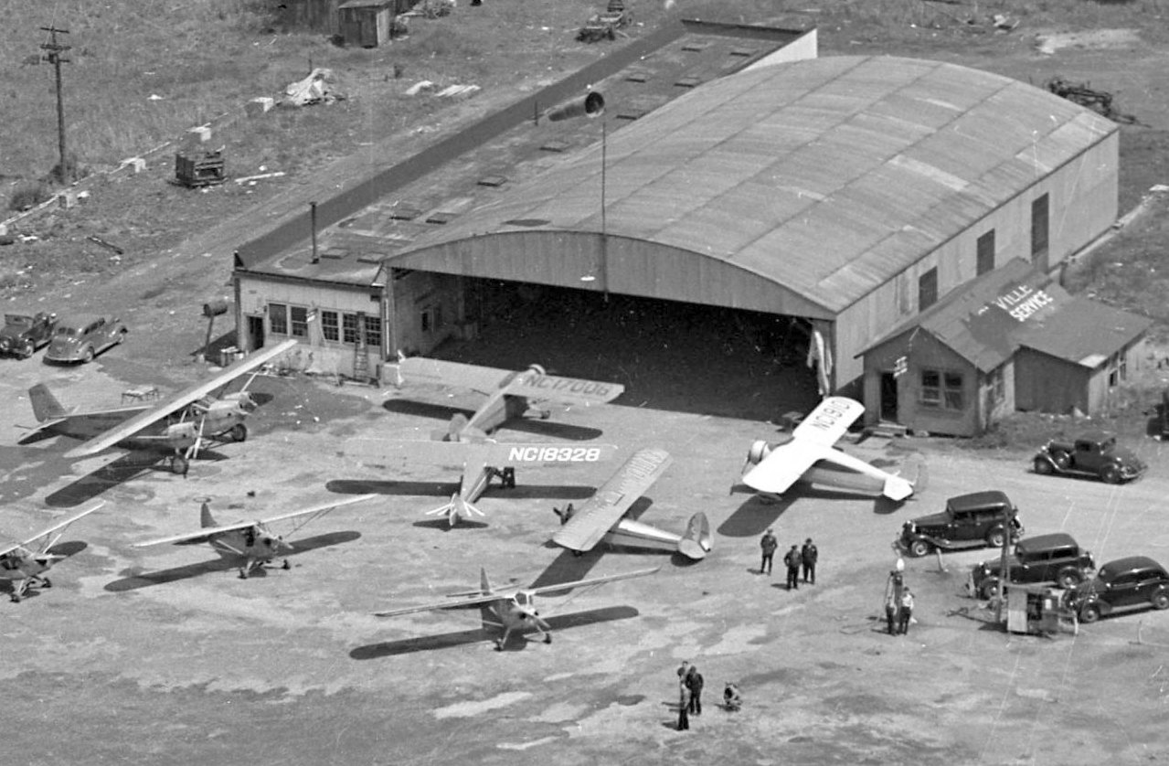
A closeup from the 1938 aerial view showing an arrangement of monoplanes & biplanes in front of the McConnell Field hangar.
The office to the right was marked “Ville Service”.
The 1943 USGS topo map continued to depict the McConnell “Air Port” in the same manner as the 1932 topo map.
The date of closure of McConnell Field has not been determined.
The 1954 USGS topo map depicted the “McCabe Park Golf Course” covering the site of McConnell Field.
An article in the 8/26/68 Tennessean described how a realtor had agreed to pay $60,000 for the 67 acre McConnell Field property,
with the understanding that several acres would be deeded to the city for school construction.
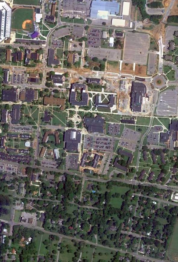
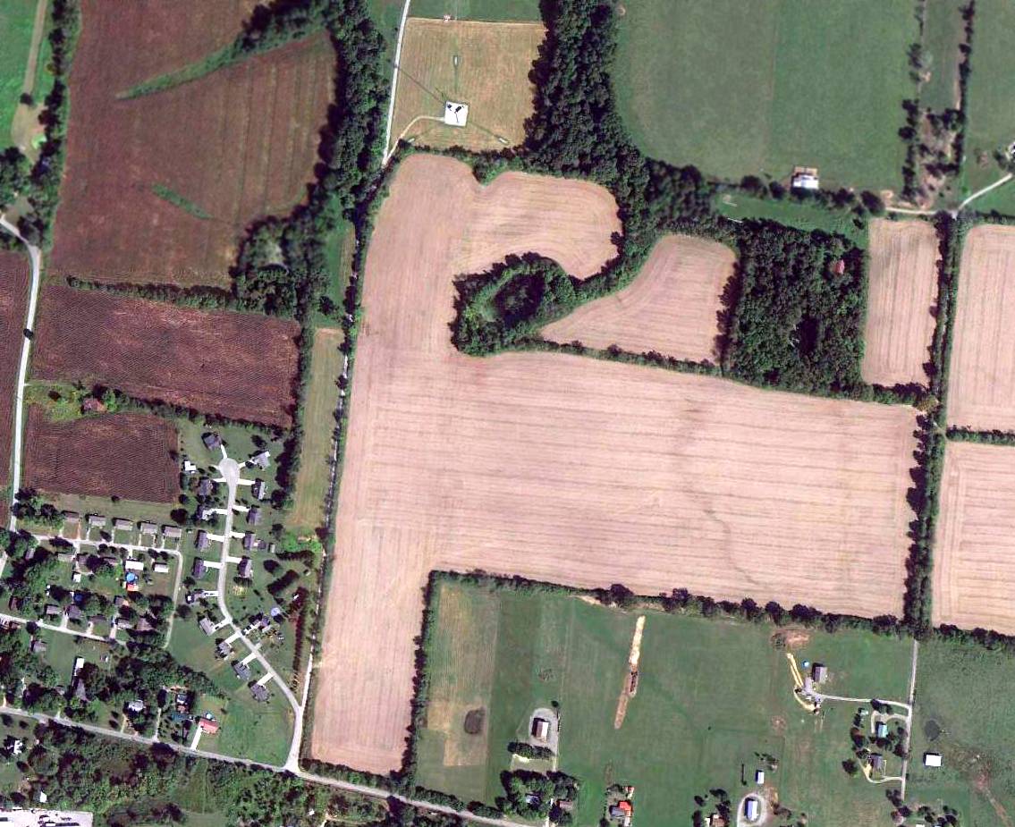
A 1992 aerial photo showed no trace of McConnell Field, with the property having become the McCabe Golf Course.
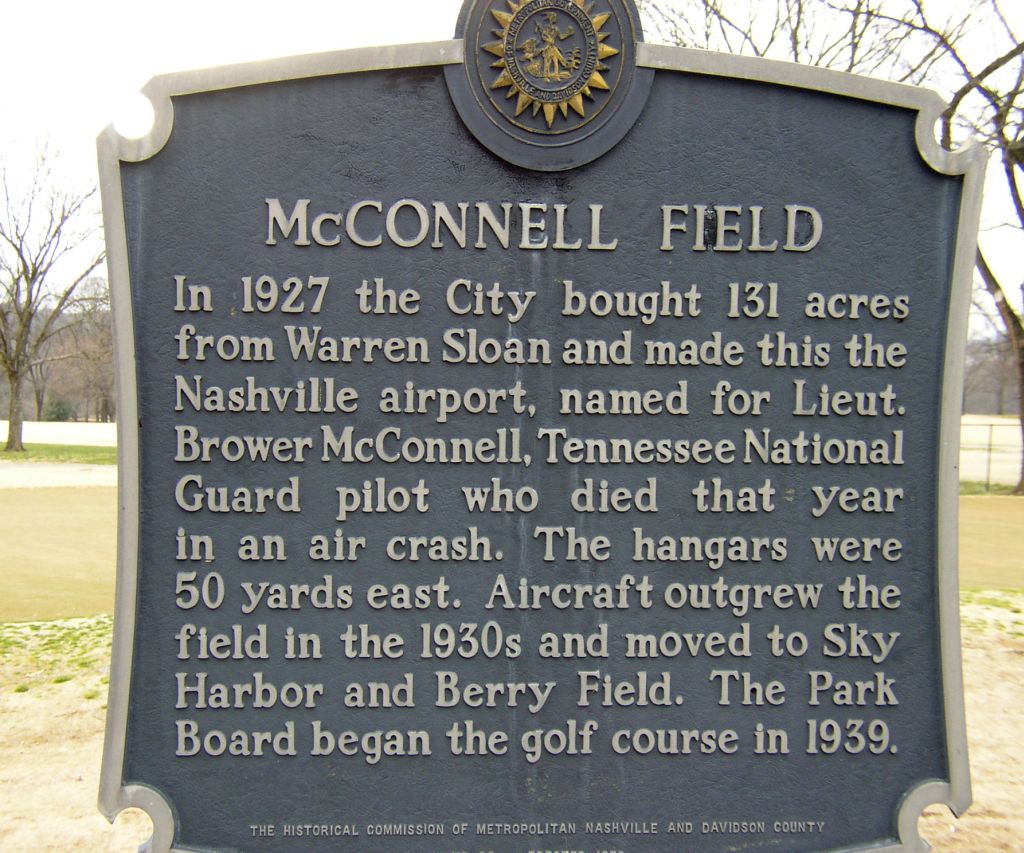
A 2007 photo by John Bailey of a historical marker at the site of McConnell Field.
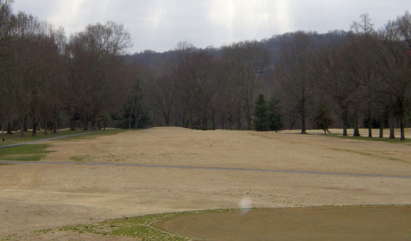
A 2007 photo by John Bailey looking south at the site of McConnell Field, now the McCabe Golf Course.
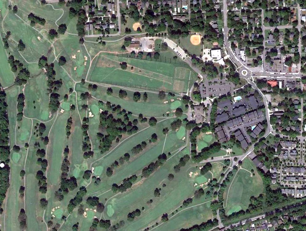
A 2015 aerial view of the site of McConnell Field, now the McCabe Golf Course.
The site of McConnell Field is located northwest of the western terminus of Murphy Road.
__________________________________________________
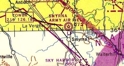
Fort Campbell Sky Drop Army Airfield, Big Rock, TN
36.63, -87.71 (Northwest of Nashville, TN)
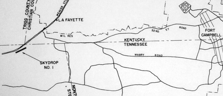
A circa 1954 map of the “Skydrop #1” airfield, showing its location relative to Fort Campbell (from the St. Louis National Personnel Records Center, courtesy of Ron Plante).
Ron Plante reported, “In late 1953, the Air Force & Army started a test called Operation Sky Drop
where Fort Bragg Army engineers built a dirt strip using equipment capable of being dropped by parachute.
A site was selected on the Fort Campbell reservation about 10 miles southwest of what was then Campbell AFB.
Once built, this strip was suitable for USAF C-119, C122, and C-124 cargo planes.
Construction work was completed in the spring of 1954.”
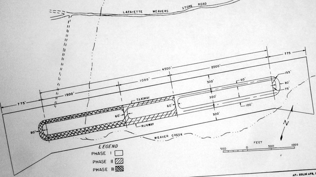
A circa 1954 map showing the 3 phases of construction of the Sky Drop airfield (from the St. Louis National Personnel Records Center, courtesy of Ron Plante),
consisting of a east/west runway with parallel taxiway, of progressively longer lengths.
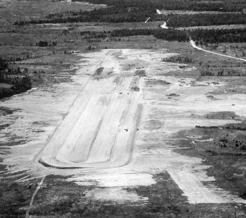
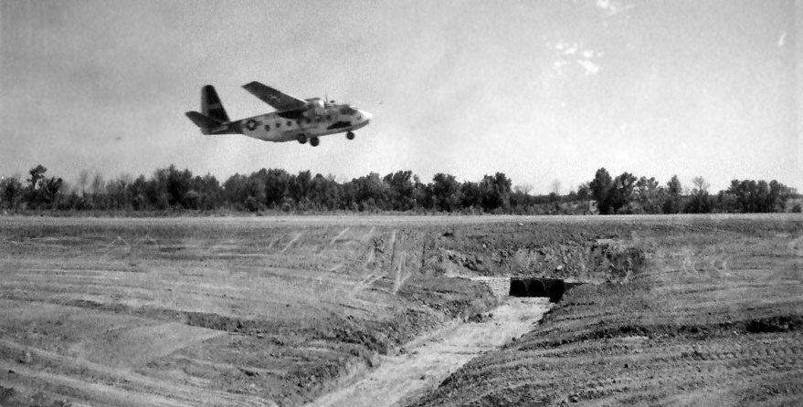
A circa 1954 aerial view looking west at the Sky Drop airfield (from the St. Louis National Personnel Records Center, courtesy of Ron Plante),
showing an east/west unpaved runway with a parallel taxiway.
A circa 1954 photo of the takeoff of a rare Chase C-122 Avitruc from the Sky Drop airfield (from the St. Louis National Personnel Records Center, courtesy of Ron Plante).
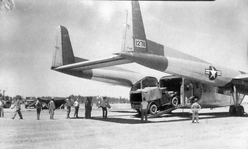
A circa 1954 photo of a truck being unloaded from the rear ramp of a twin-boom Fairchild C-119 Flying Boxcar
on the Sky Drop airfield (from the St. Louis National Personnel Records Center, courtesy of Ron Plante).
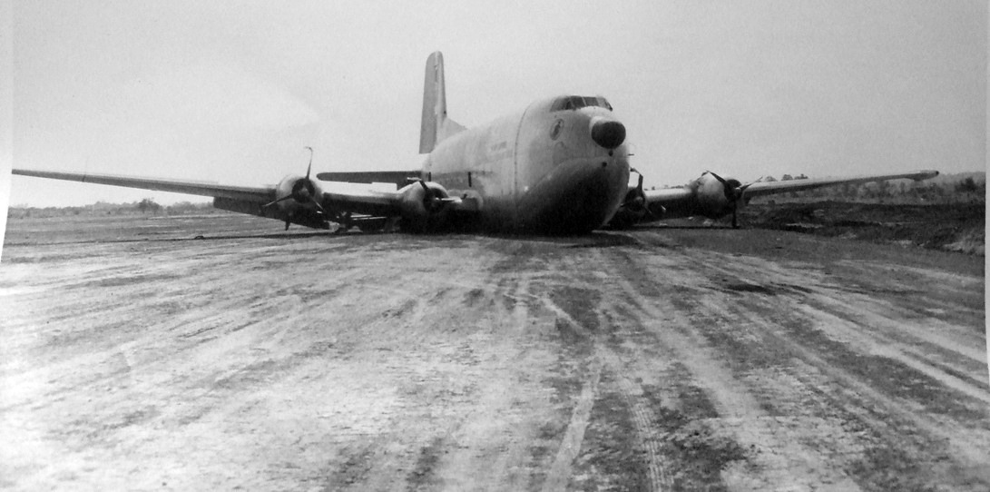
A photo showing the aftermath of the bad landing on 6/27/54 of the 1st Douglas C-124C Globemaster II (51-5210 from Donaldson AFB's 52nd TCS)
at the Sky Drop airfield (from the St. Louis National Personnel Records Center, courtesy of Ron Plante).
Ron Plante reported, “the main gear struck a 12’ dirt fill embankment just short of the approach end.
The main gear detached from the aircraft, and the nose gear was rammed into the cargo compartment. No crew were injured.”
According to Mark Morgan, after the Sky Drop C-124 accident, the “aircraft was classified damaged beyond repair & apparently scrapped on site.”
After the 1954 C-124C accident, Ron Plante reported, “It is unknown if any further flight testing took place at this site.”
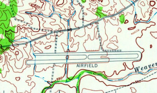
The 1957 USGS topo map depicted the Sky Drop Airfield as an east/west runway, with a parallel taxiway, labeled simply as “Airfield”.
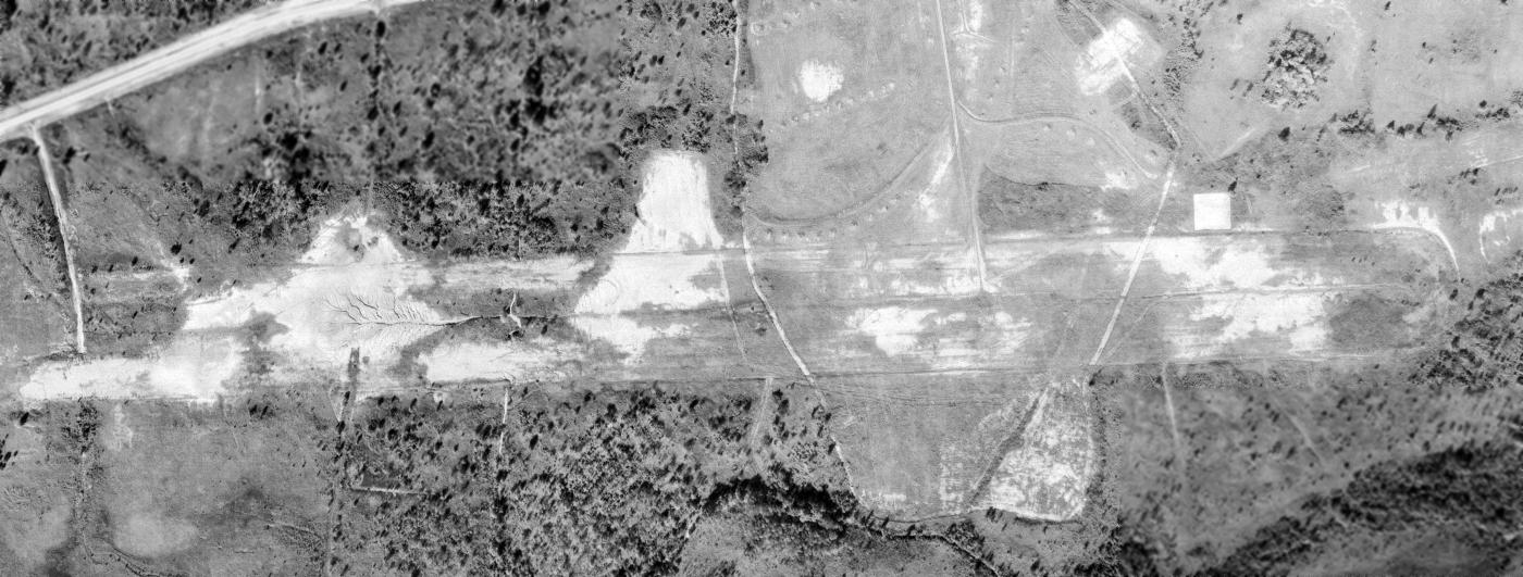
A 10/19/73 USGS aerial photo showed the outline of the Sky Drop Airfield to remain recognizable though deteriorated,
along with a concrete ramp or foundation on the north side of the runway.
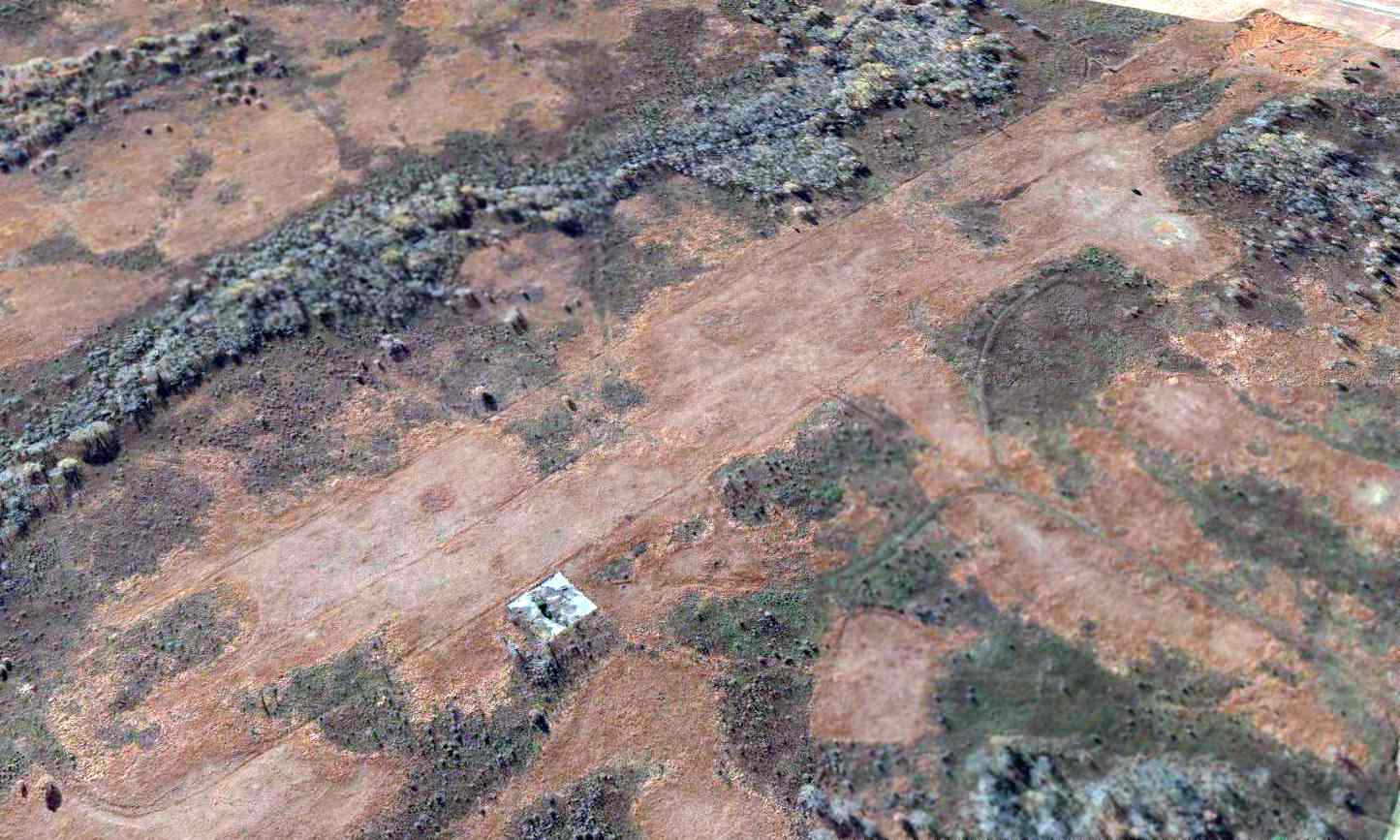
A 2013 aerial view looking southwest still showed the outline of the Sky Drop Airfield to remain recognizable,
along with possibly a concrete foundation on the north side of the runway.
The site of Fort Campbell Sky Drop Army Airfield is located southwest of the intersection of Artillery Road & Angels Road.
Thanks to Ron Plante for pointing out this airfield.
____________________________________________________
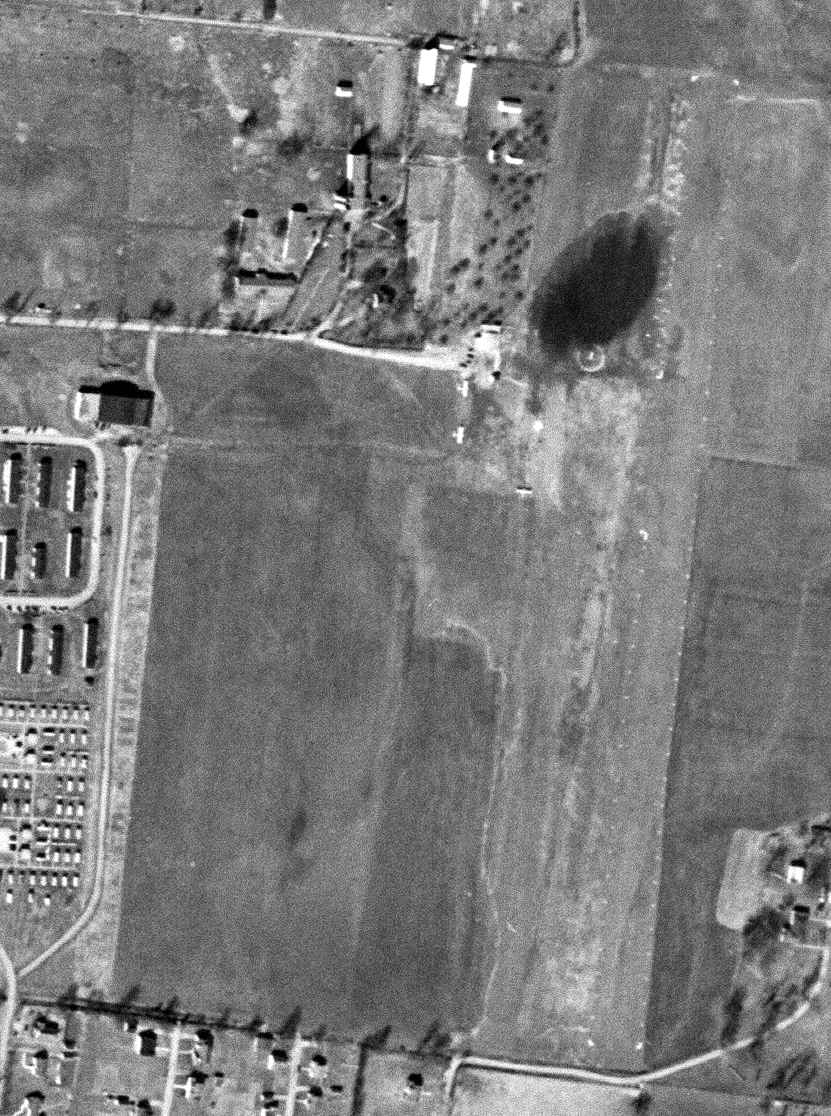
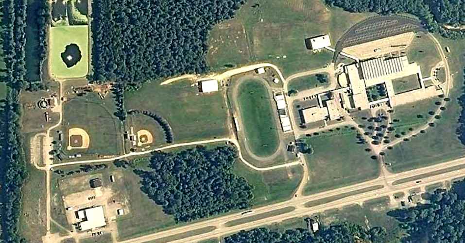
Middle Tennessee State College Airport, Murfreesboro, TN
35.848, -86.368 (Southeast of Nashville, TN)
A 2/23/50 USGS aerial view of the MTSC Airport.
No airfield was yet depicted at this location on the 1941 USGS topo map.
According to the book “The Aviation History of Tennessee” by Jim Fulbright (courtesy of David Stevenson),
“In the Spring of 1943, Middle Tennessee State College was chosen by the Army's Flight Training Command
as the site for the 11th College Training Detachment.
State College Airport was constructed on a few acres of the campus now occupied by Forrest Hall.
A training contract went to a Nashville firm known as the Murfreesboro Flying School & later, Murfreesboro Flying Service.”
According to the book “The Aviation History of Tennessee” by Jim Fulbright (courtesy of David Stevenson),
“In 1946 the college formed an aviation club consisting of students from the training detachment,
as well as those planning an aviation career.
In 1948 the college organized a Civil Air Patrol squadron which was supervised by Major Elmour Merriwether & Captain Miller Lanier.”
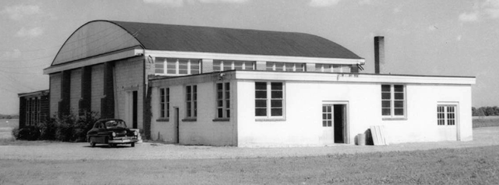
A circa 1950s photo of the MTSC Airport hangar (courtesy of Curtis Parish).
A 1952 photo of 2 Aeronca L-19s during Civil Air Patrol maneuvers at the MTSC Airport.
According to the book “The Aviation History of Tennessee” by Jim Fulbright (courtesy of David Stevenson),
“In 1952 a new airport for Murfreesboro was established.
Both MTSU & public aviation operations moved to the site.”
A map from the 1952 Middle Tennessee State University yearbook labeled the former MTSC Airport hangar as the “ROTC Armory”.
The 1957 USGS topo map no longer depicted the MTSC Airport.
An 8/1/11 aerial photo showed many buildings of Middle Tennessee State University covering the site of the MTSC Airport,
with the former hangar near the top-left.
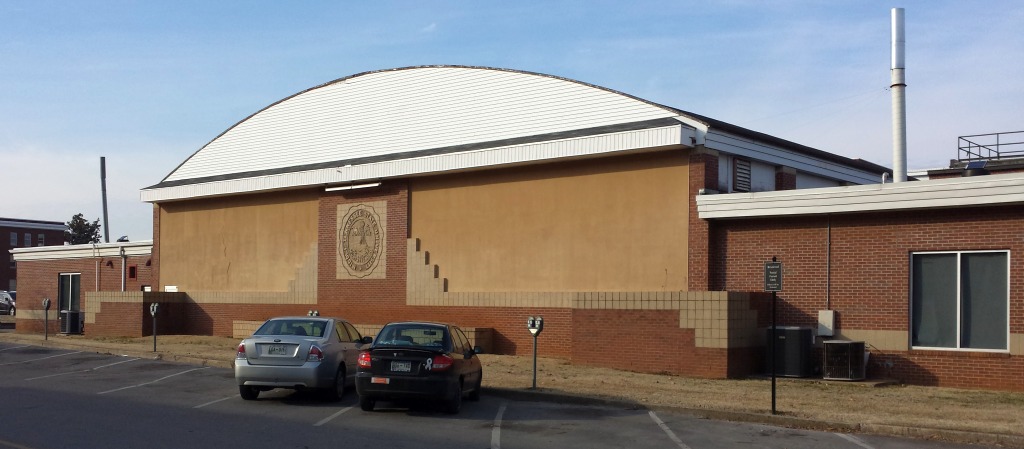
A 2/10/14 photo by Curtis Parish of the former hangar which remains at the site of the MTSC Airport.
Curtis reported, “The ROTC program at MTSU uses it. Part of it is used for an indoor electronic rifle range.”
The site of MTSC Airport is located at the intersection of Champion Way & Military Memorial.
Thanks to Curtis Parish for pointing out this airfield.
____________________________________________________
Sky Harbor Airport, Murfreesboro, TN
35.923, -86.473 (Southeast of Nashville, TN)
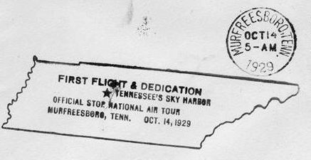
A postmark commemorating the 10/14/29 dedication of Sky Harbor Airport.
According to the book “The Aviation History of Tennessee” by Jim Fulbright (courtesy of David Stevenson),
“Early in 1929 residents of Rutherford County learned that a large airline planned to open an airfield in the area.
On 3/22/29, Interstate Airlines Inc. bought 152 acres of land on what had been the Martha Crostwaite Farm,
seven miles north of Murfreesboro on the Old Dixie Highway.
Construction of the airfield began on June 5,
and the official dedication of Sky Harbor Airport was held 10/14/29.
Jimmy Doolittle, air racer & famous research pilot who literally invented instrument flight,
performed in the dedication ceremonies.”
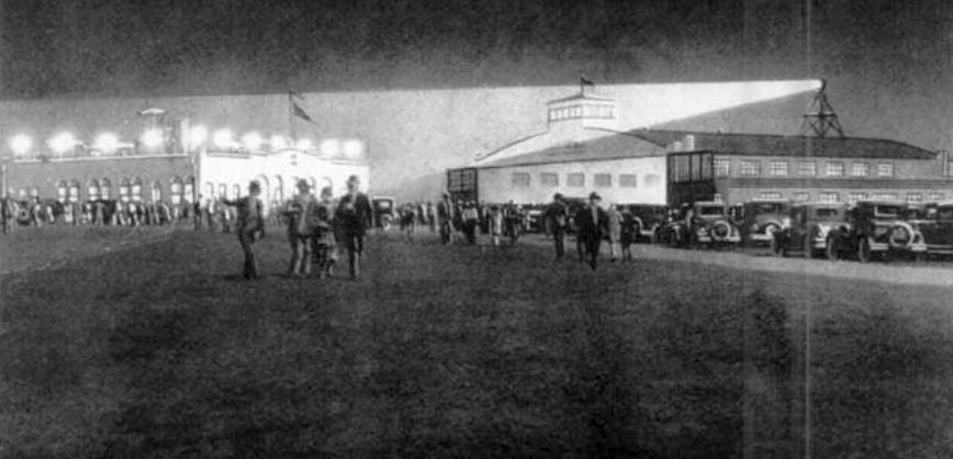
A circa 1929-37 artist's depiction of a nighttime event at Sky Harbor Airport.
A circa 1929 plan of Sky Harbor, from an Interstate Airlines brochure promoting the field (courtesy of Tom Heitzman).
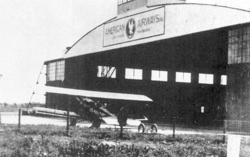
A circa 1930s photo of a U.S. Mail biplane (type unknown) in front of an American Airways hangar st Sky Harbor.
In 1930 the 105th Observation Squadron used Sky Harbor on a temporary basis for a few months,
but its distance from Nashville made it a less desirable National Guard post.
On 11/25/30, the 105th Observation Squadron was disbanded & the aircraft & equipment were moved to Memphis Municipal Airport,
a move made necessary in order to comply with the requirement by the Militia Bureau for National Guard air units to operate from an A-1 airport.
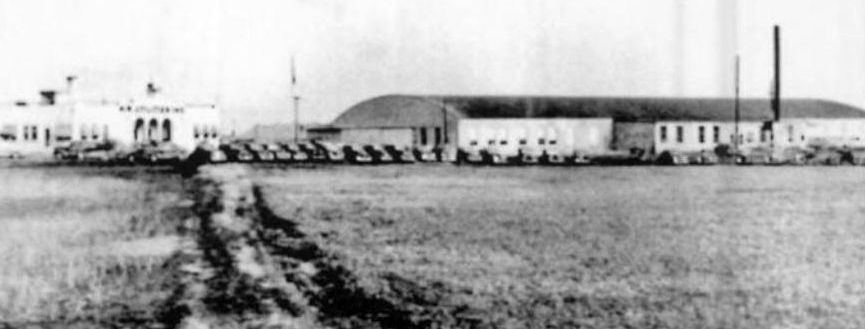
A circa 1930s photo of Sky Harbor's terminal building & main hangar.
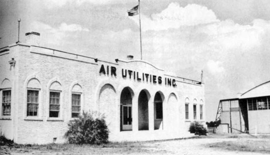
A circa 1930s photo of Sky Harbor's whitewashed terminal building, marked “Air Utilities Inc.”
Weather instruments such as barometers were mounted on the corners of the roof.
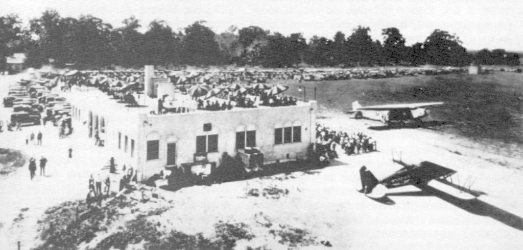
A circa 1930s photo of a large crowd gathered at Sky Harbor, with a Fokker TriMotor & an Airmail biplane (type unidentified) on the field.
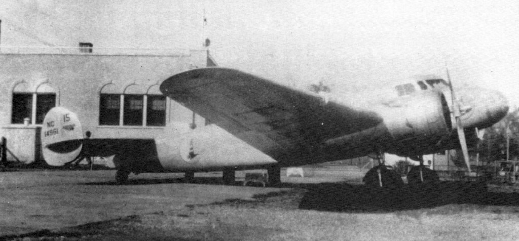
A 1935 photo of an Eastern Air Lines Lockheed 10B at Sky Harbor.
Eastern operated the aircraft on its Chicago to Miami route, and this particular 10B was the 4th example delivered to Eastern.
The 1941 USGS topo map didn't depict Sky Harbor Airport,
just a few small buildings along its southwest side.
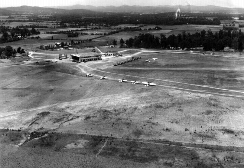
A June 1941 aerial view looking southwest at Sky Harbor hangar, showing the hangar & terminal, and over a dozen military aircraft on the field.
A June 1941 aerial view looking northwest at Sky Harbor hangar, showing the hangar & terminal, and over a dozen military aircraft on the field.
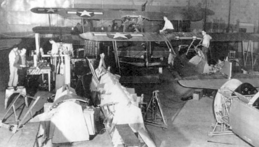
A circa 1940s photo of what appear to be Army Stearman biplanes under maintenance inside a Sky Harbor hangar.
The March 1944 Nashville Sectional Chart (courtesy of Thomas Ramsey) didn't depict Sky Harbor Airport,
According to the book “The Aviation History of Tennessee” by Jim Fulbright (courtesy of David Stevenson),
“During WW2 Sky Harbor was purchased by Air Utilities Inc. for its plane repair plant.
Later it became Alfred Hoffman's bomb factory, where practice bombs were made.”
The only aeronautical chart depiction which has been located of Sky Harbor was on the October 1946 Nashville Sectional.
It depicted Sky Harbor as a commercial/municipal airport.
Sky Harbor evidently closed (for reasons unknown) at some point between 1946-50,
as the 1950 USGS topo map didn't label Sky Harbor Airport, but the terminal building & hangar were still depicted.
The last photo which has been located of Sky Harbor Airport was a 3/22/51 USGS aerial view.
The field had 2 grass runways, the terminal building, and the main hangar's roof was painted with “Sky Harbor Airport, Murfreesboro Tennessee”.
But no aircraft were visible on the field.
The 1972 USGS topo map continued to depict Sky Harbor's terminal building & hangar.
The 1977 USGS topo map continued to depict Sky Harbor's hangar,
but the terminal building had been removed & a new street had been built over it.
According to the 1996 book “The Aviation History of Tennessee” by Jim Fulbright (courtesy of David Stevenson),
“Today the old terminal area is the site of a boat manufacturing plant,
and the airfield has returned to agricultural use.”
A 1997 USGS aerial photo showed a larger industrial building on the site of Sky Harbor's hangar.
It is not known if this building incorporated the original hangar,
or was a newer building built over the hangar site.
The 1999 USGS topo map continued to depict Sky Harbor's hangar.
An 8/1/11 aerial photo showed houses covering the northern portion of the Sky Harbor site.
A large industrial building sat on the site of Sky Harbor's hangar, but it is indeterminate whether this building incorporated the original hangar,
or was a newer building built over the hangar site.
An article in the 7/18/13 issue of The Tennessean (courtesy of Curt Parish) described how a drive-in movie theater was being proposed for the site of Sky Harbor Airport.
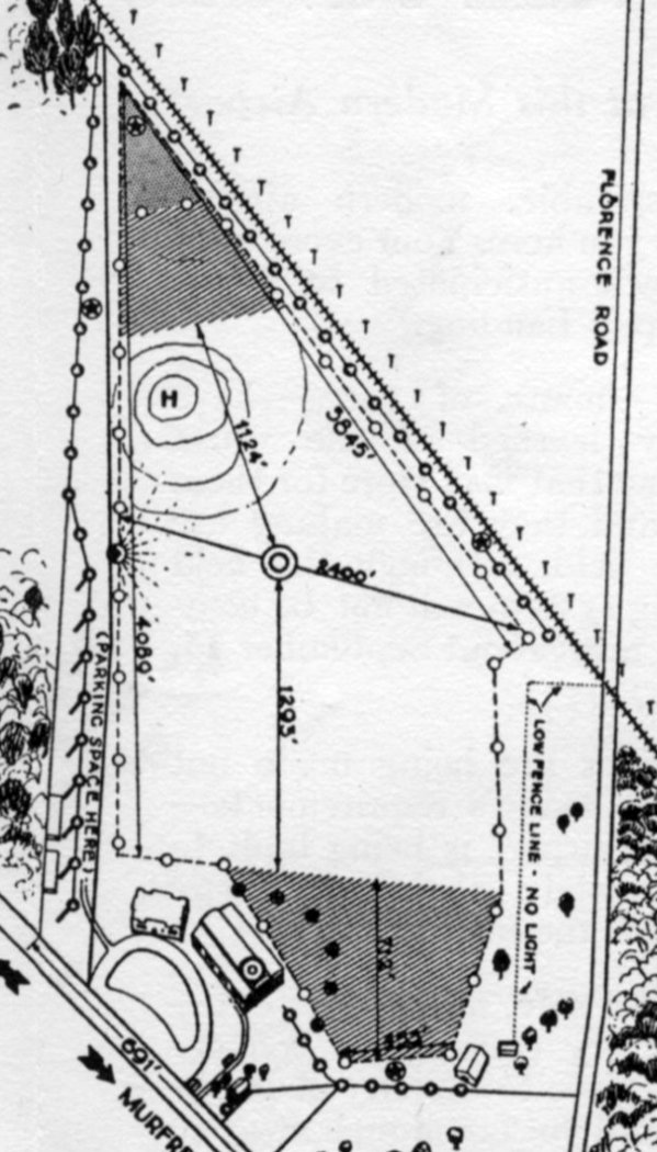
The site of Sky Harbor Airport is located northwest of the intersection of Old Nashville Highway & Florence Road.
____________________________________________________
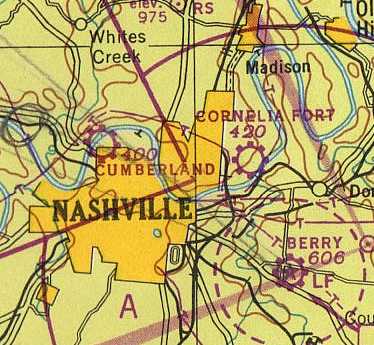
Gillespie Field / Cumberland Airport, Nashville, TN
36.2, -86.813 (Northwest of Downtown Nashville, TN)
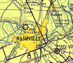
Gillespie Field, as depicted on the March 1944 Nashville Sectional Chart (courtesy of Thomas Ramsey).
According to the book “The Aviation History of Tennessee” by Jim Fulbright (courtesy of David Stevenson),
“Gillespie Field was developed in 1941 by Nashville entrepreneur & pilot Jim Gillespie.
His idea was to give private & commercial aviation a new home
at a time when military activity was taking over virtually all of Berry Field.
Gillespie purchased property north of downtown, along the river, and began a flying school.
The airport consisted of a a northeast/southwest turf runway.
The total usable length was 3,300' which included a 1,500' paved portion on the northeast end
where the hangars & offices were located.”
According to Wikipedia, “During World War II, it was leased to the United States Army Air Forces as a training airfield.”
From 10/3/42-11/2/42 the following Known USAAF units trained at Gillespie Field:
the 305th, 306th, 307th, and 308th Dive Bombardment Squadrons.
The earliest depiction which has been located of Gillespie Field
was on the March 1944 Nashville Sectional Chart (courtesy of Thomas Ramsey).
According to Wikipedia, “Returned after the war to private ownership,
it was later bought by the city of Nashville & was renamed 'Cumberland Field'.”
The October 1946 Nashville Sectional Chart (courtesy of Jim Stanton)
depicted Cumberland Airport as a commercial/municipal airport.
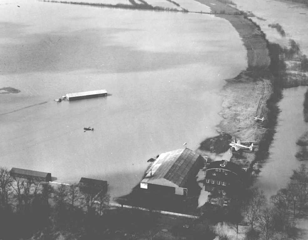
The earliest photo which has been located of Cumberland Airport
was a sad 2/14/48 aerial view looking southwest during a flood.
It showed 2 aircraft remaining above water near the 2 hangars, but 3 smaller aircraft partially submerged on the middle of the field.
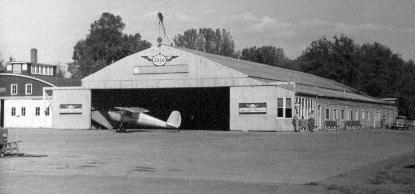
A 1951 photo of a Cessna 120 or 140 in front of a Cumberland Field hangar (courtesy of Brad Baisley).
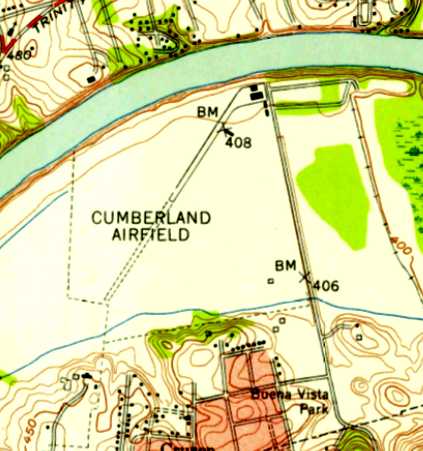
The 1952 USGS topo map depicted “Cumberland Airfield” as having a single northeast/southwest runway, of which the northeastern half was paved.
A paved ramp & 4 small buildings were depicted on the northeast side.
The last photo which has been located of Cumberland Field was a circa 1950s aerial view (courtesy of David Stevenson)
showing a Bonanza & a taildragger in front of 2 hangars.
According to the book “The Aviation History of Tennessee” by Jim Fulbright (courtesy of David Stevenson),
“Cumberland Field continued to operate into the early 1960s.”
The last depiction which has been located of Cumberland Field was on the 1965 Nashville Sectional Chart (courtesy of John Price),
which depicted Cumberland as having a 2,700' unpaved runway.
The book “The Aviation History of Tennessee” by Jim Fulbright (courtesy of David Stevenson)
observed of Cumberland Field, “The valuable land near the downtown area was eventually redeveloped.”
Cumberland Field was no longer depicted on the 1985-86 TN Aeronautical Chart (courtesy of Alex Hauzer).
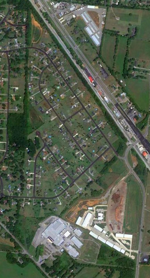
A 1992 USGS aerial photo did not show any remaining trace of the airport.
An 8/1/11 aerial photo did not show any remaining trace of the airport.
The site of Cumberland Airport is located west of the intersection of Great Circle Road & Mainstream Drive.
____________________________________________________
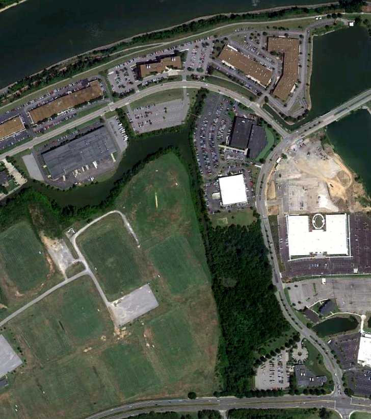
Humpreys County Airport / Waverly Airport, Waverly, TN
36.08, -87.855 (West of Nashville, TN)
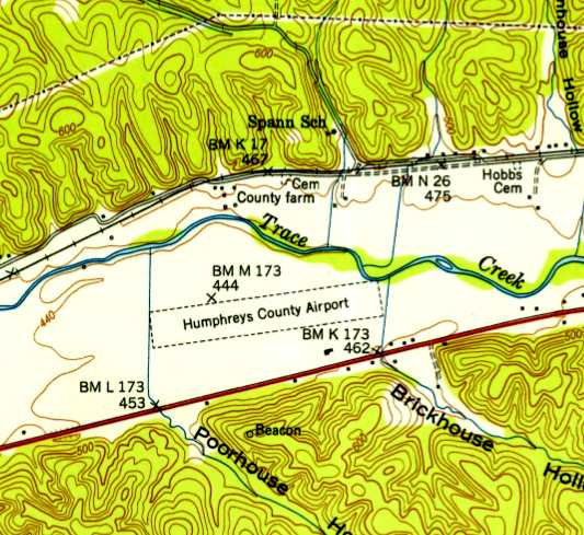
Humphreys County Airport, as depicted on the 1950 USGS topo map.
Photo of the airport has not been located.
Waverly Airport was not yet depicted on the October 1946 Nashville Sectional Chart (courtesy of Jim Stanton).
According to the book “The Aviation History of Tennessee” by Jim Fulbright (courtesy of David Stevenson),
“Waverly's first municipal airport was opened in 1947.
It was located on county property 3 miles west of Waverly on the north side of Highway 70.
It consisted of a 1,600' east/west turf strip which was licensed for public use.”
According to the book “The Aviation History of Tennessee” by Jim Fulbright (courtesy of David Stevenson),
“By 1949 the runway had been extended to 3,100'.
J.L. King managed the airport for the county.”
The earliest depiction which has been located of Humphreys County Airport was on the 1950 USGS topo map.
It depicted the field as having a single unpaved east/west runway with a single small building on the southeast side.
According to the book “The Aviation History of Tennessee” by Jim Fulbright (courtesy of David Stevenson),
“The field was unattended & without facilities until the 1950s.
By then a large metal hangar was constructed & the runway was lighted.
In 1964 the county began building a new high school on the property & the Waverly Airport was closed.”
The 1970 USGS topo map still showed the outline of the western portion of the runway,
but the new high school covered the eastern portion.
A 1999 USGS aerial photo did not show any remaining trace of the airport.
A 4/9/10 aerial photo did not show any remaining trace of the airport.
The site of Waverly Airport is located north of the intersection of Route 70 & Curtis Drive.
____________________________________________________
Cornelia Fort Airport / Cornelia Fort Airpark (M88), Nashville, TN
36.19, -86.703 (Northeast of Downtown Nashville, TN)
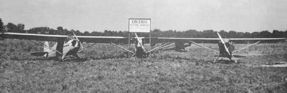
A 1945 photo of 4 taildraggers with a sign for the Colemill Flying Service at Cornelia Fort Airport (courtesy of David Stevenson).
According to the book “The Aviation History of Tennessee” by Jim Fulbright (courtesy of David Stevenson),
“In late 1944 Norman Thomas purchased 200 acres along a bend of the Cumberland River.
Because the property adjoined part of a farm owned by Rufus Fort,
Thomas named the airfield in honor of Fort's daughter, Cornelia.
Fort was one of the the original 5 members of the Women's Auxiliary Ferrying Squadron.
She died in an aircraft accident in 1943,
becoming the first female pilot in U.S. History to be killed on active military duty.”
Logan Colbert reported, “My Grandfather was Ernest Colbert.
He started Colemill in December of 1944 in the north hangar on the Cornelia Fort property.”
However, Cornelia Fort Airpark was not yet listed among active airfields in the 1945 AAF Airfield Directory (courtesy of Scott Murdock).
The earliest depiction which has been located of Cornelia Fort Airport
a 1945 photo of 4 taildraggers with a sign for the Colemill Flying Service at Cornelia Fort Airport (courtesy of David Stevenson).
The earliest depiction which has been located of Cornelia Fort Airport
was on the October 1946 Nashville Sectional Chart (courtesy of Jim Stanton),
which depicted it as a commercial/municipal airport.
According to a 2010 FAA Airport/Facility Directory entry, Cornelia Fort Airpark was established in 11/1946,
but that date is obviously somewhat erroneous.
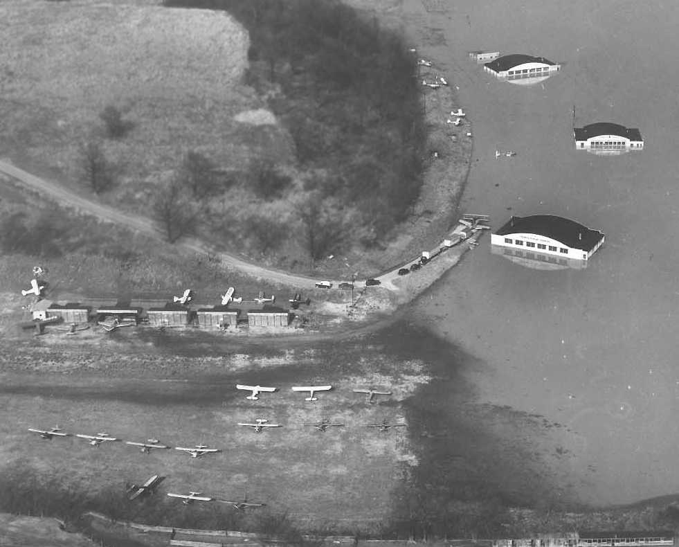
A sad 1950 aerial view looking north at a flooded Cornelia Fort Airport.
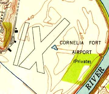
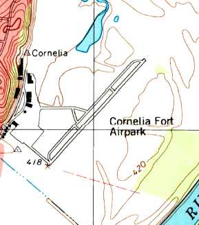
The earliest topo map depiction which has been located of Cornelia Fort Airport was on the 1952 USGS topo map.
It depicted the field as having 2 runways, with a ramp & 4 small buildings on the west side.
According to Wikipedia, “In the early 1950s Ernest Colbert bought out his partner to become sole owner (operating it as Colemill Enterprises).”
Logan Colbert reported, “My Grandfather was Ernest Colbert. He bought [Cornelia Fort] Airport in 1951.”
The 1965 Nashville Sectional Chart (courtesy of John Price) depicted Cornelia Fort as having a 3,000' unpaved runway.
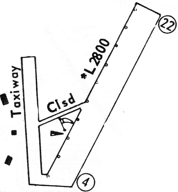
The 1968 Flight Guide (courtesy of Robert Levittan) depicted Cornelia Fort Airport
as having a single 2,800' unpaved Runway 4/22, with a taxiway & 3 small buildings on the west side.
The last aeronautical chart depiction which has been located of Cornelia Fort Airpark
was on the 1985-86 TN Aeronautical Chart (courtesy of Alex Hauzer).
It depicted Cornelia Fort as having a 2,800' paved northeast/southwest runway.
Cornelia Fort Airpark evidently gained a paved runway at some point between 1968-97,
as the 1997 USGS topo map depicted it as having a single paved northeast/southwest runway with a parallel taxiway,
and a ramp & a cluster of buildings along the west side.
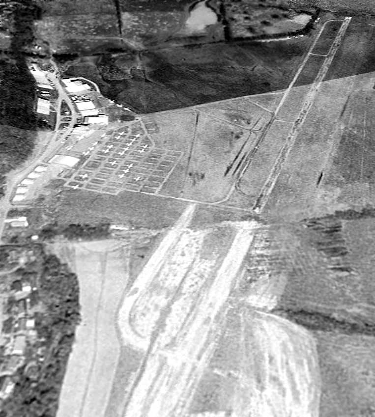
The earliest photo which has been located of Cornelia Fort Airpark was a 3/1/97 aerial view looking northeast,
evidently showing construction in progress to extend Runway 4/22 further to the southwest.
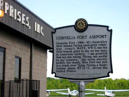
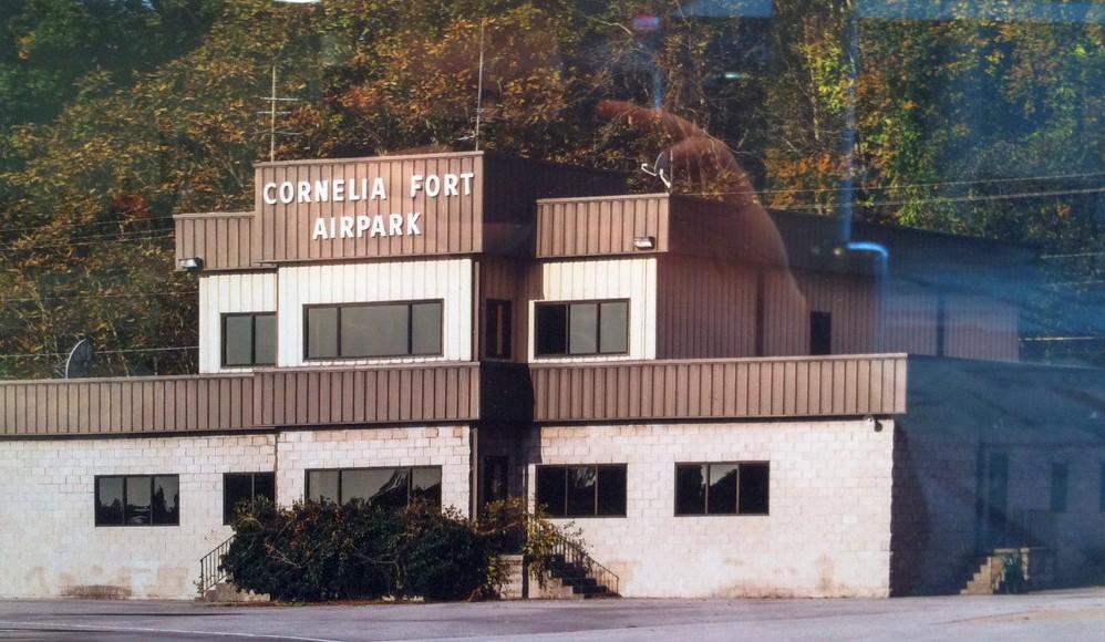
An undated (circa 2000-2011) photo of the historical plaque at Cornelia Fort Airport, in front of the Colemill Enterprises Building.
Ironically, although the plaque is entitled “Cornelia Fort Airport”,
it says absolutely nothing about the airport, instead summarizing the history of the airport's namesake.
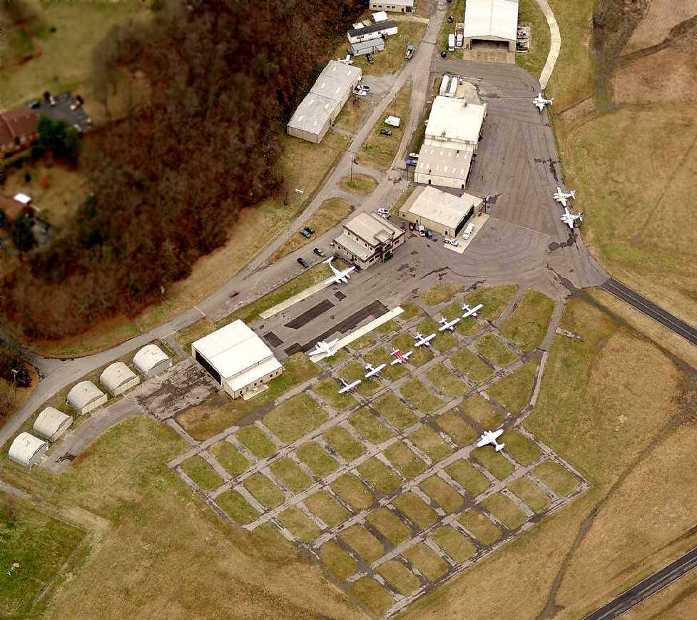
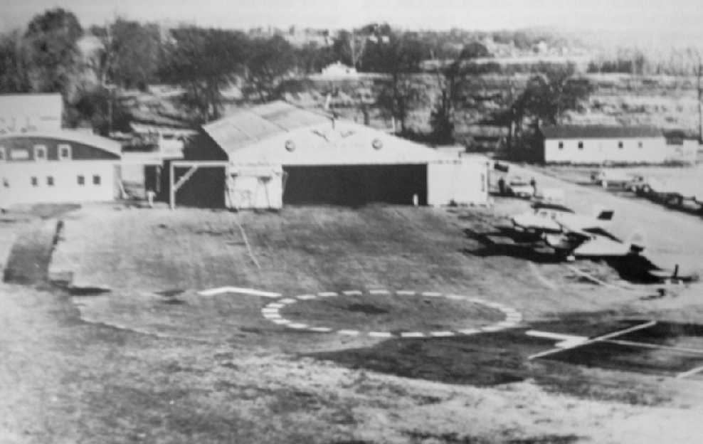
An undated (circa 2007-2011?) aerial view looking north at Cornelia Fort Airpark,
showing a dozen aircraft, but also a large number of empty parking spaces.
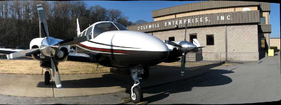
An undated (circa 2007-2011?) photo showing a pretty twin Cessna in front of the Colemill Enterprises building at Cornelia Fort Airpark,
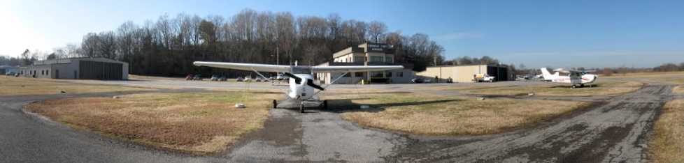
An undated (circa 2007-2011?) panoramic photo looking northwest at 2 Cessna 172 on Cornelia Fort's ramp.
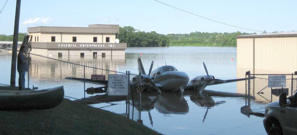
A sad 5/3/10 photo looking north at the result of the 2010 flood, showing a partially submerged Beech Baron in front of the Colemill Enterprises building.
According to Jon Bailey, “The May 2010 flood sealed its fate.”
According to Wikipedia, airport owner Ernest Colbert sought a buyer for Cornelia Fort Airpark
after defaulting on a $1.4 million loan in 2010 (after it was inundated in the 2010 Tennessee floods).
According to a 2010 FAA Airport/Facility Directory entry, Cornelia Fort Airpark covered an area of 300 acres,
had a single 3,500' asphalt Runway 4/22, was owned by Colemill Enterprises, and the Manager was Scott White.
The airport was said to have 27 based aircraft, and to conduct an average of 82 takeoffs or landings per day.
According to Wikipedia, in 2011 the city of Nashville acquired the 141 acre airport to include it as non-aviation part of Shelby Park.
Jon Bailey reported in 2011, “Cornelia Fort has closed.”
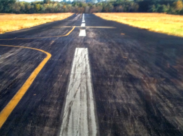
An 8/2/11 aerial photo looking northeast showed closed-runway “X” markings on Cornelia Fort's runway.
The airport otherwise remained completely intact.
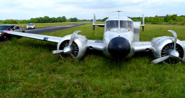
An April 2012 photo of a Beech 18 which landed gear-up at Cornelia Fort more than a year after the airport closed.
According a 4/22/12 Nashville Police Department press release, “Metro Police & the Federal Aviation Administration
are working to identify the person or persons who crash landed a 1961 Beechcraft twin-engine airplane on grass at the closed Cornelia Fort Airpark in East Nashville.
The airpark has been out of operation for a number of months & is presently under the control of the Metro Parks Department.
Large yellow Xs are painted on the runway as a sign to aircraft that the facility is closed.
A Parks Department maintenance worker noticed the airplane in the grass to the left of the runway Saturday morning.
When it was still there today, the worker notified Parks Police officers.
The landing gear mechanism on the airplane apparently became inoperable.
It is believed the pilot(s) cut the engines before belly-landing the plane in a large grassy area adjacent to the runway.
Markings in the grass show that the plane traveled about 2/10th of a mile before coming to a stop. The propellers & engines show obvious damage.
The plane is registered to Great American Transportation, Inc., which lists its address as Cornelia Fort Airpark.
The plane is believed to have been housed at the airpark in the past.
At this point, it is unknown who or what was onboard the airplane. There is no indication that anyone was seriously injured.
No cargo or contraband was located when officers arrived today.
The airplane was not in contact with the Nashville control tower, nor was a flight plan filed.
It likely arrived in the dark late Friday or early Saturday.
Officers & the FAA will also be working to learn the plane’s whereabouts over the past several weeks.”
A 2014 photo by Jonathan Westerling of an undated photo of Cornelia Fort Airpark's terminal building, part of a Metrpolitan Nashville Airport display by Jeff Cashdollar about the history of Cornelia Fort Airpark.
A 2014 photo by Jonathan Westerling of an undated photo of Cornelia Fort Airpark's runway, part of a Metrpolitan Nashville Airport display by Jeff Cashdollar about the history of Cornelia Fort Airpark.
Cornelia Fort Airpark is located east of the intersection of Shadow Lane & Airpark Drive, appropriately enough.
____________________________________________________
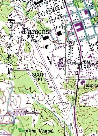
Parsons Municipal Airport / Scott Field, Parsons, TN
35.64, -88.13 (Southwest of Nashville, TN)
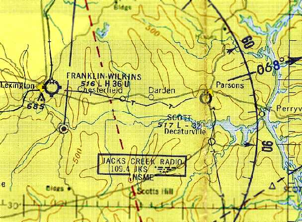
Scott Field, as depicted on the January 1961 Chattanooga Sectional Chart (courtesy of Chris Kennedy).
This general aviation airport was not yet depicted on the August 1956 Sectional Chart (according to Chris Kennedy).
According to the book “The Aviation History of Tennessee” by Jim Fulbright (courtesy of David Stevenson),
“Parsons Municipal Airport was established in December 1959.
The limited facilities originally consisted of a 2,900' chert runway.”
The earliest depiction which has been located of Scott Field
was on the January 1961 Chattanooga Sectional Chart (courtesy of Chris Kennedy).
It depicted the field as having a 3,200' unpaved runway.
Scott Field evidently gained a paved runway at some point between 1961-86,
as the 1986 USGS topo map depicted Scott Field as having a single paved northwest/southeast runway,
with a few small buildings along the east side.
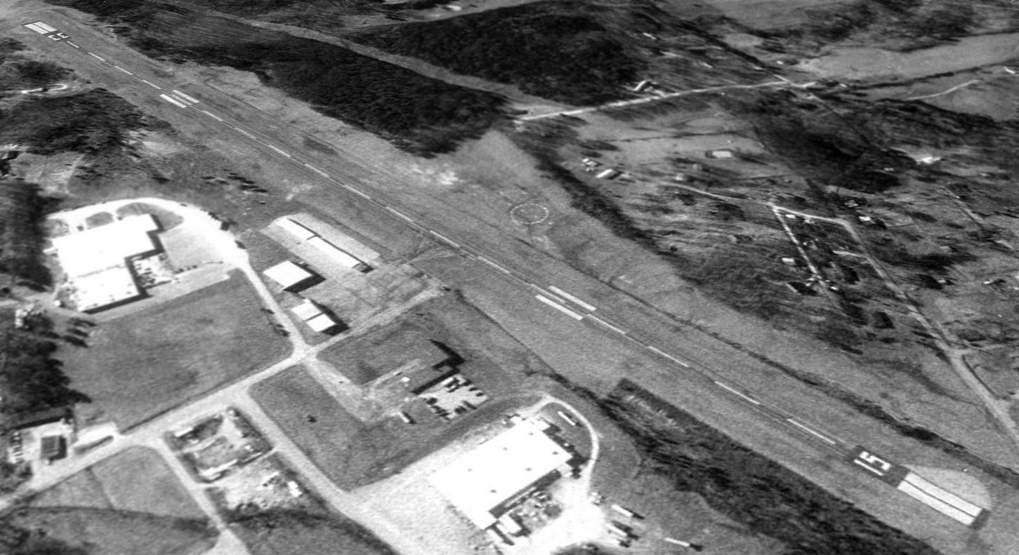
The earliest photo which has been located of Scott Field was a 1997 USGS aerial view looking southwest.
It depicted the field as having a single paved Runway 15/33, with a taxiway leading to a small ramp on the east side with a few small hangars.
No aircraft were visible in the photo.
The last aeronautical chart depiction which has been located of Scott Field
was on the April 2004 Memphis Sectional Chart (courtesy of Chris Kennedy).
It depicted the field as having a single paved 4,000' runway.
A larger Beech River Regional Airport opened in 2006 a few miles to the northwest.
Scott Field was closed on 7/1/06, according to Damon Morris.
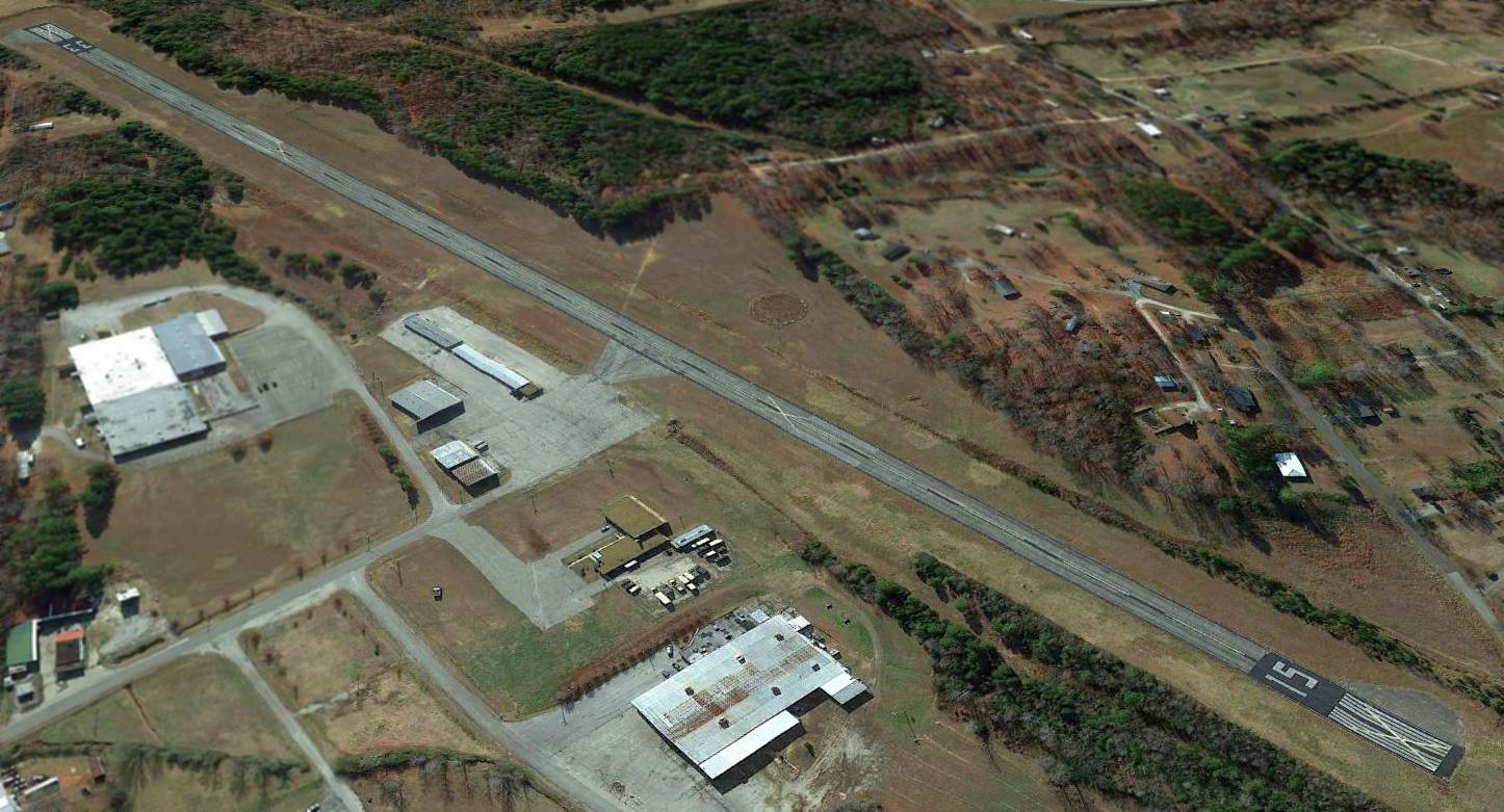
The last photo which has been located showing Scott Field remaining intact was a 2012 aerial view looking southwest.
Although the runway was painted with closed-runway “X” symbols, the airport otherwise remained intact.
Stephen Brookfield observed that a 2015 aerial photo shows baseball diamonds had been constructed over the southern portion of Scott Field's runway at some point between 2012-2015.
The site of Scott Field is located west of the intersection of West Holly Street & West 9th Street.
Thanks to Chris Kennedy for pointing out this airfield.
____________________________________________________
Smithville Intermediate Field, Smithville, TN
35.96, -85.79 (Southeast of Nashville, TN)
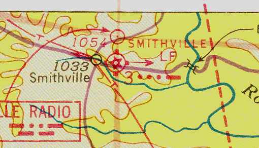
Smithville Intermediate Field, as depicted on the April 1941 Chattanooga Sectional Chart (courtesy of Chris Kennedy).
The Smithville Intermediate Field was one of the Department of Commerce's network of fields
which were established in the 1930s for the emergency use of commercial aircraft flying airways between major cities.
Smithville was not yet listed among active airfields in the 1934 Department of Commerce Airfield Directory (according to Chris Kennedy).
According to the book “The Aviation History of Tennessee” by Jim Fulbright (courtesy of David Stevenson),
“The first airport at Smithville was established in the mid-1930s
as a U.S. Department of Commerce emergency airfield on the Nashville-to-Washington airway.”
The earliest reference which has been located to the Smithville Intermediate Field
was in The Airport Directory Company's 1938 Airport Directory (courtesy of Chris Kennedy).
It described Smithville as the Department of Commerce's Site 3 along the Nashville-Washington Airway.
The field was said to consists of 2 runways in a cross shape,
measuring 3,420' east/west & 2,400' north/south.
The earliest depiction which has been located of the Smithville Intermediate Field
was on the April 1941 Chattanooga Sectional Chart (courtesy of Chris Kennedy).
It depicted Smithville as Site 3.
The only photo which has been located showing the Smithville Intermediate Field while it was operational
was a 10/29/43 aerial view looking north from the 1945 AAF Airfield Directory (courtesy of Scott Murdock).
It depicted Smithville as having 2 grass runways.
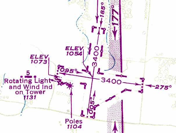
The 1945 AAF Airfield Directory (courtesy of Scott Murdock) described Smithville Intermediate Field
as a 79 acre irregularly-shaped property having 2 sod runways, measuring 3,420' east/west & 3,400' north/south.
The field was not said to have any hangars, to be owned by private interests,
and operated by the Civil Aeronautics Administration.
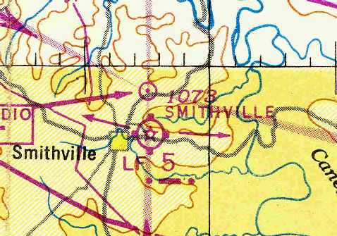
The designation of the Smithville Intermediate Field had evidently been changed at some point between 1941-46,
as the October 1946 Chattanooga Sectional Chart (courtesy of Chris Kennedy) labeled Smithville as Site 5.
The last depiction which has been located of Smithville Intermediate Field as an active airfield
was on the 1949 USAF Pilot's Handbook (courtesy of Chris Kennedy).
It depicted the field as having two 3,400' unpaved runways.
The Smithville airfield was evidently closed at some point between 1949-54,
as it was no longer depicted at all on the August 1954 Chattanooga Sectional Chart (courtesy of Chris Kennedy).
It had lasted somewhat longer than many other Intermediate Fields,
many of which were no longer needed due to advances in the range & reliability of commercial aircraft.
The 1984 USGS topo map still depicted the outline of the Smithville airfield,
although it was no longer labeled as such.
The map also labeled the road bordering the west side of the property as “Airport Road”
(although later street maps show that it was evidently renamed “Smith Road” at some point between 1984-2005).
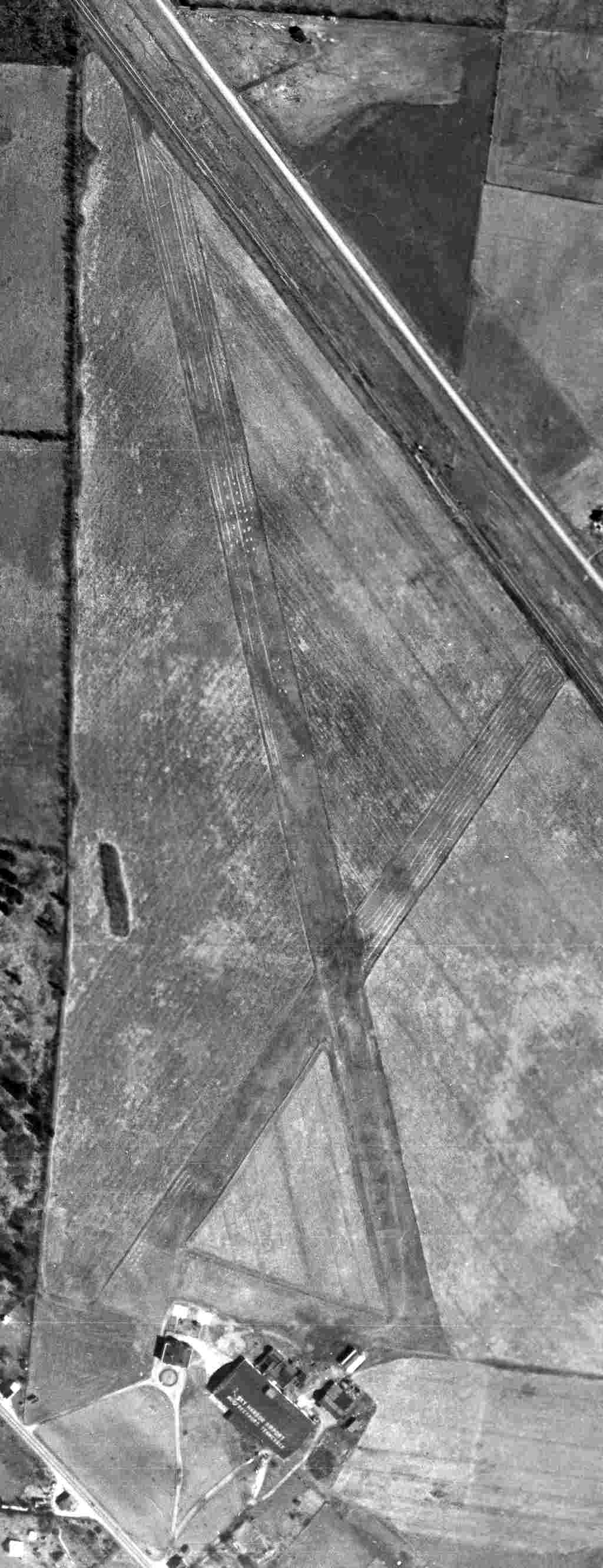
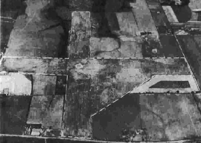
A 2014 aerial photo showed that the outlines of the former Smithville Intermediate Field runways were still quite recognizable.
There do not appear to be any buildings at the site related to its time as an airfield.
The site of Smithville Intermediate Field is located northeast of the intersection of Smith Road & Steeplechase Drive.
____________________________________________________
Blackwood Field, Old Hickory, TN
36.22, -86.607 (Northeast of Nashville, TN)
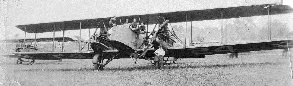
An undated photo of Army biplanes (type undetermined)
at Blackwood Field (courtesy of the TN State Library, via Marvin Maes).
This former military airfield is located on the property of The Hermitage
(the home of President Andrew Jackson).
Blackwood Field was opened in 1921 to house the First Squadron, Air Service, Tennessee National Guard.
The airfield property consisted of 100 acres, on which 2 hangars were erected.
The historical marker at the site (pictured above) indicates
that H.O. Blackwood gave $1,000 to aid the construction of the field.
However, a history of the squadron indicates that H.O. Blackwood donated a farm adjacent to The Hermitage,
and that a WW1-era hangar was moved from Memphis to the site.
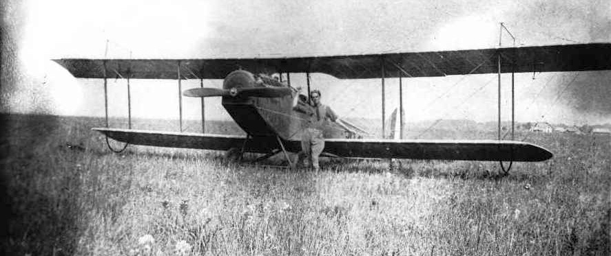
A circa 1920-25 photo of an unidentified pilot in front of an Army JN-4 Jenny biplane at Blackwood Field.
The flying unit at Blackwood Field was redesignated the 136th Air Observation Squadron at the end of 1921,
and operated four new Curtiss JN-6HG Jennys & one DeHavilland DH-4B aircraft.
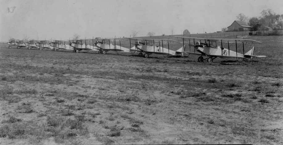
A circa 1922-28 photo of 9 Army JN-4 Jenny biplanes at Blackwood Field.
Blackwood's squadron was further redesignated the 105th Observation Squadron in 1923.
The first airmail flight from Nashville was conducted from Blackwood Field to Chicago in 1924.
A photo of J.W.Ray sitting on a Martin B-2 bomber at Blackwood Field in 1924.
Blackwood's 105th Observation Squadron received 0-2 observation airplanes in 1926.
According to Peggie Black, "My grandfather, Frank McCampbell was a member of the 105th AS based out of Blackwood Field."
According to an article in the 12/21/03 issue of The Tennessean (courtesy of Marvin Maes),
the poor condition of the unpaved roads leading to Blackwood Field (and the cost of improving them)
removed Blackwood from contention for serving as a permanent airmail airfield for Nashville.
The increasing use of airmail also brought about the need for a closer airport to Nashville,
eventually leading to the establishment of McConnell Field (west of downtown Nashville) in 1927.
The 105th Observation Squadron relocated to McConnell Field in 1927.
According to the book “The Aviation History of Tennessee” by Jim Fulbright (courtesy of David Stevenson),
“Although local pilots continued to use Blackwood Field for a time, it was closed in 1928.”
Nothing was depicted at the site of the airfield on the 1932 USGS topo map.
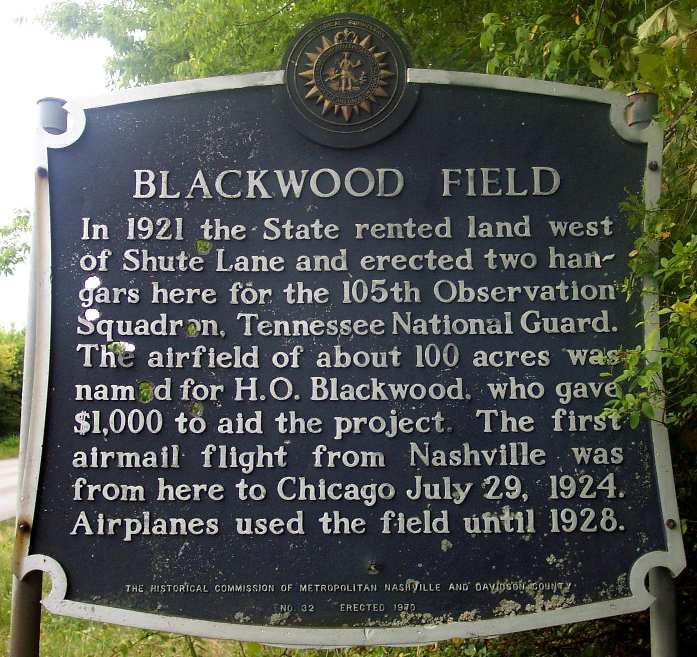
A 8/02 photo by Paul Freeman of a historical marker which was erected in 1970 along the west side of Shute Lane,
the eastern boundary of the site of Blackwood Field.
Remains of concrete footings are visible from adjacent Shute Lane when vegetation doesn’t block the view.
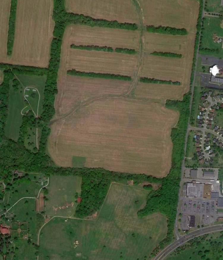
A 2014 aerial view of the general location of Blackwood Field.
Shute Lane runs north/south along the east side of the picture.
The airport site is located northwest of the intersection of Shute Lane & Lebanon Pike.
Thanks to Marvin Maes for pointing out this field.
See also: http://198.65.138.161/military/agency/usaf/118aw.htm
____________________________________________________
UL>
Since this site was first put on the web in 1999, its popularity has grown tremendously.
That has caused it to often exceed bandwidth limitations
set by the company which I pay to host it on the web.
If the total quantity of material on this site is to continue to grow,
it will require ever-increasing funding to pay its expenses.
Therefore, I request financial contributions from site visitors,
to help defray the increasing costs of the site
and ensure that it continues to be available & to grow.
What would you pay for a good aviation magazine, or a good aviation book?
Please consider a donation of an equivalent amount, at the least.
This site is not supported by commercial advertising –
it is purely supported by donations.
If you enjoy the site, and would like to make a financial contribution,
you
may use a credit card via
![]() ,
using one of 2 methods:
,
using one of 2 methods:
To make a one-time donation of an amount of your choice:
Or you can sign up for a $10 monthly subscription to help support the site on an ongoing basis:
Or if you prefer to contact me directly concerning a contribution (for a mailing address to send a check),
please contact me at: paulandterryfreeman@gmail.com
If you enjoy this web site, please support it with a financial contribution.
please contact me at: paulandterryfreeman@gmail.com
If you enjoy this web site, please support it with a financial contribution.
____________________________________________________
This site covers airfields in all 50 states.