Abandoned & Little-Known Airfields:
South-Central Pennsylvania
© 2002, © 2016 by Paul Freeman. Revised 8/29/16.
This site covers airfields in all 50 states: Click here for the site's main menu.
____________________________________________________
Please consider a financial contribution to support the continued growth & operation of this site.
Bedford Airport (1st location) (revised 1/16/16) - Bedford Airport (2nd location) (revised 8/29/16) - Bedford Airport (3rd location) (revised 8/29/16)
Burnt Cabins Landing Strip (revised 5/17/15) - Chambersburg Airport / Sunset Airport (revised 1/21/15) - Devener Airport (revised 1/21/15)
Gettysburg Airport (original location) (added 5/4/16) - Gettysburg Airport (2nd location) (added 5/6/16) - Gratz Airfield / Bressler Airfield / Flying Eagles Airfield (revised 5/11/14)
Indian Lake Airport (revised 5/26/15) - Johnstown Airport (original location) (added 5/19/16) - Skyport Airport (revised 11/16/14) – Worley Field / Waynesboro Airport (revised 11/16/14)
____________________________________________________
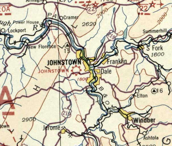
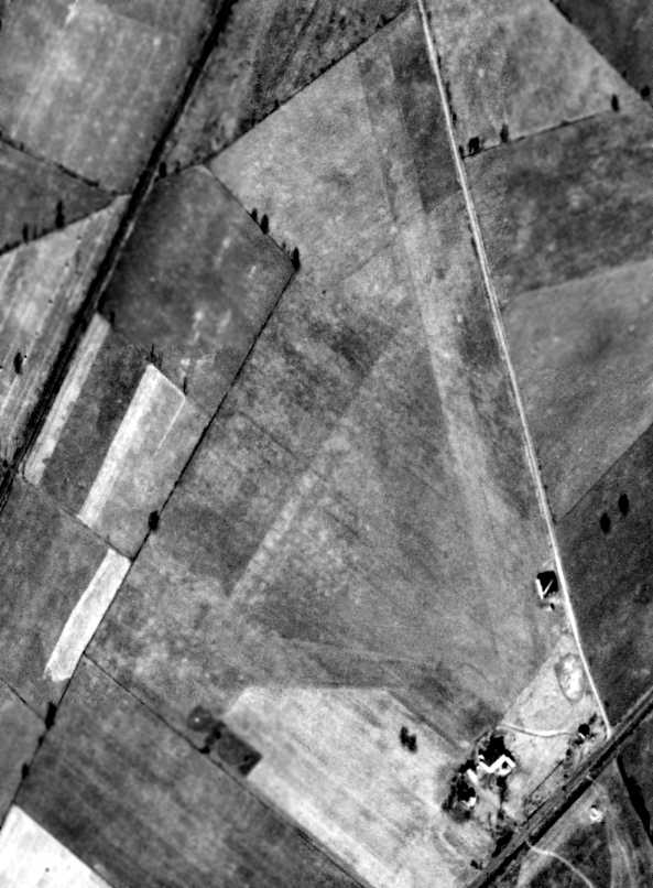
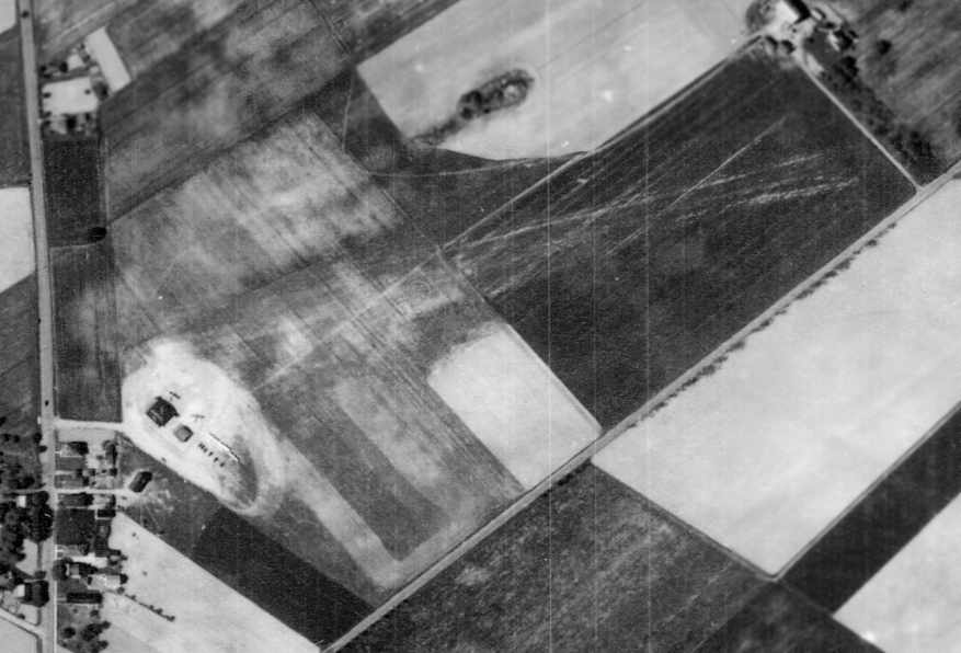
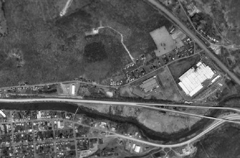
Johnstown Airport (original location), Johnstown, PA
40.32, -78.954 (East of Pittsburgh, PA)
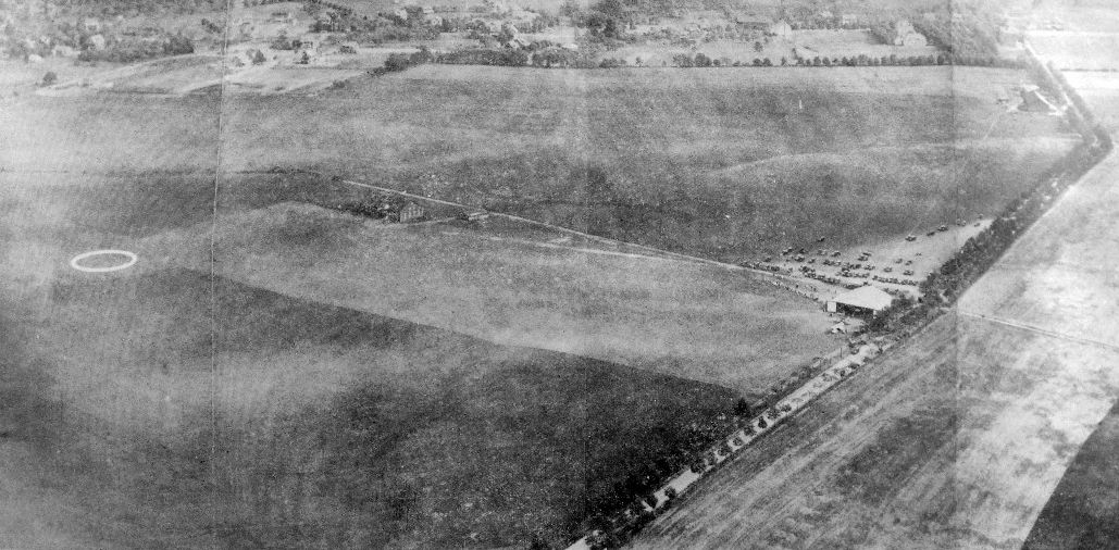
An aerial view looking south at the 7/17/29 dedication of the original Johnstown Airport (from the Philadelphia National Archives, courtesy of Ron Plante).
The original location of Johnstown Airport was on the west side of town.
The earliest depiction which has been located of Johnstown Airport was an aerial view
of the airport's 7/17/29 dedication (from the Philadelphia National Archives, courtesy of Ron Plante).
It depicted Johnstown as having a grass landing area with an airport circle marking,
and a single hangar on the west side.
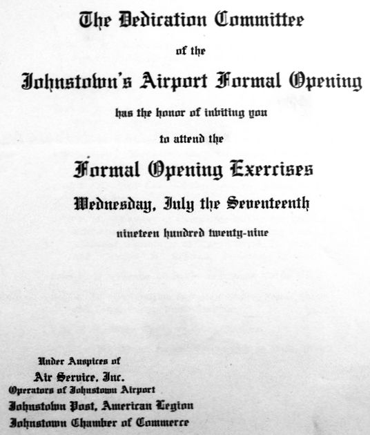
The invitation to the 7/17/29 “Formal Opening Exercises” of the original Johnstown Airport (from the Philadelphia National Archives, courtesy of Ron Plante).
The earliest aeronautical chart depiction which has been located of the original Johnstown Airport
was on the December 1932 Cleveland Sectional Chart.
It depicted Johnstown as a commercial/municipal airport.
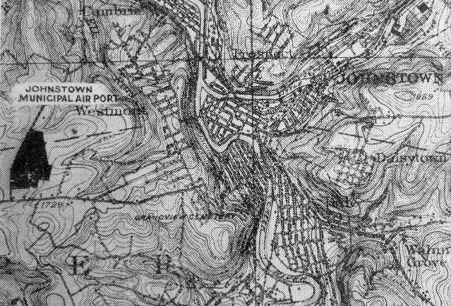
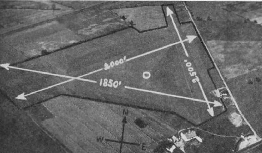
An undated (circa 1930s?) map (from the Philadelphia National Archives, courtesy of Ron Plante)
depicted “Johnstown Municipal Air Port” as an irregularly-shaped property outline .
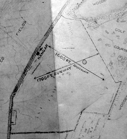
An undated (circa 1930s?) map (from the Philadelphia National Archives, courtesy of Ron Plante)
depicted Johnstown Airport as having 2 unpaved runways, measuring 1,700' northeast/southwest & 1,600' northwest/southeast.
A single hangar was depicted on the west side.
The last aeronautical chart depiction which has been located of the original Johnstown Airport
was on the February 1935 Cleveland Sectional Chart.
It depicted Johnstown as a commercial/municipal airport.
The original Johnstown Airport was evidently closed at some point between 1935-40,
as it was no longer depicted on the March 1940 Cleveland Sectional Chart.
It was eventually replaced by the larger paved-runway Johnstown Airport on the east side of the town.
A 1962 aerial photo showed the site of the original Johnstown Airport had been covered with houses.
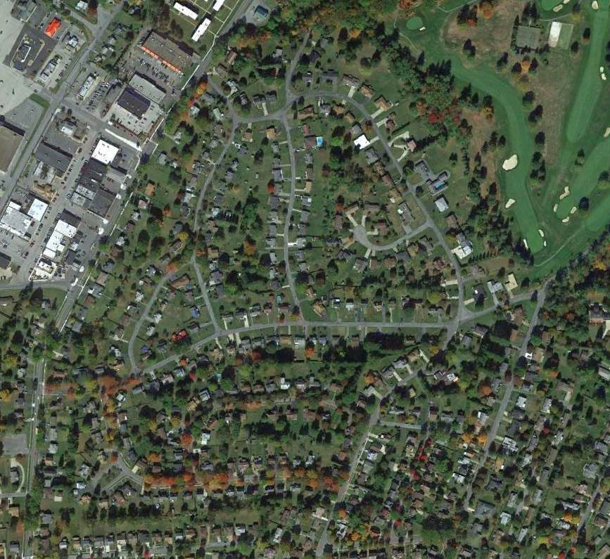
A 2015 aerial view showed houses covering the site of the original Johnstown Airport.
The site of the original Johnstown Airport is located northeast of the intersection of Goucher Road & Emmett Street.
Thanks to Ron Plante for pointing out this airfield.
____________________________________________________
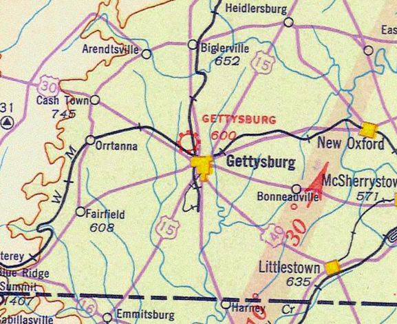
Gettysburg Airport (original location), Gettysburg, PA
39.844, -77.247 (Southwest of Harrisburg, PA)
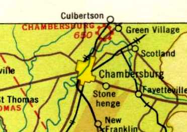
The original Gettysburg Airport, as depicted on the 1935 Washington Sectional Chart.
The original location of Gettysburg Airport was immediately adjacent to the northwest side of town.
According to Wikipedia, “The Gettysburg Flying Service operated airplane tours of the battlefield from the west slope of Oak Ridge in the 1920s
(the Battlefield Airways at the Battlefield Airport across from The Peach Orchard).”
The earliest depiction which has been located of Gettysburg Airport was on the 1935 Washington Sectional Chart,
which depicted Gettysburg as a commercial/municipal airport.
According to Wikipedia, “The field was a 1939 site on the initial transcontinental airmail line.”
According to Geoff Sheen, “In 1942 the airport was moved another 3 miles out of town.”
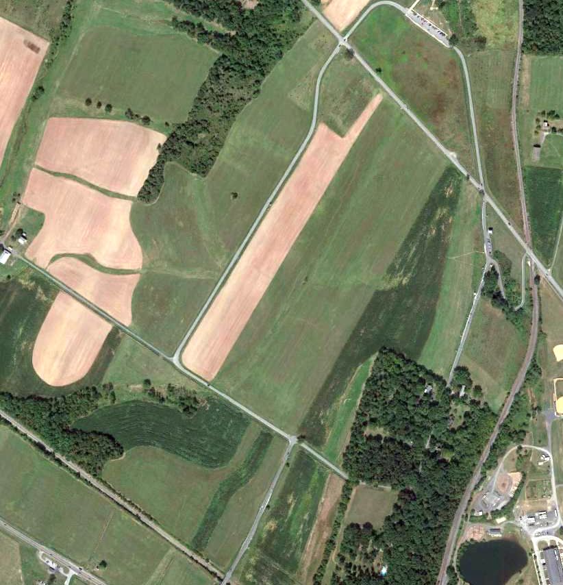
A 2013 aerial view of the site of the original Gettysburg Airport
shows that the site remains clear, and it is possible that the brown plowed northeast/southwest feature is the former runway.
The site of the original Gettysburg Airport is located south of the intersection of Mummasburg Road & Buford Avenue.
Thanks to Geoff Sheen for pointing out this airfield.
____________________________________________________
Gettysburg Airport (2nd location), Gettysburg, PA
39.857, -77.263 (Southwest of Harrisburg, PA)
The 2nd location of Gettysburg Airport, as depicted on the 1947 Washington Sectional Chart.
According to Geoff Sheen, “In 1942 the [original Gettysburg] Airport was moved another 3 miles out of town.”
According to Wikipedia, “TBD Bircher's World War II flight training school was forced to move from Philadelphia because of wartime restrictions on flying.
Bircher bought the W. A. Kelly farm near Gettysburg for the Gettysburg Flying Service
and in 1942 the new airport was built along the Mummasburg Road (2 runways of 1/2 mile & 1,900') after being granted a Civilian Aeronautics Administration license.
Lighting was added to the 1895 Oak Ridge Observation Tower,
and the airport's World War II Civilian Pilot Training program included Temple University students from the battlefield's Lee-Meade Inn.”
According to the Gettysburg Times, Al Stromeyer was caretaker of Gettysburg Airport from 1944 until the closing in 1971.
According to Wikipedia, “In January 1944, Bircher was the owner-operator of the Gettysburg School of Aeronautics
and was notified to close the school circa July 1 (1944 appropriations were for a different airport).
In 1947, farm chicks survived an airplane crash at the airport but died in a subsequent hangar fire.”
The earliest depiction which has been located of the 2nd location of Gettysburg Airport was on the 1947 Washington Sectional Chart,
which depicted Gettysburg as a commercial/municipal airport.
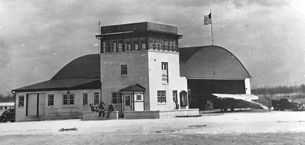
The earliest photo which has been located of the 2nd location of Gettysburg Airport was a circa 1940s photo (courtesy of Ellie Sheen, via Geoff Sheen)
of an arch-roof hangar with an adjacent office & fairly substantial observation tower.
A Piper Cub was in front of the hangar.
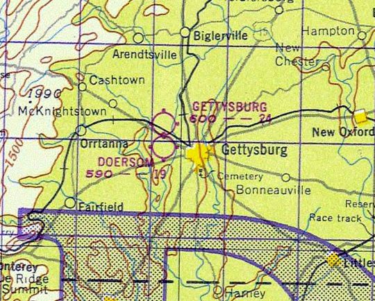
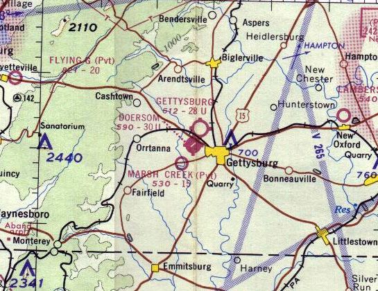
The 2nd location of Gettysburg Airport, as depicted on the 1948 USGS topo map,
along with the nearby Doersom Airport across Route 30 to the south.
According to Wikipedia, “In the 1950s, President Eisenhower used the airport to travel between The White House & and his Gettysburg farm.”
According to Geoff Sheen, “I have an old pot-bellied stove that dad got from the airport when the property was sold.
The story is that Eisenhower used to warm himself in front of this stove when he arrived from Washington to go to his farm.”
An 11/6/55 USGS aerial view depicted the 2nd location of Gettysburg Airport as having 2 perpendicular grass runways.
A closeup from the 11/6/55 USGS aerial view, depicting the arch-roof hangar & one light single-engine aircraft on the northeast side of the 2nd location of Gettysburg Airport.
The 2nd location of Gettysburg Airport, as depicted on the 1961 USGS topo map,
along with the nearby Doersom Airport across Route 30 to the south.
The last aeronautical chart depiction which has been located of the 2nd location of Gettysburg Airport was on the 1964 Washington Sectional Chart.
It depicted Gettysburg Airport as having a 2,800' unpaved runway.
Geoff Sheen recalled, “I grew up in Gettysburg & learned to fly at an old grass strip - the Gettysburg Airport.
My father & 13 other investors bought the airport & ran it for a number of years.
My father was Dr James Sheen - a dentist in Gettysburg, and was VERY involved with flying his whole life.
The building in front of the hangar & the tower must have been destroyed, because by the late 1960s there was just a concrete pad (it was used as a plane wash at the time).
A new small Fixed Base Operation building was built around 1969.”
According to Wikipedia, “In 1969 to compete against the Doersom Airport on the Lincoln Highway,
the Mummasburg Road facility became the 'Gettysburg Airport' of Sheen, Louser, & Roth.”
Geoff Sheen recalled, “It closed as an airport in 1971 & the property was sold in 1981 to a turf farmer.”
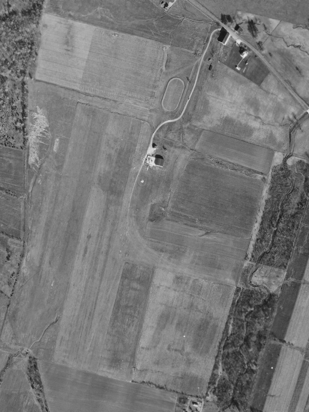
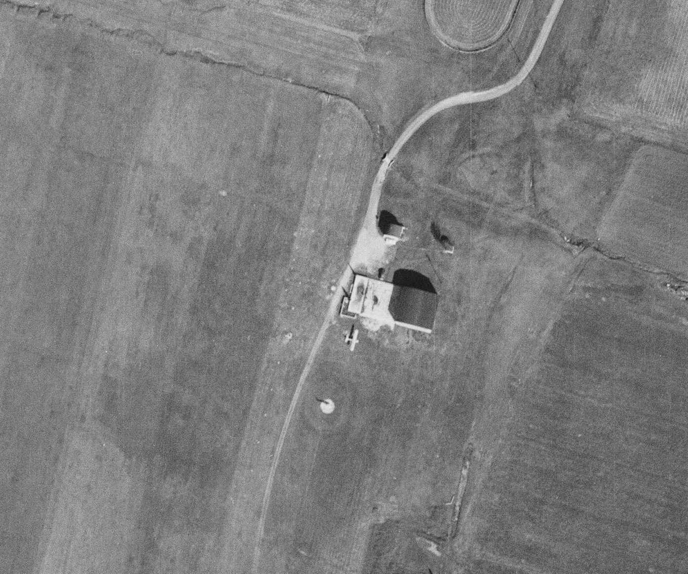
A circa 2010-2015 aerial view looking north at the hangar which remains at the site of the 2nd location of Gettysburg Airport.
A 2013 aerial view looking southwest at the site of the 2nd location of Gettysburg Airport,
showing the hangar remains intact, and the area of the runways remains clear.
The site of the 2nd location of Gettysburg Airport is located southeast of the intersection of Mummasburg Road & Russell Tavern Road.
Thanks to Geoff Sheen for pointing out this airfield.
____________________________________________________
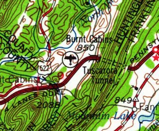
Burnt Cabins Landing Strip, Burnt Cabins, PA
40.08 North / 77.87 West (Southwest of Harrisburg, PA)
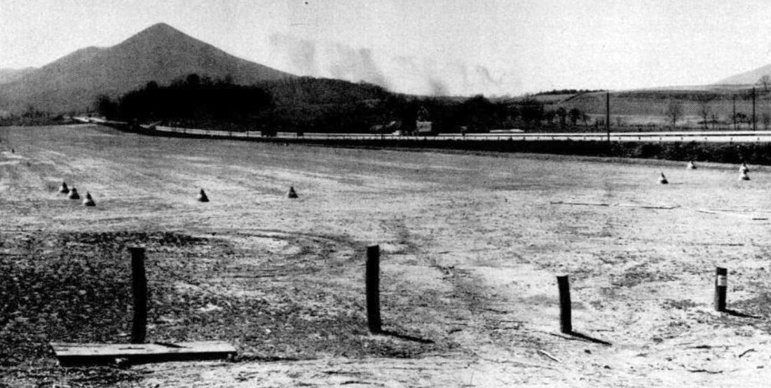
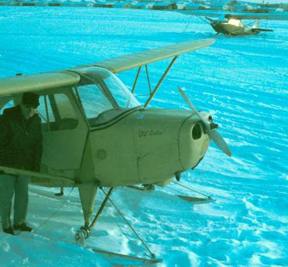
A undated photo from a July 1953 magazine article about the Burnt Cabins Landing Strip.
The date of construction of this small airfield adjacent to the southeast side of the Pennsylvania Turnpike has not been determined.
The earliest depiction which has been located of the Burnt Cabins Landing Strip was an undated photo from a July 1953 magazine article.
It depicted Burnt Cabins Landing Strip as a single grass runway marked with cones, adjacent to the Pennsylvania Turnpike.
Richard Ellers recalled, “Back in the late 1940s, I hitch-hiked across the Pennsylvania Turnpike.
I recall a trucker I was riding with telling me & showing me an emergency airfield alongside the turnpike.
He pointed out rows of pole-lights which would come on to guide airplanes.
That was back in the days when there were few airports.”
A 9/23/58 USGS aerial view depicted Burnt Cabins Landing Strip as a single grass northeast/southwest runway
parallel to the southeast side of the Pennsylvania Turnpike.
There did not appear to be any buildings at the airfield.
Burnt Cabins Landing Strip, as depicted on the 1961 USGS topo map.
Roy Netherton recalled, “The emergency strip at Burnt Cabins...
Though it was charted, I used to simulate engine failure during cross country training while that strip was clearly visible & within gliding range.
More than a few students picked it out as a good choice in the mountainous terrain
and since it was well maintained I would often let them proceed to a full stop landing there,
usually to their surprise since they seldom noticed it on the sectional.”
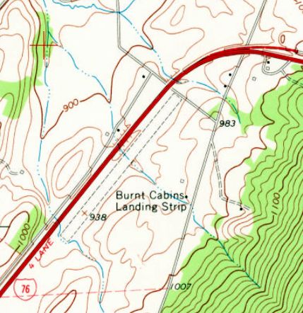
The 1966 USGS topo map depicted Burnt Cabins Landing Strip as a single unpaved northeast/southwest runway
parallel to the southeast side of the Pennsylvania Turnpike.
There were no buildings depicted at the airfield.
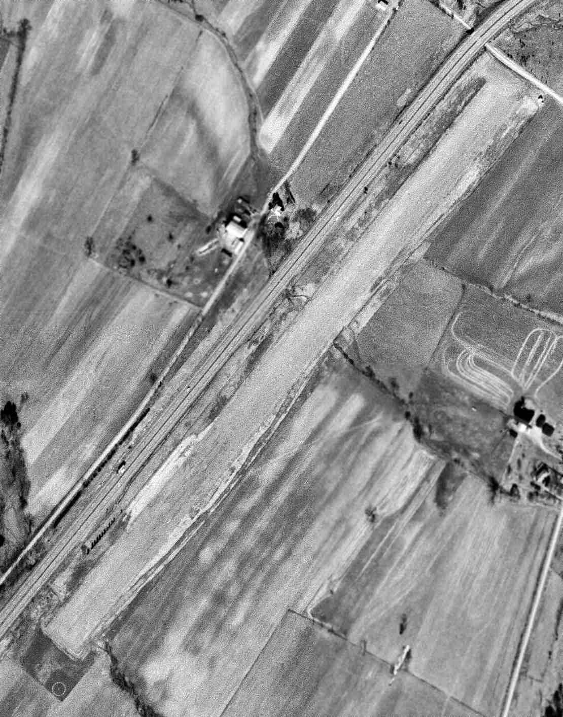
A 3/16/66 USGS aerial view depicted Burnt Cabins Landing Strip as a single grass northeast/southwest runway
parallel to the southeast side of the Pennsylvania Turnpike.
A segmented circle was adjacent to the southwest runway end.
Jim Hann recalled, “As a kid growing up and traveling this highway I remember a shack with a deteriorating windsock on the eastern corner of the field.”
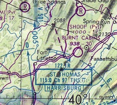
The only aeronautical chart depiction which has been located of the Burnt Cabins Airfield
was on the August 1976 Cincinnati Sectional Chart (courtesy of Mitchell Hymowitz).
It depicted Burnt Cabins as a public-use airport having a 3,000' unpaved runway.
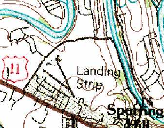
The 1985 USGS topo map still depicted a single runway, labeled simply as “Landing Strip”.
Jim Hann reported in 2008, “You can see the runway running right next to & parallel to the PA Turnpike.
The last time I passed the location this summer the shack was still there.”
A 2013 aerial view looking north shows the Burnt Cabins runway remains completely intact,
though without any sign of any recent aviation usage.
As of 2015, the Burnt Cabins Landing Strip was no longer depicted on aeronautical charts.
The site of Burnt Cabins Landing Strip is located south of the intersection of Pennsylvania Turnpike & Locke Road.
____________________________________________________
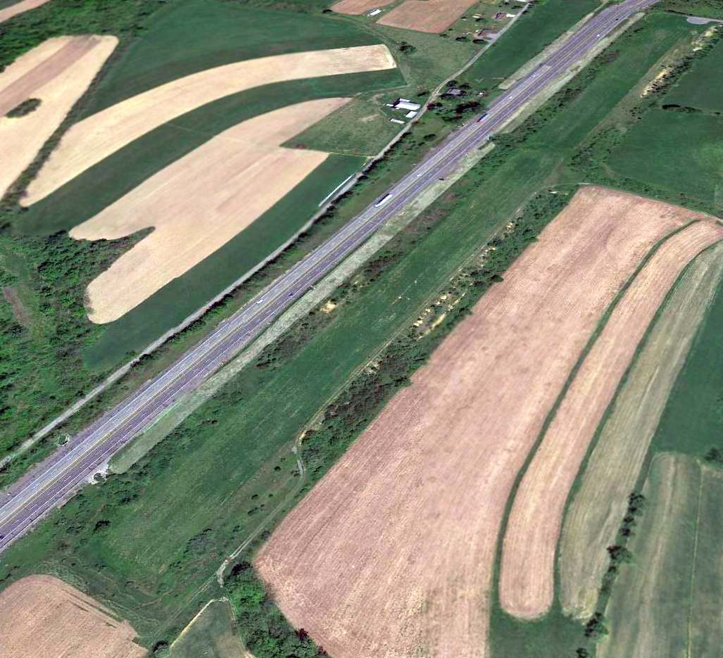
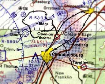
Chambersburg Airport / Sunset Airways Airport / Sunset Airport, Chambersburg, PA
39.98 North / 77.63 West (Southwest of Harrisburg, PA)
A February 1938 aerial view of the Chambersburg Airport.
This small general aviation airport was evidently established at some point between 1936-37,
as it was not yet depicted on the 1935 Washington Sectional Chart
nor listed in The Airport Directory Company's 1936 Airport Directory (according to Chris Kennedy).
According to Brian Fogal, Sunset Airport “was started by a man by the name of Ray Johns
(a local aviation legend, quite a few very interesting stories about this guy, I was lucky to know him well!).
Sunset was built after the closing of the first Chambersburg Airport called Brandon field
(now the location of Brandon Drive on the east side of Chambersburg near I-81 & Route 316).”
The earliest reference which has been located of the Chambersburg Airport at this location
was in The Airport Directory Company's 1937 Airport Directory (courtesy of Bob Rambo).
The directory described Chambersburg as a commercial airport located 3.5 miles northeast of the town.
It was said to consist of a 65 acre irregularly-shaped sod field,
within which were 3 runways, with the longest being the 2,500' north/south strip.
A hangar was located on the southeast side of the field.
The earliest depiction which has been located of the Chambersburg Airport at this location was a February 1938 aerial view.
It depicted the field as having 3 grass runways,
with a hangar along the southeast side of the field.
An undated aerial view looking north at the Chambersburg Airport
from The Airport Directory Company's 1938 Airport Directory (courtesy of Chris Kennedy).
The directory described the field as a commercial airport, consisting of a 65 acre irregularly-shaped sod field,
within which were 3 runways, with the longest being the 2,500' north/south strip.
A single hangar was pictured on the southeast side of the field,
which was said to be marked with “Chambersburg” on the roof.
The earliest aeronautical chart depiction which has been located of the Chambersburg Airport in this location
was on the August 1939 Washington Sectional Chart (courtesy of Chris Kennedy).
It depicted Chambersburg as a commercial/municipal airport.
The airport was evidently renamed “Sunset Airways” at some point between 1939-41,
as that is how it was labeled on the November 1941 Washington Sectional Chart (courtesy of Chris Kennedy).
It continued to be labeled as “Sunset Airways” on the May 1944 Washington Sectional Chart (according to Chris Kennedy).
Sunset Airways Airport was evidently closed for a period during WW2 (like many other small civilian airports),
as it was not depicted at all on the November 1944 Washington Sectional Chart (according to Chris Kennedy)
or the June 1945 Washington Sectional Chart (according to Chris Kennedy),
nor listed among active airfields in the 1945 AAF Airfield Directory (courtesy of Scott Murdock).
Chambersburg Airport was evidently reopened in 1945.
Jim Rosenberry recalled, “I took flying lessons (Piper Cub) at Chambersburg Airport which was owned by Bob Beard
who at that time was in the Army Air Corps flying C-46s over the hump in the CBI theater. My flight instructor was Harry Sellers.
Later in 1945 I started working for the proprietor of Sunset Airways, Jay Sollenberger.
My work consisted of washing, refueling & parking planes on weekends.”
An advertisement for Sunset Airways from the 1946 Chambersburg High School yearbook (courtesy of Jim Rosenberry).
Featured an undated aerial view looking south, showing the field to have 2 grass runways, with a small hangar & several light aircraft on the southeast corner.
Jim recalled, “I asked Jay [Sollenberger] to purchase an add in our 1946 yearbook & he graciously took a full page.
The inscription is from a friend of mine, Dick Kessinger, who was a year behind me in school & was the only other Chambersburg High School pilot at that time.
Dick flew his dad's Aeronca & I flew Jay's prized Taylorcraft.
One memorable trip with Jay was a flight to the Lock Haven factory to bring back a new J-3.
I knew Ray Johns, he was popular with the entire crowd & well respected.”
The airport evidently reopened as “Sunset Airport” by 1946,
as that is how it was labeled on the April 1946 Washington Sectional Chart (according to Chris Kennedy).
Sunset Airways Airport, as depicted on the 1948 USGS topo map.
A 1948 photo (courtesy of Brian Fogal) of a USAF C-47 at Sunset Airport.
Note the “Sunset Chambersburg” sign on the hangar.
According to Brian, “A person I meet some years ago gave [this picture] to me.
His Father was in the the Army & was returning home and somehow got a ride on this plane into Sunset.
They barely mad it in, and to get out they offloaded most of the fuel & all the cargo.”
The last photo which has been located showing Sunset Airport still in operation
was a 5/1/57 aerial view of Sunset Airport (from Penn Pilot).
It depicted the field as having 2 grass runways, with several hangars along the east side.
No aircraft were visible on the field.
A drive-in movie theater had been built along the southern edge of the property.
The last aeronautical chart depiction which has been located of Sunset Airport
was on the 1964 Washington Sectional Chart.
It depicted Sunset as having a 2,100' unpaved runway.
Sunset Airport evidently was closed at some point between 1964-65,
as it was no longer depicted on the January 1965 Washington Sectional Chart (according to Chris Kennedy).
According to Brian Fogal, “After it [Sunset Airport] closed
the Chambersburg Municipal Airport (now Franklin County Regional) was built in 1968.”
The 1968 USGS topo map depicted a drive-in movie theatre on the southern portion of the Sunset Airport site.
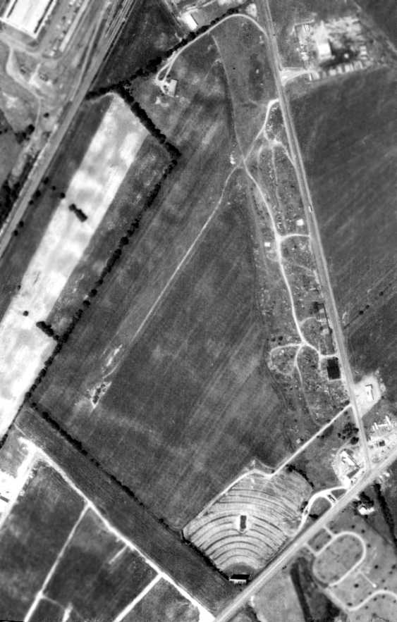
A 1970 aerial view of the site of the abandoned Sunset Airport showed the site to remain largely intact,
including several hangars along the southeast side of the field.
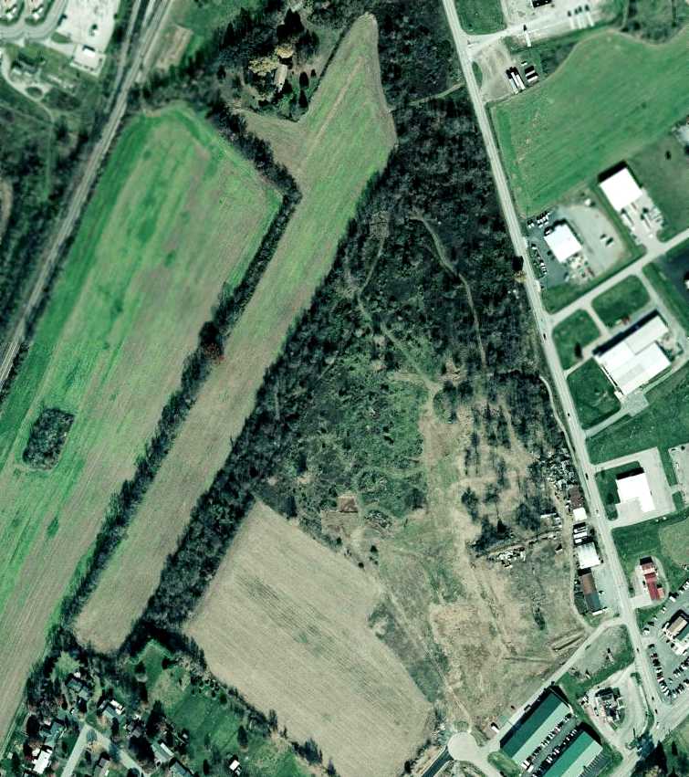
A circa 2006 aerial view shows that the site of Sunset Airport has not been redeveloped,
although trees have grown over the eastern portion of the field.
It appears as though one or more hangars may remain standing along the southeast side of the property.
The site of Sunset Airport is located west of the intersection of Route 11 & Sunset Pike,
appropriately enough.
____________________________________________________
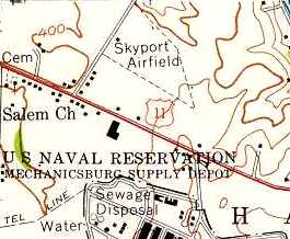
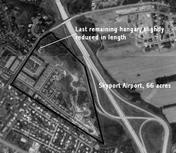
40.25 North / 76.98 West (West of Harrisburg, PA)
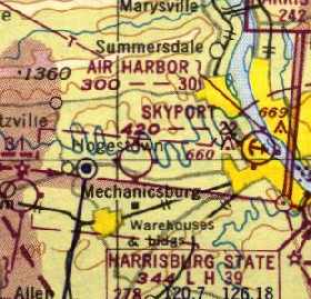
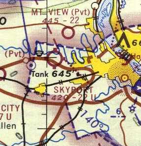
Skyport, as depicted on the 1950 NY Sectional Chart (courtesy of Mike Keefe).
Tom Beamer recalled, “Immediately after WWII Richard Weibly began building an airport on the family farm.
Local lore states that Skyport began operations as a private field in 1946.”
However, it was not yet depicted at all on the 1947 NY Sectional Chart (according to Tom Beamer).
Richard Weibley's daughter, Susan Weibley Adey, gave the opening date as 1949,
but this may actually have been the date at which commercial operations commenced at the field.
The earliest depiction of Skyport which has been located
was on the 1950 NY Sectional Chart (courtesy of Mike Keefe).
It depicted Skyport as having a 2,200' unpaved runway.
Tom Beamer recalled, “Shortly thereafter Dick became an Ercoupe dealer.
Dick Weibly (Uncle Dickie to the locals) was “Mr. Ercoupe”.
He was the most dedicated Ercoupe dealer in the country
and continued to sell new/used Ercoupes, Aircoupes, and Fornaires thru 1962.
During that time Dick became the premier developer & supplier of
modifications & parts for the Ercoupe/Aircoupe/Fornaire series.
Among Dick’s many modifications were: enlarged baggage compartment, large rear windows, bucket seats,
rudder pedals, vernier throttles, bubble windshield, split elevator, split fork nosegear, to name just a few.”
The 1956 USGS topo map depicted "Skyport Airfield" as having a triangular outline,
but did not depict any runways.
A single building was depicted on the west side of the field.
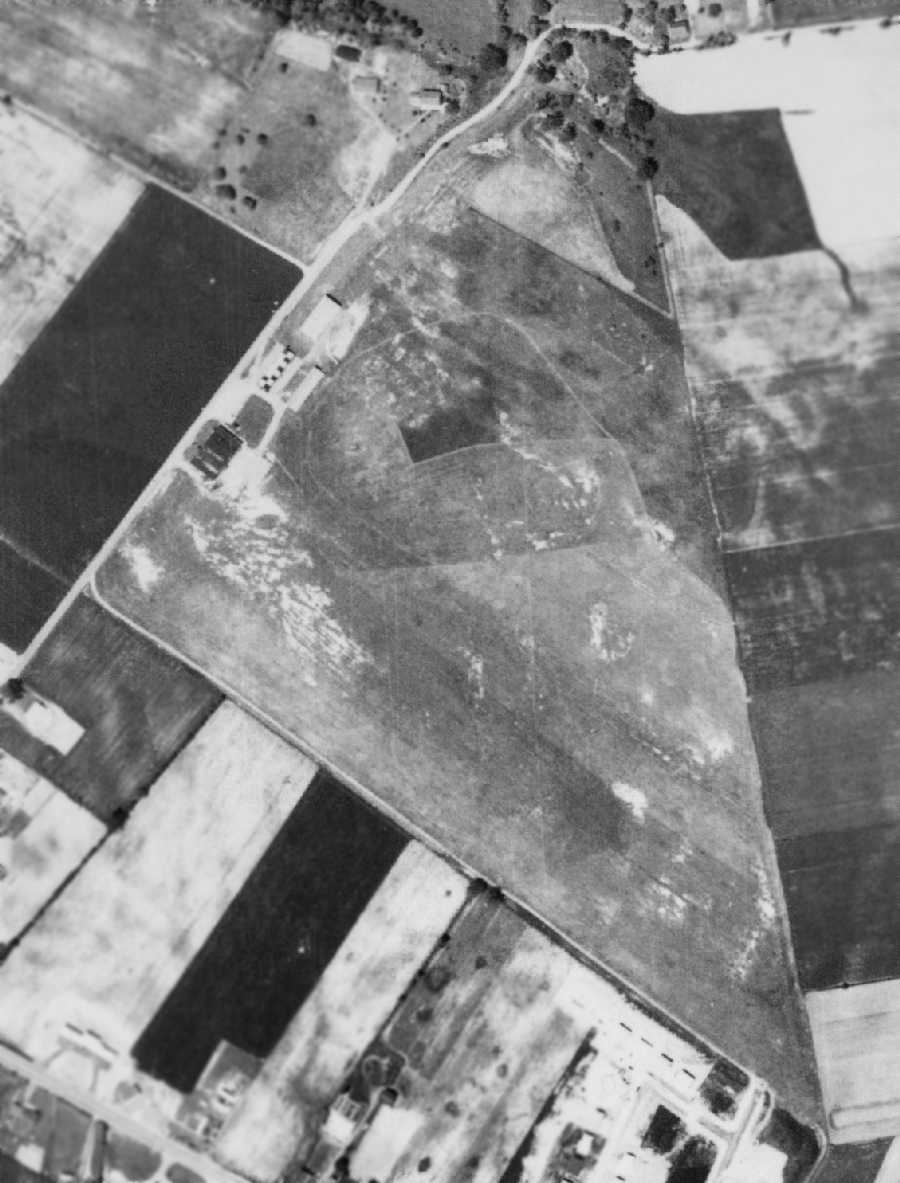
The earliest photo which has been located of Skyport was a May 27, 1958 aerial view (from Penn Pilot).
It depicted Skyport as having an open grass airfield area, with several small hangars along the northwest side of the field.
There were no aircraft visible on the property.
The 1962 AOPA Airport Directory described Skyport as having a total of 4 sod runways,
with the longest being the 2,176' Runway 18/36.
The field was said to offer charter, hangars, tiedowns, fuel, and major repairs.
The operator was listed as Richard Wiebley, who was also an Aircoupe dealer.
Tom Beamer recalled, “The airport operated as Skyport Airport, the parts/modification business as Skyport Ercoupe Services.
By 1962 the parts/modification business had grown to the point
that Dick moved it into the family barn across Skyport Road from the airport
and began looking for an operator to lease the airport.
Enter Howard Bartholomew Sr. (Bart) who had just retired from operating the Princeton (NJ) Airport & couldn't stay retired
[and who also previously operated the Budd Lake Airport in NJ].
So he & his son, H.R. Bartholomew Jr. (Bubby), became the new operators of Skyport in 1963.
While Dick's emphasis was on Ercoupes,
Bart's was on teaching basic stick & rudder flying in Aeronca 7AC Champs & operating the airport.
There was a main hangar with attached office on the north side,
and an attached shop on the south side, 2 sets of T-hangars, and one large common hangar.”
Tom Beamer recalled, “Bart operated the Fixed Base Operator under the name of Harrisburg Aviation.
In 1964 our fleet consisted of 2 Aeronca 7AC Champs, a Piper J-3 Cub,
two turtleback Cessna 172's, a turtleback Cessna 150, and an Ercoupe.
When Skyport closed the fleet had grown to seven Aeronca 7AC Champs,
three Omnivision Cessna 172's, and three Omnivision Cessna 150's.
During Bart's tenure the flight training emphasis was so great
that on a good day the traffic pattern looked like a textbook illustration with 6 of more planes doing landings, all full-stops.”
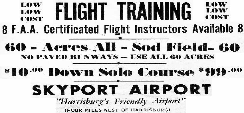
A circa 1964-68 ad for Skyport (courtesy of Tom Beamer).
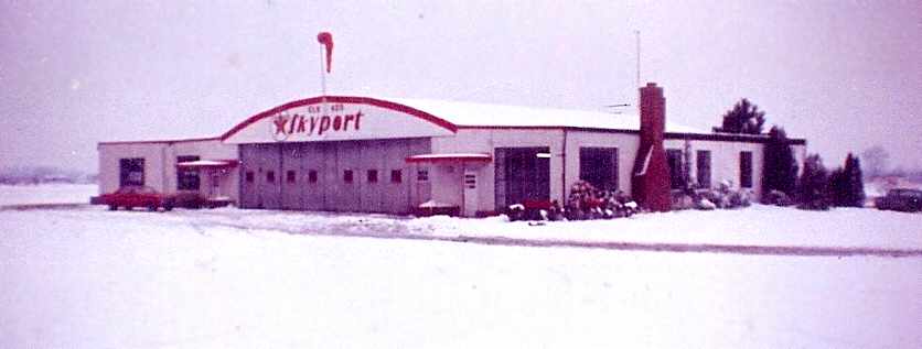
A 1965 photo by Tom Beamer of the Skyport hangar on a snowy day.
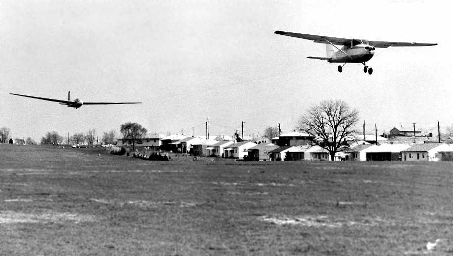
A circa 1964-66 photo by Brown Studio of a Cessna 170 performing a glider tow at Skyport (courtesy of Tom Beamer).
Tom recalled, “Yes you can tow a glider with a stock 172 from 2,200' if it's a single-seat.”

A 1966 photo by Tom Beamer of N585M in front of a Skyport hangar.
N585M was a 1929 DH Gypsy Moth that later went on to fame, starring in the movie "Out of Africa".
Tom recalled that it was the plane in “which I was sent out solo in the day I got my Commercial, it was also the first time I had ever sat in a biplane.”
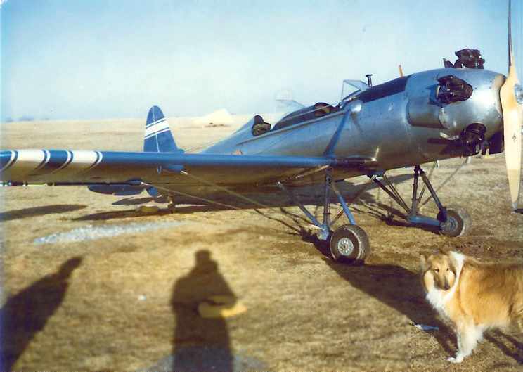
A circa 1960s photo by Tom Beamer of “Princess” in front of Bubby's Ryan PT-22 at Skyport.
Tom Beamer recalled, “The 1966 AOPA directory listed 4 runways,
but in reality we had only 2 runways in regular use:
2,200' northwest/southeast (primary) & 2,100' north/south with wires at the north end, by that date.
Pre-1964 more of the 66 acres (how many times did I cut all that grass?) were usable,
after that date expanding tie-down lines encroached into previously usable very short cross-wind runways.
Harrisburg Aviation provided full aircraft maintenance services, inspections,
repairs, fabric recover, we even offered half-day Ercoupe fabric wing exchanges for $1,000.
In the mid-1960’s, 80 Octane aviation gasoline was $0.30/gallon, and Sectional Charts were $0.35 each.
We rented the Cub/Champs for $8/hour solo & $12/hour dual,
the Ercoupe was $11/15, the 150’s $13/17, the 172’s $16/20.
We had a $99 Solo Course, in which the student paid for the first 8 hours & 15 minutes (at $12/hour)
and we gave them as much as 12 hours for no additional charge.
Most soloed in about 10 hours.
In the winter we installed skis on 2 Champs
and usually had a few students that needed a checkout on wheels when spring arrived having soloed on skis.”
The last depiction which has been located of Skyport on an aeronautical chart
was on the 1967 NY Sectional Chart (courtesy of Mike Keefe).
It depicted Skyport as having a 2,200' unpaved runway.
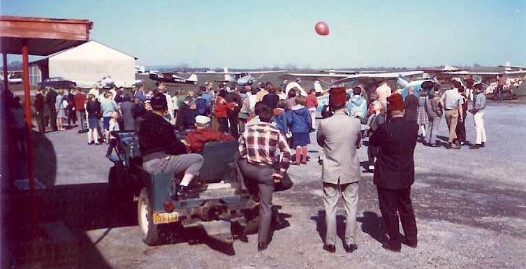
A 1967 photo by Tom Beamer of airplane rides being given for the Bethany Orphans Home at Skyport.
Tom recalled, “Bart had been in an orphanage...
every year when the orphans came to Harrisburg for the Shriner's Circus we took them all for rides,
everyone of our fleet and all of our local pilots were pressed to duty, a GREAT time was had by all...
in those pre-litigious times.”
Tom Beamer recalled, “During Bart’s tenure Skyport was like a club,
we were open from 8AM to dusk every day except Thanksgiving & Christmas.
Our customers and tenants often slogged through snow to sit in front of the huge fireplace
and hangar-fly for hours in the worst weather, or sit at the benches at the front door & grade landings in good weather,
or watch Bubby & I in the shop & ask questions or provide critique.
Bart was the club pro - always ready with a story or sage advice about aviation (politics, life, or one of his myriad of stories) -
drawing from his experience which began in the US Army Air Service
in the early 1920’s at Mitchell Field, where he learned to fly in a Jenny.
When Bart’s protégés meet we always share fond memories of the most memorable character any of us have met.
He was a FINE mentor to a 16 year old kid in love with aviation.”
A 1968 photo by Tom Beamer of N85544, an Aeronca Champ.
Tom recalled, “Skiplane ops were bitter cold, lousy heaters and with the poorly sealed doors it was brutal
BUT it kept customers coming through the door.”
Tom Beamer recalled, “Skyport was home to a number of interesting antiques:
the DeHaviland Gypsy Moth later used in 'Out of Africa', Waco UPF-7’s, a Kreider-Reisner Challenger, Fairchild 24,
Howard DGA-15, and Lil Audrey - which was Paul Poberezney’s first homebuilt & had began life as the famous Howard DGA-3 'Pete'.
At times it felt like we were in a time warp having returned to 1934 even though the calendar showed 1964.”
Tom Beamer recalled, “While encroaching suburban development doomed Skyport
the closure was accelerated by 5-10 years due to a feud that developed between 2 equally gifted but recalcitrant individuals
when the time came for Dick & Bart to renew the lease.
Harrisburg Aviation began to transfer to a new facility at Capital City Airport on 7/1/69.”
The last photo which has been located showing Skyport Airport still in operation was a 9/14/69 USGS aerial view.
It showed a total of 12 light aircraft on the field.
But also note the suburban encroachment adjacent to the field.
Tom Beamer recalled, “The official closing date was 11/31/69, when the airport license was canceled.
I made the last flight from Skyport on 2/28/70
when I ferried an out-of-annual Cessna 140 (N1625U) to another airport for a customer.”
Tom Beamer recalled, “While, at first glance, Skyport seems typical of many small post-WWII grass strips
it was far more active than most & a strong legacy continues due to Dick Weibly’s contributions to the Ercoupe fleet,
and Bart’s very active flight training program which seeded the Central PA area with so many new pilots,
and many memories of 2 very colorful characters.
It was an aeronautical Shangri-La.”
An 8/13/71 aerial photo showed the former Skyport Airport after its closure,
but before its redevelopment, when the field was still completely intact,
including the grass airfield area, and the hangars along the northwest side of the field.
There were no aircraft visible on the property.
According to the Village of Westover website (courtesy of John Coyne), “The airfield had been closed for several years
when, in 1971, a student pilot, looking for another airstrip on which to land,
mistook the old runway for another & came in too fast & too low, crashing into a home in Noll Acres.”
Skyport appeared to be closed as of 1978, as 2 runways were still depicted on the 1978 USGS topo map,
but the field was labeled simply as "Landing Strip".
By the time of the 1987 USGS topo map,
the area formerly occupied by Skyport was depicted merely as an open field.
The single building previously used by the airport (along the road, on the west side of the field) was still depicted, though.
Tom Beamer recalled, “Eventually Skyport was replaced by the fine townhouse & single-family development of Westover Village.
Skyport Road exits from Route 11, Stephen's Crossing is where the main runway was,
the northeast corner of Skyport Road & Stephen's Crossing was the site of the main hangar.”
The 1999 USGS aerial photo has been annotated by Tom Beamer to show the property outline of the former Skyport Airport.,
The eastern portion of the site of Skyport was obliterated by the construction of Route 581,
and housing was built over the western portion of the field.
A portion of a hangar appears to remain at the northern portion of the site.
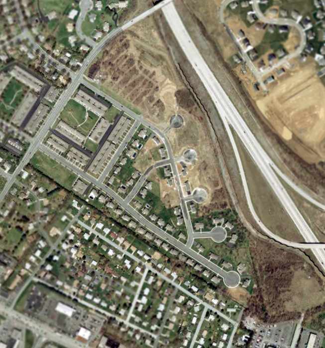
A circa 2002-2005 USGS aerial photo of the site of the former Skyport Airport.
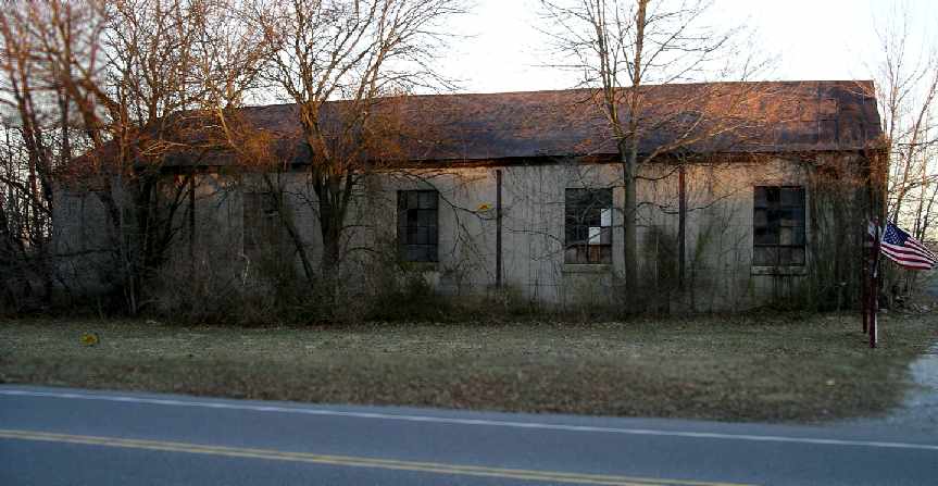
A 2005 photo by Tom Beamer of the former hangar which remains along the northern portion of the site of Skyport.
Tom Beamer reported in 2005, “All that remains is part of the common hangar which is in use by the subsequent developer.”
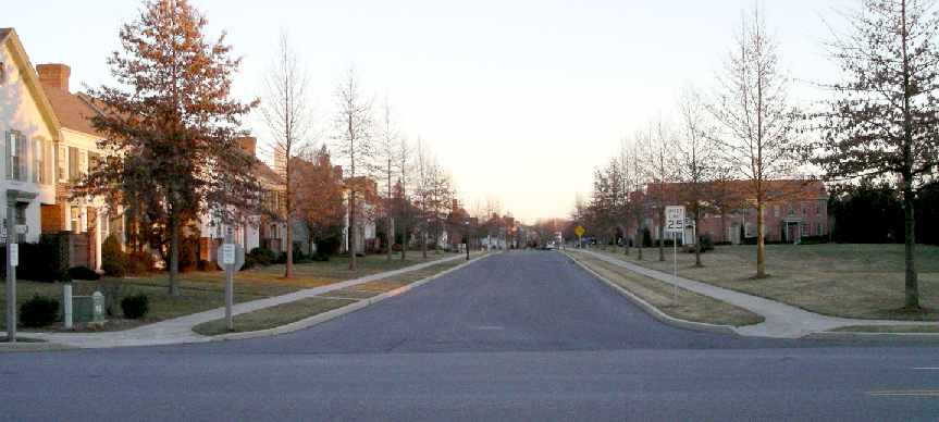
A 2005 photo by Tom Beamer, looking along the former runway alignment, now a housing development.
A circa 2006 aerial view looking north at the last hangar at the site of Skyport.
But seeing the housing construction on the right side of the photo, it appeared as if this hangar's days would be numbered.
Surely enough, a 1/17/12 photo by Scott Schuyler shows the remains of the Skyport hangar.
Scott observed, “Not only is the 'last standing hangar' now gone, there is absolutely NO trace of an airport remaining from ground level, and I suspect from the air either.”
The site of Skyport is located south of the intersection of Route 581 & Skyport Road,
appropriately enough.
Thanks to John McKissick for pointing out this airfield.
____________________________________________________
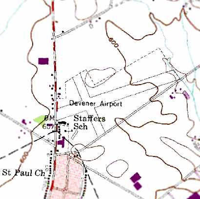
39.8 North / 76.98 West (Northwest of Baltimore, MD)
An 8/13/38 aerial photo depicted Devener Airport as having 2 grass runways,
with 2 small hangars on the southwest corner of the field, in front of which were parked 2 light aircraft.
The date of construction of this small general aviation airport has not been determined.
The earliest depiction of Devener Airport which has been located was an August 13, 1938 aerial photo.
It depicted Devener Airport as having 2 grass runways,
with 2 small hangars on the southwest corner of the field, in front of which were parked 2 light aircraft.
However, Devener Airport was not yet depicted at all
on the August 1939 Washington Sectional Chart (according to Chris Kennedy).
It may have been overlooked, as a relatively small airport.
The earliest aeronautical chart depiction of Devener Airport which has been located
was on the November 1941 Washington Sectional Chart (courtesy of Chris Kennedy).
It depicted Devener as a commercial/municipal airport.
The 1945 Washington Sectional Chart (courtesy of John Voss)
also depicted Devener as a commercial/municipal airport.
The 1947 Washington Sectional Chart depicted Devener Airport
as having a 2,000' unpaved runway.
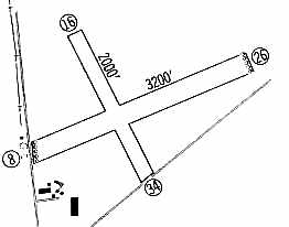
The Aerodromes table on the 1951 Washington Sectional Chart
described Devener as a commercial airport with 2 runways, with the longest being 3,200'.
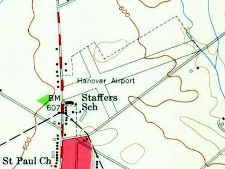
The 1954 USGS topo map labeled Devener Airport instead as “Hanover Airport”, but that may have been erroneous,
as there is no other source which has been located which used that name for this airport.
The 1960 Jeppesen Flight Manual (courtesy of Chris Kennedy)
depicted Devener Airport as having 2 unpaved runways: 3,200' Runway 8/26 & 2,000' Runway 16/34.
A few small buildings (hangars?) were depicted on the southwest side of the field.
The 1964 Washington Sectional Chart (courtesy of John Voss)
depicted Devener as a public-use airport having a 3,200' unpaved runway.
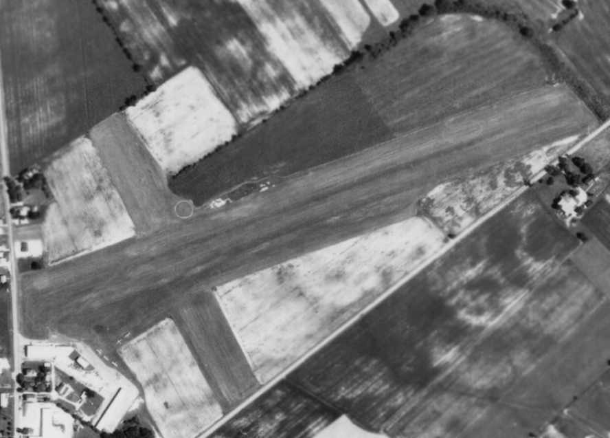
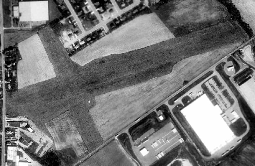
An 8/13/71 aerial photo of Devener Airport depicted the field as having 2 grass runways,
with an airport circle marking just north of the runway intersection.
A total of 5 light aircraft were visible parked alongside the hangars on the southwest side of the field.
The last aeronautical chart depiction which has been located of the Devener Airport
was on the March 1977 Washington Sectional Chart (courtesy of Chris Kennedy).
It depicted Devener as a public-use airport having a 3,200' unpaved runway.
According to an article in the 1/28/66 issue of the Gettysburg Times was entitled “Hanover Man Is Killed In Plane Crash.”
It reported that “Raymond Devener, 60, owner of Devener Airport...
was 1 of 3 persons killed Thursday in the crash of his private plane
which had been prevented from landing at Port Erie airport by poor visibility.”
The 2/25/75 issue of the Gettysburg Times included an advertisement which read,
“Learn to fly now at Rohrbach Aviation, Devener Airport, Route 195, Hanover.
Personalized instruction at anti-inflation rates.”
The 1984 USGS topo map depicted Devener Airport as having 2 unpaved runways,
with several buildings (hangars?) on the southwest side of the field.
Devener Airport was still listed in the “Low Use Airports” section of the 1986 Flight Guide (according to Chris Kennedy).
A 1992 NTSB report described a 1988 incident in which a pilot was cited for operating his aircraft at an unsafe (low) altitude
before landing his plane at Devener Airport.
The Devener Airport evidently closed (for reasons unknown) at some point between 1986-93,
as it was no longer depicted at all on the March 1993 Washington Sectional Chart (courtesy of Carl Taylor).
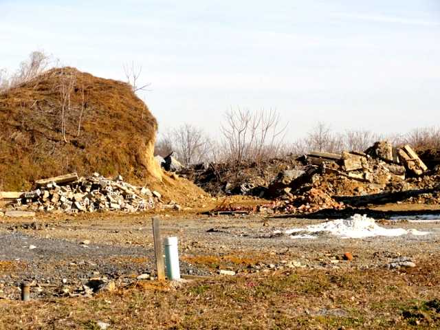
As seen in the 1999 USGS aerial photo,
the 2 grass runways remained intact, along with several buildings on the southwest side of the field.
There were no aircraft visible on the field, though,
nor any other sign of recent aviation use.
An article by Christina Kristofic in the 9/18/04 issue of the Hanover Evening Sun was entitled “Developer eyes Devener Airport”.
It read, “The old Devener Airport property might see some new use in the future.
Regional Homes LLC, a development firm based in Owing Mills, MD,
wants to purchase part of the property & build an age-restricted development.
The 70-acre property, located in Penn Township between Broadway and Moulstown Road,
is currently divided into 3 zoning districts, according to Penn Township manager Jeff Garvick.
The western portion - 12 acres - is zoned commercial,
the middle portion - 41 acres - is zoned industrial
and the remaining 16 acres in the eastern portion of the property is zoned residential.
CDL Investors, of Hanover, owns the property,
but Regional Homes has a ratified purchasing contract on the middle & eastern portions of the property,
said Eric Levitt, part-owner of Regional Homes.
Levitt said he wants to rezone the middle portion from industrial to residential to build a retirement-type community.”
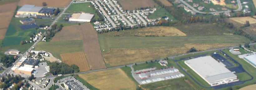
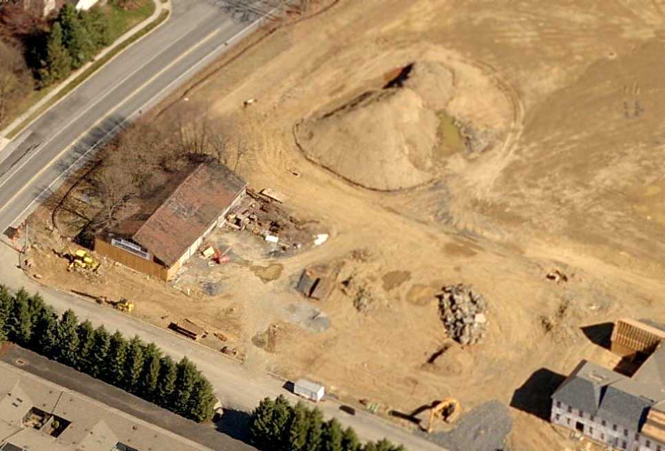
A 2006 aerial photo by Paul Freeman, looking north at the runways of the former Devener Airport.
A 2006 aerial photo by Paul Freeman, looking northwest at the former hangar & ramp of the former Devener Airport.
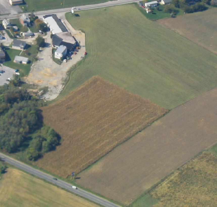
A circa 2010 aerial photo looking south at the former hangar & ramp which remain at the site of Devener Airport.
Devener Airport is located northeast of the intersection of Broadway & Moulstown Road.
____________________________________________________
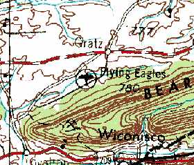
Gratz Airfield / Bressler Airfield / Flying Eagles Airfield, Gratz, PA
40.61 North / 76.74 West (Northeast of Harrisburg, PA)
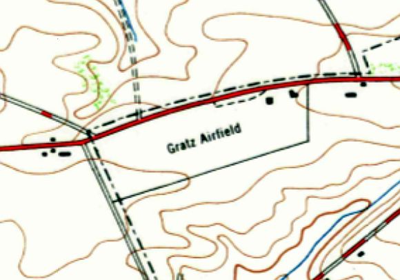
Gratz Airfield, as depicted on the 1947 USGS topo map.
This small general aviation airport was evidently established at some point between 1945-47,
as it was not yet depicted on the 1944 USGS topo map nor on the 1945 NY Sectional Chart.
The earliest depiction which has been located of Gratz Airfield was on the 1947 USGS topo map,
which depicted Gratz Airfield as an unpaved east/west airfield with 2 small buildings on the northeast corner.
It was evidently renamed Bressler Airfield at some point between 1947-50,
as that it how it was labeled on the 1950 NY Sectional Chart (courtesy of Mike Keefe).
Bressler was depicted as having a 2,400' unpaved runway.
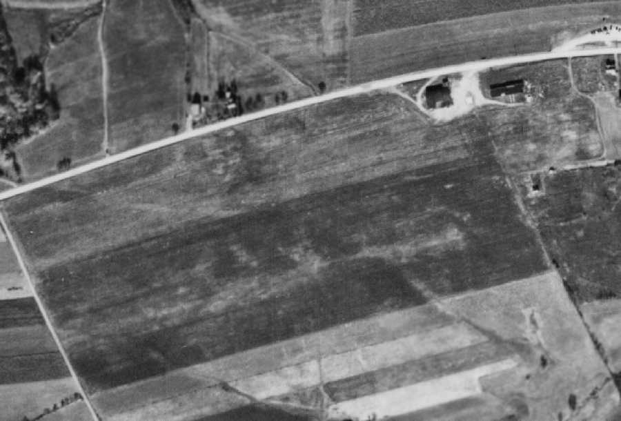
The earliest photo which has been located of Bressler Airport was a 10/25/56 aerial view (from Penn Pilot).
It depicted the field as having a single east/west grass runway,
with hangar & a few other small buildings on the northeast side of the field.
No aircraft were visible on the field.
Bressler Airfield may have closed at some point between 1950-58,
as it was no longer depicted at all on NY Sectional Charts from 1958-67.
At some point between 1967-69, the airfield was evidently reopened as “Flying Eagles” Airfield,
as that is how it was labeled on the 1969 USGS topo map.
Note however the somewhat erroneous location of the airport symbol
(southwest of Gratz, as opposed to its true location due west of the town).

A July 7, 1970 aerial photo of Flying Eagles Airfield depicted the field as having a single east/west grass runway,
with hangar & a few other small buildings on the northeast side of the field,
near which were visible 2 light aircraft.
According to Gary Bopp, “The airport... was a single runway grass field.
I know it was still in use in 1971. I think it closed in the mid-1970s.”
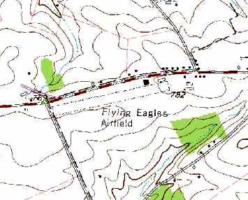
However, “Flying Eagles Airfield” was still depicted on the 1987 USGS topo map.
It depicted the field as having a single 2,100' east/west unpaved runway,
with a single building on the northeast side of the field.
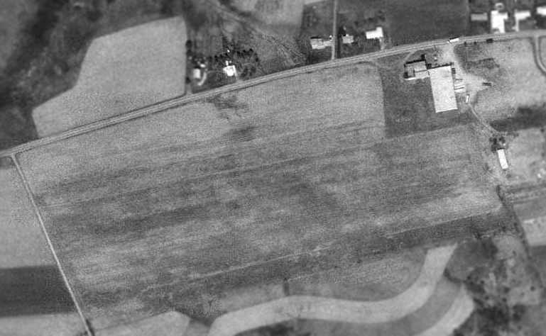
The 1993 USGS aerial photo depicted the airfield remaining completely intact,
including the grass runway, and the hangar at the northeast corner of the field.
Flying Eagles Airfield was still depicted on the 1999 USGS topo map.
However, Gary Bopp reported in 2005, “The airport is gone now.
The site has been built up with industrial buildings.
I believe the original hangar is still there & being used as a window factory.”
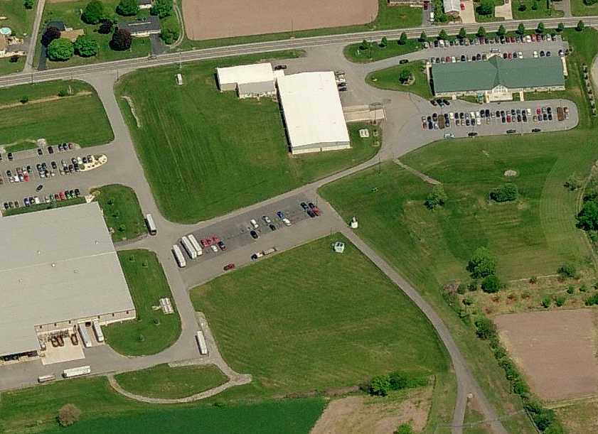
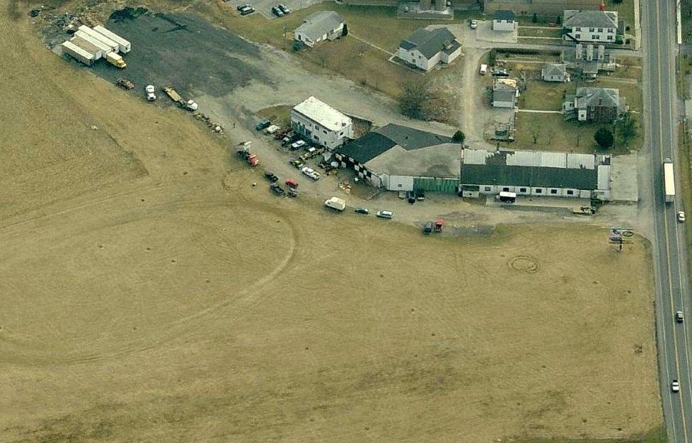
A circa 2006-2010 aerial view looking north at what may be a remaining hangar at the site of Flying Eagles Airfield.
The site of Flying Eagles Airfield is located southeast of the intersection of Lykens Valley Road & Airport Road,
appropriately enough.
____________________________________________________
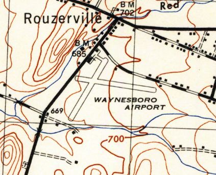
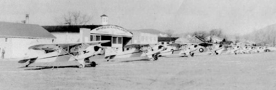
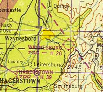
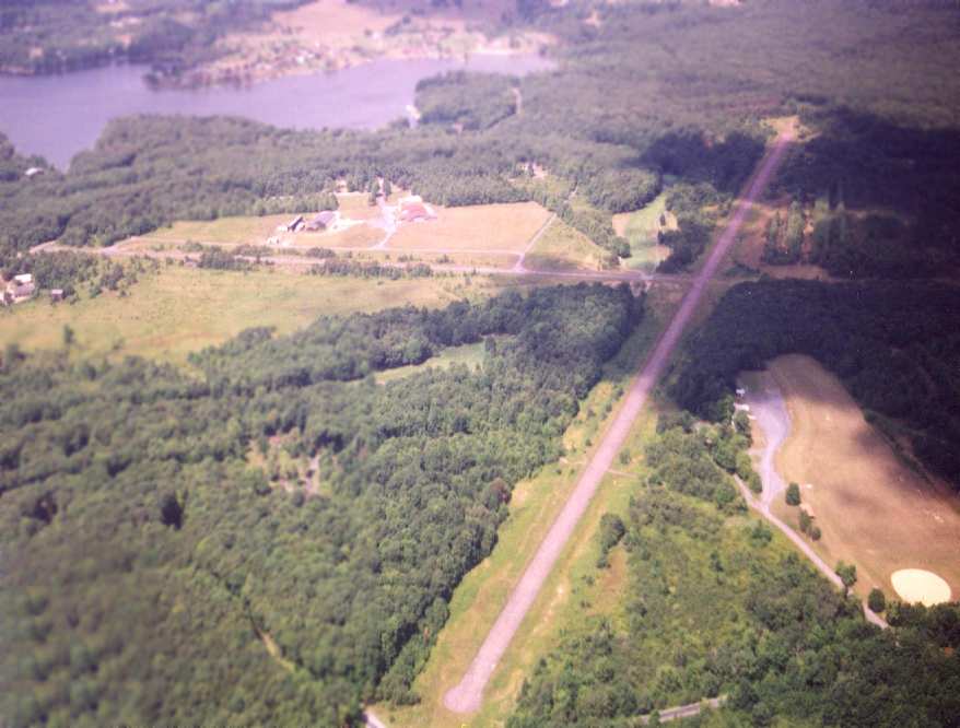
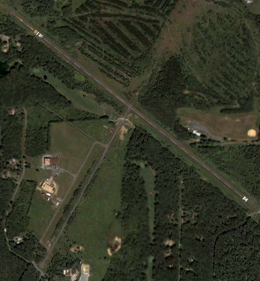
Worley Field / Waynesboro Airport, Waynesboro, PA
39.73 North / 77.53 West (Northwest of Baltimore, MD)
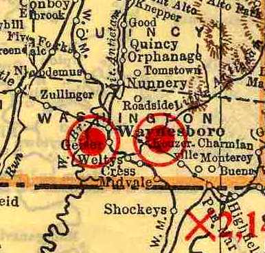
What apparently eventually became Waynesboro Airport
was depicted as "Worley Field" (the eastern of the 2 fields in the center of the map)
in the 1929 Rand McNally "Standard Indexed Map With Air Trails" (courtesy of Chris Kennedy).
The earliest reference to an airfield at this site which has been located
was in the 1929 Rand McNally "Standard Indexed Map With Air Trails" (courtesy of Chris Kennedy).
It depicted a "Worley Field" as being located "2 miles east" of Waynesboro.
It was described as being operated by G. W. Worley, and the field measured 1,200' x 1,100'.
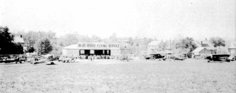
A 1930 photo (courtesy of Colin Heefner) of the opening of Waynesboro Airport,
showing at least 4 biplanes & 3 monoplanes in front of the Blue Ridge Flying Service hangar.
According to Colin Heefner, “The airport which is now located east of Waynesboro near the village of Rouzerville
was opened on Memorial Day 1930.”
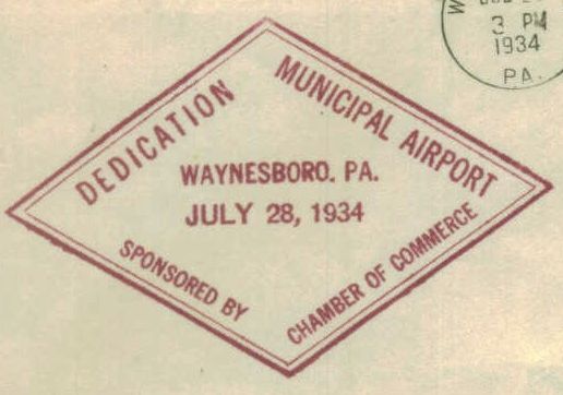
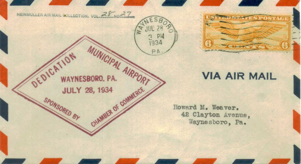
A postmark commemorated the 7/28/34 Dedication of Waynesboro Municipal Airport.
The 1934 Department of Commerce Airport Directory (according to Chris Kennedy)
described the "Waynesboro" Airport as having 4 sod runways,
with the longest being a 2,600' east/west strip.
The 1935 Washington Sectional Chart depicted Waynesboro Airport as a municipal or commercial airport.
According to Colin Heefner, “On 12/19/35, in a session of Borough Council,
Airport Manager Pottorff discussed proposed improvements
and suggested Work Progress Administration Federal Funds be obtained for that purpose.
The grant for $78,000 was received.
To this was added $4,500 from the sponsor, making the total project $82,500.
Another grant was obtained to cover wage increases.
This grant was in the amount of $16,000,
so nearly $98,500 was spent on making this airport one of the best in the east.”
According to Colin Heefner, “On the west side of the field a new 80' x 100' concrete block hangar was built.
The front was faced with brick.
It was built next to the old existing hangar which was 60' x 60' steel hangar,
each of which had a 30' concrete apron running the full length of the structures.
Adjoining the aprons was an 80' x 350' taxi strip connecting the hangars.
The 2 runways at this time were changed from turf to hard-surfaced runways.
The new block hangar contained a 20' x 60' workshop, offices & other airport conveniences.
An approved beacon light was mounted atop the hangar
and a complete set of airport boundary lights installed on the runways.
The airport with all of its new additions & updates had its formal opening on July 24, 1937.”
The Airport Directory Company's 1937 Airports Directory (courtesy of Bob Rambo)
described Waynesboro Municipal Airport as having a total of 3 sod runways,
with the longest being a 2,600' east/west strip.
A hangar (with "Waynesboro Airport" painted on the roof) was described as being on the northwest side of the field.
A 4/20/37 aerial photo looking west depicted Waynesboro as having 2 hangars at the northeast corner of the field.
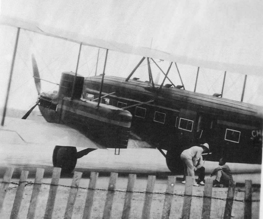
A 1937 photo (courtesy of Colin Heefner) of a massive Curtis Condor biplane which was landed at Waynesboro Airport by Col. Clarence Chamberland.
The plane had landed at Waynesboro on 11/26/37 after a trip from Hamburg, Germany,
and took passengers on sightseeing trips.
The runways at Waynesboro were apparently paved within the next year,
as The Airport Directory Company's 1938 Airports Directory (according to Chris Kennedy)
described the field as having 2 hard surfaced runways (2,050' east/west & 1,800' north/south), "Each 100' in width."
A 4/20/38 aerial photo depicted Waynesboro as having 2 paved runways,
with a hangar on the northwest corner of the field.
According to Colin Heefner, “The airport was taken over in 1942 by Malcolm Hardy
and was used as a Primary Training facility for Pilot Training of World War II pilots.
These pilots were housed at Mount St. Mary's College in Emmitsburg, MD.”
The 1944 USGS topo map depicted Waynesboro Airport as having 2 paved runways, with 2 buildings on the northwest corner.
The 1944 US Army/Navy Directory of Airfields (courtesy of Ken Mercer)
described Waynesboro as having a 2,000' hard-surface runway,
and it indicated that both Army & Navy operations were conducted from the airfield.
A 1944 photo (courtesy of Colin Heefner) of a 9 Cubs in front of the Waynesboro Airport hangar, part of a wartime training program.
According to Tom Beamer, a 1945 AAF installations directory indicated that Waynesboro was one of 3 airports
under the control of the Office of the Commanding General of the Army Air Forces during WW2.
That was presumably due to Waynesboro's proximity to Fort Richie and/or Camp David.
For a civil airport located in a small town,
Waynesboro had a relatively elaborate runway configuration,
with 2 paved intersecting runways.
This may have been due to its military connection,
or due to improvements performed by the WPA at Wayenesboro.
The 1945 AAF Airfield Directory (courtesy of Scott Murdock) described Waynesboro Municipal Airport
as a 60 acre irregularly-shaped property within which were 2 macadam runways, measuring 2,040' east/west & 1,740' northeast/southwest.
The field was said to have 3 concrete & steel hangars, the largest being a 212' x 30' structure,
and to be privately owned & operated.
Colin Heefner recalled of Waynesboro Airport, “I was first employed there in May of 1946 as Line Boy.”
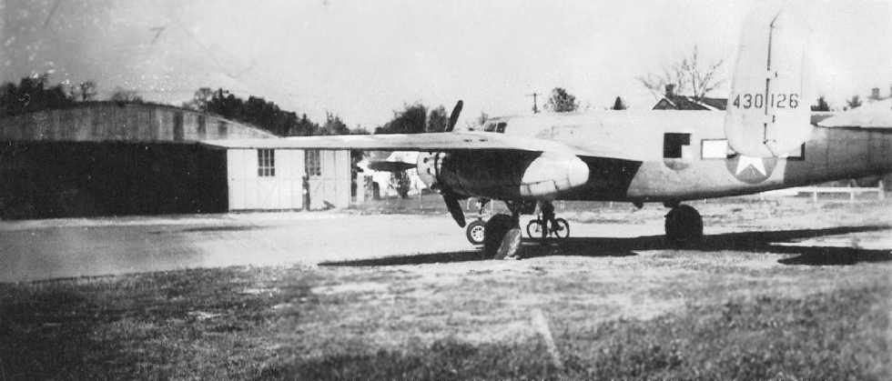
A November 1946 photo (courtesy of Colin Heefner) of an Army Air Forces North American B-25 Mitchell bomber which landed (why?) at the Waynesboro Airport.
The 1947 Washington Sectional Chart depicted Waynesboro Airport as a municipal or commercial airport.
Waynesboro was still depicted as an active airport
on the 1949 Washington Sectional Chart (courtesy of Mike Keefe).
According to Colin Heefner, “At the end of World War II flight instruction continued to show a need for pilot training.
This was supplemented by the approved GI Bill
for GIs getting out of the service & wanting to continue their goals towards a career in commercial aviation.
The government however rescinded the GI Bill Training around 1949 because the Bill was being abused.
This became the demise of the Waynesboro Airport.”
The last photo which has been located of Waynesboro Airport while it was operational
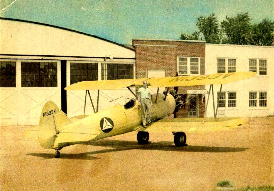
was a 1950 photo of Colin Heefner on top of a Civil Air Patrol Stearman in front of the Waynesboro hangar.
According to an article in the 6/22/94 Waynesboro Record Herald (courtesy of Colin Heefner),
“In early February 1950 Mr. Hardy [airport owner] offered the airport runways, one 2,200' long, the other 1,800' long & both 100' wide,
to the Borough for $17,000.
He would then pay them annually $850, on a year-to-year basis,
and continue to operate the field.
The hangars & other buildings were not part of the proposal.
The money received from the runway sale would be applied to his indebtedness.
Should Council turn it down, then he was ready to 'plot the tract & enter the real estate business.'
And that is what happened.”
Colin Heefner recalled, “I was the last employee to work at the Waynesboro Airport.
The field was officially closed in the Fall of 1950 by Pennsylvania Aeronautics Standards
and at that time the 2 hard-surface runways were X'd off.
I terminated my employment there in August of 1951.”
According to an article in the 6/22/94 Waynesboro Record Herald (courtesy of Colin Heefner),
“Hardy
divided & sold the airport land soon thereafter.”
Waynesboro Airport was no longer depicted at all on the 1953 Flight Chart,
and it was labeled "Abandoned airport" on the 1960 Washington Sectional Chart (courtesy of Mike Keefe).
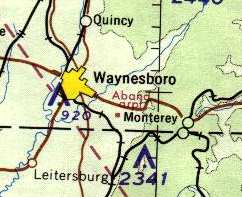
The site of the former Waynesboro Airport,
labeled "Aband arpt" on the 1964 Washington Sectional Chart (courtesy of John Voss).
According to Debbie Ragno, “The company I work for [Homes by Keystone, Inc.] opened on this site in 1966.”
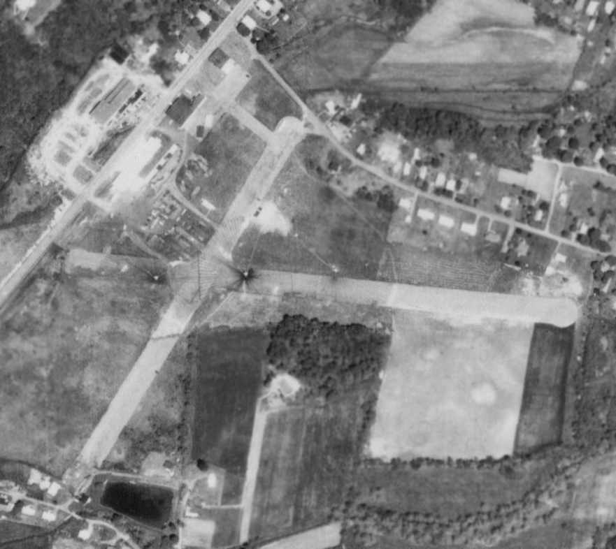
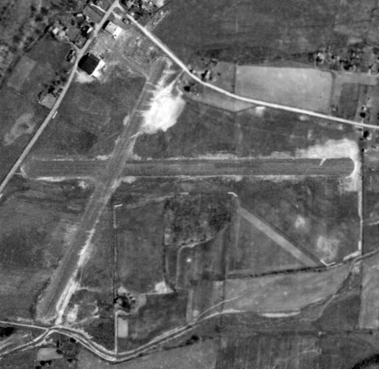
A 5/18/71 aerial photo of the former Waynesboro Airport depicted the field as mostly intact,
with housing covering a small portion of the northeast/southwest runway,
but the 2 runways were otherwise intact, as was the former hangar.
USGS maps of the site from 1981-89 did not depict the former airfield at all.
The former hangars were still depicted on the 1989 USGS topo map, but not the former runways.
In the 1994 USGS aerial photo, the outline of 2 former paved runways was still very recognizable.
The 2,000' east/west runway still existed in its entirety.
A southwest portion of the slightly shorter northeast/southwest runway had been removed.
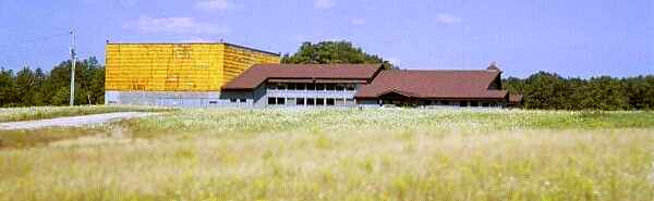
Two large buildings sat northwest of the former runway intersection,
one of which is the former airport hangar.
According to an article in the 6/22/94 Waynesboro Record Herald (courtesy of Colin Heefner),
“The site is now occupied by Keystone Homes Inc., builder of modular housing.”
Debbie Ragno reported in 2003, "I am an employee of Homes by Keystone, Inc.,
which now owns the former airport property."
She reported that the former hangar is currently reused as a storage building for supplies.
Debbie reported, “I look directly at the old airport hangar every day from my desk in the front office.
We have a painting by local artist Landis Whitsel hanging in our front office
of the airport as it appeared in the 1940s (Mr. Whitsel is also a pilot as well as an artist).
At least one of the runways are still there, as well as the old hangar.
As for… the runways… they are crumbling rapidly.
I think that on one we have a number of home sections parked waiting for delivery."
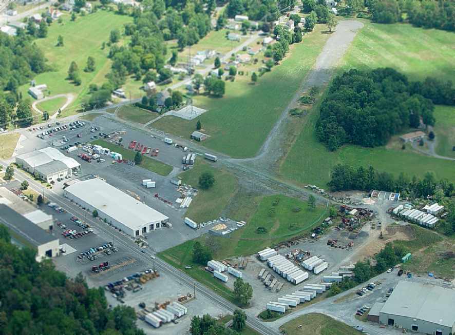
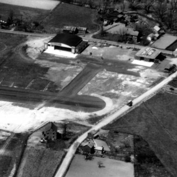
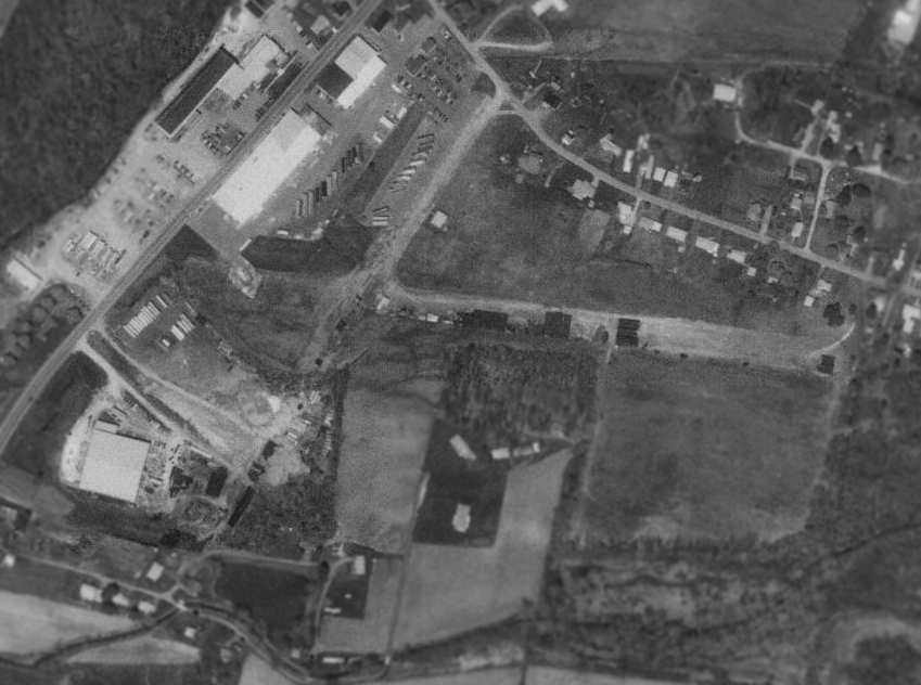
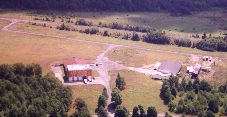
An August 2006 aerial view by Colin Heefner looking east at the remaining runways & hangars at the former Waynesboro Airport.
Colin reported, “The Waynesboro Airport has so much aviation history.
It surprises me to walk up to people on the street that don't even know that an airport ever existed here.
It was to me being able to participate in my childhood, working there, a memory that only I can enjoy & never allow it to be erased.”
A circa 2010 aerial view looking north at the remaining runways & hangars at the site of Waynesboro Airport.
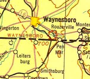
A clue as to what used to occupy this site is given by the name of the road
which runs across the northern edge of the property - Airport Road.
The site of the Waynesboro Airport is located southeast of the intersection of Airport Road & Midvale Road.
____________________________________________________
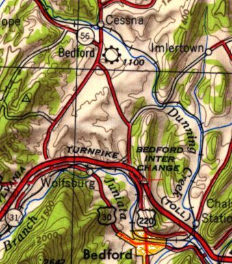
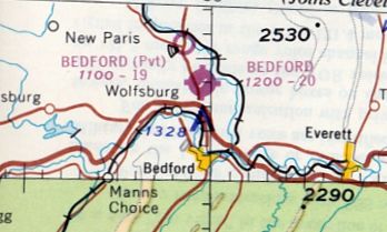
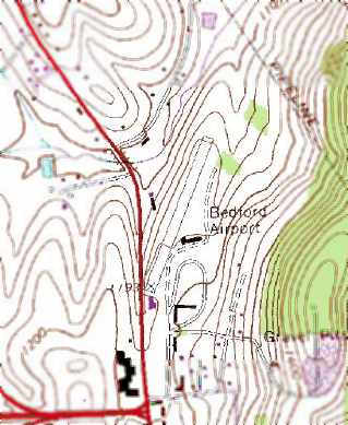
Bedford Airport (1st location), Bedford, PA
40.02 North / 78.49 West (Northwest of Hagerstown, MD)
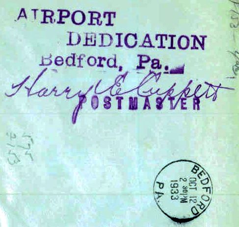
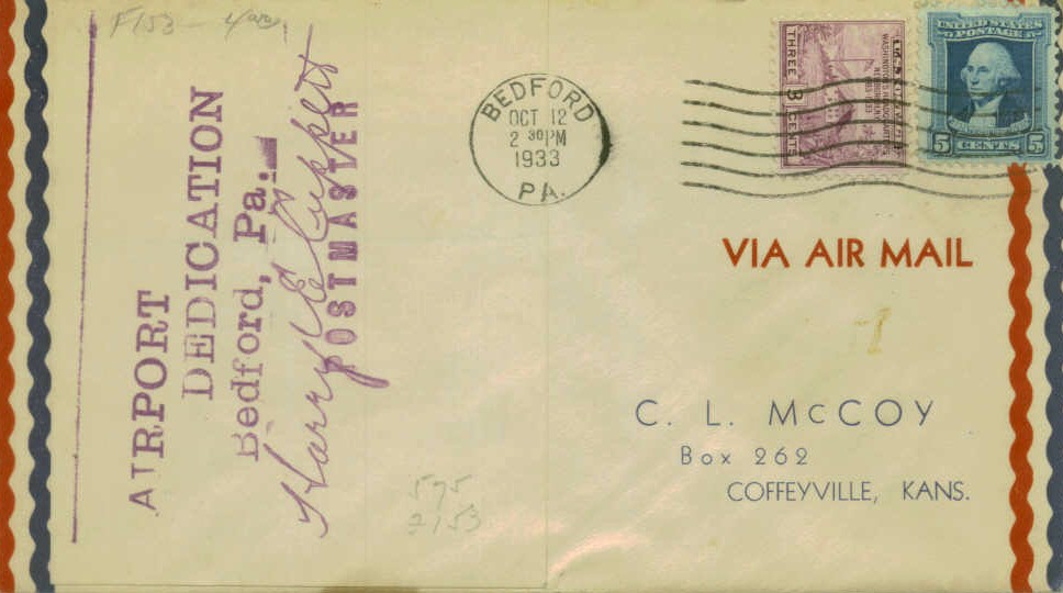
A postmark commemorated the 10/12/33 Dedication of Bedford Airport.
Photo of the airfield while in use has not been located.
The little town of Bedford has had an airport at no less than 4 different locations within the period from 1934-89.
Bedford Airport was not yet depicted on the April 1933 Cleveland Sectional Chart.
A postmark commemorated the 10/12/33 Dedication of Bedford Airport.
The earliest directory listing which has been located of Bedford Airport
was in the 1934 Department of Commerce Airport Directory (according to Chris Kennedy).
It listed Bedford Airport as being located 0.75 miles northeast of the town of Bedford, parallel to U.S. Highway 30.
The field was described as having 2 sod runways, with the longest being an 1,800' northwest/southeast strip.

The only aeronautical chart depiction which has been located of the original Bedford Airport
was on the February 1935 Cleveland Sectional Chart, which depicted Bedford as an auxiliary airfield.
The original Bedford Airport may have been closed at some point between 1935-37,
as no Bedford Airport was listed in The Airport Directory Company's 1937 Airports Directory (courtesy of Bob Rambo).
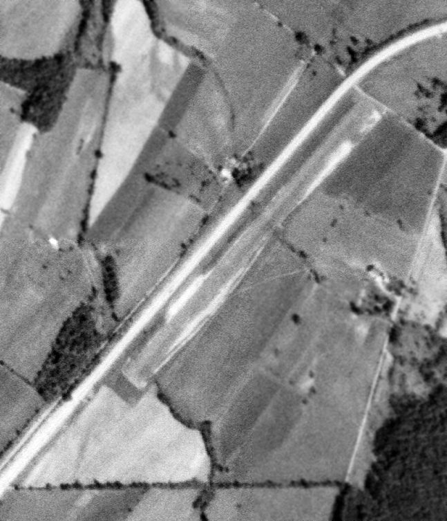
Nothing recognizable as an airport was depicted at the site of the original Bedford Airport on an 4/5/39 aerial photo.
No airfield in Bedford was depicted on the March 1940 Cleveland Sectional Chart.
From 1947 onward, a new Bedford Airport operated at a different location,
2 miles to the north, in the town of Cessna.
As seen in the 1993 USGS aerial photo,
the site of the original Bedford Airport has been covered by several large buildings,
and not a trace of the airfield appeared to remain.
The site of the original Bedford Airport is evidently located northeast of the intersection of Route 30 & North Anderson Street.
____________________________________________________
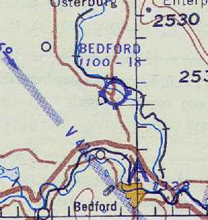
Bedford Airport (2nd location), Cessna, PA
40.09, -78.52 (Northwest of Hagerstown, MD)
The 2nd location of the Bedford Airport, as depicted on the July 1947 Cleveland Sectional Chart.
Photo of the airfield while in use has not been located.
The 2nd location of the Bedford Airport was evidently established at some point between 1945-49,
as no Bedford Airport was yet listed in the 1945 Haire Publishing Company Airport Directory (according to Chris Kennedy)
nor in the 1945 AAF Airfield Directory (courtesy of Scott Murdock).
The earliest depiction which has been located of the 2nd location of Bedford Airport was on the July 1947 Cleveland Sectional Chart.
The 1949 Cleveland Sectional Chart (courtesy of Chris Kennedy)
described the Bedford Airport as having an 1,800' unpaved runway.
According to Gary Bopp, this Bedford Airport was located
along US 220 (which has since become Interstate 99) at the intersection of PA 56 in the Village of Cessna.
The 1953 USGS topo map depicted the 2nd location of Bedford Airport as south of the town of Cessna.
The 1957 PA Aeronautical Chart (courtesy of Mike Keefe) depicted the Bedford Airport as having 2 runways:
an 1,810' northwest/southeast shale strip, and a 1,595' northeast/southwest turf strip.
The operator was listed as Blair-Bedford Airways, and the manager was F. Grazier.
The January 1958 Cleveland Sectional Chart (courtesy of Chris Kennedy)
depicted the Bedford Airport as having an 1,800' unpaved runway.
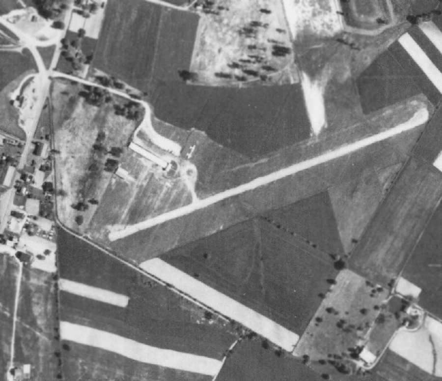
The earliest photo which has been located of the 2nd location of the Bedford Airport was a 5/22/58 aerial view (from Penn Pilot).
It depicted the field as having a single paved northeast/southwest runway.
Two small buildings were located on the west side of the field, along with 2 light aircraft.
At some point between 1958-62, a replacement Bedford Airport (the airport's 3rd location)
was constructed 2 miles to the southeast to replace the 2nd location of the airfield.
Apparently the 2nd Bedford Airport continued in operation for a few more years as a private airfield
even after a replacement Bedford Airport was opened.
The private Bedford Airfield was described in the Aerodromes table of the May 1963 Cleveland Sectional Chart (courtesy of Chris Kennedy)
as having 2 runways, with the longest being a 1,950' turf & shale strip.
The 1964 USGS topo map continued to depict the Bedford Airport as located just south of the town of Cessna.
The 2nd Bedford Airport continued to be depicted as a private airfield
on the August 1965 Huntington Sectional Chart (courtesy of Ron Kunse).
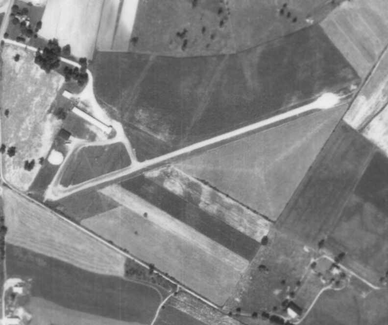
A September 4, 1967 aerial photo depicted the 2nd site of the Bedford Airport
as having a single paved northeast/southwest runway, along with a grass crosswind runway.
A hangar was located on the west side of the field.
The 2nd Bedford Airport apparently closed at some point between 1965-68,
as it was no longer depicted at all on the May 1968 Cleveland Sectional Chart (courtesy of Chris Kennedy)
or the 1973 USGS topo map.
In the early 1970s, the old hangar still stood & you could still make out the grass airstrip.
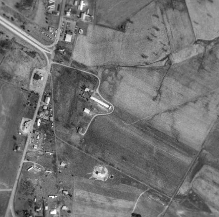
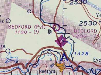
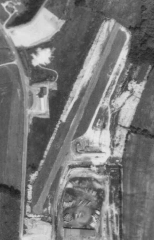
The site of the 2nd Bedford Airport, as seen in the 1993 USGS aerial photo.
The pavement of the former northeast/southwest runway had been completely removed,
with the trace of the runway still barely recognizable, as well as the outline of the crosswind grass runway.
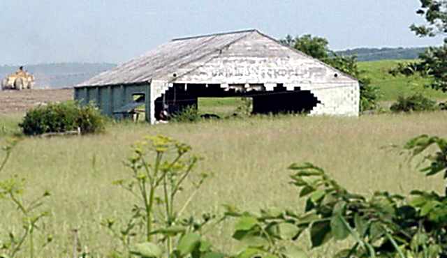
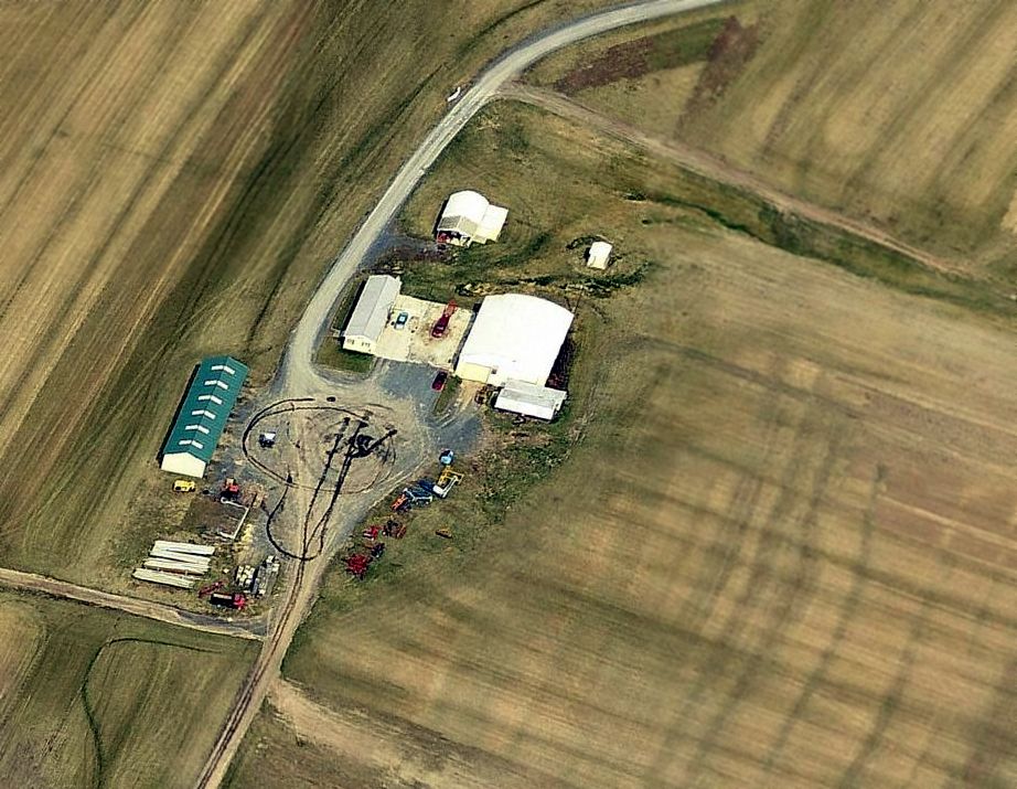
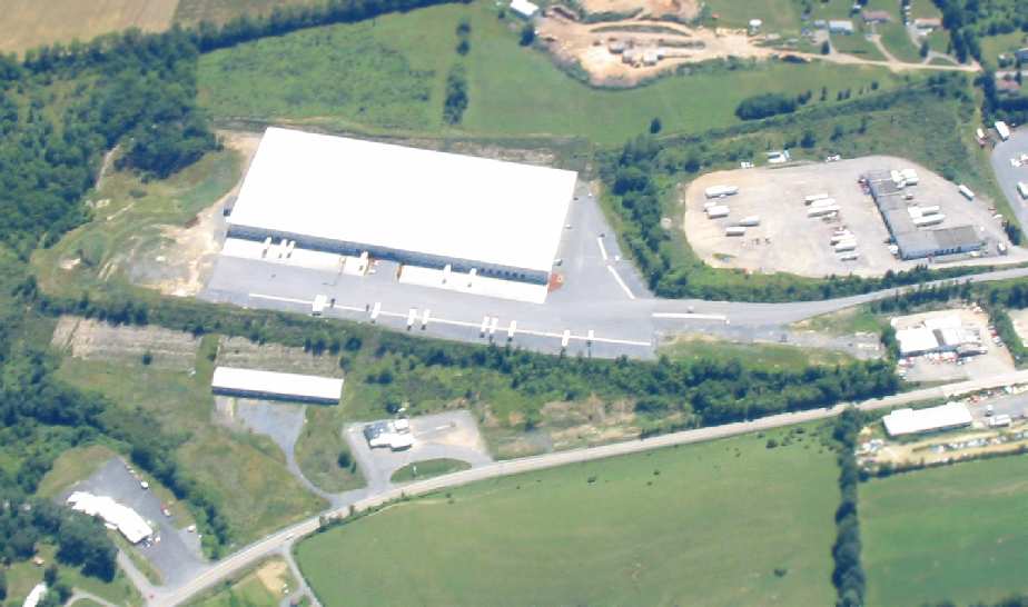
A June 2003 photo “of the former Blair-Bedford Airways hangar” (courtesy of Dave Gurkin).
Dave reported, “You will notice the earth mover on the left border of the picture moving dirt for the Wal-Mart Distribution center.
Sadly, the hangar disappeared shortly after the photo was taken.”
David Gurkin reported in 2004, "Wal-Mart has a large distribution warehouse located adjacent to the Bedford Airport
which is actually located in Cessna, PA.
There are 2 old wooden & cement block hangars still standing (in very poor condition)
but the outline of 'Blair Bedford Airways' is visible on one of them."
Ironically, in 1989 a groundbreaking ceremony was held for the 4th location of yet another Bedford Airport,
which actually now occupies the same property as the 2nd location of the Bedford Airport.
____________________________________________________
Bedford Airport (4G9) (3rd location) / Bedford-Wiedman Airport, Bedford, PA
40.06, -78.51 (Northwest of Hagerstown, MD)
The 3rd location of the Bedford Airport, as depicted on the May 1963 Cleveland Sectional Chart (courtesy of Chris Kennedy).
This airfield was constructed to replace the 2nd Bedford Airport (2 miles to the northwest).
The 3rd Bedford Airport was evidently constructed at some point between 1958-62,
as it was not yet depicted on the 1958 USGS topo map, the January 1958 Cleveland Sectional Chart (courtesy of Chris Kennedy),
or a May 22, 1958 aerial photo.
The earliest reference to the 3rd location of the Bedford Airport which has been located
was in the 1962 AOPA Airport Directory.
It described the Bedford Airport as having a single 2,050' bituminous Runway 3/21,
and listed the operator as Blair-Bedford Airways.
The earliest depiction of the 3rd Bedford Airport which has been located
was on the May 1963 Cleveland Sectional Chart (courtesy of Chris Kennedy).
It described the field as having a single 2,050' bituminous runway.
The 3rd location of Bedford Airport was built next to the Pennsylvania Turnpike,
which made the airport easier to locate from the air.
The landing strip was literally on the side of a mountain.
With only a 2,000' paved runway,
it was known to western Pennsylvania pilots as a challenging airport to fly into or out of.
It had a sign near the southern end of the runway that said "Jump".
According to Erik Wagner, "Bedford was known for the distance to go markers: 1,500', 1,000', 500', Jump!".
The 3rd location of the Bedford Airport was listed in the Aerodromes table
of the May 1965 Cleveland Sectional Chart (according to Chris Kennedy) as "Bedford-Weidman",
with otherwise the same airfield description as on the 1963 chart.
The August 1965 Huntington Sectional Chart (courtesy of Ron Kunse)
depicted Bedford as having a 2,000' paved runway.
The earliest photo which has been located of the 3rd site of the Bedford Airport
was a September 4, 1967 aerial photo.
It depicted Beford as having a single paved northeast/southwest runway,
with a building & 2 light aircraft visible on the east side of the field.
By the time of the May 1968 Cleveland Sectional Chart (courtesy of Chris Kennedy),
the field was listed once again simply as "Bedford".
David Gurkin recalled, "I worked for Frank (Bunny) Grazier
(Graz Company & Bun Air, two of the company names which came after the original Blair Bedford Airways)
flying out of the 2,000' strip operating Cessna 300 & 400 series multi-engine aircraft in the 1960s & 1970s.
We always landed on Runway 21 (uphill) and departed on Runway 3 (downhill).
I remember watching nervous pilots attempting to land at Bedford,
one in particular flying a Beech Baron circling the airport for about 15 minutes,
then landing, locking the brakes & blowing out both main tires!
Frank (Bunny) Grazier, the owner of Blair Bedford airways, Graz Company, Bun Air,
was a former P-61 Black Widow pilot & at one time had the highest amount of flight time of anyone logged in Cessna 310s.
His son Frank now operates Bun Air at the new (HMZ) airport."
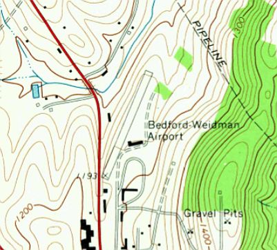
The 1971 USGS topo map depicted “Bedford-Wiedman Airport”
as having a single paved northeast/southwest runway, with one building on the east side of the field.
The August 1976 Cincinnati Sectional Chart (courtesy of Mitchell Hymowitz)
depicted the Bedford Airport as having a single 2,000' paved runway.
In the 1982 AOPA Airport Directory (courtesy of Ed Drury) the operator was listed as Bun Air Corp.
It was labeled as “Bedford Airport” on the 1982 & 1987 USGS topo maps.
In subsequent years the need was expressed to build a larger, more modern airport for the Bedford area
(for what would become the town's 4th distinct airport).
A groundbreaking ceremony was held in 1989 for the new Bedford County Airport (HMZ),
located only a mile north.
Ironically, the locations of the Bedford Airport had come full circle,
as the 4th location of the Bedford Airport was adjacent to the east side of the 2nd location of the Bedford Airport.
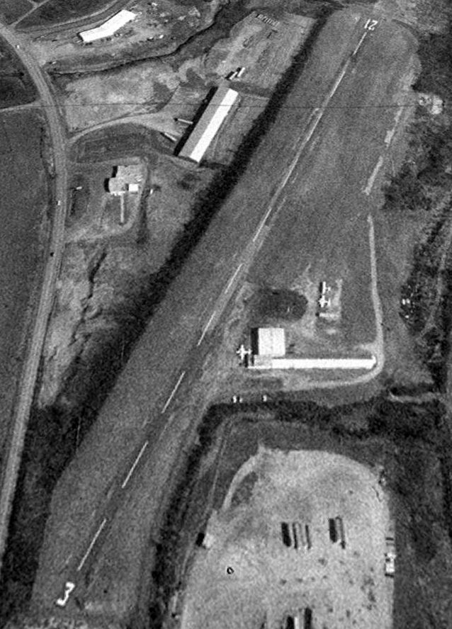
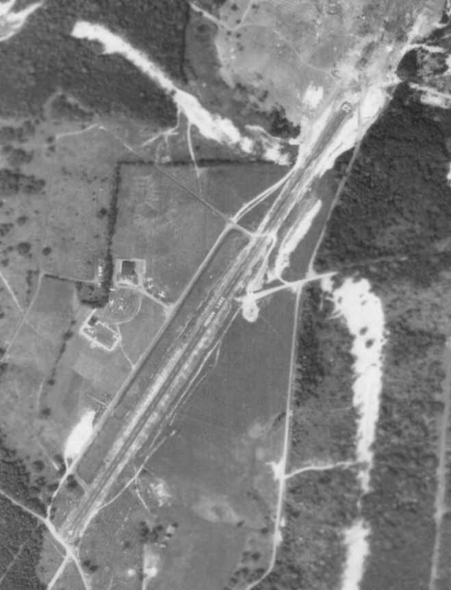
The last photo which has been located showing the 3rd location of the Bedford Airport still in operation
was a 4/7/93 USGS aerial view looking north.
Three light aircraft were visible parked outside on the field.
The new Bedford airport opened for business in 1994,
at which point the 3rd location of the Bedford Airport presumably closed.
The 1995 USGS topo map still depicted the 3rd location of the Bedford Airport.
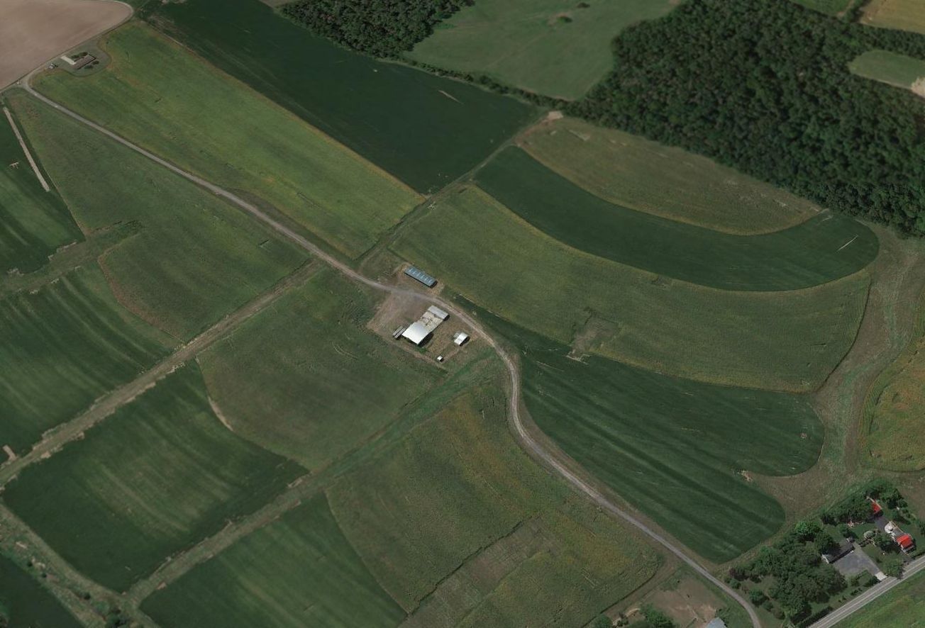
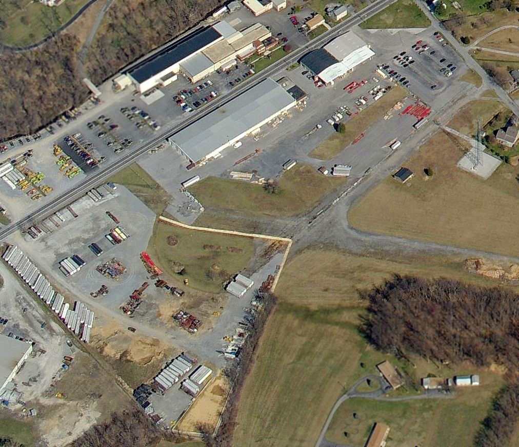
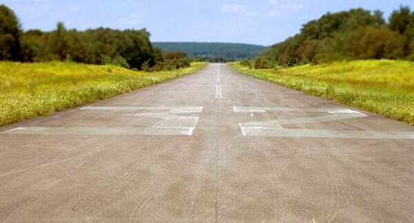
A 2003 aerial view by Paul Freeman, looking east at the former runway of the 3rd location of the Bedford Airport.
The former runway still existed,
and even the runway number "3" was still visible on the south end of the runway (right side of the above photo).
Trucks were parked along the northern end of the runway,
and the area previously occupied by the airport ramp (adjacent to the east side of the runway)
had been covered by a large newly constructed warehouse.
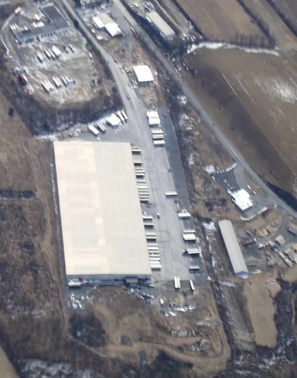
A March 2008 aerial view by Paul Freeman, looking southwest at the former runway of the 3rd location of the Bedford Airport.
The former runway was less recognizable than in previous photos.
The airport site is located on the east side of Route 220,
just northeast of the intersection of the Pennsylvania Turnpike & Interstate 99.
See also: http://www.faa.gov/ats/afss/aooafss/airport2.htm
____________________________________________________
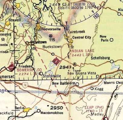
Indian Lake Airport (5G2), Central City, PA
40.05 North / 78.85 West (East of Pittsburgh, PA)
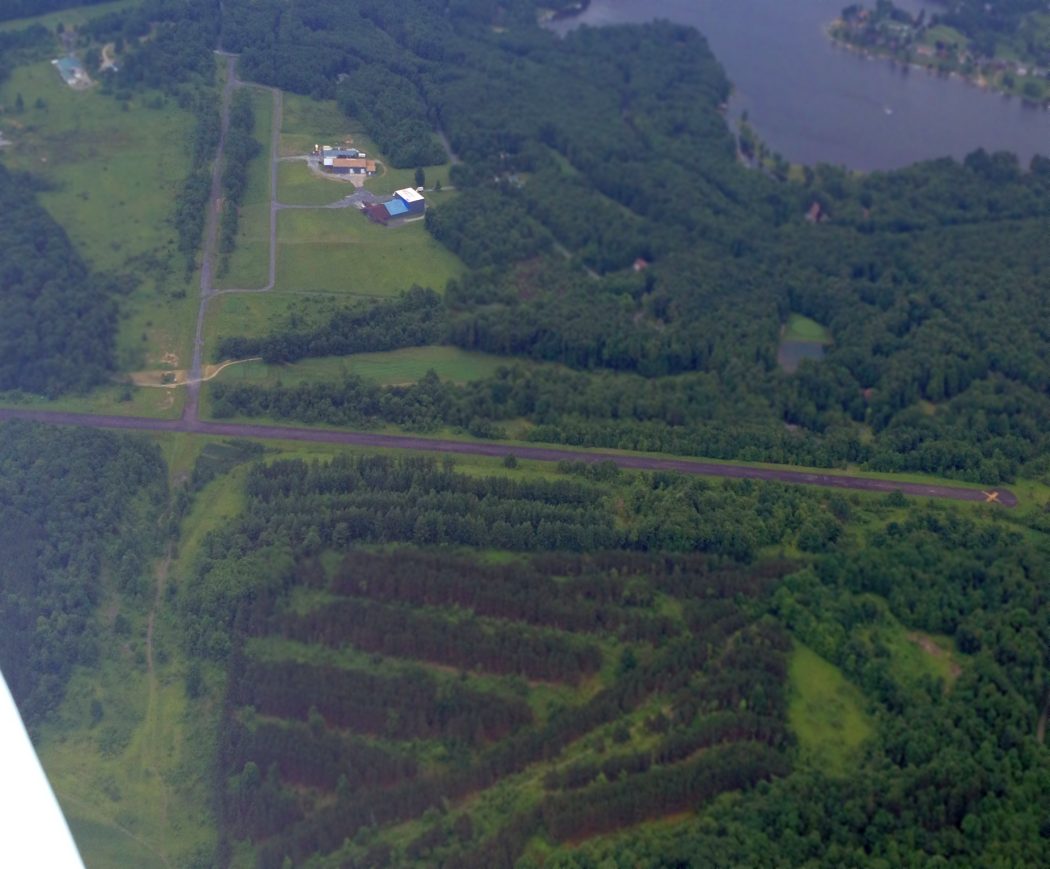
The earliest depiction which has been located of the Indian Lake Airport was a 9/4/67 aerial photo.
Indian Lake was a small resort community, developed by James McIntyre.
McIntyre purchased a 200 plus acre farm in Stonycreek Township in the early 1950s.
He had just sold his aerial mapping business in Pittsburgh
and was looking to start a life in Somerset County.
During the fall of 1956 Hurricane Hazel swept through the area, raising the water level about 20 feet.
McIntyre returned to the task of aerial mapping in 1959, taking pictures for Neilan Engineers.
One afternoon, McIntyre was flying back from taking aerial photos in Altoona
when he passed over a flooded area from the spring thaw.
"I suggested to Frank & Jim (Neilan) the possibility of constructing a lake for recreational use."
A total of 54 different parcels, containing roughly 3,000 acres was purchased around the proposed lake.
Construction on the dam was underway in late 1960 & continued through 1961.
The corporation began to flood the area in 1963.
It would take until after the winter of 1964 for it to be at capacity.
With the lake underway & lots being sold, work to develop a community around Indian Lake began.
"While we were still building the lake... We built a lodge up there. We built the 9-hole golf course."
A ski slope & a Winchester gun club were also built.
The Indian Lake Airport was added in 1966. "I had an airplane..." said McIntyre with a smile.
The earliest depiction which has been located of the Indian Lake Airport was a 9/4/67 aerial photo.
It depicted Indian Lake in its original configuration, with a single paved Runway 4/22,
and at least 6 light aircraft visible parked around a building on the west side of the field.
The earliest aeronautical chart depiction which has been located of the Indian Lake Airport
was on the May 1968 Cleveland Sectional Chart (courtesy of Ron Plante).
It depicted Indian Lake as having a single northeast/southwest paved 3,000' runway.
By 1971, Allegheny Mountain Lakes Inc. was no longer looking to own Indian Lake.
"We sold the whole kit & caboodle to a group from Ohio," said McIntyre.
The lake became the property of the borough.
The 1975 Washington Sectional Chart (courtesy of Ed Drury) showed that depicted Indian Lake Airport
had evidently gained a 2nd (northwest/southeast) paved runway at some point between 1967-75,
with the longest runway depicted as 4,500'.
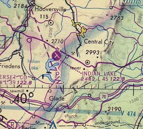
The August 1976 Cincinnati Sectional Chart (courtesy of Mitchell Hymowitz) depicted Indian Lake Airport as having 2 paved runways,
with the longest runway depicted as 4,500'.
The 1982 AOPA Airport Directory (courtesy of Ed Drury)
described Indian Lake Airport as consisting of 2 asphalt runways (13/31: 4,500' & 4/22: 3,000'),
and listed the operator as Indian Lake Airpark.
The March 1993 Washington Sectional Chart (courtesy of Carl Taylor)
depicted Indian Lake as having a single 4,500' paved runway.
The original runway (4/22) had evidently been abandoned at some point between 1982-93.
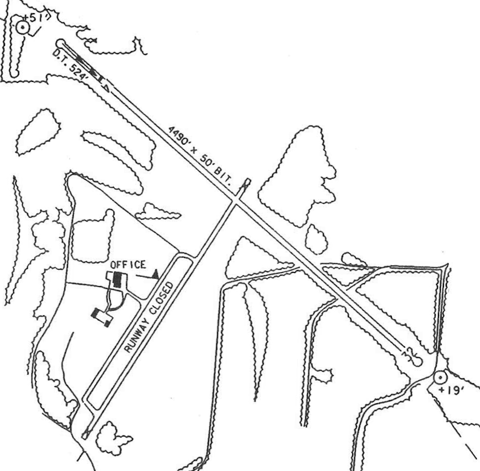
The last airport directory listing which has been located of Indian Lake Airport was in the 1997 PA Airport Directory (courtesy of John Clifford).
It depicted Indian Lake as having a 4,490' bituminous Runway 4/32,
with the original Runway 4/22 still depicted but labeled closed.
The licensee was listed as Dennis Markferding, the manager as Joseph Markferding, and the operator as Indian Lake Airport Inc.
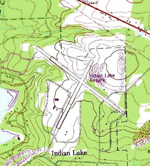
Indian Lake Airpark was depicted on the 1995 USGS topo map
as having 2 paved runways, with 3 small buildings west of the runway intersection.
Indian Lake Airport closed for unknown reasons in 1999.
A 2001 aerial view by Paul Freeman looking southwest at Indian Lake,
showing both paved runways still existed in very good condition, along with a group of small hangars.
A 2001 aerial view by Paul Freeman looking east at the Indian Lake hangars.
In 2002, Indian Lake was advertised for sale as an airfield.
The 2004 USGS aerial photo showed the Indian Lake Airport to remain in excellent condition -
even with markings on Runway 14/32 which seemed to indicate an open runway (no closed-runway “X” symbols).
A circa 2002-2006 photo of a building at Indian Lake Airport.
A circa 2002-2006 photo looking northwest along Runway 32 at Indian Lake Airport.
In 2006, the 60-acre Indian Lake Airport property was still listed for sale, for only $7 million.
A 6/29/14 aerial view by Paul Freeman looking south at Indian Lake,
showing Runway 14/32 remains in very good condition, though marked with closed-runway “X” symbols.
____________________________________________________
Since this site was first put on the web in 1999, its popularity has grown tremendously.
That has caused it to often exceed bandwidth limitations
set by the company which I pay to host it on the web.
If the total quantity of material on this site is to continue to grow,
it will require ever-increasing funding to pay its expenses.
Therefore, I request financial contributions from site visitors,
to help defray the increasing costs of the site
and ensure that it continues to be available & to grow.
What would you pay for a good aviation magazine, or a good aviation book?
Please consider a donation of an equivalent amount, at the least.
This site is not supported by commercial advertising –
it is purely supported by donations.
If you enjoy the site, and would like to make a financial contribution,
you
may use a credit card via
![]() ,
using one of 2 methods:
,
using one of 2 methods:
To make a one-time donation of an amount of your choice:
Or you can sign up for a $10 monthly subscription to help support the site on an ongoing basis:
Or if you prefer to contact me directly concerning a contribution (for a mailing address to send a check),
please contact me at: paulandterryfreeman@gmail.com
If you enjoy this web site, please support it with a financial contribution.
please contact me at: paulandterryfreeman@gmail.com
If you enjoy this web site, please support it with a financial contribution.
____________________________________________________
This site covers airfields in all 50 states.