Abandoned & Little-Known Airfields:
Ohio: Northern Cleveland area
© 2002, © 2016 by Paul Freeman. Revised 9/16/16.
This site covers airfields in all 50 states: Click here for the site's main menu.
____________________________________________________
Please consider a financial contribution to support the continued growth & operation of this site.
Avon Airport (revised 1/21/16) - Casement Airport (revised 3/6/16) - Chardon Airfield (revised 3/6/15)
Martin Factory Airfield / Great Lakes Aircraft Company Airfield (revised 5/2/15)
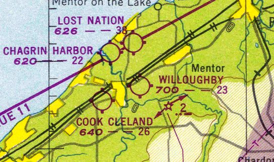
Willoughby Field / Euclid Avenue Airport / Cook Cleland Airport (revised 9/16/16) - Willoughby Municipal Airport (added 2/28/15)
____________________________________________________
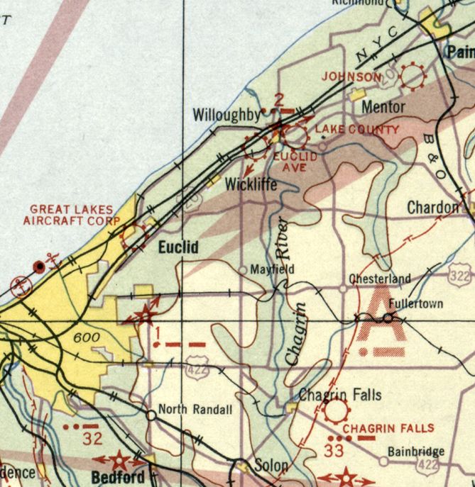
41.43, -81.97 (West of Cleveland, OH)
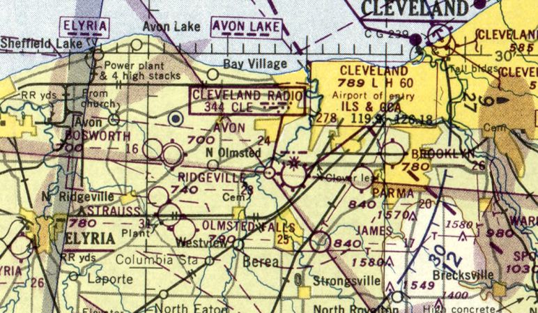
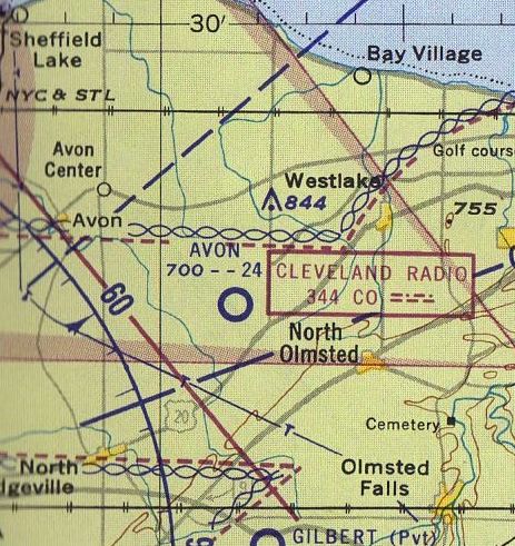
Avon Airport, as depicted on the November 1950 Cleveland Sectional Chart.
The date of establishment of this small general aviation airport on the west side of Cleveland has not been determined.
The earliest depiction which has been located of Avon Airport was on the November 1950 Cleveland Sectional Chart,
which depicted Avon Airport as having a 2,400' unpaved runway.
The earliest photo which has been located of Avon Airport was a 1951 aerial view (courtesy of Mike Kmetz).
It depicted Avon Airport as having 3 unpaved runways.
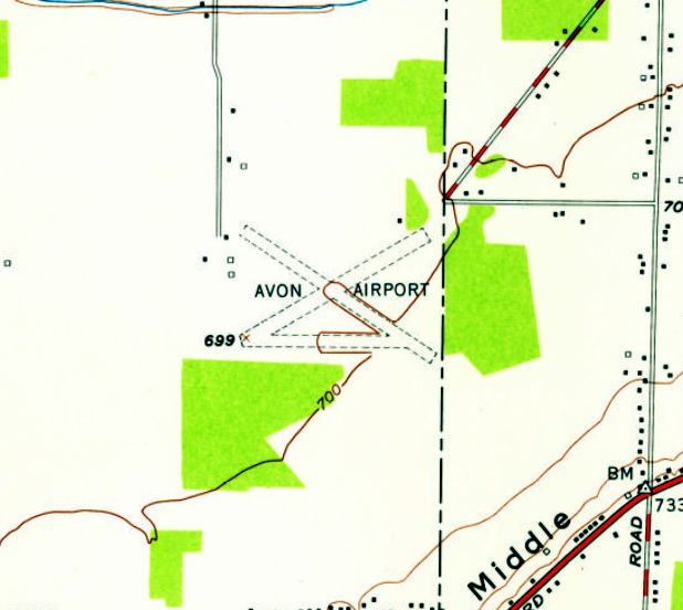
The earliest topo map depiction which has been located of Avon Airport is the 1953 USGS topo map.
It depicted Avon Airport as having 3 unpaved runways, with a few small buildings on the northwest side.
A circa 1954-59 aerial view looking south at Avon Airport (courtesy of Greg Hamilton),
showed several brightly-colored light planes parked near some small buildings on the northwest side.
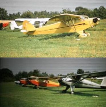
Two circa 1954-59 photos (courtesy of Greg Hamilton) of Greg's father's Piper Cub & other aircraft at Avon Airport.
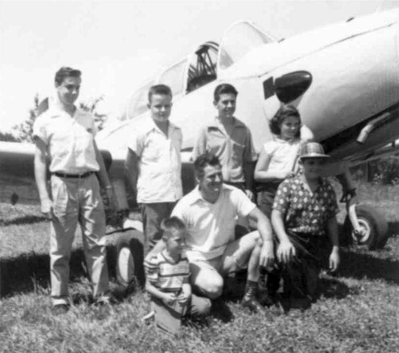
An August 1957 photo (courtesy of Mike Kmetz) of himself (far left) & others in front of a PT-26 flown by his friend’s uncle at an event at Avon Airport.
Mike Kmetz recalled, “In August 1957 I attended a competitive event for pilots there (spot landing; bomb drop).”
Mike Kmetz recalled, “Avon Airport... A friend gave me my first ride in a light plane there in his father’s Piper Tri-Pacer in 1959.
This was one of those relaxed airports where pilots socialized with their families.
I recall going west on Schwartz Road from Bradley, then turning left onto a long gravel road to the airport.
The grass runway was east/west.
There was an old farm house & hangars at the west end right by the gravel road.”
The last aeronautical chart depiction which has been located of Avon Airport
was on the 1960 Cleveland Local Aeronautical Chart.
It depicted Avon as having a 2,400' unpaved runway.
According to Greg Hamilton (whose father kept his plane at Avon),
“Avon Airport... closed around 1961 for development.”
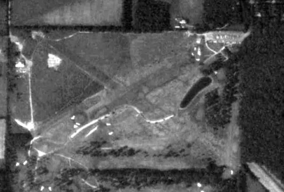
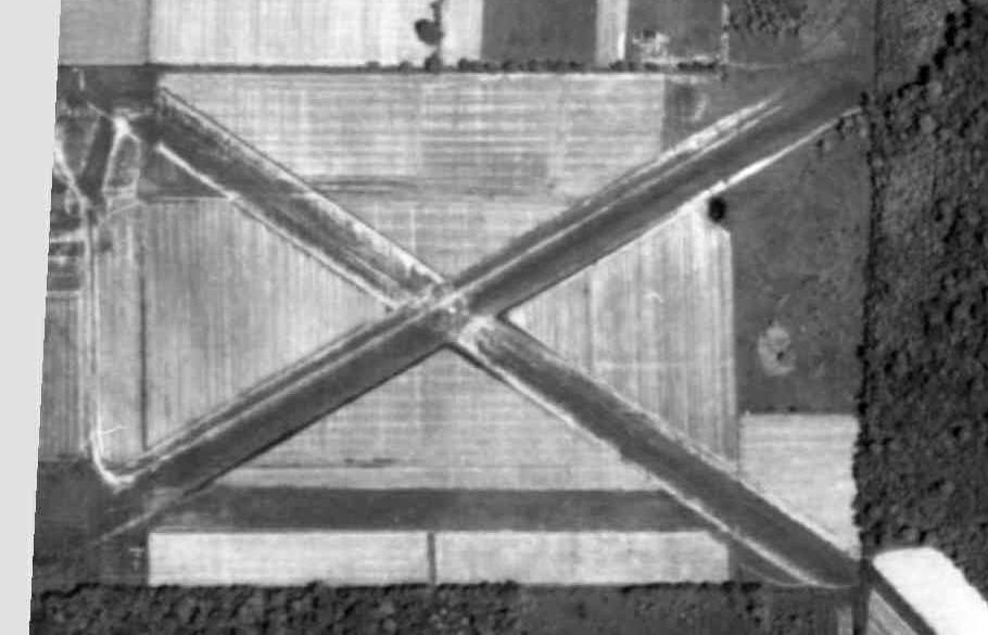
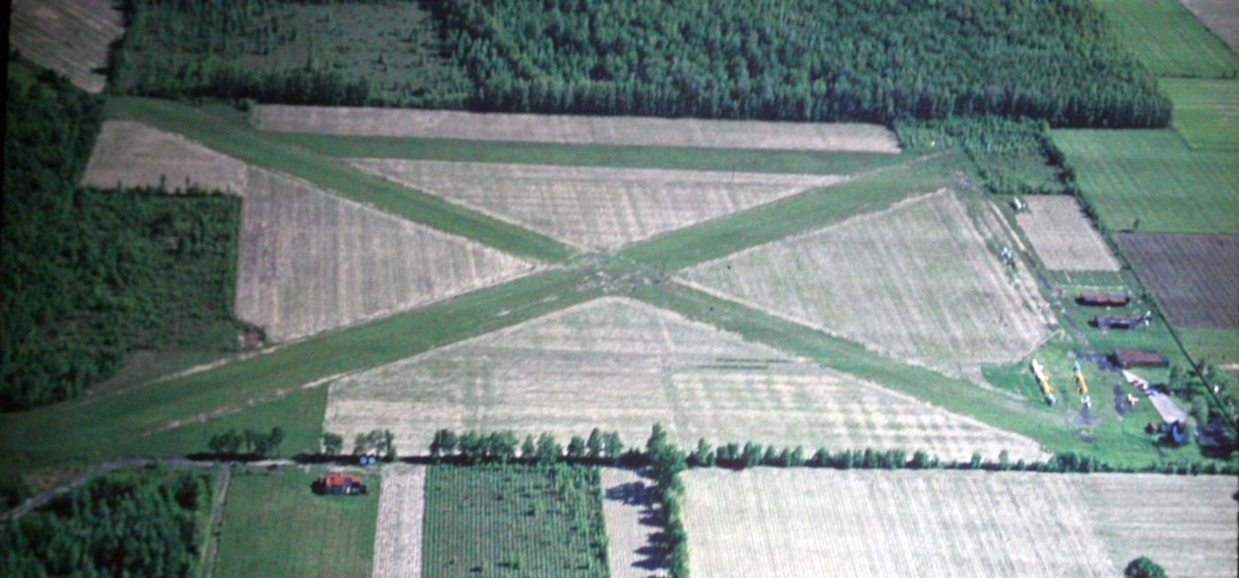
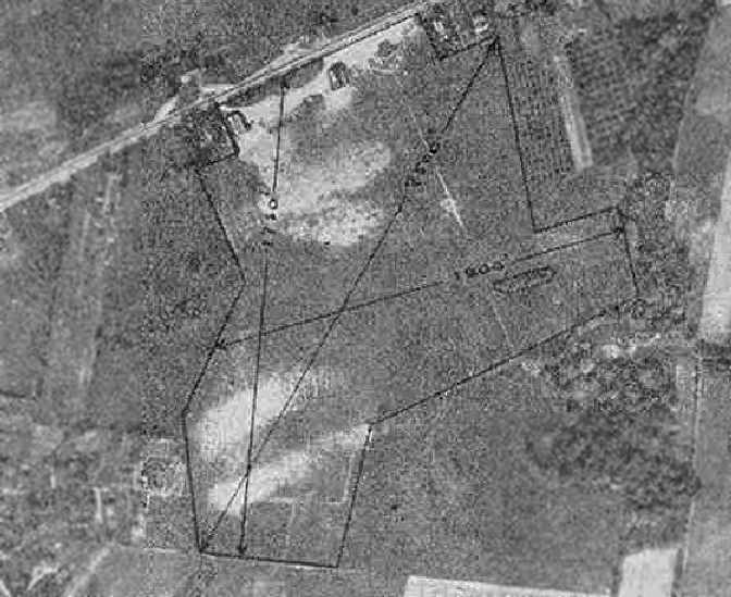
A 1979 aerial view (courtesy of Mike Kmetz) showed the X-shape remaining of Avon Airport's runways, but the property may have already been under redevelopment into a golf course.
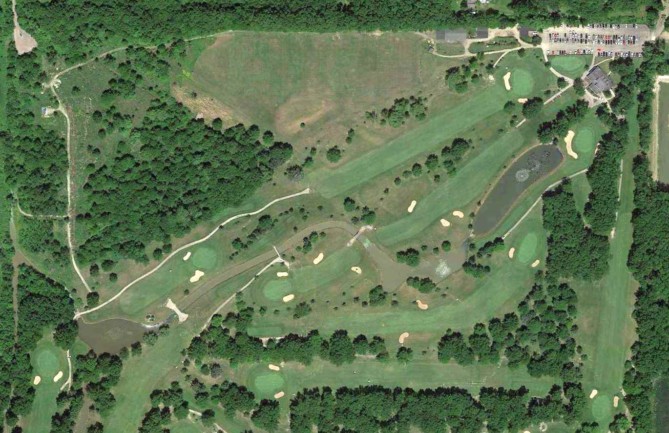
A 2014 aerial view showed the golf course covering the site of Avon Airport, but even after more than 50 years the X-shape of the former runways was still recognizable.
As of 2015, street maps label the site of Avon Airport as Hillard Lakes Golf Club.
The site of Avon Airport is located at the western terminus of Lincoln Road.
Thanks to Mike Kmetz for pointing out this airfield.
___________________________________________________
Willoughby Municipal Airport, Willoughby, OH
41.64 North / 81.38 West (Northeast of Cleveland, OH)
An aerial view of Willoughby Municipal Airport
from The Airport Directory Company's 1938 Airports Directory (courtesy of Chris Kennedy).
This small airport on the northeast side of Cleveland was evidently established at some point between 1929-38,
as it was not yet depicted on the 1929 Airway Map (courtesy of Chris Kennedy).
The earliest reference which has been located to the field
The earliest depiction of Willoughby Field which has been located
was an aerial photo in The Airport Directory Company's 1938 Airports Directory (courtesy of Chris Kennedy).
It described Willoughby Municipal Airport as having 3 sod runways, with the longest being the 2,500' northeast/southwest strip.
A May 1939 photo (courtesy of Chuck Slusarczyk of OPShots.net).
Chuck observed the photo is “of my grandfather (Ageton 'Aggie' Sobbota) as he waves from his beloved Travelair in Willoughby.
My Grandpa was a bit of a barnstormer back in the day.”
The earliest aeronautical chart depiction which has been located of Willoughby Airport
was on the March 1940 Cleveland Sectional Chart (courtesy of Richard Finley).
The last aeronautical chart depiction which has been located of Willoughby Airport
was on the January 1949 Cleveland Sectional Chart (courtesy of Chris Kennedy).
Willoughby Airport was evidently closed (for reasons unknown) at some point between 1949-53,
as it was no longer depicted on the June 1953 Cleveland Local Aeronautical Chart (courtesy of Chris Kennedy).
A 2014 aerial view shows no trace remaining of Willoughby Airport.
The site of Willoughby Airport is located roughly near the intersection of Route 20 & Route 306.
____________________________________________________
Martin Factory Airfield / Great Lakes Aircraft Company Airfield, Cleveland, OH
41.56 North / 81.56 West (Northeast of Downtown Cleveland, OH)
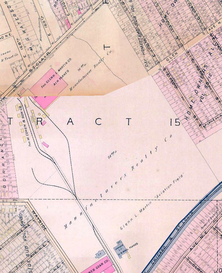
A circa 1920-22 map of the “Glen L. Martin Aviation Field”.
According to Tom Beamer, “In January 1918 Glenn L. Martin received a contract for a twin-engine biplane bomber.
Martin had financial backers in Cleveland, and built a 61,000 square foot plant with adjoining flight test field.
Lawrence Bell was the factory manager & was in charge of supervising plant construction.
Donald Douglas was responsible for design of the bomber.
The first plane (GMB/MB-1) was completed by September of 1918.”
The earliest depiction which has been located of “Glenn L. Martin Aviation Field” was on a 1920-22 map.
It depicted a factory building on the northwest corner of the field,
and an airmail hangar on the southern corner.
The earliest photo which has been located of “Glenn L. Martin Field”
was an undated aerial view from the 1921 Eytinge's Flying Guide (courtesy of Alex Sheppard).
It depicted the “Aerial Mail Hangar & Cinder Runway”.
The directory described the “Glen l. Martin Company aeroplane factory & field” as “used by U.S. Aerial Mail”,
as described the field as measuring 3,300' x 1,500'.
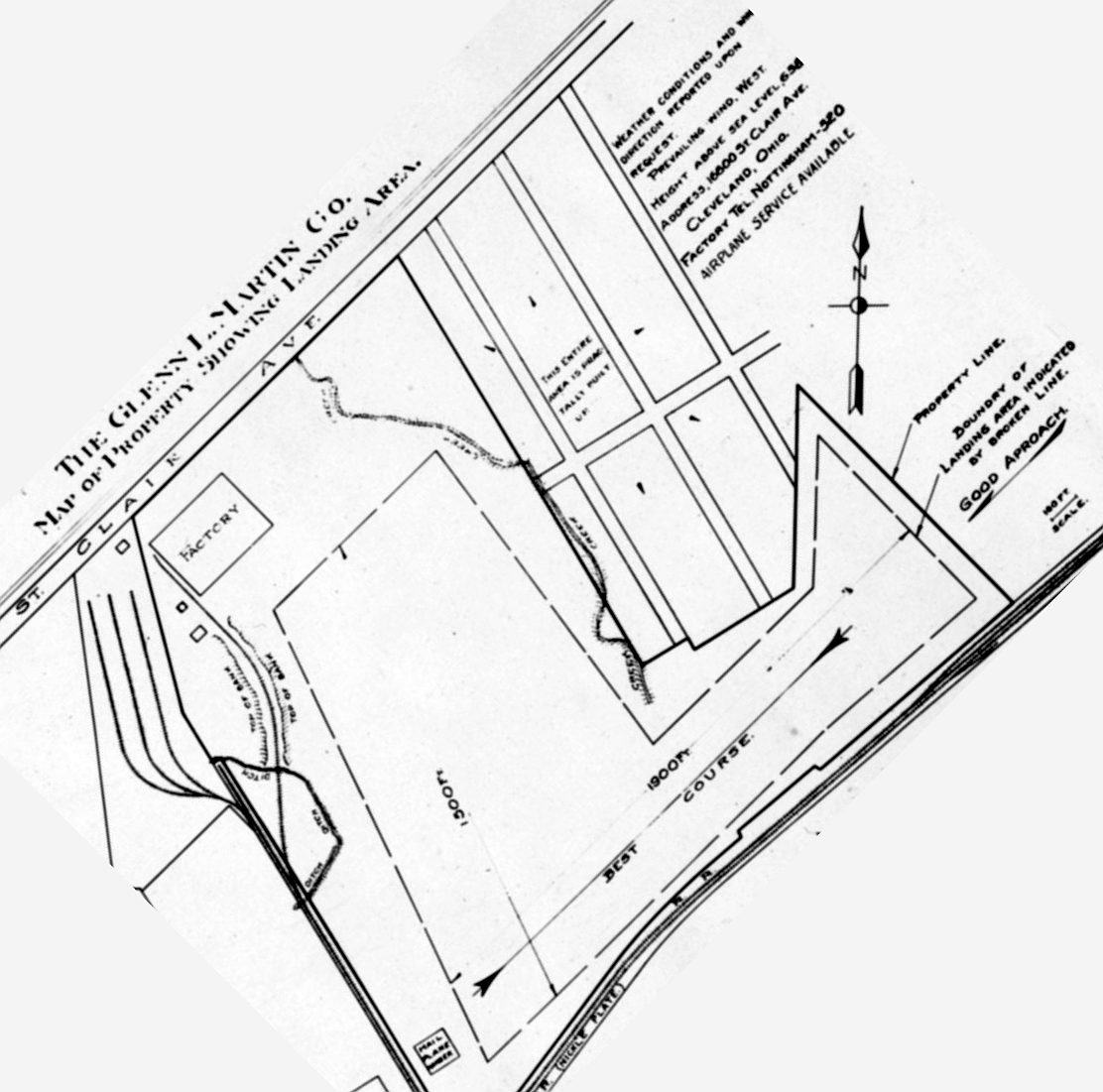
A circa 1922 Glen L. Martin Company map (courtesy of Tom Hietzman)
depicted the Martin factory airfield as having 2 runways: 1,900' northeast/southwest & 1,500' northwest/southeast.
According to Tom Beamer, “By 1928 Martin realized that the future was in all metal aircraft & sold the Cleveland plant to Detroit Aircraft
so he could build a new plant optimized for metal construction in a warmer location (Baltimore, MD)
that was better suited for flight testing flying boats year-round.
The Cleveland subsidiary of Detroit Aircraft was named Great Lakes Aircraft
and the first product was the TG-1 torpedo bomber biplane.
The TG-1 was a re-designation of the last aircraft Martin built for the Navy in Cleveland, the T4M-1.
In 1929 Great Lakes produced the famous Sport Trainer - the plane that established their reputation.”
The earliest aeronautical chart depiction which has been located of the Martin Factory Airfield
was on the 1929 Airway Map (courtesy of Chris Kennedy).
The January 1936 Civil Aeronautics Administration Airport Directory (courtesy of Tom Beamer)
described the Great Lakes Aircraft Corporation Field as a commercial field.
It was said to be an L-shaped field, with 2 runways: 1,900' northeast/southwest & 1,500' northwest/southeast.
According to Tom Beamer, “Unfortunately the stock market crash & depression spelled an early end to Great Lakes.
By 1936 the doors were closed, and the plant up for sale in 1937.”
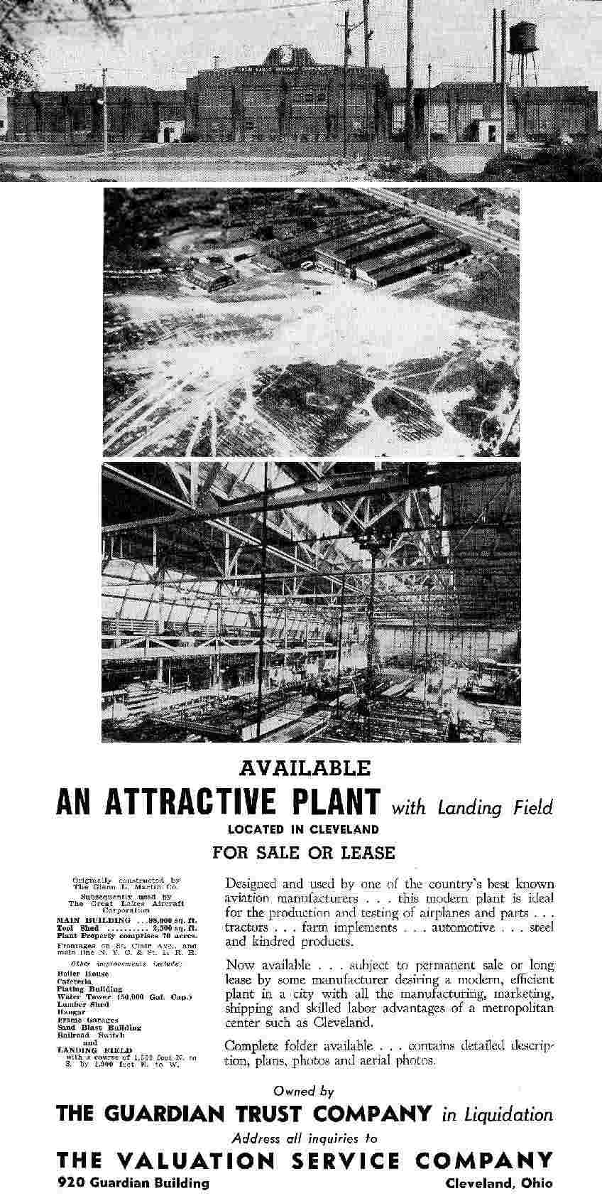
A 1937 advertisement for the property (courtesy of Tom Beamer)
described the site as totaling 70 acres, including 100,000 square feet of buildings.
An undated aerial photo depicted at least one biplane adjacent to the factory, with an open grass landing area.
The Great Lakes Airfield was no longer listed at all
in The Airport Directory Company's 1937 Airports Directory (according to Tom Beamer),
nor was it depicted on 1939 USGS topo map nor on the April 1943 Cleveland Sectional Chart (courtesy of Barnard Kemter).
A 1952 aerial photo showed that another industrial building
had been constructed at some point on the site of the airfield,
but the Martin factory building remained standing.
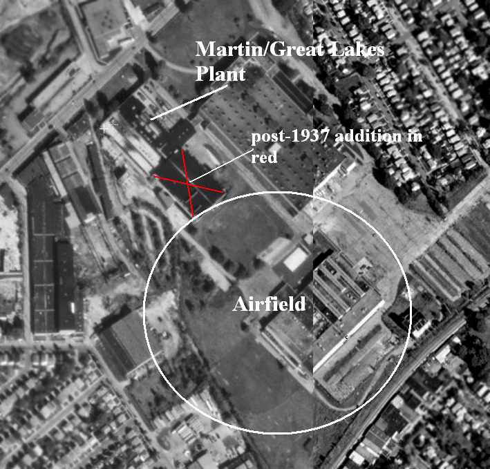
The 2000 USGS aerial photo was annotated by Tom Beamer to show the former Martin factory building & the location of its airfield.
A circa 2006 aerial photo looking east at the former Martin aircraft factory building.
The site of the Martin Factory Airfield is located south of the intersection of St. Clair Avenue & East 168th Street.
____________________________________________________
Willoughby Field / Euclid Avenue Airport / Cook Cleland Airport, Willoughby, OH
41.63, -81.43 (Northeast of Cleveland, OH)
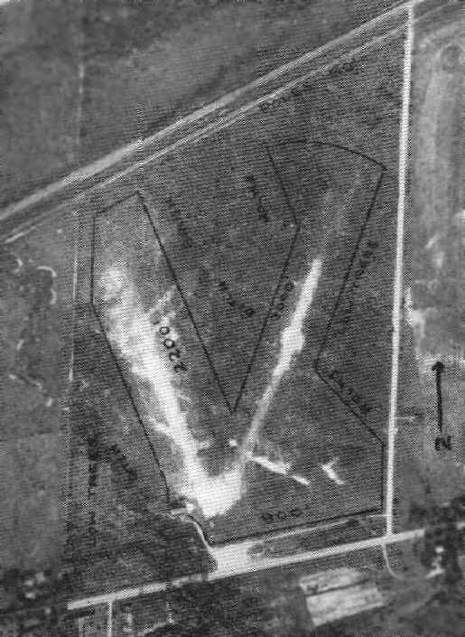
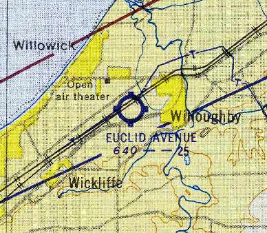
Euclid Avenue Airport, as depicted on the December 1932 Cleveland Sectional Chart.
This small airport on the northeast side of Cleveland was evidently established at some point between 1929-32,
as it was not yet depicted on the 1929 Airway Map (courtesy of Chris Kennedy).
The earliest dated depiction which been located of Euclid Avenue Airport was on the December 1932 Cleveland Sectional Chart.
It depicted Euclid Avenue as a commercial/municipal airport.
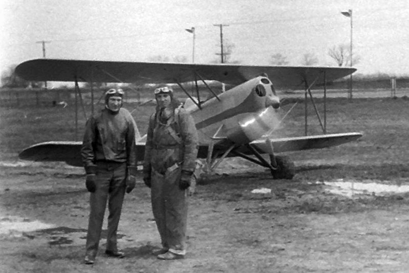
A circa early 1930s photo (courtesy of Kyle Smith) of 2 pilots (one possibly Lester Dethloff) in front of a biplane (model unidentified) at Euclid Avenue Airport.
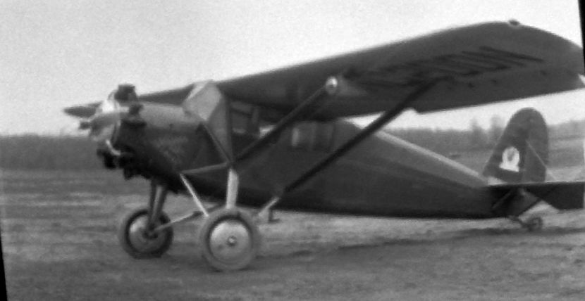
A circa early 1930s photo (courtesy of Kyle Smith) of a high-wing monoplane (model unidentified) at Euclid Avenue Airport.
The Airport Directory Company's 1933 Airports Directory (courtesy of Chris Kennedy)
described “Willoughby Field” as a commercial airport, located 1 mile west of Willoughby.
The field was said to consist of a 100-acre rectangular sod field, on which were 2 runways:
2,300' northeast/southwest & 2,000' northwest/southeast.
The Commerce Department's 1934 Airport Directory (courtesy of Chris Kennedy)
described Euclid Avenue Airport as consisting of a rectangular sod field, on which were 3 runways,
with the longest being the 2,300' northeast/southwest strip.
A hangar was said to have “Euclid Avenue Airport” painted on the roof.
The earliest dated photo which has been located of Euclid Avenue Airport
was an undated aerial view in The Airport Directory Company's 1937 Airports Directory (courtesy of Bob Rambo).
It described Euclid Avenue as a commercial airport, consisting of a rectangular sod field.
The field was said to have 3 runways, with the longest being the 3,000' north-northeast/south-southwest strip.
A single hangar was depicted on the southwest side of the field,
which was said to have "Euclid Avenue Air Service" on the roof.
Euclid Avenue was depicted as a commercial airport
on the April 1943 Cleveland Sectional Chart (courtesy of Barnard Kemter).
A 10/3/43 aerial view looking northwest at Euclid Avenue Airport from the 1945 AAF Airfield Directory (courtesy of Scott Murdock)
depicted the field as an open grass area.
The April 1944 US Army/Navy Directory of Airfields (courtesy of Ken Mercer)
described the Euclid Avenue Airport as having a 2,300' unpaved runway.
The 1945 AAF Airfield Directory (courtesy of Scott Murdock) described Euclid Avenue Airport
as a 90 acre rectangular property within which were 3 sod runways, with the longest being the 2,600' northeast/southwest strip.
The field was said to have a single 80' x 60' brick hangar,
and to be privately owned & operated.
The Haire Publishing Company's 1945 Airport Directory (courtesy of Chris Kennedy)
described Euclid Avenue as a “class 2” airport, owned by A. T. Knudson, and operated & managed by George Latimer.
The field was said to have 3 sod runways,
with the longest being a 2,600' northeast/southwest strip.
It was also said to have an 80' x 60' hangar & an office.
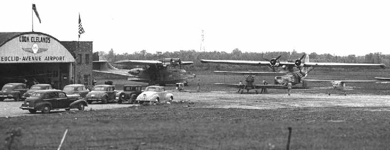
After WW2, Cleveland native Cook Cleland returned from a career as a Navy combat pilot & test pilot,
and he acquired the small airport, which he renamed "Cook Cleland's Euclid Avenue Airport".
He was joined by Dick Becker, who flew PBY’s & PBM’s in the South Pacific as a Navy enlisted pilot.
As a fixed-base operator, he offered flying lessons, banner towing and air charters.
Wanting to expand his air charter service, Cook purchased 3 surplus PBY Catalina Flying Boats;
he sold one at the point of purchase & with Becker’s help he brought the 2 into Euclid Road airport -
quite to bring such a large amphibian into such a small grass runway.
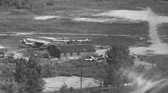
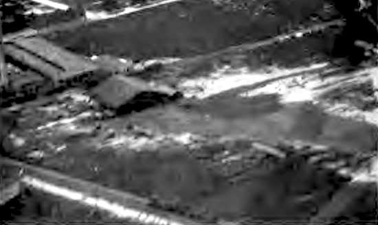
A 1940s aerial view by Bud Ricketts of Cook Cleland's Airport, taken on approach to the north runway.
The 2 PBY Catalinas are visible behind the hangar, and an FG-1 Corsair is parked in front of the hangar.
To be certified for commercial use, the FAA required the following modifications to the Catalinas:
aluminum firewalls had to be replaced with stainless steel, fabric on 2/3 of the wing had to be replaced with metal,
and controls mounted in the pylon had to be moved to the cockpit.
When these modifications were completed, a second PBY was sold.
Work to convert the final plane for the new service which was to be called "Cook Cleland’s Catalina Airways",
and designed to carry sportsmen to Kodiak Alaska for hunting and fishing trips began in earnest.
The rear blister turrets were removed & covered over.
The interior was modified, but not elaborate;
the flying boat was completely painted, cream on top with a deep green on the bottom separated by a metallic bronze feature stripe.
Charlie Miller recalled, “I used to haunt Cook Cleland's Airport after WWII, as it was within range of my Whizzer motor bike.
I got to go through the PBY closest to the hangar.
I learned the difference between 'Port' & 'Starbord' when sitting in the engineer's seat, in the pylon.
They were penciled on either side of the bulkhead. I think the controls/instruments were still there.
Original ads on Cleveland radio were for Canadian fishing trips to otherwise inaccessible lakes north of Cleveland.
One of the Waco bipes was parked in front of the hangar,
and pilot bragged he could take the black Waco off on the square patch of blacktop in front of the hangar.
About 200' I think. He succeeded, though pretty wobbly.”
Charlie continued, “I saw the Corsairs. With the panels off, that engine looked like about 40 rows of radials, stacked!!!
They said he flew it off the line at Akron!
Lot of interesting planes there. I had a chance to buy an AT-6 for $200.
When I sat in it, it seemed HUGE, too big for me.”
A 1940s photo by Bud Ricketts of the 2 PBY Calalinas shortly after they arrived.
Note the hi-tension towers in the background at the North end of the field.
A 1940s photo by Bud Ricketts of one of Cook's 2 banner-towing Wacos, with one of the modified PBYs & the hangar in the background.
In 1946 Cook entered the Cleveland National Air Races,
with the help of some funding from Thompson Products employees with whom he had worked.
His dream was winning the Thompson Trophy Race.
Cook purchased one of the first surplus Corsairs; a FG-1D built by Goodyear in Akron, OH.
He entered ex-Navy Corsairs in all 4 post-war races, realizing his dream twice.
About the time the PBY was finished, the FAA set the gross weight at 27,000 lbs.,
while the military normally flew them at 33,000 lbs.
This weight restriction would allow for only 2 pilots & fuel for a non-stop trip to Alaska.
Cook, now back on active duty, decided to ask Becker to sell the PBY.
Soon after advertising the PBY for sale, a representative from an air charter service in Trinidad arrived,
looking for a replacement of a PBY that was lost in a recent hurricane.
The purchase was completed & the ferry pilot made a fuel stop in Cuba.
On takeoff, someone forgot to secure the tunnel hatch
and once on the step the hull began to fill with water & the craft sank in deep water.
A still from a 1947 movie showing a Cessna T-50 & at least one other aircraft at Cook Cleleland's Euclid Avenue Airport (courtesy of Marc Obenshain).
The field was labeled “Cook Cleland” on the January 1949 Cleveland Sectional Chart (courtesy of Chris Kennedy).
Keith Alves recalled, “I was raised next to Cook Cleland's Euclid Ave Airport.
Winning the 1949 Thompson Trophy Race was one of the high points in Cook Cleland's aviation career.
During this time the Euclid Avenue Airport was very busy.
Lot's of folks were there looking, riding, etc.
And don't forget, the GI bill was making business.”
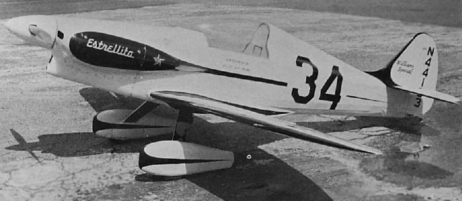
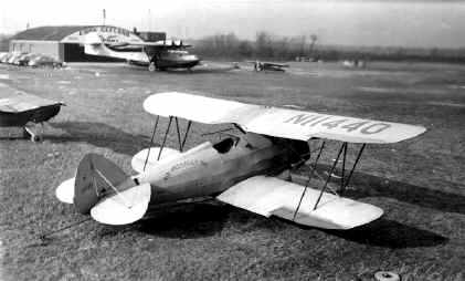
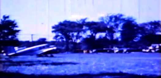
An undated photo (courtesy of Keith Alves) of the Estrellita racer, which crashed at Cook Cleland Airport.
Keith Alves recalled, “Since the 1950 air races were relocated to Detroit,
Cook decided to have an air show at Euclid Avenue Airport.
It was held on Labor Day weekend.
This event was marred by the crash of a racer named 'Estrellita', flown by its new owner Chester Black.
The aircraft was making a high speed pass from East to West when it lost a wing (right over my head).
The aircraft snapped into the ground in front of the spectators.”
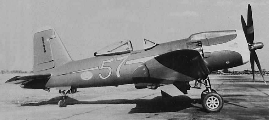
An undated photo (courtesy of Keith Alves) of the Goodyear F2G-1 Corsair racer #57.
According to Keith, “The last day this aircraft flew was at Euclid Ave Airport that weekend in 1950.
The aircraft was left behind at the airport when Cook was recalled.
It sat there long after the airport was gone.
Now [2006] the same aircraft is owned & operated by Bob Odegaard, Kindred, ND.”
In February 1951, Cook Cleland returned to active duty as commanding officer of carrier-based Fighting Squadron 653
and flew the Chance-Vought F4U Corsair in 67 combat missions over North Korea.
The last photo which has been located of the Euclid Avenue Airport was a 4/1/52 USGS aerial view.
It depicted a single building at the southwest side of the field, along with 6 light aircraft.
Keith Alves recalled, “The postwar general aviation 'bust' was starting to affect everyone in the business,
so things started to slow down.
Cook gave up his lease.
The owners of the field released the airport to Frank Zanzo, who had previously operated the Willoughby Airport.
The field closed in the latter part of 1952
and the land along Bidler Road (the east boundary road) was sold to small industry type shops.”
Even though Euclid Avenue Airport was closed in 1952,
it continued to be depicted on aeronautical charts for at least 2 more years.
It was depicted as “Euclid Avenue” Airport
on the June 1953 Cleveland Local Aeronautical Chart (courtesy of Chris Kennedy).
The last chart depiction which has been located of the Euclid Avenue Airport as an active airfield
was on the January 1954 Cleveland Local Aeronautical Chart (courtesy of Chris Kennedy).
It depicted the field as having a 2,500' unpaved runway.
According to Keith Alves (retired FAA controller / Airspace Specialist from the Cleveland area),
“The reason the airport was charted years after it closed was not uncommon in those days.
There was no notification made to the chart-makers.
If there had been a published approach into the airport the closure would have been listed right away.”
The Euclid Avenue Airport was no longer depicted at all
on the January 1955 Cleveland Sectional Chart (courtesy of Chris Kennedy) nor on the 1955 USGS topo map.
A 1962 aerial view showed that a building had been constructed over the north side of the airfield,
but the hangar remained standing on the southwest corner of the property.
A 1970 aerial view showed that multiple buildings had been constructed over the site of the airfield,
but the hangar remained standing on the southwest corner of the property.
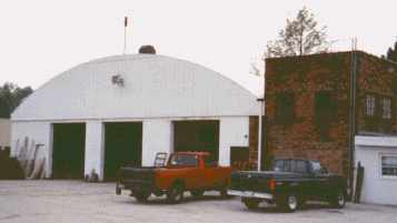
An undated (circa 1990s?) photo by Bob Roskuski of the Euclid Avenue hangar.
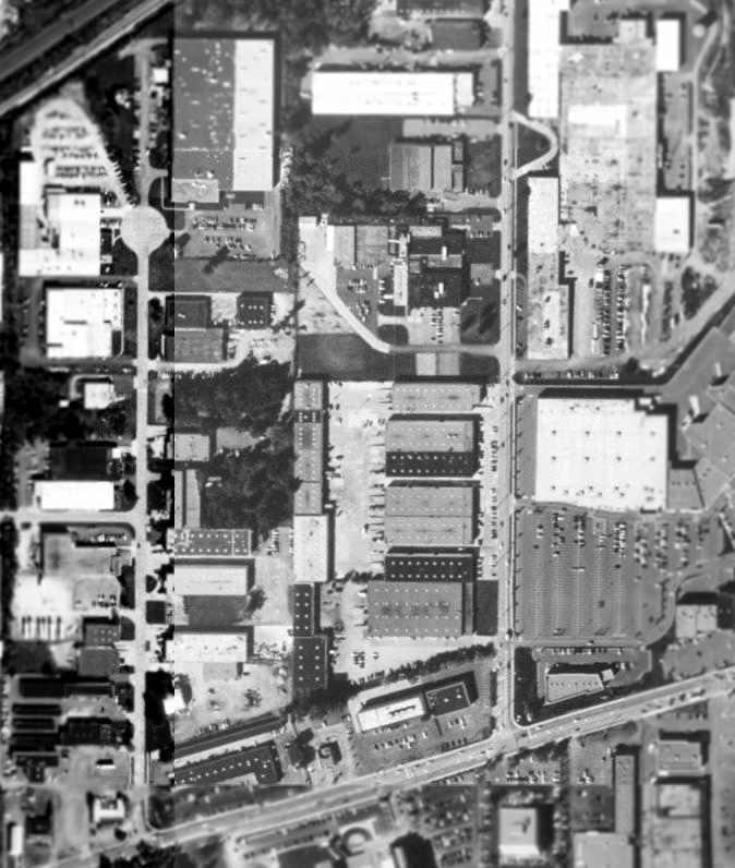
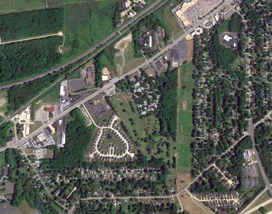
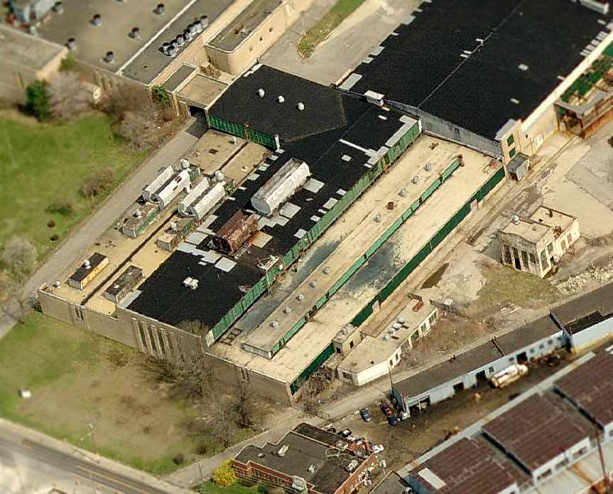
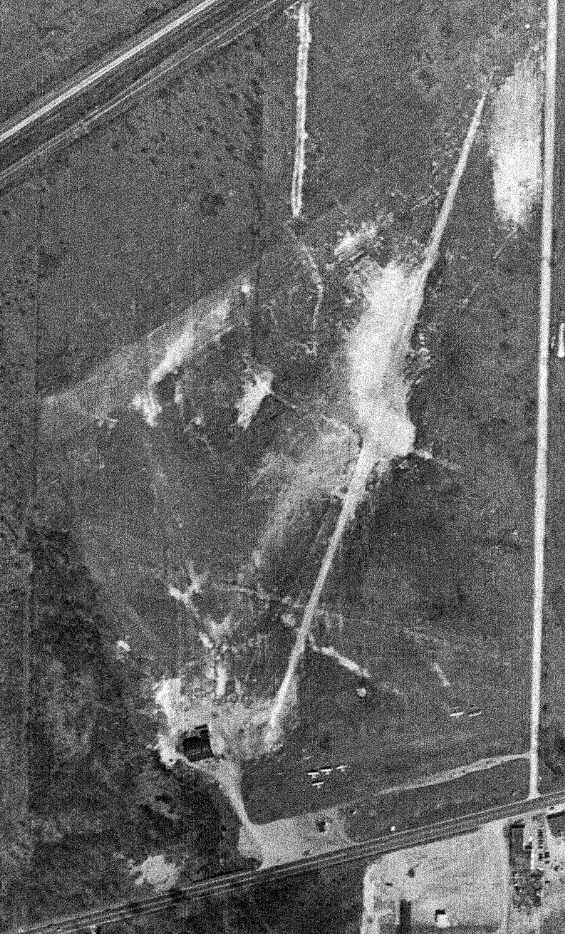
The 2000 USGS aerial photo shows that the majority of the site of the Euclid Avenue Airport has been extensively redeveloped.
The sole remaining trace – the hangar – sits at the bottom-left of the photo.
A circa 2001-2005 aerial view looking west shows that the former hangar
still remains standing at the site of the Euclid Avenue Airport after more than 60 years.
The site of the Euclid Avenue Airport is located northeast Euclid Avenue & 355th Street.
____________________________________________________
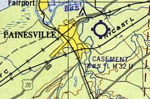
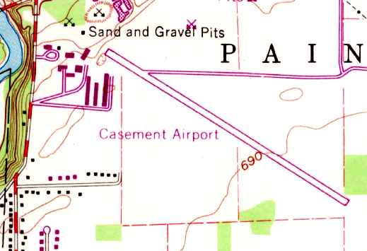
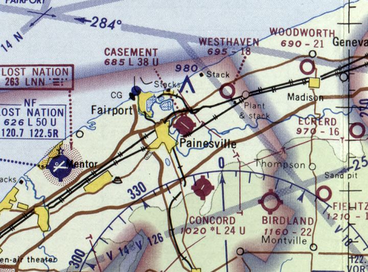
Casement Airport (PVZ), Painesville, OH
41.73, -81.22 (Northeast of Cleveland, OH)
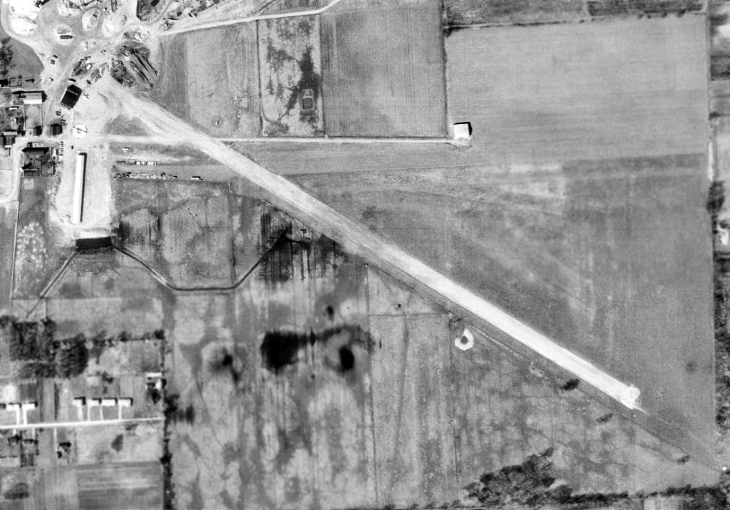
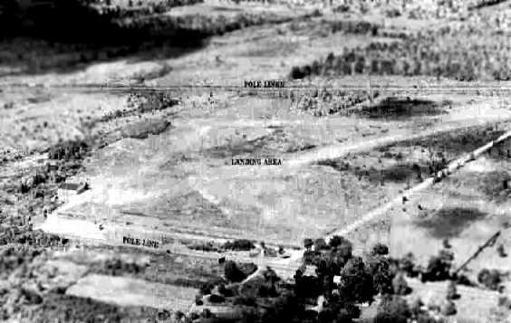
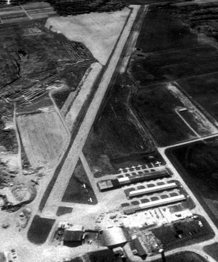
Casement Airport, as depicted on a 4/8/62 USGS aerial photo.
This small general aviation airport was evidently built at some point between 1960-62,
as it was not depicted on a 1952 aerial view nor on the 1960 Cleveland Local Aeronautical Chart (courtesy of Mike Keefe).
The earliest reference to the Casement Airport which has been located
was in the 1962 AOPA Airport Directory,
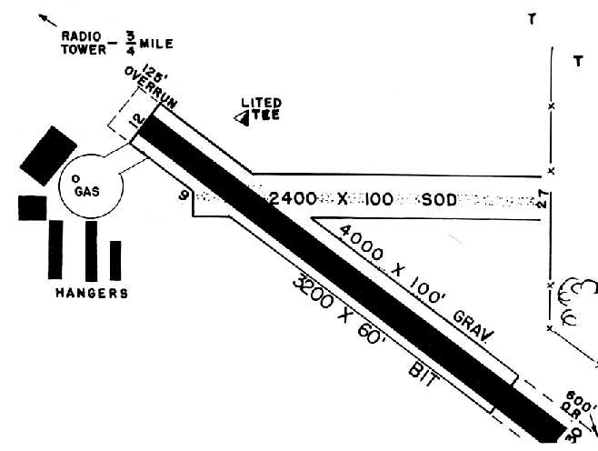
which described Casement Airport as having a 3,200' gravel Runway 13/31 & a 2,200' Runway 9/27.
The earliest depiction of Casement Airport which has been located was a 4/8/62 USGS aerial view.
It depicted the field as having 2 runways, with 2 hangars & 2 light aircraft on the northwest side.
The earliest aeronautical chart depiction which has been located of Casement Airport
was on the 1963 Cleveland Local Aeronautical Chart (courtesy of Mike Keefe).
It described Casement as having 2 runways, with the longest being a 3,200' bituminous strip.
David Tuuri recalled, "My first solo flight was from Casement in July 1963.
My flight instructor began teaching students in his Piper Super Cruiser on the Sidley farm
and Mr. Sidley asked him to go to work for him.
Larry Wilson WAS Casement Airport.
Wolfgang Langewiesche (Stick & Rudder) wrote an article appearing in Readers Digest
about the commuter service Larry set up using Cessna 172's to ferry passengers to & from Cleveland Hopkins Airport
because it was one of the first if not THE first such service in existence.
My first tailwheel experience was on the east/west grass runway."
A June 1964 photo (courtesy of Richard Hess) of a Curtiss Robin & several other aircraft in front of Casement Airport hangars.
Richard reported, “They were in a Civil Air Patrol scrapbook, but these are not CAP planes. It looks like an Air Show or Fly-In Event.”
The 1966 OH Airport Directory (courtesy of Chris Kennedy)
depicted Casement Airport as having a total of 5 hangars on the west side of the field.
The manager was listed as Thomas Jenkins,
and the operator was listed as Casement Aviation, Inc.
Strangely, Casement Airport was not depicted at all on the 1968 USGS topo map.
The 1970 USGS topo map depicted Casement Airport as having a paved northwest/southeast runway,
with a large cluster of hangars was on the northwest side of the field.
The last aeronautical chart depiction which has been located of Casement Airport
was on the May 1970 Cleveland Sectional Chart.
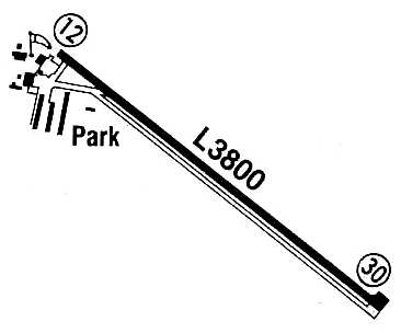
It depicted Casement as having a 3,800' paved northwest/southeast runway.

A 1970 aerial view depicted Casement Airport as having a paved northwest/southeast runway & an unpaved east/west runway.
A group of hangars was on the northwest side of the field,
around which were visible 11 light aircraft.
The 1972 Flight Guide (courtesy of Chris Kennedy)
showed that Casement's paved Runway 12/30 had been somewhat lengthened to 3,800',
and the 2,200' unpaved Runway 9/27 was still open.
By 1982 the crosswind runway had been closed,
as the 1982 AOPA Airport Directory (courtesy of Ed Drury)
described the field as having a single 3,800' asphalt Runway 12/30.
The Casement Airport was owned by R. W. Sidley, Inc.
Casement Airport, as depicted in the 1985 Flight Guide (courtesy of Chris Kennedy).
A 4/4/94 USGS aerial view looking southeast showed 7 single-engine aircraft parked amongst Casement Airport's hangars.
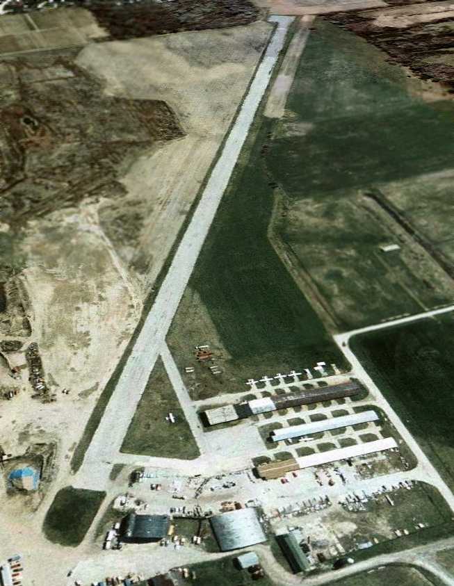
The last photo which has been located showing Casement Airport still in operation was a 2000 aerial view looking southeast.
It did not appear to be a very healthy airport at that point,
as a total of only 6 light aircraft were visible outside in the photo.
There were also a total of 3 rows of T-hangars just south of the western end of the runway,
as well 2 somewhat larger hangars (at the bottom of the photo).
The Casement Airport apparently closed (for reasons unknown) in the year 2000,
as it was not listed among active airfields in the 2000 AOPA Airport Directory.
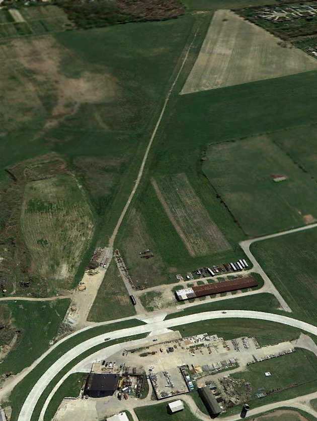
In a 2003 aerial photo, the runway had been marked with closed "X" symbols, and all of the planes were gone.
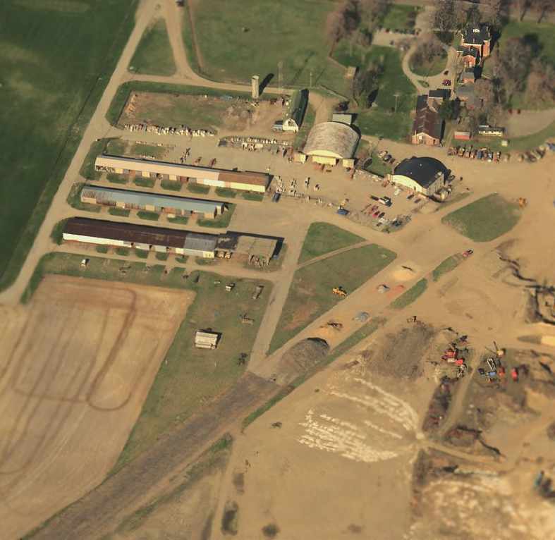
A sad circa 2001-2005 aerial view looking west at the site of Casement Airport
showed that the hangars & runway still remained,
but construction was already evident on the site.
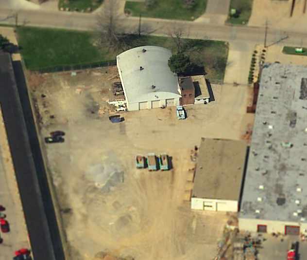
A 6/17/06 aerial photo showed that runway & hangars were still intact.
A 6/1/07 aerial photo showed that the middle row of T-hangars had been removed,
but the runway remained intact.
A 6/5/09 aerial photo showed that the western row of T-hangars & the Quonset-hut hangar had been removed,
along with the majority of the width of the runway pavement.
A 2010 aerial photo showed that a new road was being built through the site of the former T-hangars.
A 4/7/12 aerial view looking southeast showed that the northwest hangar & the eastern row of T-hangars remained standing,
along with portions of the runway pavement.
The site of Casement Airport is located southeast of the intersection of Route 2 & Mantle Road.
Thanks to Chris Kennedy for pointing out this airfield.
____________________________________________________
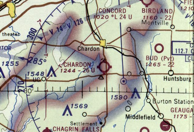
Chardon Airfield (4D6), Chardon, OH
41.54 North / 81.2 West (East of Cleveland, OH)
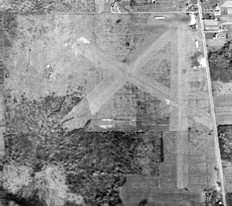
Chardon Airport, as depicted on a 4/1/52 USGS aerial photo.
The date of construction of Chardon Airfield is unknown.
The earliest depiction of Chardon Airfield which has been located
was on the 1943 Cleveland Sectional Chart (courtesy of Chris Kennedy).
However, this was apparently in a somewhat different location than the eventual location of the field,
as the 1943 Sectional depicted Chardon Airfield to the southeast of the town of Chardon
(compared to the southwest of the town, as depicted on later charts).
Chardon was described as having a 2,200 unpaved runway
on the 1949 Cleveland Sectional Chart (according to Chris Kennedy).
The earliest photo which has been located of Chardon Airport was a 4/1/52 USGS aerial view.
It depicted the field as having 3 grass runways,
with 4 small buildings & a single light aircraft on the northeast corner.
The earliest aeronautical chart depiction which has been located of Chardon Airport
was on the 1953 Flight Chart (courtesy of Scott O'Donnell).
It depicted Chardon as having a 2,200' unpaved runway.
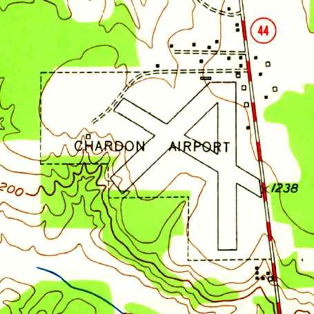
The 1953 USGS topo map depicted Chardon Airport as having 3 runways,
with several small buildings along the northeast side.
According to Keith Alves, the “block hangar at Chardon... came from Cleveland Airport.
But, another hangar was moved at the same time to the sand pit north of the airport.
The owner of the sand pit also owned the airport at that time.
During the 1950s-1960s, the Ohio National Guard had their L-19s based there in the block hangar.”
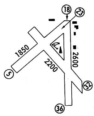
The 1962 AOPA Airport Directory described Chardon as having 3 sod runways:
2,400' Runway 18/36, 2,000' Runway 13/31, and 1,800' Runway 5/23.
The operator was listed as Dethloff Flying Service.
A 1962 aerial view showed a large hangar had been added at Chardon Airfield at some point between 1952-62.
Three light aircraft were parked on the northeast corner of the field.
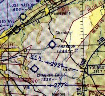
Chardon Airport, as depicted on the 1963 Cleveland Local Aeronautical Chart (courtesy of Mike Keefe).
The last aeronautical chart depiction which has been located of Chardon Airport
was on the May 1970 Cleveland Sectional Chart.
It depicted Chardon as having a 2,600' unpaved runway.
Chardon Airport, as depicted in the 1972 Flight Guide (courtesy of Chris Kennedy).
Hans Friedebach recalled, “Flying in the Cleveland area in the 1970s & 1980s
I was intrigued by the obvious mismatch of the Chardon airfield & its huge hangar.
Until one day the puzzle was solved when I came across an old issue of Fortune Magazine (circa 1930's).
I saw a display ad with line drawings of the Chardon hangar by the construction company.
This explained its origin.”
Bill Meyer reported in 2003, "I had 2 airplanes (in succession) that I based at Chardon.
The building described & pictured however was not really part
of the airport operation during the time I flew there (1975-81).
The property was owned by Walter Best.
He quarried the land to the north of the airport
and kept 2 airplanes in that hangar, one of which was a Helio Courier.
It was also used at that time for some kind of non-aviation manufacturing.
There was an old wood hangar/office to the North of that building which housed Geauga Air.
It was last operated by Richard Gilmore who was a flight instructor and A & P [mechanic].
There were also 2 rows of small T hangars,
one was on the East edge of the field & one on the North edge.
They were not large enough for a C-172. I did keep my Maule in one though.
They were in very bad repair.
Night landings were accomplished with advance notice
when Dick Gilmore would place old smudge pots along the edge of the North/South runway.
Pretty dicey flying on a soft-field in a rural area. Fun airport though."
In the 1982 AOPA Airport Directory (courtesy of Ed Drury),
the airfield configuration remained much the same,
but the operator was listed as Geauga Air Service.
A note was included: "Glider operations (Apr-Dec). Gliders & towplanes land downwind off-runways."
A 1987 photo by John Baker of his Stinson 108-3 which he had flown into Chardon from Maryland.
"The small building that you see behind my plane was used as a clubhouse for the glider group based there.
This ramshackle building was to the north of the large hangar shown in the photo.
There was a parking area for cars just north of the clubhouse."
John Baker recalled of Chardon, "I spent some time there in the mid 1980's
visiting a friend who was a member of the Cleveland Soaring Society that operated out of the field.
I flew my Stinson 108-3 there from Maryland in 1987,
arriving on 7/30/87 & departing on 8/6/87.
So the field was still in operation in 1987."
"The primary runway in use at that time was the north/south runway.
This runway ran parallel to the road, which was just a few hundred feet to the east.
There was a large tree at the north end of the runway.
My friend had an Aeronca 11AC Chief with a sickly Continental A-65 that would barely clear that tree on takeoff.
With both of us in the Aeronca, it was necessary to go around the tree when taking off.
The Aeronca was kept in one of the dilapidated hangars near the north edge of the field.
During my 1987 visit, I got to take a few flights in the gliders based there
and also flew in a visiting Cessna C-34 Airmaster."
Chardon Airport apparently closed at some point between 1987-94,
as it was simply labeled "Landing Strip" on the 1994 USGS topo map,
which typically indicates that the field was no longer open as an operational airport.
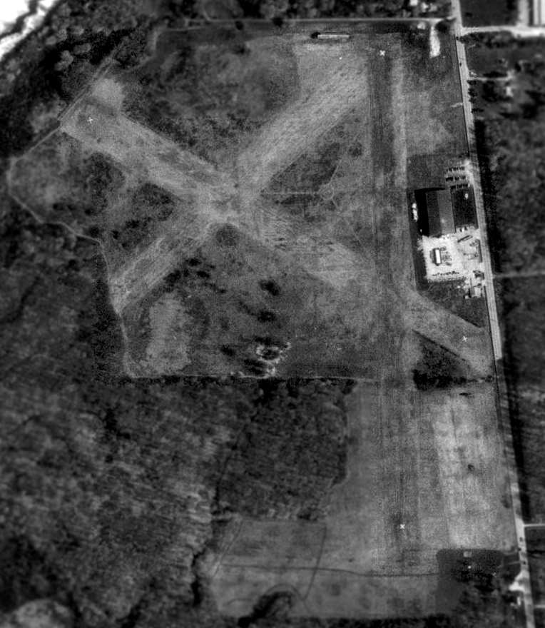
In the 1994 USGS aerial photo, all 3 of the grass runways still existed in very good condition,
with closed runway "X" markings still visible on 2 of them.
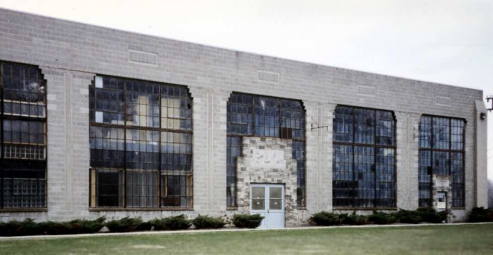
A 1995 photo by Jonathan Westerling of the front of the hangar at Chardon Airfield.
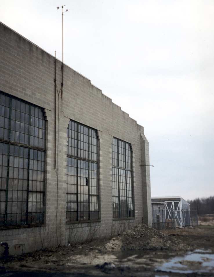
A 1995 photo by Jonathan Westerling of the rear of the hangar at Chardon Airfield.

A 1995 photo by Jonathan Westerling of an elaborate & beautiful sandstone engraving
which remains above the entrance to the front of the hangar at Chardon Airfield.
The abandoned Chardon airfield was visited by Jonathan Westerling in 1995.
He reports, "There had been no development on the airfield,
though the turf runways have grown up with shrubs & small trees.
The only surviving building is the main hangar.
An impressive stone building which now functions as a warehouse for a German manufacturing firm
(complete with a German flag flying atop the flagpole out front!).
This must have been a charming airport in its day."
The airfield was not depicted at all (even as an abandoned airfield) on 1998 aeronautical charts.
Bill Meyer recalled in 2003, "Mr. Best died 10-15 years ago
and the airport property is now being quarried for sand by the Best Stone Company.
Flying over it now, you can still make out the remains of the runways."
Tom Beamer reported in 2003,
"I understand the hangar was moved to Chardon from CLE/Hopkins."
According to Hans Friedebach, “The hangar at Chardon...
was originally built for United & at the time of its construction was billed as the largest clear-span hangar in the country.”
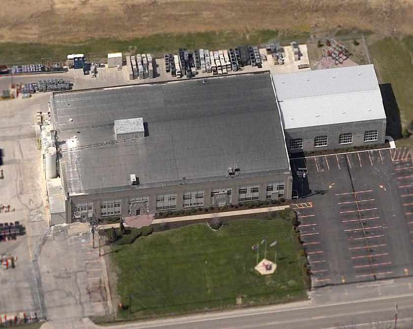
A circa 2001-2005 aerial view looking west at the hangar & other building which remain on the site of Chardron Airfield.
The majority of the western side of the former runway has been replaced by a sand quarry.
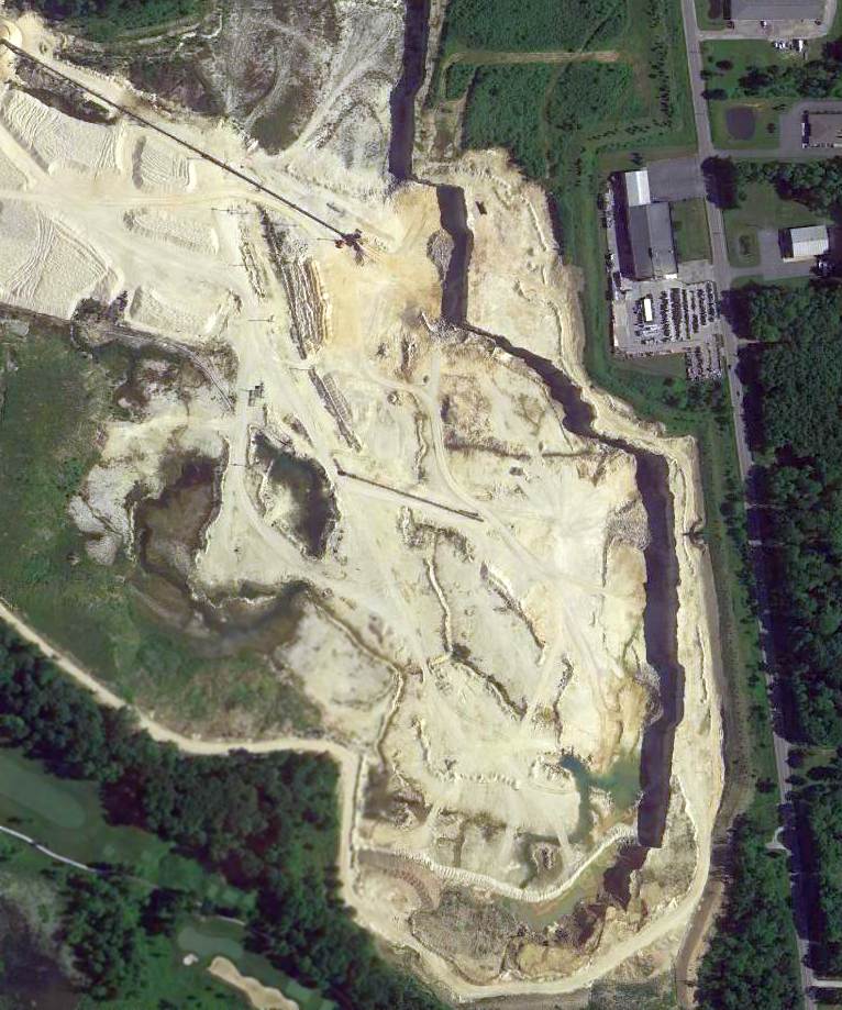
A 2014 aerial view shows the hangar remains on the east side of the Chardron Airfield site,
but the majority of the airfield property had been dug up for a sand quarry.
Chardon Airfield is located northwest of the intersection of Route 322 & Route 44.
____________________________________________________
Since this site was first put on the web in 1999, its popularity has grown tremendously.
That has caused it to often exceed bandwidth limitations
set by the company which I pay to host it on the web.
If the total quantity of material on this site is to continue to grow,
it will require ever-increasing funding to pay its expenses.
Therefore, I request financial contributions from site visitors,
to help defray the increasing costs of the site
and ensure that it continues to be available & to grow.
What would you pay for a good aviation magazine, or a good aviation book?
Please consider a donation of an equivalent amount, at the least.
This site is not supported by commercial advertising –
it is purely supported by donations.
If you enjoy the site, and would like to make a financial contribution,
you
may use a credit card via
![]() ,
using one of 2 methods:
,
using one of 2 methods:
To make a one-time donation of an amount of your choice:
Or you can sign up for a $10 monthly subscription to help support the site on an ongoing basis:
Or if you prefer to contact me directly concerning a contribution (for a mailing address to send a check),
please contact me at: paulandterryfreeman@gmail.com
If you enjoy this web site, please support it with a financial contribution.
please contact me at: paulandterryfreeman@gmail.com
If you enjoy this web site, please support it with a financial contribution.
____________________________________________________
This site covers airfields in all 50 states.