Abandoned & Little-Known Airfields:
Central New Mexico
© 2002, © 2015 by Paul Freeman. Revised 12/24/15.
This site covers airfields in all 50 states: Click here for the site's main menu.
____________________________________________________
Please consider a financial contribution to support the continued growth & operation of this site.
Clines Corners Airport (added 12/24/15) - Transwestern #7 Airfield (revised 6/8/13) - Transwestern #8 Airfield (revised 8/25/13)
___________________________________________________________
Clines Corners Airport, Clines Corners, NM
35.006, -105.673 (East of Albuquerque, NM)
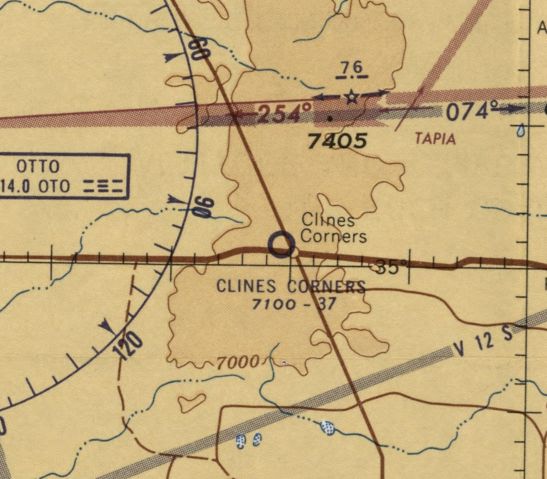
Clines Corners Airport, as depicted on the February 1960 Sectional Chart (courtesy of Matt Franklin).
Photo of the airfield while in use has not been located.
This small general aviation airport on the southwest side of the crossroads of Clines Corners was evidently established at some point in the 1950s,
as it was not yet depicted on 1950s Sectional Charts (according to Matt Franklin).
The earliest depiction which has been located of Clines Corners Airport was on the February 1960 Sectional Chart (courtesy of Matt Franklin).
It depicted Clines Corners Airport as having a 3,700' unpaved runway.
Matt Franklin observed that this chart depicted Clines Corners Airport on the “wrong north side of the interstate, but I think this was a cartography error.”
An article in the 7/6/64 Hobbs Daily News (courtesy of Matt Franklin) entitled “Plane Crash Injures Two”
described a crash of a single-engine aircraft at the Clines Corners Airport after the plane had developed engine trouble & attempted to land at the airport.
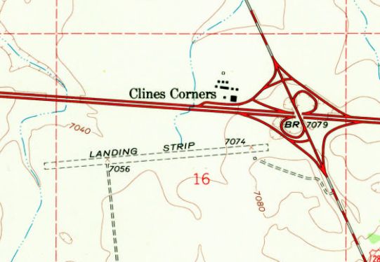
The 1966 USGS topo map depicted Clines Corners Airport as a single east/west unpaved runway, labeled simply as “Landing Strip”.
A single small building was depicted on the southeast side of the runway.
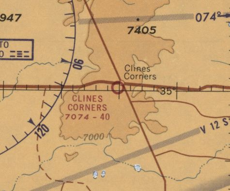
The last aeronautical chart depiction which has been located of Clines Corners Airport was on the February 1968 Sectional Chart (courtesy of Matt Franklin),
which depicted Clines Corners Airport as having a 4,000' unpaved runway.
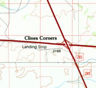
The last topo map depiction which has been located of Clines Corners Airport was on the 1986 USGS topo map.
It depicted a single east/west runway, labeled simply as “Landing Strip”.
The earliest photo which has been located of Clines Corners Airport was a 1996 aerial view looking southwest.
It depicted a single east/west unpaved runway, with a small hangar on the southeast side.
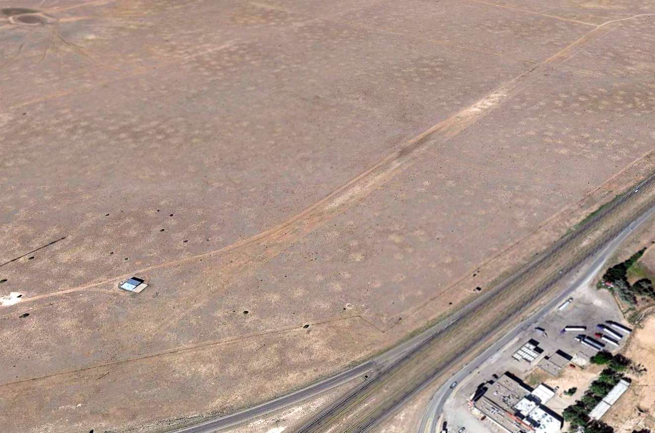
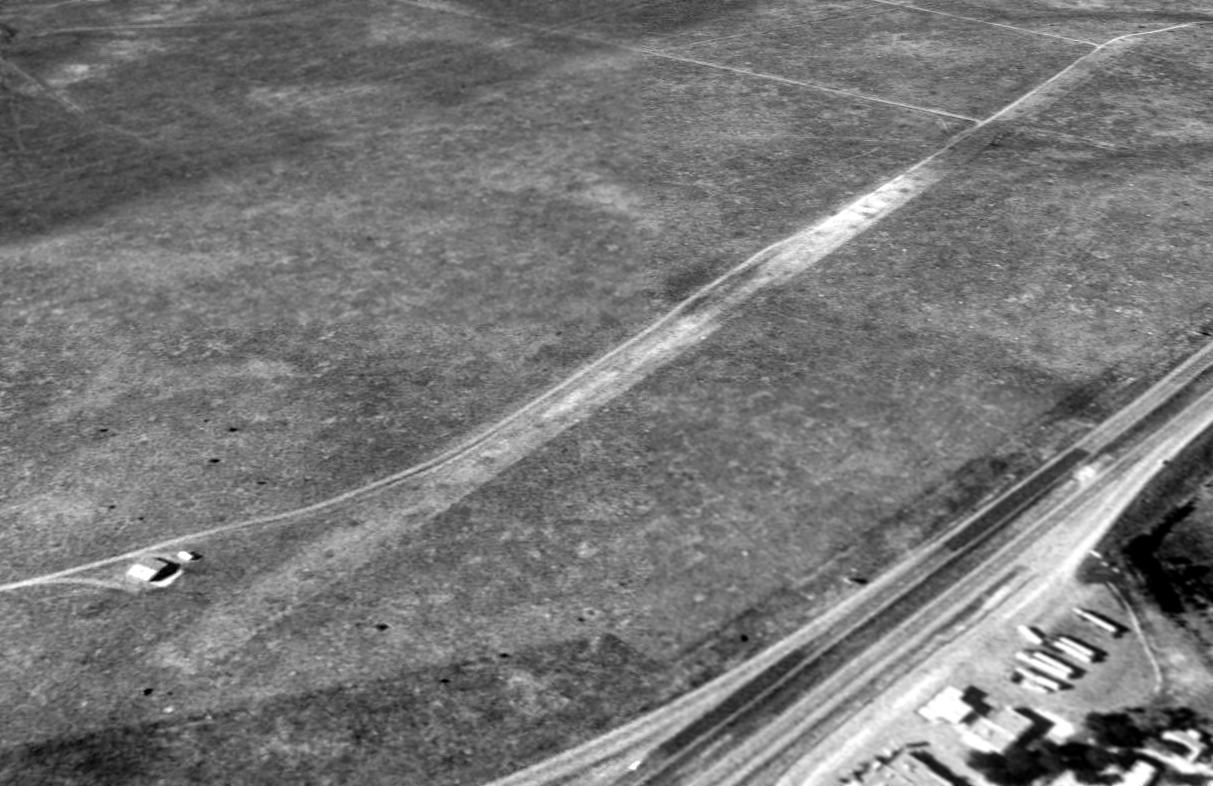
A 2014 aerial view looking southwest depicted the Clines Corners runway & hangar remaining unchanged.
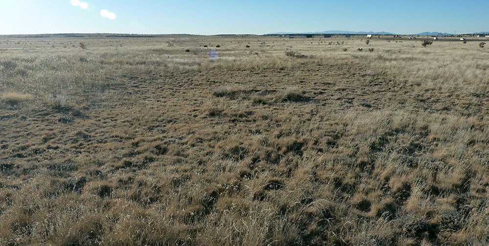
A 2014 photo by Matt Franklin looking west along the Clines Corners Airport runway.
Matt Franklin reported, “I happened to be passing through on my way back to Albuquerque & knew this was located just hundreds of feet from I-40.
I followed a modern dirt road to its termination at a communications tower & took a lesser-traveled path the remainder of the way to the hangar.
There is some compression of the scrub brush but not much. I was struck by the unevenness of the runway towards the western end.”
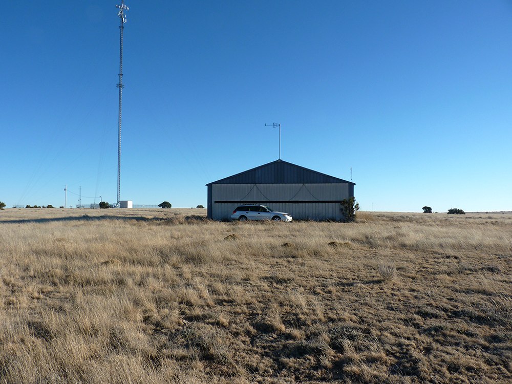
A 2014 photo by Matt Franklin of the Clines Corners Airport hangar.
Matt Franklin reported, “The pictures of the hangar show it to be in good sturdy condition.
I would venture to guess that someone is keeping up the maintenance on this, as it was shut tight so I couldn’t gauge the contents.
There was a side door with pallets leaning around it.
On the eastern plains of New Mexico it can be very windy with no geographical features to break up the wind, and I can recall a rather lonely but sturdy structure standing up to forces.”
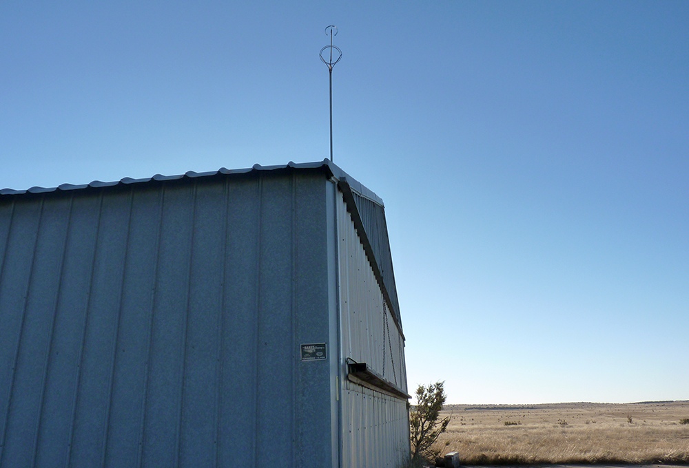
A 2014 photo by Matt Franklin of the Clines Corners Airport hangar.
Matt Franklin reported, “The windsock on top of the roof had been stripped of its canvas.”
The site of Clines Corners Airport is located southwest of the intersection of Interstate 40 & Route 285.
Thanks to Matt Franklin for pointing out this airfield.
______________________________________________________
Transwestern #7 Airfield (77E), Mountainair, NM
34.32, -106.27 (South of Albuquerque, NM)
![]()
"Landing Strip", as depicted on the 1972 USGS topo map.
Photo of the airfield while in use has not been located.
Transwestern #7 was apparently one of a string of former private airfields owned by the Transwestern pipeline company,
whose pipeline runs adjacent to the airfield to the north.
Each of the Transwestern airfields were constructed adjacent to one of a series of compressor stations
located along the pipeline (according to a map located by David Brooks).
The Transwestern #7 Airfield may have been built at some point between 1970-72,
as it was not yet depicted on the February 1968 Albuquerque Sectional Chart nor on the 1970 USGS topo map.
The earliest depiction of the Transwestern #7 Airfield which has been located
was on the 1972 USGS topo map,
which depicted a single 7,600' east/west runway, labeled simply as "Landing Strip".
![]()
The July 1977 World Aeronautical Chart (courtesy of Chris Kennedy)
depicted "Transwestern #7" as a private field having a single 7,300' paved runway.
"Transwestern Pipeline #7" was listed as an active private airfield
in the 1982 AOPA Airport Directory (courtesy of Ed Drury).
It was described as having a single 7,300' asphalt Runway 8/26,
and the remarks said "Private. Use at own risk."
The Transwestern airfields were still depicted on the 1994 CG-19 Regional Aeronautical Chart (according to David Brooks).
The Transwestern #7 airfield was evidently abandoned at some point between 1994-97,
as it was no longer depicted on the 1997 Sectional Chart.
![]()
The Transwestern #7 airfield was apparently closed by 1997,
as 10/14/97 USGS aerial view looking southeast depicted the runway as being painted with "X" closed runway markings.
No buildings or other aviation facilities were visible at the airfield.
The Transwestern #7 Airfield was depicted as an abandoned airfield on the 1998 World Aeronautical Chart.
![]()
A 7/24/11 aerial view looking southeast along the Transwestern #7 airfield showed the runway remained intact though deteriorated.
The Transwestern #7 Airfield is located 15 miles southwest of the intersection of Route 60 & Route 55.
Thanks to Chris Kennedy for pointing out this airfield.
______________________________________________________
Transwestern #8 Airfield (62E), Laguna, NM, Corona, NM
33.924, -105.34 (Southeast of Albuquerque, NM)
![]()
A 9/3/73 USGS aerial photo of the Transwestern #8 Airfield.
Transwestern #8 was apparently one of a string of former private airfields owned by the Transwestern pipeline company,
whose pipeline runs adjacent to the airfield to the south.
Each of the Transwestern airfields were constructed adjacent to one of a series of compressor stations
located along the pipeline (according to a map located by David Brooks).
The Transwestern #8 Airfield was apparently built at some point between 1968-73,
as it was not yet depicted on the February 1968 Albuquerque Sectional Chart.
The earliest depiction of the airfield which has been located was on a 9/3/73 USGS aerial photo,
which depicted Transwestern #8 as having a single northwest/southeast runway.
![]()
The 1981 USGS topo map depicted the Transwestern #8 Airfield as having a single runway,
labeled simply as “Landing Strip”.
![]()
The July 1977 World Aeronautical Chart (courtesy of Chris Kennedy)
depicted "Transwestern #8" as a private field having a single 5,000' paved runway.
Transwestern Pipeline #8 Airfield was listed as an active private airfield
in the 1982 AOPA Airport Directory (courtesy of Ed Drury),
with a single 5,000' asphalt Runway 9/27.

In the 1996 USGS aerial photo the Transwestern #8 runway was clearly marked with closed runway “X” symbols.
Transwestern Pipeline #8 was apparently kept open somewhat longer than the rest of the Transwestern airfields,
as the 1998 World Aeronautical Chart still depicted it as an active private airfield,
with a 5,000' paved runway.
It apparently closed at some point between 1998-2003,
as it was depicted as an abandoned airfield on 2003 aeronautical charts.
Bill Suffa overflew the Transwestern #8 airfield in 2003 and remarked,
"The airfield has big X's along the runway,
but otherwise looks in good condition (as best I could tell at 17,000 ft)."
![]()
A circa 2006 aerial view looking northwest along the Transwestern #8 runway.
The airfield is located in an extremely remote & desolate area, 30 miles southeast of Corona, NM.
____________________________________________________
Since this site was first put on the web in 1999, its popularity has grown tremendously.
That has caused it to often exceed bandwidth limitations
set by the company which I pay to host it on the web.
If the total quantity of material on this site is to continue to grow,
it will require ever-increasing funding to pay its expenses.
Therefore, I request financial contributions from site visitors,
to help defray the increasing costs of the site
and ensure that it continues to be available & to grow.
What would you pay for a good aviation magazine, or a good aviation book?
Please consider a donation of an equivalent amount, at the least.
This site is not supported by commercial advertising –
it is purely supported by donations.
If you enjoy the site, and would like to make a financial contribution,
you
may use a credit card via
![]() ,
using one of 2 methods:
,
using one of 2 methods:
To make a one-time donation of an amount of your choice:
Or you can sign up for a $10 monthly subscription to help support the site on an ongoing basis:
Or if you prefer to contact me directly concerning a contribution (for a mailing address to send a check),
please contact me at: paulandterryfreeman@gmail.com
If you enjoy this web site, please support it with a financial contribution.
please contact me at: paulandterryfreeman@gmail.com
If you enjoy this web site, please support it with a financial contribution.
____________________________________________________
This site covers airfields in all 50 states.