Abandoned & Little-Known Airfields:
New Jersey: Trenton area
© 2003, © 2016 by Paul Freeman. Revised 11/10/16.
This site covers airfields in all 50 states: Click here for the site's main menu.
____________________________________________________
Please consider a financial contribution to support the continued growth & operation of this site.
Forrestal Airport (revised 3/2/16) - Forsgate Airpark (revised 10/23/14) - Hightstown Airport / Hightstown Air Service Airport (revised 11/10/16)
Mahalchik Airfield (revised 3/2/16) - (Original) Mercer County Airport / Trenton-Mercer Airport (revised 8/30/15)
Pennington Airport / Twin Pine Airport (revised 1/2/16) - Phillipsburg Airport (revised 3/2/16) - Princeton Nassau Airpark (revised 1/25/15)
Trenton-Princeton Airport / Trenton Forest Fire Service Airport (revised 9/19/15) - Windsor Airport / Hightstown-Windsor Airport (revised 1/25/15)
____________________________________________________
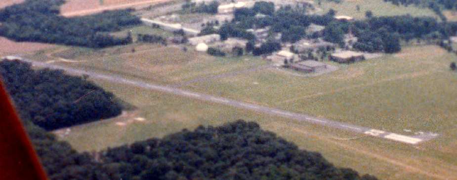
Hightstown Airport, Hightstown, NJ
40.256, -74.537 (Northeast of Philadelphia, PA)
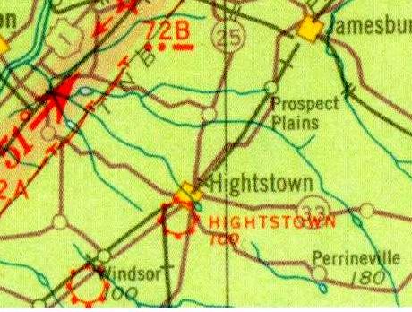
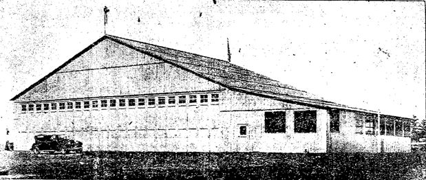
Hightstown Airport, as depicted on the 1934 NY Sectional Chart.
Photo of the airport is not available.
One of the huge number of New Jersey's general aviation airports lost to “progress”.
The date of establishment of Hightstown Airport has not been determined.
The earliest reference which has been located to Hightstown Airport was its listing in the Airport Directory Company's 1933 Airport Directory (according to Jim Stanton).
The earliest depiction which has been located of Hightstown Airport was on the 1934 NY Sectional Chart,
which depicted Hightstown as a commercial/municipal airport.
Hightstown Airport was not listed among active airports in the Airport Directory Company's 1937 Airport Directory (according to Jim Stanton).
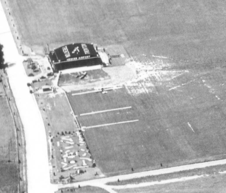
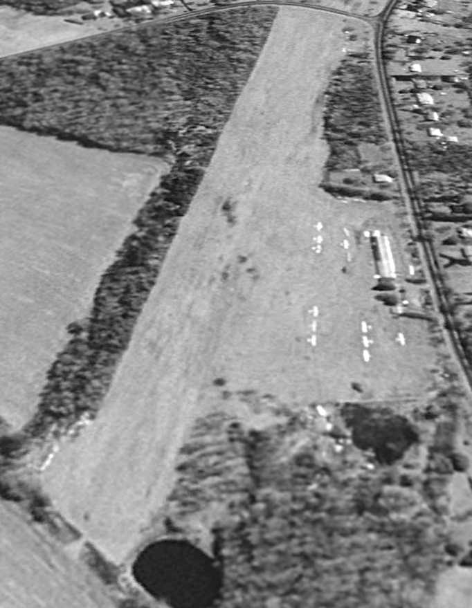
The earliest photo which has been located of Hightstown Airport was a 1940 aerial photo,
which depicted a grass field with a single hangar on the northwest corner.
Hightstown Airport was not depicted on the March 1946 NY Sectional Chart (according to Jim Stanton).
According to George Manser, the airport in Hightstown was also “known as Tony Lanes.
Tony Lane operated a bar & restaurant very close to the airport or on the airport.”
The only photo which has been located showing an aircraft at Hightstown Airport was a 1947 aerial view.
It depicted one single-engine light aircraft parked next to the hangar on the northwest corner, which had a checkerboard-painted roof.
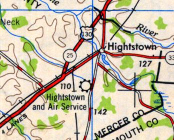
The 1949 USGS topo map depicted “Hightstown and Air Service” as a commercial/municipal airport.
The last depiction which is available of Hightstown Airport was on the 1950 NY Sectional Chart.
It depicted Hightstown as having a mere 1,900' unpaved runway.
Hightstown Airport evidently closed at some point between 1950-53,
as a 1953 aerial photo depicted the oval racetrack of the East Windsor Speedway having been built over the eastern portion of the airport property.
But the hangar remained standing on the northwest corner.
According to Jim Stanton, Highstown Airport “was last depicted on the January 1954 NY Sectional Chart.”
Hightstown Airport was no longer depicted on the 1957 NY Sectional Chart (courtesy of Mike Keefe).
A 1957 aerial view continued to show the East Windsor Speedway on the east side, and the hangar remaining on the northwest corner of the former airport.
A 1963 aerial photo showed the hangar had been removed at some point between 1957-63.
A 1970 aerial photo showed the smaller East Windsor Speedway was replaced by a larger oval track on the southwest portion of the former airport property.
A 2008 aerial view showed the oval outline of the former East Windsor Speedway still remained on the property.
A 2010 aerial view showed housing construction covering the site of Hightstown Airport.
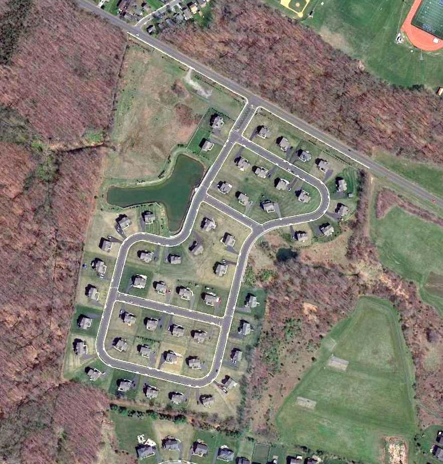
A 2016 aerial photo did not show any trace of Hightstown Airport.
The site of Hightstown Airport was located south of the intersection of Endeavor Boulevard & Airport Road, appropriately enough.
Thanks to George Manser for pointing out this airfield.
____________________________________________________
Windsor Airport / Central Jersey Airport / Hightstown-Windsor Airport, Windsor, NJ
40.24, -74.59 (Northeast of Philadelphia, PA)
Windsor Airport, as depicted on the 1934 NY Sectional Chart (bottom-left airport symbol, just southwest of the town of Windsor).
One of the huge number of New Jersey's general aviation airports lost to “progress”.
The date of establishment of Windsor Airport has not been determined.
Windsor Airport was not yet listed among active airports in the Airport Directory Company's 1933 Airport Directory (according to Jim Stanton).
The earliest depiction which has been located of Windsor Airport was on the 1934 NY Sectional Chart,
which depicted Windsor as a commercial/municipal airport.
The only photo which has been located of Windsor Airport was an undated aerial photo of “Hightstown-Windsor” Airport
from The Airport Directory Company's 1937 Airport Directory (courtesy of Bob Rambo).
The directory described Hightstown-Windsor as a commercial airport located 3.5 miles southwest of Hightstown.
It was said to consist of a 2,200' x 1,500' rectangular sod field, with “Windsor” painted on the hangar.
The directory also listed it under the name of Central Jersey Airport.
Al Bennett Jr. reported, “My father Al Bennett Sr. operated Central Jersey Airport in the 1930s.”
According to Jim Stanton, “Al Bennett was known as the 'world's greatest airplane salesman' during that period.
He was selling a new airplane every 2 weeks as well as many used aircraft.”
According to Jim Stanton, “Windsor / Central Jersey Airport was likely closed immediately after the Pearl Harbor attack
(all civilian flying was banned along the coastal areas except for activity such as Civil Air Patrol)
and apparently did not reopen after the war.”
Windsor Airport was no longer depicted on the 1945 NY Sectional Chart or subsequent charts.
A 1947 aerial view did not show any recognizable indication of an airport, just what appeared to be farm fields.
Jim Stanton reported, “I drove by the location many times. I believe the first time was around 1962.
A NJ historian confirmed that the hangar was still there when he moved to the area around 1970.
I believe the hangar was there in the early 1980s.”
A 2013 aerial photo did not show any trace of Windsor Airport.
Although the precise location of the site of Windsor Airport has not been determined,
it was located approximately west of the terminus of South Main Street.
____________________________________________________
Forsgate Airpark, Jamesburg, NJ
40.344, -74.461 (Northeast of Philadelphia, PA)
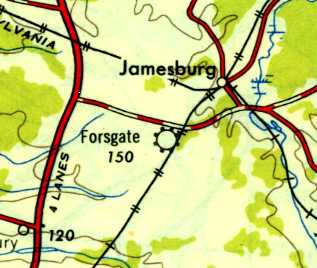
Forsgate Airpark, as depicted on the 1948 USGS topo map.
Yet another of New Jersey's disproportionate share of small airfields lost to “progress”.
According to the 1/15/47 Trenton Evening Times (courtesy of Mark Hess), Forsgate opened on 2/1/47.
According to the Forsgate Country Club, “Long before commercial aviation was popular, John Abeel built Forsgate Airpark in 1947;
despite the public outcry that air travel would hurt agricultural productivity.
It was said that the noises and fumes of the planes were sure to ruin egg production & cause stillborn calves.
But Abeel built anyway, dispelling the community’s fears & creating a fliers’ Mecca.
Small private planes would cruise over the beautiful Charles Banks golf course & land on the green sod runways.
Forsgate employees would spot the planes & send out a red 'Follow Me' jeep to guide the pilot & his golf clubs to the Country Club,
where for 75 cents he could eat a hearty breakfast, or order a mouth-watering dinner for $1.25.
Eventually, commercial airports forced Forsgate Airpark to close, but its hospitality to pilots remains legendary.”
A 1947 aerial photo depicted what may have been Forsgate's grass northeast/southwest runway
adjacent to the west side of its golf course.
There were no aircraft visible on the field.
The earliest map depiction which has been located of Forsgate Airpark was on the 1948 USGS topo map,
which depicted Forsgate as a municipal/commercial airport.
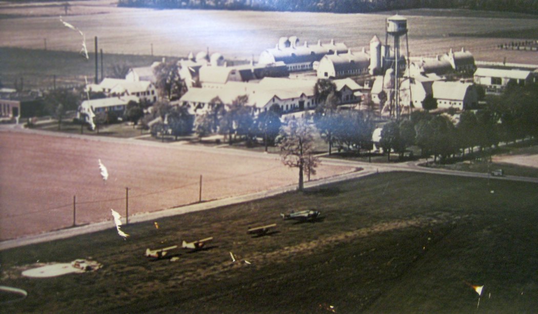
The only photo which has been located showing aircraft at Forsgate Airpark was an undated (circa late 1940s?)
aerial view of 4 aircraft (including a Lockheed twin) on the grass airfield,
with the farm buildings & dairy in the background (courtesy of Thomas Saunders, Golf Course Superintendent of Forsgate Country Club).
Thomas observed, “The Turnpike had not been built yet which would indicate pre-1951.”

The only aeronautical chart depiction which has been located of Forsgate Airpark was on the 1950 Sectional Chart (courtesy of Mike Keefe).
It depicted Forsgate as having a 3,000' unpaved runway.
George Manser recalled, “It was a favorite of the elites as they would flying in for the days with fine dining & other luxuries.
I went there to pick up an aircraft which a student wisely landed there due to declining conditions; best guess 1953.”
The 1953 USGS topo map depicted Forsgate Country Club but did not depict Forsgate Airpark.
Forsgate Airpark evidently closed (for reasons unknown) at some point between 1953-57,
as it was no longer depicted on the 1957 Sectional Chart (courtesy of Mike Keefe).
A 1957 aerial photo depicted the presumed grass runway remained clear.
A 1963 aerial photo showed the golf course had expanded over the location of Forsgate Airpark.
A 9/20/10 aerial photo did not show any trace of Forsgate Airpark, with the site having been covered with houses & other buildings.
The site of Forsgate Airpark is located northeast of the intersection of Links Drive & Forsgate Drive.
Thanks to George Manser for pointing out this airfield.
____________________________________________________
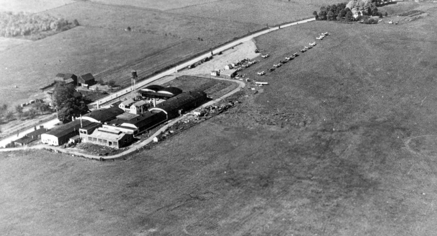
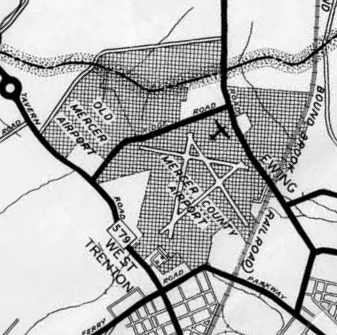
Mercer County Airport (original location) / Trenton-Mercer Airport, Trenton, NJ
40.28, -74.83 (Northeast of Philadelphia, PA)
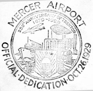
A postmark commemorated the 10/26/29 Dedication of Trenton Mercer Airport (courtesy of the Hamilton Historical Society, via Mark Hess).
The original Mercer County Airport was located adjacent to the northwest side of the present-day Mercer County Airport.
A postmark commemorated the 10/26/29 Dedication of Trenton Mercer Airport.
The earliest depiction which has been located of Mercer Airport was an undated photo of 3 Keystone amphibians from the 1/3/31 Trenton Advertiser (courtesy of Tony Richardson).
It was captioned “Air yachts from Keystone plant fill Mercer Airport hangar to capacity.
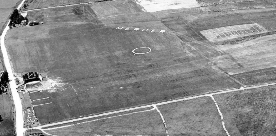
A 8/18/31 aerial view looking north depicted Mercer Airport as an open grass field with a single hangar on the west side,
an airport circle marking in the center of the field, and the word “Mercer” prominently written in the grass along the northern edge.
A closeup from the 8/18/31 aerial view looking north at the Mercer hangar, showing 2 aircraft in front of the hangar.
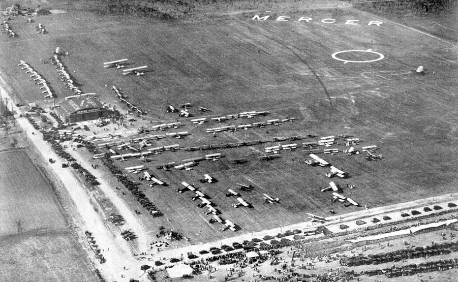
A 1934 aerial view looking north depicted Mercer Airport during some type of air show,
with large numbers of aircraft & spectators on the field (courtesy of the Hamilton Historical Society, via Mark Hess).
An undated aerial view looking north at Mercer Airport
from a circa late 1930s Airfield Directory Company Airfield Directory (courtesy of the Hamilton Historical Society, via Mark Hess).
A 6/21/41 aerial view looking south at “Mercer County Airport (Old)” from the 1945 AAF Airfield Directory (courtesy of Bob Rambo).
It depicted the “Mercer County Airport (Old)” as an open grass field with some small buildings on the west side.
Michael Darling reported, “Mercer Airport was the base for the Trenton detachment of the Civil Air Patrol during the war,
of which my grandfather James Darling was an officer.”
The 1945 AAF Airfield Directory (courtesy of Scott Murdock) described “Mercer County Airport (Old)” as a 305 acre rectangular property
having 2 sod runways, measuring 2,500' northeast/southwest & 2,400' east/west.
The field was said to have 3 hangars, the largest of which was a 120' x 40' metal structure.
Mercer County Airport was described as being owned by private interests, but “Not in operation”.
It may have been temporarily closed during WW2, like many other small civilian airports.
The last photos which have been located of the original Mercer Airport included a circa 1946-49 aerial view looking west by CAP Sgt. W. Egge (courtesy of Bruce Reid).
It depicted a dozen light aircraft parked to the northwest of the hangars.
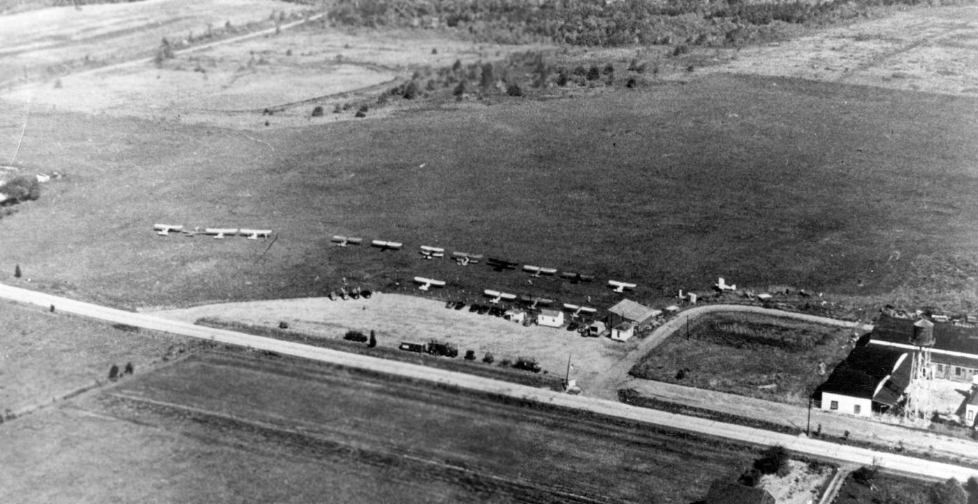
The last photos which have been located of the original Mercer Airport included a circa 1946-49 aerial view looking east by CAP Sgt. W. Egge (courtesy of Bruce Reid).
It depicted a dozen light aircraft parked to the northwest of the hangars.
Michael Darling reported, “Mercer Airport in Trenton was a small grass strip run by my grandfather [James Darling] in the 1940s – 50s.
The county leased the old Mercer Airport out to different operators; he operated it with a couple of partners from just after WWII until it became the country club.”
Mercer County Airport, as depicted on the 1947 USGS topo map.
A 1947 aerial photo depicted several light aircraft parked along the west side of the original Mercer County Airport.
The only aeronautical chart depiction which has been located of Trenton-Mercer Airport was on the 1950 NY Sectional Chart,
which depicted “Trenton-Mercer” as having a 2,500' unpaved runway.
The original Mercer County Airport was presumably closed at some point between 1950-53,
as a 1953 aerial view showed a closed “X” symbol added over the circle marking in the center of the airfield.
The airfield remained clear, and the complex of hangars & buildings on the west side remained intact,
but the field was devoid of aircraft.
The last depiction which has been located of the original Mercer Airport was on a 1956 Mercer County map (courtesy of Micheal Darling).
A 1957 aerial view showed the complex of hangars & buildings on the west side of the original Mercer County Airport remained intact,
but several new roads had been built across the former airfield.
A 1958 aerial view showed that a golf course had begun to be constructed over the majority of the site of the original Mercer County Airport.
The original Mercer County Airport was no longer depicted on the 1964 NY Local Aeronautical Chart (courtesy of John De Nicola).
A 1979 aerial view showed the complex of hangars & buildings on the west side of the original Mercer County Airport remained intact.
The hangars on the west side of the site of the original Mercer County Airport were evidently removed at some point between 1979-95,
as a 1995 aerial view showed several new office buildings having been built on the site.
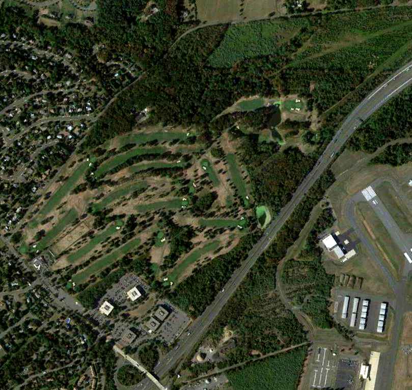
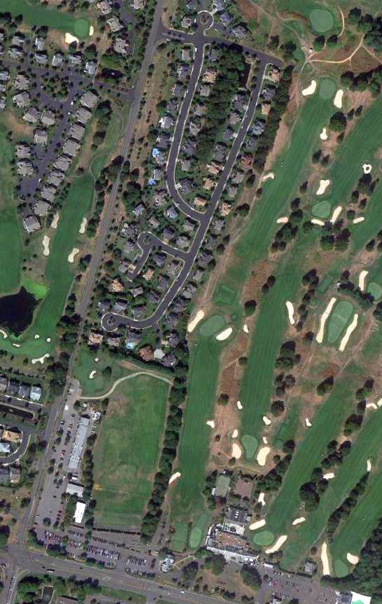
A 9/21/10 aerial photo did not show any trace of the original Mercer County Airport, with a golf course covering the site.
Note the runways of Trenton-Mercer Airport, immediately adjacent to the southeast.
The site of the original Mercer County Airport is located north of the intersection of Interstate 95 & Bear Tavern Road,
adjacent to the northwest side of Trenton-Mercer Airport.
____________________________________________________
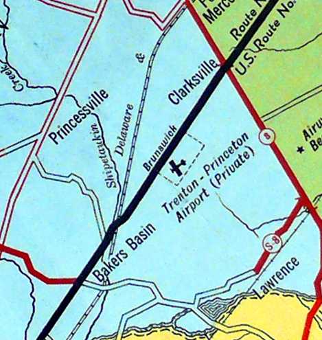
Trenton-Princeton Airport / Trenton Forest Fire Service Airport, Clarksville, NJ
40.29, -74.688 (Northeast of Philadelphia, PA)
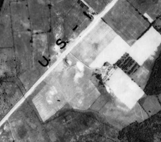
An undated photo of the Trenton-Princeton Airport's original hangar, from a 10/27/29 article (courtesy of Dennis Waters).
This small airport was located on the northeast side of Trenton.
According to a 1929 Trenton Evening Times article (courtesy of Dennis Waters),
“The Trenton-Princeton Airport Inc. was granted permission to construct a flying field on the Seely-Rostron Farms, Lawrence Township.
Hangars will be erected, and a flying school established.”
According to Dennis Waters, “Plans for the new 'Trenton-Princeton Airport' were revealed in early 1929.
The organizers of the venture were two executives from the Hun School, Edward Stevens & Robert Lechner, and Joseph Wetzel, a well-known mechanic from Trenton.
Later that year the trio constructed their airfield & hangar on a strip of land along Brunswick Pike that had been part of the Seely-Rostron farm.
It comprised two 1,500' sod runways oriented north/south & east/west.
The first notice of the new airport venture was published in the 3/14/29 Trenton Evening Times.”
Tom Kramer reported, “In 1978 I was working for the state of NJ with a geodetic survey crew.
We had drawings of each point in the state & it's location to telephone poles, curbs & other buildings.
Lo & behold, there was a point located at the corner of a hangar at the Trenton Airport, but not the current one (TTN) or even the one that it replaced.
It was the one on Route 1. The drawing was dated around 1929.
The airport was located where the current Motor Vehicle Inspection Station is near the intersection of Route 1 & Interstate 95/295.”
The earliest photo which has been located of the Trenton-Princeton Airport
was an undated photo of its original hangar from a 10/27/29 article (courtesy of Dennis Waters).
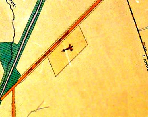
The Trenton-Princeton Airport, as depicted on a 1930 Township Plan for Lawrence Township (courtesy of Dennis Waters).
The earliest aerial view which has been located of the Trenton-Princeton Airport
was a 1930 aerial view (from the NJ Geographic Information Network, courtesy of Dennis Waters).
A single newly-constructed hangar is visible just below the “US-1” label.
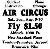
An advertisement for an 8/9/30 Air Circus at Trenton-Princeton Airport from the 8/8/30 Trenton Evening Times (courtesy of Dennis Waters).
According to Dennis Waters, “During the 1930s it operated as a small general aviation airfield,
offering flying lessons, servicing aircraft, and hosting the occasional air show.”
The only depiction which has been located which labeled the Trenton-Princeton Airport
was a 1932 Mercer County Map (courtesy of Dennis Waters).
It also denoted an Airway Beacon a short distance to the east, on the opposite side of Route 8.
According to Tony Richardson, “Trenton Airport... was owned by the Forest Fire Service
and operated as an airport & firefighting vehicle repair shop” starting in 1940.
According to Dennis Waters, “In 1941 it was taken over by Plainsboro farmer Isaac Barlow, who established the 'Isaac Barlow & Son Aircraft Division' there.
Barlow’s son Edward owned farmland adjacent to the airport.
Barlow’s ownership was short-lived, however. In 1942, with the war on, the airfield was taken over by the state of New Jersey.”
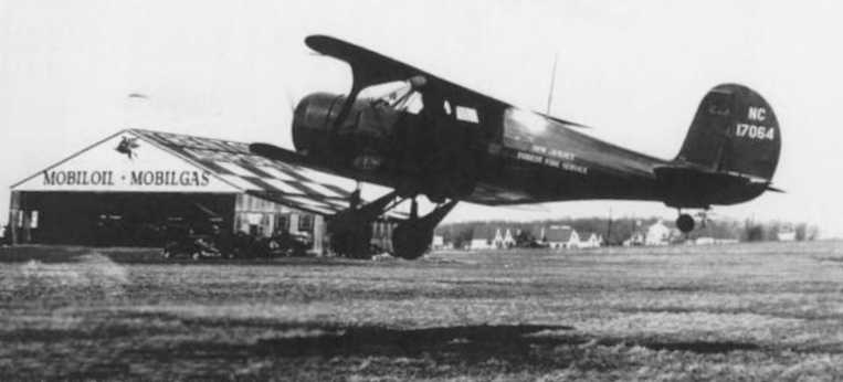
A circa 1940-56 photo of a NJ Forest Fire Service Beech Staggerwing at the Trenton Forest Fire Service Airport (courtesy of Tony Richardson),
with a hangar in the background with “Trenton Airport” & a checkerboard pattern on the roof.
A circa 1943-45 aerial view looking north from the 1945 AAF Airfield Directory (courtesy of Scott Murdock)
depicted “Trenton Airport” as consisting of a grass field with a single hangar.
The 1945 AAF Airfield Directory (courtesy of Scott Murdock) described Trenton Airport as a 40 acre irregularly-shaped property
having two 1,500' sod runways, oriented north/south & east/west, and a single 80' x 60' hangar.
Trenton Airport was described as being owned by the State of NJ, and operated by the State of NJ Forest Fire Service.
The earliest aeronautical chart depiction which has been located of Trenton Airport was on the 1945 NY Sectional Chart (courtesy of Norman Freed),
which depicted “Trenton” as an auxiliary airfield.
The 1947 USGS topo map labeled the airport simply as “Trenton”.
The last aeronautical chart depiction which has been located of Trenton Airport was on the 1950 NY Sectional Chart,
which depicted “Trenton” as having a 1,500' unpaved runway.
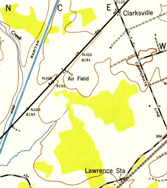
The 1952 USGS topo map simply labeled the site as “Air Field”, but only depicted one small building, and no other airfield layout.
According to Tony Richardson, a hangar on this property was visible in a 1953 aerial photo.
According to Dennis Waters, “Until the mid-1950s, the state used the field as a base for spotter planes of the NJ Forest Fire Service.
By then it had become known as the 'Old Trenton Airport.'”
A 1954 road map (courtesy of Dennis Waters) no longer depicted an airfield at the site.
According to Dennis Waters, “In 1955 the state announced plans to use the site to construct a new headquarters for the Division of Motor Vehicles.”
According to Tony Richardson, the operation of Trenton Airport by the Forest Fire Service ended in 1956.
The 1956 USGS topo map no longer depicted an airfield at the site.
According to Tony Richardson, “The hangar appears demolished in the 1957 aerial photo, as this was when the NJ Motor Vehicle Commission was being built at the site.”
According to Dennis Waters, “The DMV began operation there in 1957.”
According to Tony Richardson, “The 1963 aerial photo shows no trace of the hangar or airport.”
A 9/21/10 aerial photo did not show any trace of the Trenton Airport.
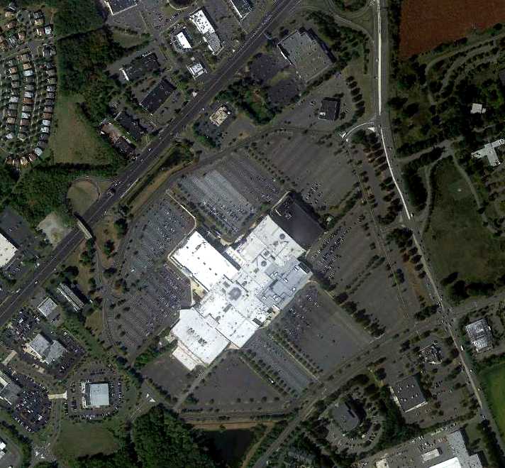
Tony Richardson reported in 2012 that the site of the Trenton Airport “today is the site of the NJ DMV... just to the southwest of Quakerbridge Mall.”

A 2015 or earlier photo by Dennis Waters, who reported in 2015 that “The new NJMVS Baker’s Basin offices were constructed on the site of the original Trenton-Princeton Airport hangar.”
____________________________________________________
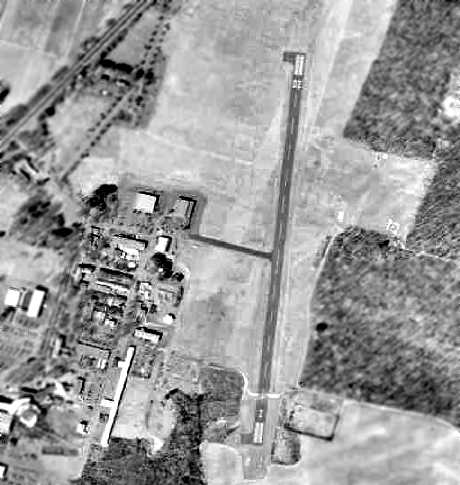
Pennington Airport / Twin Pine Airport (N75), Pennington, NJ
40.31, -74.76 (Northeast of Philadelphia, PA)
Pennington Airport, as depicted on the 1947 USGS topo map.
Yet another privately-owned general aviation airport lost to a municipal government's desire to appropriate the property for other uses.
The Pennington Airport was not yet depicted on a 1940 aerial photo,
and it was not listed among active airfields in the 1945 AAF Airfield Directory (courtesy of Scott Murdock).
Nothing was yet depicted at this location on a 1940 aerial photo.
Some sources indicate the airport was established in 1945 (a year which saw a tremendous explosion in the number of U.S. airports),
but this has not been substantiated.
The earliest depiction which has been located of the Pennington Airport was on the 1947 topo map.
The earliest photo which has been located of the Pennington Airport was a 1947 aerial view.
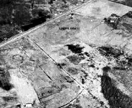
It depicted the field as having a single east/west grass runway, with several small buildings & 4 single-engine aircraft on the south side.
The earliest aeronautical chart depiction which has been located of Pennington Airport
was on the 1950 NY Sectional Chart (courtesy of Mike Keefe).
It depicted Pennington as having a 2,400' unpaved runway.
The earliest photo which has been located of Pennington Airport was a 4/22/53 USGS aerial view,
which did not depict a single aircraft.
Pennington Airport may have closed (for reasons unknown) at some point between 1950-55,
as it was no longer depicted on the 1955 NY Sectional Chart.
The airport was purchased by William Weasner in 1956.
According to Weasner's obituary, “The airport was his life.
Bill was never happier than when he was building or repairing aircraft, helping others do the same, or flying his Staggerwing Beechcraft airplane.”
A 1957 aerial photo of Pennington Airport only depicted one aircraft on the field.
According to a report by the NJ Aeronautics Commission,
airport owner William Weisner complained that Hopewell Township's interference made it difficult for his airport to survive economically.
In 1957, the Township restricted him to having only 3 aircraft on the field.
Kim Dexheimer recalled of Pennington Twin Pine Airport,
“As a kid I remember planes lined up close to the road. Quite a few all different sizes.
Largest being C-47 size. Biplanes, WWII single-seaters & 2-seaters too. It was a great place to go & watch as a kid.”
Pennington Airport was not depicted on the 1958 NY Sectional Chart.
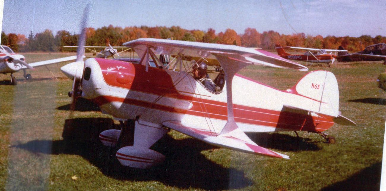
A 1960s photo of Michael Rovello in his restored Pitts Special aerobatic biplane at Twin Pine Airport.
Michael Rovello recalled, “I was taught to fly at Twin Pine Airport by a former Navy instructor named Walt Fawcett in 1962.
I subsequently became a flight instructor & taught flying at Twin Pine until the airport closed.
With Bill Weasner's assistance I restored 5 antique airplanes on the field: a J-3 Cub, a Luscomb 8E, an Aeronca Champ,
a Pitts Special, and a Bucher Jungmann - which is now in an English museum.
An Aeronca Champ took off from Twin Pine Airport without a pilot & ended up in a field in South Jersey when it ran out of fuel.”
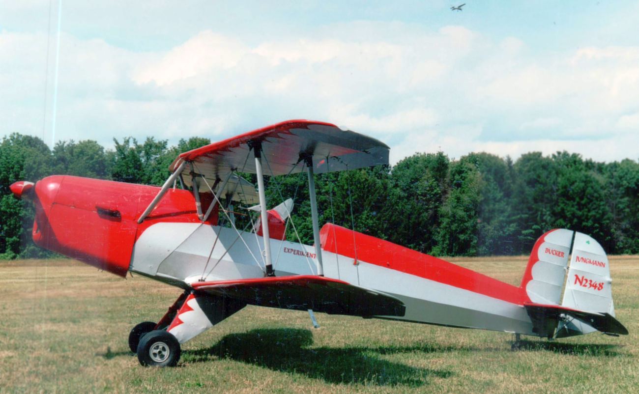
A 1960s photo by Michael Rovello of his restored Bucher Jungman biplane at Twin Pine Airport.
The airport was evidently reopened under a new name, Twin Pine Airport, at some point between 1958-65,
as Twin Pine Airport was depicted on the 1965 NY Sectional Chart with a 2,200' unpaved runway.
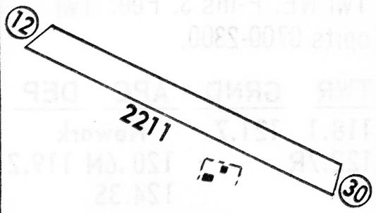
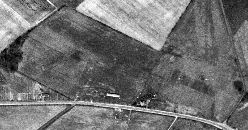
The 1968 Flight Guide (courtesy of Robert Levittan) depicted Twin Pine Airport as having a 2,211' unpaved Runway 12/30,
with 2 small buildings on the south side.
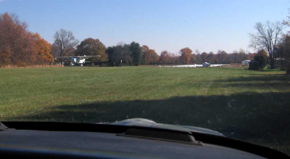
A 1969 aerial photo continued to depict growth of Twin Pine Airport's usage, with over 2-dozen aircraft visible on the field.
A 1969-70 photo by Keith Caulton of a Cassutt racer named Idjet's Midget at EAA Chapter 176’s 1968 Twin Pine Airport Fly-in.
Gary Fitton reported, “My wife & I, and our 2 small children are standing in front of the biplane in the background!
Since the youngest was born in October 1968, this is probably a 1969 or 1970 fly-in.”
Keith Caulton recalled, “The picture of the Cassutt was taken on my first visit to Twin Pine.”
Keith Caulton recalled that he took flying lessons at “Al Dietrich's operation at Twin Pine where I flew with Bert Schwartz.”
A 1970 aerial photo of Twin Pine Airport depicted 29 aircraft on the field.

The 1981 USGS topo map depicted Twin Pine Airport as having a single unpaved northwest/southeast runway, with a few small buildings along the south side,
labeled simply as “Landing Strip”.
According to a report by the NJ Aeronautics Commission,
in 1972, after a 15-year legal battle, Hopewell Township's restriction to the airport having only 3 aircraft on the field was overturned.
A 1972 aerial photo depicted Twin Pine Airport perhaps at its peak of popularity, with a total of 37 aircraft visible on the field.
The February 1975 Philadelphia Terminal Aeronautical Chart (courtesy of Mitchell Hymowitz)
depicted Twin Pine as having a 2,300' unpaved runway.
A 1976 photo by Keith Caulton of hailstorm damage to a Cub. The hailstorm reportedly damaged almost all of the aircraft based at Twin Pine.
The damage to the HedgeHoppers Cub required a complete recovering job.
Someone tried to count the holes in one wing of the Cub, but lost count at some point over 200.
Keith Caulton recalled, “I was the president of the Hedgehoppers flying club.
We owned the Cub for just short of 30 years.”
A 1979 aerial photo of Twin Pine
Airport depicted 30 aircraft on the field.
Walt Stepek recalled, circa 1980, “I opted to train at Twin Pine. There are an awful lot of stories that could be told about that place.
Among some local pilots, it was referred to as 'Outlaw Junction.'
One thing I remember about the hangar facing Pennington Lawrenceville Road was an open bay containing a disassembled Johnson Rocket stuffed in sideways.
I wonder what ever became of that?
Somewhere in my archives I have a picture of me sitting in the pilots seat of the decomposing Beech 18 that sat in the woods for years.”
The 1981 USGS topo map depicted Twin Pine Airport as having a single unpaved northwest/southeast runway, with 2 small buildings along the south side.
The last aeronautical chart depiction which has been located of Twin Pine Airport
was on the June 1982 NY Terminal Aeronautical Chart (courtesy of Mitchell Hymowitz).
It depicted Twin Pine as having a 2,300' unpaved runway.
According to a report by the NJ Aeronautics Commission,
in 1982, Twin Pine Airport submitted an application to build hangars for aircraft.
This was rejected because the zoning board zoned the airport as residential. Therefore, hangars constituted a nonconforming use.
A 3/14/95 USGS aerial view looking east at Twin Pine Airport depicted a total of 13 light aircraft parked on the south side.
A 4/4/04 photo by Nolan Huizenga of a rare Varga 2150A Kachina (N8274J cn VAC-120-79) rotting away in the grass at Twin Pine Airport.
A sad sight – a 4/4/04 photo by Nolan Huizenga of a Ryan Navion A (N514K cn NAV-4-2040) minus its empennage at Twin Pine Airport.
Twin Pine Airport was home to many aircraft in its years, such as a famed Boeing 450 Stearman,
nicknamed the "Red Baron", which regularly gave rides from the grass strip.
The Twin Pine Airport property was valued at $500,000 in 2005,
but after the county ordered revaluations it was assessed at nearly $2,000,000.
This caused a property tax increase from $17,000 to more than $36,000 per year, which in turn caused the owner to sell the airport.
A 2006 article reported, “Jean Weasner & William Weisner, who owns the airport, told the committee that a developer has offered $2.5 million for the tract.
But the Weasners want the airstrip to remain open fields & possibly continue to be used for aviation."
Even the mayor grew up as a pilot there: Mayor Vanessa Sandom said the township would try to preserve the airstrip but did not know whether it would be possible.
"I'm conflicted," she told Weasner. "Actually, I can fly. I got my pilot's license when I was 16.
My dad used to take me to the airfield before I could drive. It was my way of reaching the stars."
In 2006, the towns of Hopewell Township, Lawrence Township, Hopewell and Pennington
applied for $2 million in grants from Mercer County to turn the airport into athletic fields.
Some people associated with the airport considered the actions of the local governments "stealing" by use of taxes.
Costs of keeping the airport (including tax increases that peaked at a 220% increase in one year for the airport) left the Weisner's no choice except to sell the land.
Heaven forbid that a private property owner would be allowed to maintain green space which also serves the local aviation community.
But in this case, the local government had their eye on the property, intent on converting it into soccer fields.
How many other small privately-owned airports will we lose to this kind of maneuver?
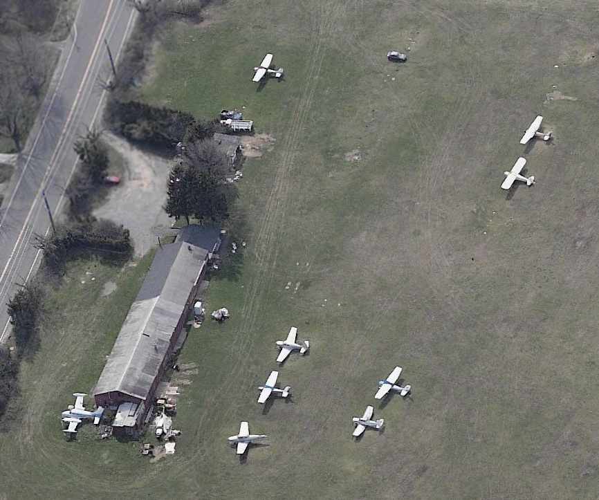
A circa 2006-2010 aerial view looking west at 9 light aircraft at Twin Pine Airport.
A January 2006 photo of a few planes next to the Twin Pine hangar.
A 11/3/06 photo by Tony Richardson of the Twin Pine runway.
Tony recalled, the photo “is from an EAA Chapter 176 meet.
I got my first flight out of this airport in a Piper Tomahawk.
In the picture, the plane is taxiing to runway 30, there is a Piper holding short, and a Cessna 150 flaring.”
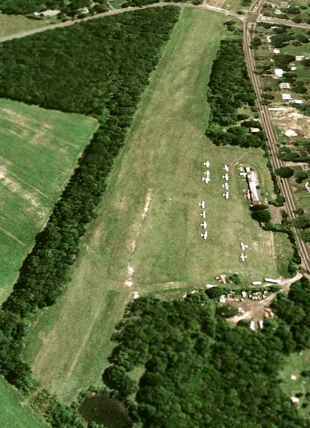
A 7/5/07 aerial view looking east at Twin Pine Airport showed a total of 14 aircraft on the south side.
In its last year of operation, Twin Pine Airport's FAA Airport/Facility Directory data
described the field as consisting of a total of 52 acres, having a single 2,200' turf Runway 12/30,
and listed the owner as William Weasner.
It listed a total of 15 aircraft based on the field, which was said to conduct an average of 32 takeoffs or landings per day.
Tony Richardson reported on 4/3/08, “There was a Navion based at Twin Pine that my dad & I were trying to save from being scrapped.
When I realized it was missing, some people working in the hangar told me that it was stolen.
Wings were cut off & the plane was sold to scrappers.
Also, the other aircraft stranded at Twin Pine have been moved near the main road so they might either be saved or sold.”
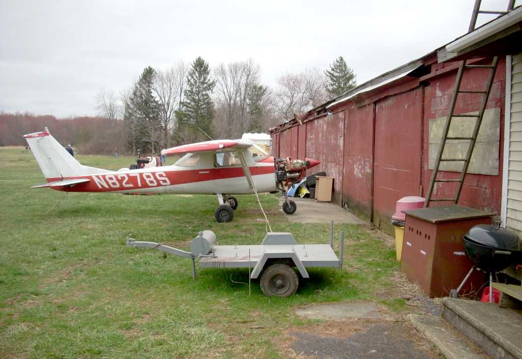
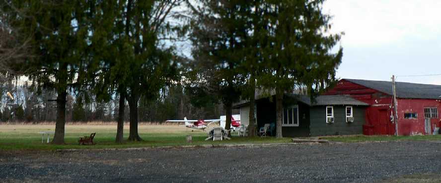
A 4/6/08 photo by Gary Fitton of N8278S, a 1965 Cessna 150, seen at Twin Pine Airport on its closing day.
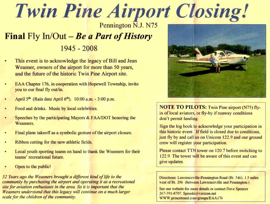
The program for Twin Pine Airport's 4/6/08 Final Fly In / Out (courtesy of Gary Fitton), held by the airport's EAA Chapter 176.
Gary Fitton recalled, “That ceremony was heart-wrenching, seeing Bill sitting there with tears streaming down his face as the politicians took away his airport.”
Tony Richardson recalled, “I was fortunate to ask a few questions from Mr. Weasner on the closing ceremony.
I asked him why people keepmistakingthe airport's name and calling it 'Twin Pines' as it sometimes has said in the local papers.
Mr. Weasner told her that he used to run the Twin Pine hobby shop in the town of Pennington.
There were 2 pine trees right outside of the shop. The shop is still there, he said, minus one tree.
Another topic I asked him about was thepeculiarsight of the Cessna sitting near a house a fewhundredfeet from Runway 30, off the airport property.
He told me the Cessna 150, N8990S, was owned by a pilot that thought the monthly tiedown fees were too high
and the man took his Cessna and parked it on his driveway across from Federal City Road.”
Tony continued, “Another older man next to me asked Mr. Weasner about whatever happened to the Beechcraft 18 sitting in the woods,
and Mr. Weasner said he did remember the plane but didn't know what happened to it.
I looked at 1979 aerial photo and, sure enough, the fuselage of what could be a Beech 18 is sitting in the forest, minus the wings and tail section.”
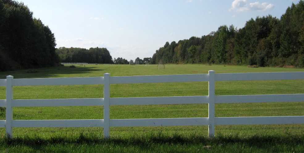
A 2009 photo by Tony Richardson “looking directly down Runway 30, showing the fences & soccer nets.
According to the Master Plan published by Hopewell Township, construction was predicted to be completed by June 2009.”
A 2009 photo by Tony Richardson “inside the small hut near Runway 30's end.
Apparently, this is the hut people would go to for the 'Red Baron' rides. The 'Red Baron' is that red Boeing Stearman in the picture.
In the hut, there were all sorts of old maps, business cards, and pictures of the local area. Sadly, this hut has been torn down as of 2011.”
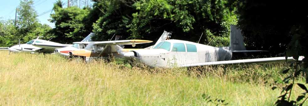
A January 2010 photo of a Cessna 310, Varga Kachina, Cessna, and Mooney which remain stranded in the high grass of the former Twin Pine Airport.
These aircraft deserve a better home.
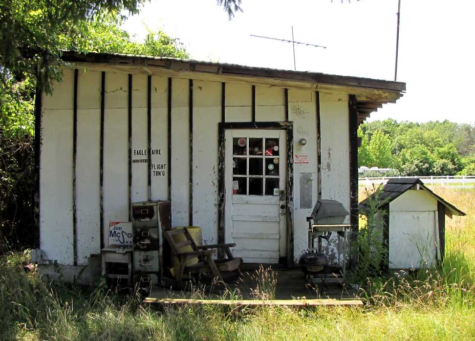
A January 2010 photo of the office of Eagle Aire Flight Training at the site of Twin Pine Airport.
A January 2010 photo looking northeast at the back of the former Twin Pine Airport hangar.

A sad sight – a 9/21/10 aerial view looking east at Twin Pine Airport showed the former runway fenced-off, with soccer goals in the middle,
yet 4 light aircraft remained stranded within a fence around the former hangar.
A 2012 aerial view Tony Richardson looking northeast at the remains of Twin Pine Airport from a Cessna 172.
Tony observed, “The most notable changes are that the entire field has been slightly elevated & the wooded area that was on the left is completely gone, along with the small hut housing lots of aviation memorabilia.”
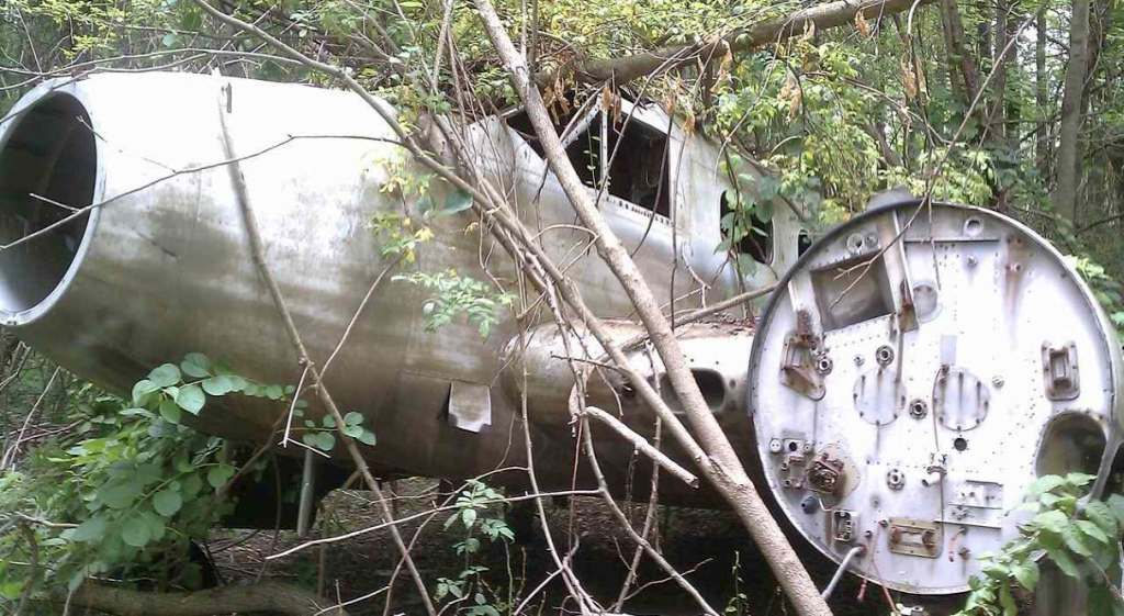
A 2012 photo by Tony Richardson, who observed, “One of the coolest things I found at the airport was this Beech C-45G c/n 51-11481, N7615C, sadly being left to rot in the woods west of the runway.
According to it's registration, it was registered to Engle Flying Service, which was based at the also-abandoned 3M Airport. The plane has been sitting in the same spot since the 1970s.
The thought of getting some R-985s on that plane definitely crossed my mind.
In a conversation I had back in December with former airport owner Mr. Weasner, he explained he still owns it & is asking $1,500 for it.”
Michael Rovello reported in 2015, “The last time I spoke to Jean Weasner she told me that they still had not received all of the money for the airport sale contract.”
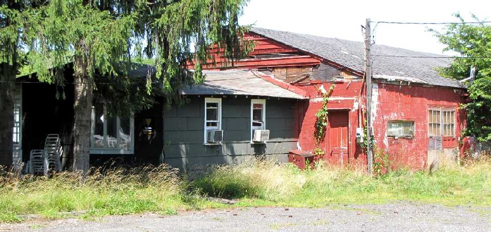
An article in the 8/27/15 nj.com (courtesy of Tony Richardson) described the Twin Pine hangars being removed.
Tony Richardson reported on 1/1/16, “The office (small, white hut in previous photos) had been demolished a year or so ago.
Much to my sadness when I returned, the hangars were indeed demolished with no trace remaining, except for the parking lot.”
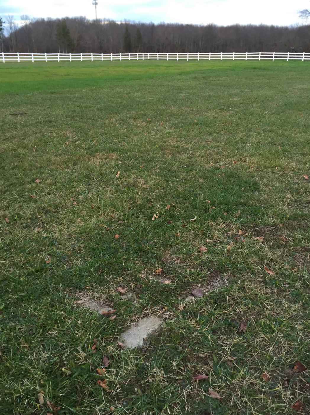
A 1/1/16 photo by Tony Richardson looking North at the site of Twin Pine Airport, showing “some concrete remains in the ground.”
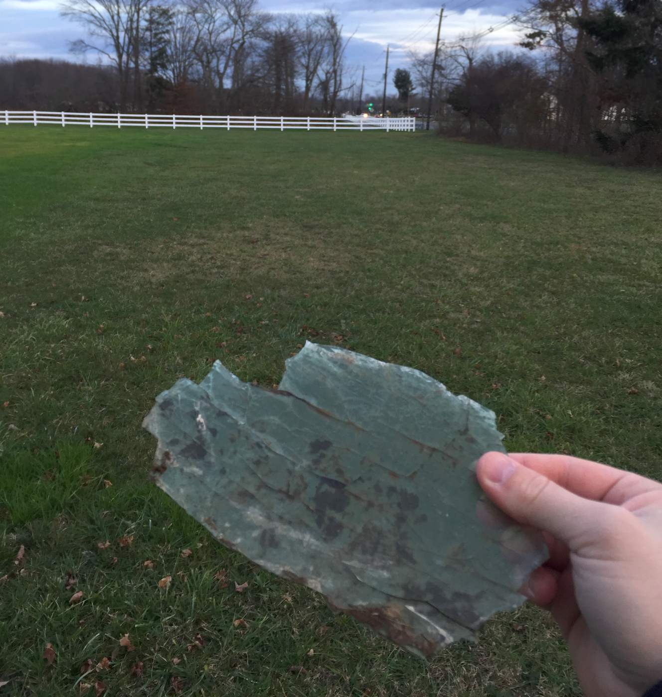
A 1/1/16 photo by Tony Richardson at the site of Twin Pine Airport, showing “a piece of plexiglass found on the property, presumably from one of the stranded aircraft.”
The site of Twin Pine Airport is located northwest of the intersection of Pennington Lawrenceville Road & Federal City Road.
____________________________________________________
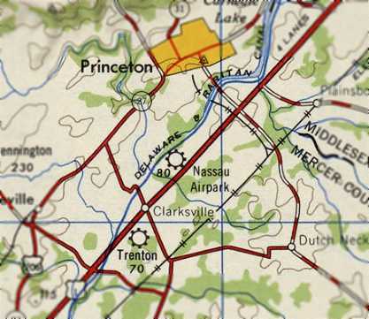
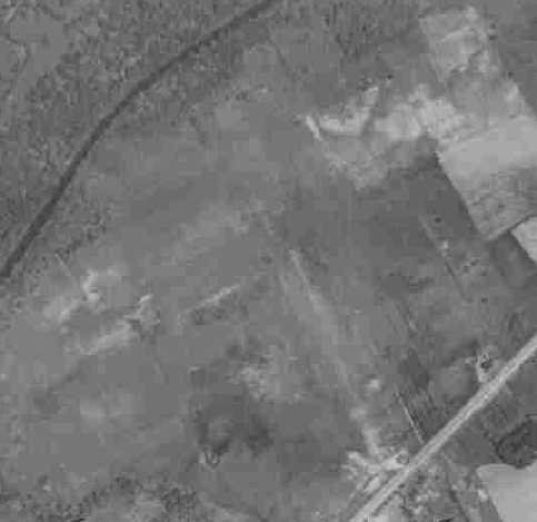
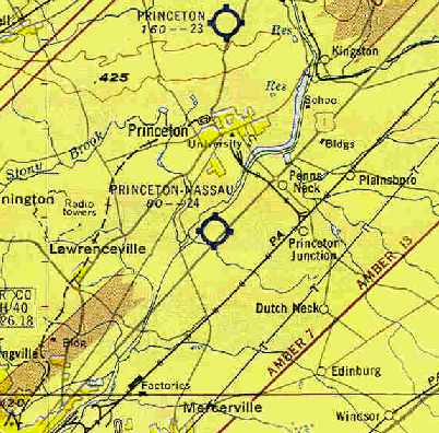
Princeton Nassau Airpark, Princeton, NJ
40.31, -74.67 (Northeast of Philadelphia, PA)
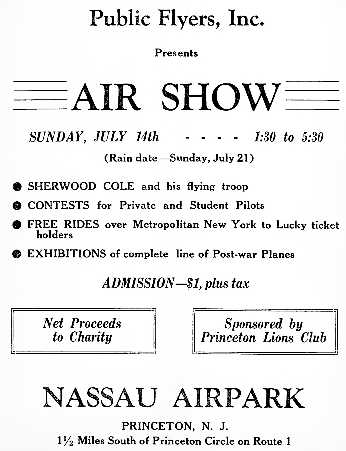
An advertisement for a 7/14/46 air show at Nassau Airpark (courtesy of Mark Hess).
This short-lived little general aviation airport was located on the south side of the town of Princeton.
The Princeton Nassau Airpark was evidently constructed at some point between 1945-46 (like hundreds of other airports in the post-WW2 general aviation boom),
as a 1940 aerial photo did not depict any sign of an airfield
and it was not listed among active airfields in the 1945 AAF Airfield Directory (courtesy of Scott Murdock).
According to Dennis Waters, “In the aviation boom following World War II, an airport was constructed along US-1 in West Windsor, known as the Nassau Airport.
It operated from 1945.
The earliest reference to Nassau Airpark which has been located was an advertisement for a 7/14/46 air show at Nassau Airpark (courtesy of Mark Hess).
The earliest depiction which has been located of the Princeton Nassau Airpark was on the 1947 topo map.
The earliest photo which has been located of Princeton Nassau Airpark was a 1947 aerial photo (admittedly very low-contrast).
It appeared to depict the field as having 2 unpaved runways,
with a single light aircraft just to the east of the runway intersection.
A history of events by Princeton Alumni
reported that “Nassau Airpark” offered half-hour flying lessons for $5 in 1949.
However, Princeton Nassau Airpark was not yet depicted at all on the 1950 NY Sectional Chart (courtesy of Mike Keefe).
Dave Larky recalled, “Nassau Air Park was operated by Thomas Whitfield Savidge & his wife Dorothy.
'Whit' was an instructor & designated examiner & Dottie ran the office.
They had 3 J-3 Cubs when I first met them in March of 1951; later they bought a Piper PA-23 Tri-Pacer.
Whit did the light maintenance - oil changes, etc.
Things were different in those days, and I remember going of on my solo cross-country
in a J-3 with torn fabric in the horizontal stabilizer – holes maybe 3-4 inches across.
There were 2 runways, grass, the longer as 2,100' seems about right.
This longer runway was perpendicular to US Highway 1, on the west side of the highway.”
Dave continued, “Whit & Dottie were the whole outfit – no other instructors, no mechanics, etc.
I think they had their own gas pump because I don’t remember flying to another field to gas up.
Whit was an excellent instructor & it was easy to learn with him.
There were about 5 of us, all working at RCA David Sarnoff Laboratories in Princeton, who started lessons at the same time.
My first lesson was on March 5, 1951. Typical lessons were 30 minutes.
I soloed on April 4 with 8.4 hours, went on my solo cross-country on July 7,
and received my pilot certificate on July 14 with a total of 36 hours 35 minutes.”
Dave continued, “By 1953 several of us owned airplanes.
I bought my first airplane, a Piper PA-20 taildragger N1725A, on December 2, 1953.
The 3-place Super Cruiser shown in the photo belonged to one of my group.
Another one owned a PA-20, and another owned a Culver Cadet.”
A 1953 aerial photo depicted Princeton Nassau Airpark at perhaps the height of its popularity,
with a total of 8 light aircraft visible on the field.
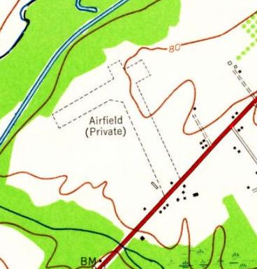
The 1954 USGS topo map depicted Princeton Nassau Airpark as 2 perpendicular unpaved runways,
labeled simply as “Airfield (Private)”.

The earliest aeronautical chart depiction which has been located of the Princeton Nassau Airpark
was on the January 1955 NY Sectional Chart (courtesy of Chris Kennedy).
The Aerodromes table described the field as having 2 runways, with the longest being a 2,400' turf strip.
The July 1955 Philadelphia Local Aeronautical Chart (courtesy of Chris Kennedy)
depicted Princeton Nassau Airpark as having a 2,400' unpaved runway.
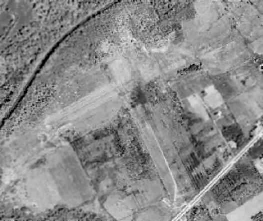
A 1957 aerial photo depicted Princeton Nassau Airpark as having 2 unpaved runways.
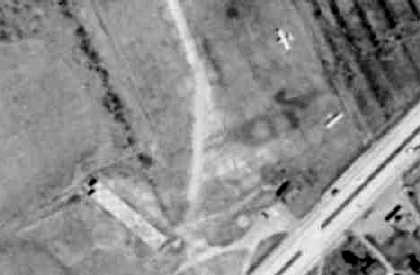
A closeup from the 1957 aerial photo, showing 2 planes at the southern end of the Princeton Nassau Airpark.
Dave Larky recalled, “My last logbook entry for Princeton Nassau Air Park was May 1957.”
The 1957-58 Aviation Week Airport Directory (courtesy of Chris Kennedy)
described Princeton Nassau Airpark as a public-use field,
having 2 unpaved runways: 2,100' north-northwest/south-southeast & 1,900' northeast/southwest.
The field was said to offer storage, minor repairs, fuel, and charter,
and the manager was listed as Thomas Savidge.
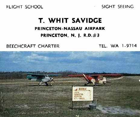
A circa 1957-59 business card for the manager of the Princeton-Nassau Airpark, Whit Savidge (courtesy of Bill Ward, via Tom Kramer),
with a picture of a Piper Super Cruiser & PA-12 on the back side of the card.
The last chart depiction which has been located of the Princeton Nassau Airpark
was on the 1959 NY Sectional Chart (courtesy of Bill Ward, via Tom Kramer).
It depicted the field as having a 2,400' unpaved runway.
According to Bill Ward (who got his private license at Princeton-Nassau Airpark in 1959),
the airport closed in late 1959.
By the time of the 1960 NY Sectional Chart (according to Tom Kramer),
Princeton Nassau Airpark was no longer depicted.
A 1963 aerial photo showed that housing had covered the eastern portion of the former airport,
while the western portions of the 2 former runways were still evident.
By the time of a 1970 aerial photo, a golf course had covered the western portion of the site,
erasing any trace of the former Princeton Nassau Airpark.
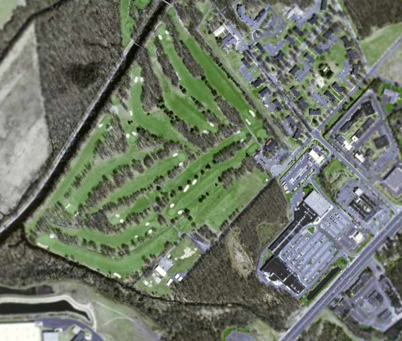
As seen in a circa 20012-2005 USGS aerial photo,
the site of the former Princeton Nassau Airpark has been covered by a golf course & a shopping center,
with no recognizable trace remaining of the former airport.
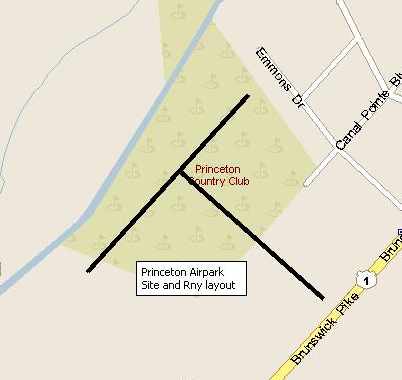
The runway layout of Princeton Nassau Airpark,
superimposed over a circa 2005 street map by Tom Kramer.
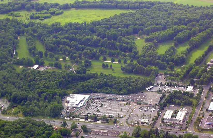
A 2005 aerial photo by Tom Kramer,
looking northwest at the site of the former Princeton Nassau Airpark.
Dennis Waters reported in 2015, “The site is now occupied by the Princeton Country Club.”
The site of Princeton Nassau Airpark is located west of the intersection with of Route 1 & Emmons Drive.
____________________________________________________
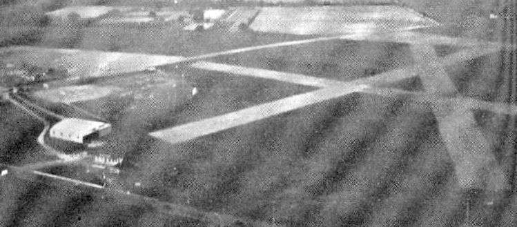
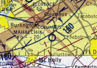
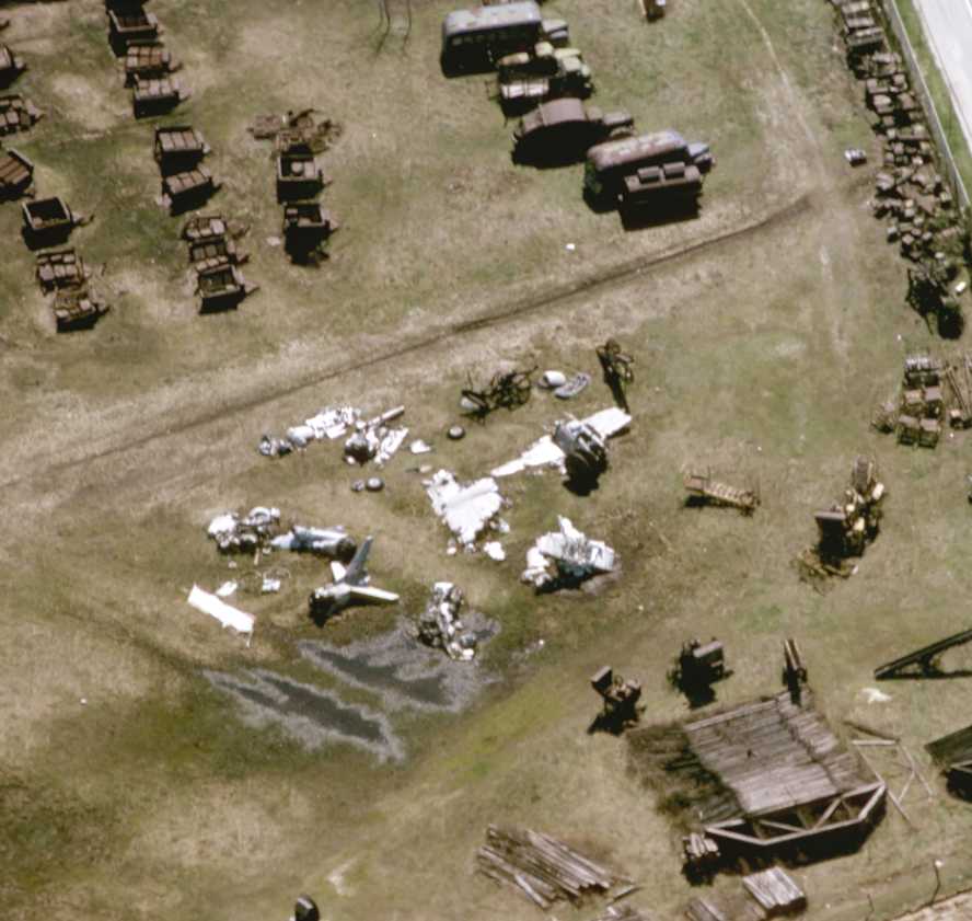
Mahalchik Airfield, Chambers Corners, NJ
40.03, -74.728 (Northeast of Philadelphia, PA)
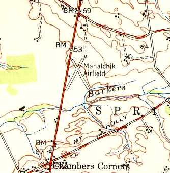
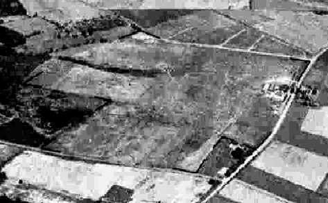
Mahalchik Airfield, as depicted on the 1949 USGS topo map.
Mahalchik Airfield was not yet depicted on a 1940 aerial photo,
nor listed among active airfields in the 1945 AAF Airfield Directory (courtesy of Scott Murdock).
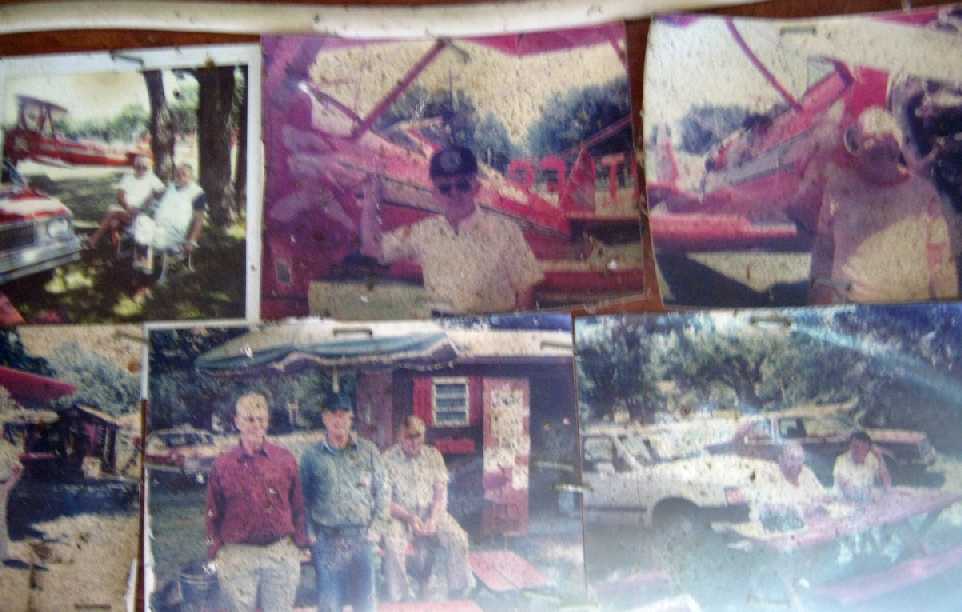
Scott Roberts recalled, “This was a small privately-owned field started after the war [WW2] by John Mahalchik,
who went on to become a county resident of some note.
John Mahalchik was a B17 & B24 instructor pilot during WWII,
and earned the nickname 'Lucky' by being the sole survivor of an aircraft crash, I think it was in South America.
I remember him telling stories about flying there for booze & beef runs!”
According to Doug Wright, “John Mahalchik was a hermit & collector of military junk
who ran for Congress & backed up his convictions with a shotgun.
There is a magazine called 'Weird New Jersey' that did an article about John.”
Mahalchik Airfield was evidently established at some point between 1945-49,
as it was not yet depicted at all on the 1945 NY Sectional Chart.
The earliest depiction which has been located of the Mahalchik Airfield
was on the 1949 USGS topo map.
It depicted the field as having two 1,900' runways, intersecting in an “X” shape.
A single small building was depicted on the west side of the field.
Scott Roberts recalled, “He populated the airport with small military surplus trainers.
Sometime in the late 1940s (I think he said 1949) a hurricane struck NJ,
and most of his aircraft & his hangars were destroyed.
While the airport remained in place,
John Mahalchik came to create a name for himself in the county for his surplus militaria scrapyard -
he collected anything & everything.
One side of the runway was soon bordered by 1940s staff cars,
there were trucks, Navy K-type blimp cars (one of which is now restored & in the National Museum of Naval Aviation)
and even 2 locomotives!”
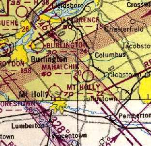
The 1950 NY Sectional Chart (courtesy of Mike Keefe).
depicted Mahalchik as having a 2,000' unpaved runway.
The earliest photo that has been located of the Mahalchick Airfield was a 1953 aerial view.
It depicted the field as having a single northeast/southwest unpaved runway,
with John Mahalchick's scrapyard on the west side of the field.
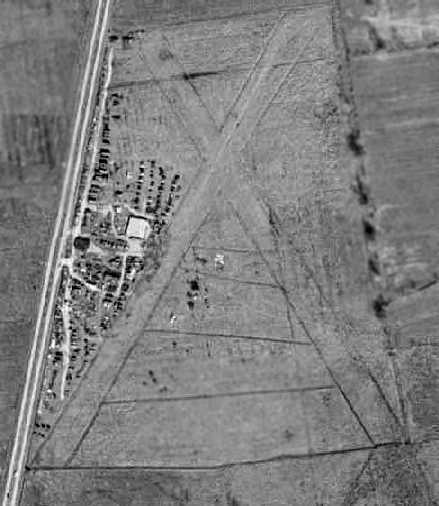
A 1956 aerial view depicted Mahalchick Airfield as having 2 unpaved, very sharply-defined runways,
with the northwest/southeast runway having been added at some point between 1953-56.
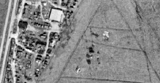
A closeup from the 1956 aerial photo appeared to depict one aircraft, at the bottom-center.
Scott Roberts recalled, “He had a bit of a hard time from the late 1950s, battling with the township & county,
and allegedly the mafia, whom he said burned his house down when he was in jail for taxes one time,
because they wanted his land to build a race track.
I can't corroborate these stories, but that's what he told me!”
According to Doug Wright, “This guy lived inside a jumbo teepee after the locals torched his house.”
Scott Roberts recalled, “When he was in jail
(county, for taxes I believe - although someone paid his taxes every year, anonymously!)
and his house was burned down, he got out, and had nowhere to go.
His wife had left at that point, I think.
So he went to the township, and got a look at building codes, as they refused to let him rebuild his house
(he had all sorts of 'disagreements' with local officials).
Finding what he needed to know, he spent a few days assembling materials,
both from his own stockpile, and the local dump.
At 5 pm that Friday evening he started constructing the 'tin teepee' out old 2x4s & scrap metal.
He finished just before 8 am on the following Monday morning.
The township building inspector showed up almost immediately,
demanding he remove it, because it didn't meet building codes.
Mahalchik then challenged him to show exactly where this building was illegal -
it seems this type structure was completely outside of the written codes, so a legal loophole!
The township corrected this error soon after, but the building, such as it was,
was not subject to it, being preexisting!
John Mahalchik lived there the rest of his life.
I actually was invited in once or twice – as you might expect, it was a true hermit's dwelling.
No interior walls, heat provided by one small woodstove,
whatever rubbish at hand used as fuel, no running water, and only minimal electricity.
While most of the place was in disarray, I do remember quite clearly one piece of artwork -
a framed pencil drawing of a pair of USAF wings about 6 inches across.
Despite all else he was, he was a pilot.”
Scott Roberts recalled, “I do know the field was usable through the 1950s -
a friend of mine, another military aviation nut -
landed there one day, jumped out & asked him (about the surplus he was accumulating),
'This #### for sale?' with a big grin.
Apparently Mahalchik enjoyed his enthusiasm, because he got a good laugh from him.”
The last chart depiction which has been located of the Mahalchik Airfield
was on the January 1958 NY Sectional Chart (courtesy of Chris Kennedy).
It depicted the field as having a 2,000' unpaved runway.
Scott reported, “My friend, Steve Roberts landed there.
He said he landed there in about 1958-59, flying a PA-11 Cub on one of his student pilot cross country flights.
John Mahalchik signed his logbook as having landed.
He said the runways were meticulously maintained at the time,
grass cut well, and clearly identifiable from the air 20 miles away.
He remembers a 'very distinctive' tetrahedron, and the runway markers were beautifully made -
he seems to recall them being cut in half & painted 55 gallon drums.
The rest of the property was in well maintained shape -
with the beginnings of the junk collection in well defined areas, well off the runways.
But no other aircraft seemed to be present.
But it was so beautiful he was compelled to land.
He also remembers the 2 locomotives, and lots of military motorcycles - Harleys, Indians, etc.”
Luther recalled, “My step-grandfather was Andrew Mahalchik, John Mahalchik's father.
I remember we stayed at the junkyard sometime around 1960 for an overnight visit. It was a neat place to be as a kid.
His house was under construction I guess, I remember the floor was not complete. His family was still together at that time.
Uncle John was an Air Force pilot during the Korean war. He was an interesting man & at the same time hard to understand.
I still think about him when I drive down the highway.”
The Mahalchik Airfield was evidently closed at some point between 1958-63,
as it was no longer depicted at all on the January 1963 NY Sectional Chart (according to Chris Kennedy).
A 1963 aerial photo showed that the 2 runways were considerably decayed –
they were no longer the sharply-outlined strips as seen in the 1956 aerial photo.
The Mahalchik Airfield was no longer depicted at all on on the 1969 topo map.
A 1970 aerial photo showed that the large building (hangar?) just west of the runway intersection
had been removed at some point between 1963-70.
The northeast/southwest runway was sharply-defined,
but there was no longer any recognizable outline of the former crosswind runway.
“
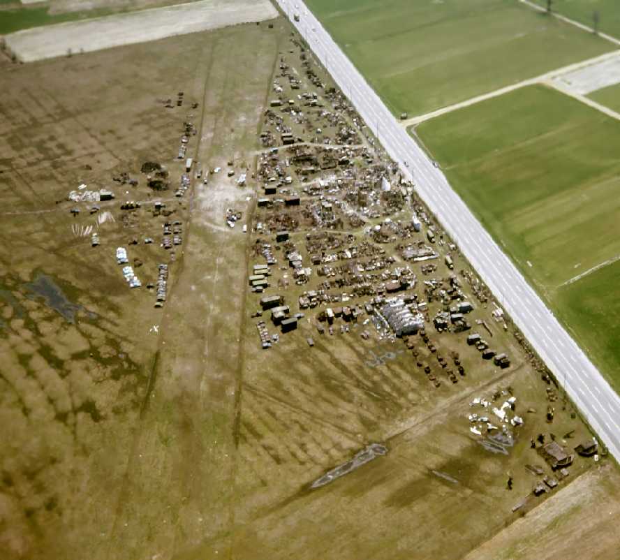
A 1970s aerial view by Rich Kolasa (courtesy of Scott Roberts) looking southeast at Mahalchik Airfield,
showing the 2 grass runways & remains of numerous aircraft, trucks, etc.
Note the infamous “Tin Teepee” midway along the road.
Scott Roberts recalled, “You can see why I loved to hang out there when I was younger!
John Mahalchik was a very guarded person by the time I met him.
He would typically be somewhere on the property, and you'd have to honk to get his attention.
He would come to the front gate, and ask what you were looking for,
and if he thought he had it, he would guide you in, sell it to you, and then guide you out.
If he didn't have what you needed, or if he just plain didn't like you, he'd send you on your way.
I had the privilege of being able to stop by, and once he knew I was there, have free run of the place.
I could wander where ever I liked, and look at whatever stuff I wanted. It was really neat close up, too.”
A 1970s aerial view by Rich Kolasa (courtesy of Scott Roberts) of components of some unidentified jet aircraft.
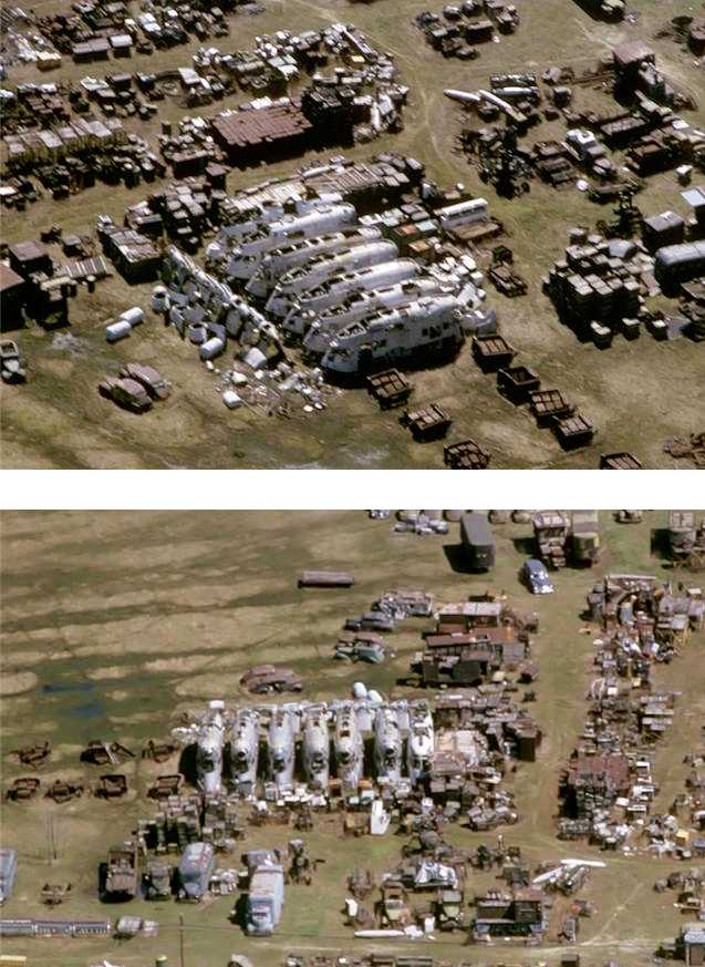
A 1970s aerial view by Rich Kolasa (courtesy of Scott Roberts) of the control cars from 7 WW2-era K-type Navy airships.
However, according to Scott Roberts, “John used to fly his Cessna 150 out of there, long after he stopped being listed as an airport.
For several decades until his passing in the late 1980s this personal scrap drive continued.
Afterwards all he had accumulated was sold off - mostly to recyclers probably,
but a lot of neat things went all over the world - including a CG4A Waco glider.
One thing many people failed to notice when touring the yard during the auction were the little white pyramids,
the remaining markers of the runway.
His airplane was also sold at the auction.”
According to Doug Wright, “The great irony is that his collection of what was considered to be trash
eventually fetched something like $3 million after his death.”
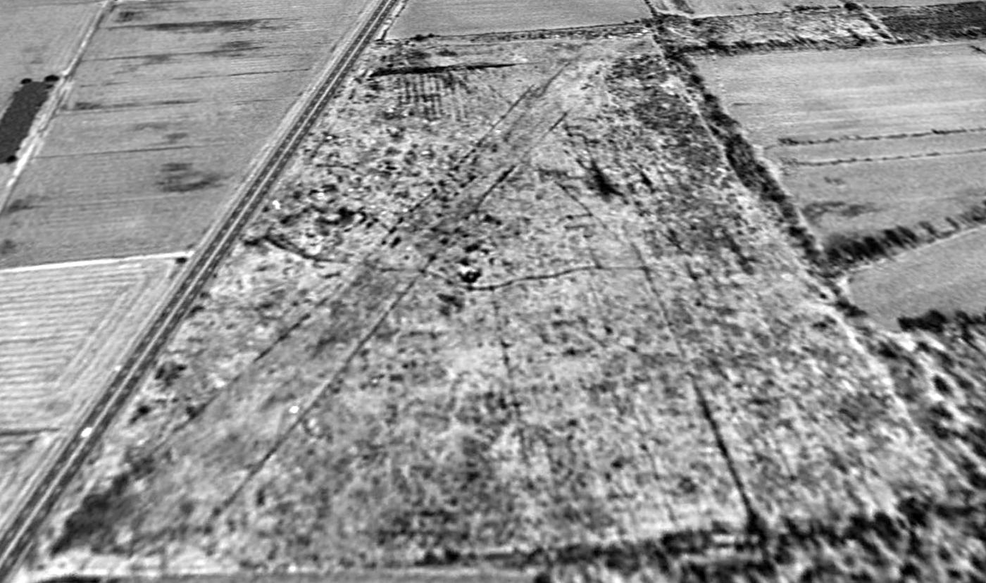
A 1995 USGS aerial view looking north showed the outlines of both former Mahalchik runways were still recognizable.
Scott Roberts observed, “Also noticeable are all the interlocking paths on the property:
for years there was all sorts of machinery, vehicles, etc. piled along them.
Most of it is gone - but the traces still remain.”
Scott Roberts reported in 2005, “The land remains undeveloped.”
An 8/26/08 aerial photo still showed the recognizable outline of the runway.
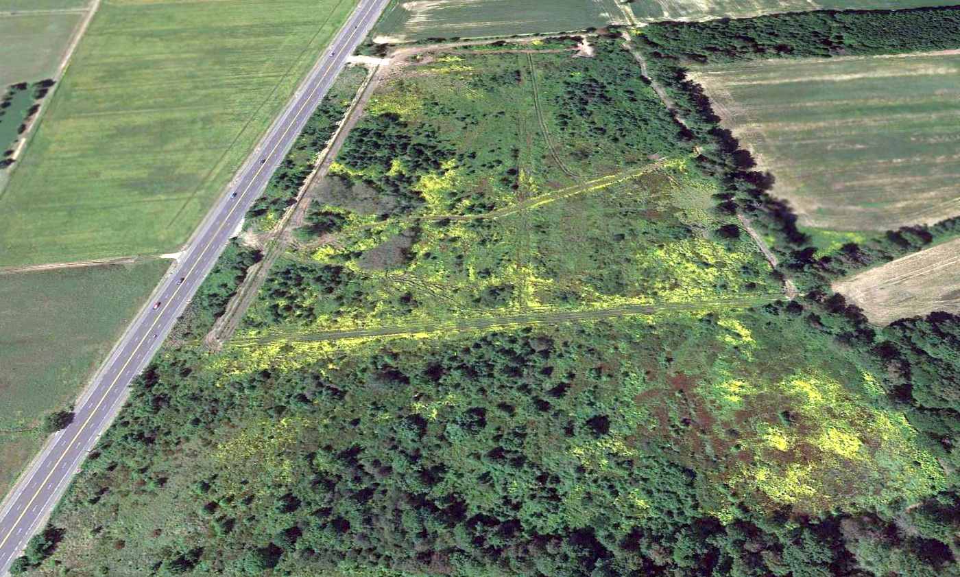
A 2013 aerial view looking north showed several new paths had been carved onto the property, erasing the last traces of Mahalchik Airfield.
Ray Verner reported in 2013, “The land is vacant.
It was recently purchased & fenced using telephone poles as posts, presumably to graze cattle.”
The site of Mahalchik Airfield is located on the east side of Route 206,
north of its intersection with Monmouth Road.
____________________________________________________
Phillipsburg Airport, Phillipsburg, NJ
40.703, -75.153 (West of New York, NY)
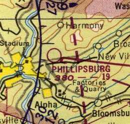
Phillipsburg Airport, as depicted on the January 1950 NY Sectional Chart (courtesy of Mike Keefe).
Phillipsburg Airport, the first airport in Warren County, was founded in 1928 by Walter Lifer
(according to his obituary in the Easton Express newspaper, courtesy of Ron Titus).
Walter “was believed to be the first licensed pilot in Warren County
and made the first airplane delivery of auto parts in April 1928.”
The earliest depiction which has been located of Phillipsburg Municipal Airport
was on the 1930 "Rand McNally Standard Map of New Jersey With Air Trails" (courtesy of Chris Kennedy).
The operator was listed as W. E. Lifer,
and the field was described as being "L"-shaped, measuring 1,500' northeast/southwest x 1,250' north/south.
A 1931 aerial view did not show anything specifically-recognizable as an airfield, just an open grass field.
“The first air meet in Warren County was held at the airport in September 1931
when Army & Navy pilots took part in the show”
(according to his obituary in the Easton Express newspaper, courtesy of Ron Titus).
Phillipsburg Airport may have been temporarily closed during WW2
(due to wartime security concerns,
like many other small civil airports along the coasts during the war),
as it was not depicted at all on the 1945 NY Sectional Chart (courtesy of Norman Freed)
nor listed among active airfields in the 1945 AAF Airfield Directory (courtesy of Scott Murdock).
According to Ron Titus, “In 1946, Ted Phillips bought the Phillipsburg Airport from the Walter Lifer family after it had been closed during WWII.
Phillips took over the airport, renting airplanes & giving flight instruction,
however a series of tragedies would engulf the Phillips family & their airport over the next several years.”
Phillipsburg Airport was not depicted at all on the 1947 USGS topo map.
According to Ron Titus, “In the late 1940s a nor'easter storm wreaked havoc on the Phillipsburg Airport
causing extensive damage to the hangars, buildings, and aircraft.
The storm lasted for 2-3 days as remembered by Catherine Wilhelm, a pilot at the airport at the time.”
Phillipsburg Airport was depicted on the 1949 NY Sectional Chart (according to Chris Kennedy)
as having a 1,900' unpaved runway.
An article in the 9/9/51 issue of the Easton Express (courtesy of Ron Titus)
was titled “Pilot, 4 passengers die as plane crashes, burns at Phillpsburg Airport.”
It described how a pleasure flight from Phillpsburg Airport killed all 5 occupants,
including Terry Phillips, the daughter of the airport owner.
According to Ron Titus, “Tragedy would again strike the Phillips family when Ted Phillips, owner of the airport,
would perish in yet another aircraft accident just 2 years after his daughter Terry perished.”
An article in the 6/22/54 issue of the Easton Express (courtesy of Ron Titus)
was titled “Plane crash kills two.”
Ron Titus recalled, “In 1955 there was a bad flood of the Delaware River between Phillipsburg & our sister city in Easton PA.
All the bridges were knocked out.
The Phillipsburg Airport was used as a staging area to fly people & supplies back and forth to Braden's airport in Easton.”
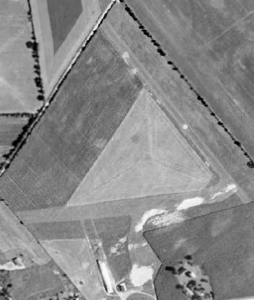
The only photo that has been located showing the Phillipsburg Airport while it was open was a 1956 aerial view.
It depicted the field as having 2 grass runways,
with 2 buildings (hangars?) on the south side of the field.
There were not any aircraft visible on the field.
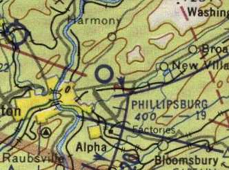
Phillipsburg Airport, as depicted on the July 1957 NY Sectional Chart (courtesy of Mike Keefe).
The 1958 NY Sectional Chart (courtesy of Norman Freed)
described Phillipsburg as having 2 runways, with the longest being a 1,900' dirt & turf strip.
Ron Titus recalled, “I remember it as a 12 year old Civil Air Patrol cadet back in 1958.
We stored our old L-4 there then.
Our Commanding Officer of the Phillipsburg unit back then was Captain Ed Martino.
There wasn't much there at that time.
There was the Airport Bar & Hotel & a small cement block building out on Route 57.
The road that went behind it, Strikers Road, had some old wooden T-hangars on it.”
According to Ron Titus, “The Phillipsburg Airport would continue to operate a few more years after the death of Ted Phillips.
His sister Leona Phillips Noto would operate the field until legal costs associated with the local government's condemnation proceedings
would force her to close it in the late 1950s after a 10-year battle to keep the property.
The John Vitaly family operated the Airport Inn restaurant until it also was forced to close.”
Phillipsburg Airport was apparently closed at some point between 1958-60,
as it was not depicted at all on the 1960 NY Sectional Chart (courtesy of Mike Keefe).
In a 1996 report by the New Jersey General Aviation Study Commission's Subcommittee on Airport Closings,
reasons were given for the closing of 13 New Jersey general aviation airports.
According to the report, Phillipsburg Airport was closed after 10 years of litigation with a township school board,
which wanted to build a school on the airport land.
The courts ruled the township had the right to condemn the land & build a school.
Ron Titus recalled, “The Township that closed it up with condemnation was Lopatcong Township.
They wanted it for an elementary school.
There were 2 large farms in the mist of being sold for a major development back then
and the airport land would be right in the middle off to the side.
No one knew that though, back then, when it was being grabbed up.
It was indeed the end of an era for aviation in Phillipsburg when this property was finally siezed.”
A 1963 aerial view no longer showed any sign of the runways,
and the hangars had been removed, with construction proceeding for the school
which would be built on the southern portion of the former airport property.

The 1981 USGS topo map still labeled the outline of the Phillipsburg Airport,
even though the airport had been closed for over 20 years by that point,
and it also depicted the school which had been built over the site.
Phillipsburg Airport was still depicted on the 1994 USGS topo map.
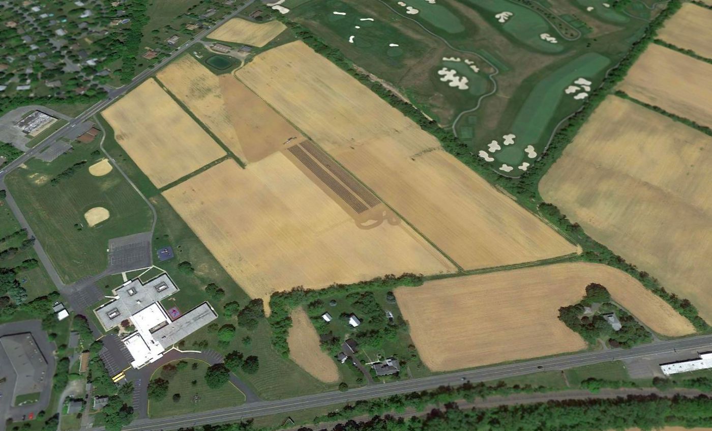
A 2012 aerial view looking north showed the property outline was the last recognizable trace of Phillipsburg Airport.
The site of Phillipsburg Airport is located northeast of the intersection of Routes 22 & 57.
Thanks to James G. for pointing out this airfield.
____________________________________________________
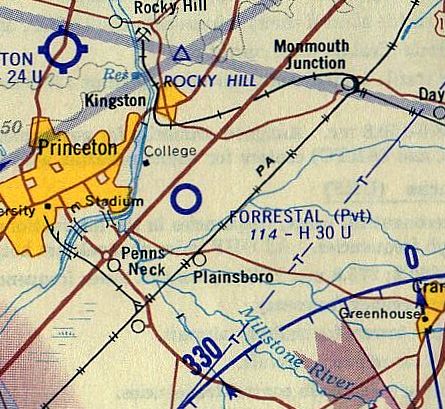
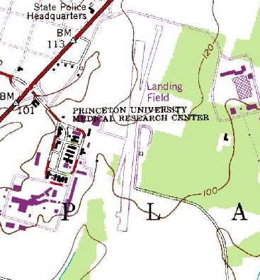
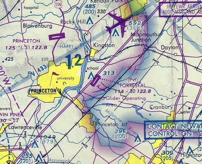
Forrestal Airport (N21), Princeton, NJ
40.348, -74.61 (Southwest of New York, NY)
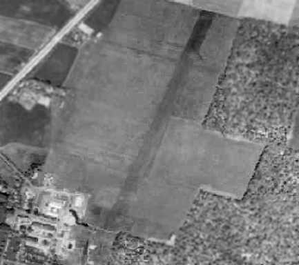
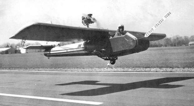
A 1956 aerial view depicted Forrestal Airport as having a single unpaved northeast/southwest runway.
This small airport was operated by Princeton University for aeronautical research.
It was located along the east side of Route 1, two miles east of Princeton University.
Dan Sayre, a mechanical engineer at the University who started the aeronautical engineering department in 1942,
and Cortland Perkins, an aeronautical instructor who later became chairman of the department,
convinced the University to acquire the property on the east side of Route 1 in 1950.
Barry Nixon came to the Princeton University aeronautical engineering department in search of a master's degree in 1952,
just as the facility at the Forrestal Research Center was being put together.
When he began working for his master's degree in 1952,
not only did Barry Nixon have to take classes & attend lectures,
he had to help convert greenhouses into hangars & build the quarter-mile long airstrip.
A 1953 aerial view did not depict any recognizable signs of a runway.
A 1956 aerial view depicted Forrestal as having a single northeast/southwest grass runway,
with a single light plane parked outside a hangar on the southwest side.
A 1957 aerial view depicted Forrestal in basically the same manner.
After a stint in the Navy, Barry Nixon came back to Forrestal in 1959
and resumed working at the research center as both an instructor & flight researcher.
By then, "things were really humming," he said.
For the next 25 years, he worked in flight research on airplanes,
helicopters, gliders, blimps, balloons, windmills & even model birds,
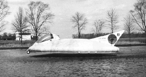
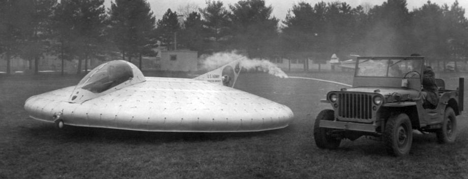
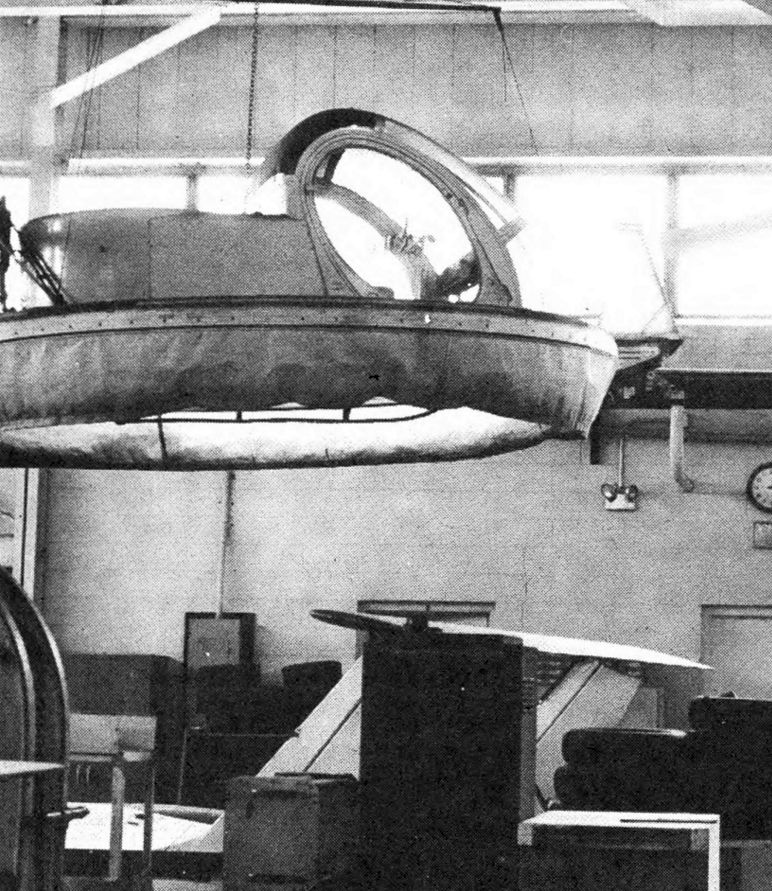
but perhaps most impressive were the ground effect machines, or hovercraft.
Nixon worked under Tom Sweeney & Ed Seckel, both instructors in the aeronautical department.
Sweeney was his immediate boss at the flight laboratory & was the creative mind behind the ground-effect machines.
The size & range of uses for these machines varied widely.
The laboratory created several ride-on air scooters that hovered a few feet from the ground,
and even an air version of the wheelbarrow.
The Airbarrow - an 8' x 4' ground-effect machine - was built in the mid-1960s & designed with a 5 hp engine
to be pushed & carry small cargo on construction sites.
They also built the AG-GEM, a medium-sized, 43 hp hovercraft
that was flown in the mid-1960s to test the concept of spraying crops.
It was taken to Toms River & used successfully on a cranberry bog, Nixon said.
The AG-GEM was last flown in the 1970s
and was on display at the New Jersey Aviation Hall of Fame in Teterboro
until it was left outside & destroyed by the weather, he said.
But the largest ground-effect machine built was the P-GEM,
a 20' diameter circular hovercraft with a 180 hp lift engine & 43 hp tail engine.
The third generation of this machine was built in the early 1960s
and even got the distinguished opportunity of being escorted down Route 1 by police.
"Route 1 was quite a challenge.
Cars were pulled over to the side & there was only a couple feet of clearance,
but it never hit anything," Nixon said.
The P-GEM was last flown in the 1980s & has since been bulldozed & discarded by the University, he said.
Forrestal was not yet depicted on the 1961 Philadelphia Local Aeronautical Chart (courtesy of Mike Keefe).
The earliest directory listing which has been located of Forrestal Airport
was in the 1962 AOPA Airport Directory.
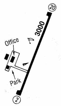
It described Forrestal as having a single 3,000' blacktop Runway 4/22,
and the operator was listed as "Engineering Department, Forrestal Research Center".
It included the note, "Caution: Closed to the public."
Forrestal Airport was still not depicted on the 1963 Philadelphia Local Aeronautical Chart (courtesy of Mike Keefe),
which is odd, even for a private airfield.
A 1963 aerial view showed that Forrestal had gained a paved runway at some point between 1957-63.
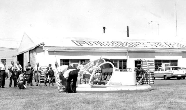
A circa 1965-68 photo of the 12' Princeton AgGem hovercraft,
seen in front of the old Forrestal hangar (courtesy of Albert Newton, via Steve Sweeney).
The craftsman most responsible for the construction of the AgGem was Albert Newton.
The AgGem evidently reused the cockpit bubble from a Hughes 300 helicopter.
A significant amount of material about Forrestal was sent in by Steve Sweeney,
whose father worked at the hangar at Forrestal for many years,
and who was privileged as a child to spend most of his Saturdays with him there.
In Steve's words, "Forrestal was a really neat place.
Most of Princeton's engineering schools were located there,
including 2 active flight test laboratories, Flight Dynamics & Advanced Flight Concepts."
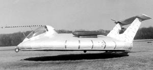
An undated view of the Princeton P-GEM hovercraft.
An undated view of the Princeton P-GEM hovercraft.
An undated photo of the Princeton 20' P-GEM hovercraft,
flying over over a pond at Walker-Gordon farms, adjacent to Forrestal (courtesy of Albert Newton, via Steve Sweeney).
They simply flew it over there for over water trials.
Unfortunately, both the AgGEM & the PGEM were lost to the scrapper.
An undated photo of the Princeton 20' P-GEM hovercraft at Forrestal, with a Piper Tri-Pacer visible behind the Jeep.
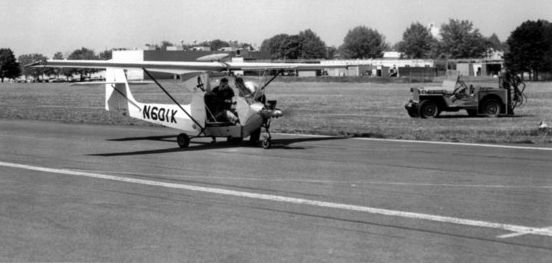
An undated photo of N601K, a very unusual experimental aircraft on the Forrestal runway.

A circa early 1960s photo of the smaller single seat "Airscooter" hovercraft (courtesy of Albert Newton, via Steve Sweeney).
This machine was scrapped at Princeton,
however an older sister machine survives today at the American Helicopter Museum in Brandywine, PA.
Additionally, a 3rd similar airframe belongs to the Smithsonian.
Sweeney continues, "There was considerable work done with Ground Effect Machines [hovercraft],
from about 1958-70, I believe.
This research, both theoretical & applied, resulted in four man carrying machines, built at Princeton.
The largest of these, circular machines, at 20' in diameter, did fly on US Route 1,
in order to travel to a local farm for trials over potatoes.
This was to see how crops would react to the intimate nature of an air cushion vehicle."
A circa early 1960s photo of the variable-stability Princeton Navion
on the taxiway at Forrestal (courtesy of Albert Newton, via Steve Sweeney).
Keith Caulton recalled, “My dad took me to the Forrestal Airport mostly to look at the hovercraft.
Later our Trenton Chapter of EAA visited Forrestal, and the variable stability Navion had numerous internal & external changes
that apparently took place after the photograph [above].
We were also privileged to see an ornithopter powered by compressed air on that visit.”
Steve Sweeney recalled, "The aeronautical engineering department owned several aircraft over the years.
In addition, there were other aircraft that were loaned, or sent to Princeton for evaluation.
At the end of the laboratories life there were 4 airplanes.
There were 2 Ryan Navions, one was extensively modified as a variable stability aircraft,
the other was stock, used for pilot proficiency.
The blue ship was the Variable Stability Navion.”
Sweeney continues, "Lastly there was a Lockheed LASA.
That LASA was one of 2 airframes designed & built by Lockheed for construction abroad.
The LASA was donated to Princeton, after Lockheed was done with it."
The LASA 60, short for Lockheed-Azcarate & the year of completion,
was a utility plane built for the Mexican market.
Two were built by Lockheed in Georgia, and small numbers were eventually produced in Mexico & Italy.
Steve continues, "There were several other aircraft,
and other interesting machines that were either built at Princeton, or wound up there over the years."
"Forrestal Airport, and the entire Forrestal Campus was very much alive & hitting it's stride during the 1960's.
It was with the early demise of the Apollo program that ended most of the research at Forrestal,
and directly impacted the work at the hangar.
I would say that active flight testing was about over with by the late 1970's."
"It was a rare day when there were no visitors on the flight line.
Beavers, Cubs, Luscomes, Yankees, T-34's, a Porter & assorted Turbo Porters, Helio Couriers, Mohawks,
Hueys, JetRangers, 47's, Hillers, Hughes 300 & 500's, a twin Navion, a twin Bonanza,
assorted Cessnas including the then new Citation demonstrator, Pipers & Beechcrafts including King Airs,
Grumman S2's, an Albatross, a touch & go by a Navy blimp, and a Lake Amphibian."
"The original hangar was replaced with a new building in 1968, I believe.
The old hangar was then used as a garage for the motor pool.
So, there was only one active hangar."
An undated photo of the Goodyear Inflatoplane, tested at Forrestal (courtesy of Albert Newton).
Former Forrestal Lab employee Albert Newton relates the story
of another unusual aircraft tested at Forrestal - the Goodyear Inflatoplane.
The Army & Navy had several of them built in the 1950's.
Their fuselage & wings were inflatable, made of a material similar to what Goodyear
used to construct their blimps, rubber impregnated fabric, probably Dacron.
It was inflated to about 5-7 PSI to make it semi-rigid.
When it is deflated, it was folded up & stuffed into a 5 sq-ft. box.
The only rigid parts were the engine & pedestal & landing gear assembly.
They were intended to be parachuted down to a stranded pilot that had been shot down behind enemy lines.
The pilot was supposed to pull it out of the box, inflate it with a small air compressor (also in the box),
start the engine (hand crank), get into the cockpit & fly back home.
Newton says, "The airplanes did fly, but it was not easy to get it started & airborne.
The Army did some flight tests but they had some fatalities & abandoned the whole idea.
In the early 1960's, Tom Sweeny got the idea to try to get one of these planes
and do some flight testing on it at Forrestal.
There was never any real documented information obtained on their flight characteristics
and it would be worthwhile for student research."
"There were three Navy pilots here that were doing the flight testing
and I installed the test equipment & maintained the aircraft & cranked the engine.
It was difficult to attach things because it was flexible.
Some items had to be mounted on the landing gear structure.
Other sensors had to be fastened with duct tape.
At the speeds we were flying at, It held up pretty well.
After several months, the testing was more or less completed.
One of the test installations was a 16mm movie camera mounted on a outrigger.
When our Department Chairman saw the film of the fuselage bending & twisting,
he said "Stop flying this airplane & get it out of here."
We deflated it & put it back in the box & shipped it to Goodyear to put in their museum.
I believe it still exists & is kept inflated."
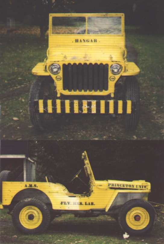
An undated photo (courtesy of Jeffrey Hoch) of a Jeep previously used as Forrestal Airport.
For 25 years, Barry Nixon worked for Princeton University's aeronautical engineering department in flight research,
testing many kinds of experimental flight vehicles.
Among them were ground-effect machines, commonly known as hovercraft.
Many of these machines looked like they could have come from outer space.
In the late 1950s & early 1960s, they often stopped traffic
while being tested at the University's flight research facility at the Forrestal Research Center.
Since the test area was only about 50 yards from Route 1,
"you could often hear brakes squealing," Mr. Nixon said,
"and people would stop to see what was going on.
I think some actually thought they saw a UFO descending on the airfield."
The earliest chart depiction of Forrestal Airport which has been located
was on the 1964 NY Local Aeronautical Chart (courtesy of John De Nicola).
It depicted Forrestal as a private field with a 3,000' paved runway.
A 1969 aerial view depicted a single light aircraft parked near the hangar.
A 1972 aerial view depicted Forrestal as having a single paved Runway 2/20.
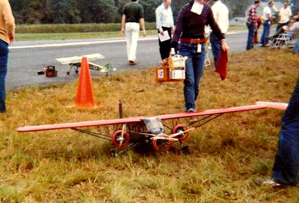
A 1977 photo by Jim Hann of radio-controlled model aircraft being operated from the runway at Forrestal.
Jim recalled, “I didn't take any of the hangars or tetrahedron or the glider I remember being there.”
A 1979 aerial view showed that at some point between 1972-79,
Forrestal's Runway 3/21 was replaced by a new Runway 2/20, which was also located somewhat father south.
The reason for the runway replacement has not been determined,
as both runways were the same length – 3,000'.
The 1979 NY TCA chart (courtesy of Bill Suffa) depicted Forrestal as having a single 3,000' paved northeast/southwest runway.
Nearby resident Douglas Wright indicates that the
airfield was used by a local soaring club in the late 1970s,
apparently with permission of the Forrestal center.
On the 1981 USGS topo map,
the runway was still depicted, but was simply labeled "Landing Strip".
The airfield was depicted as having a 3,600' runway,
taxiways, a ramp, and 2 small hangars west of the runway.
An undated photo from the 2/26/81 The Daily Princetonian (courtesy of Jeffrey Hoch) of the interior of the Forrestal hangar,
showing the Princeton AgGem hovercraft hanging from the ceiling, and what appears to be the tails of the P-GEM hovercraft at the bottom.
The 1982 AOPA Airport Directory (courtesy of Ed Drury)
described Forrestal as having a single 3,000' asphalt Runway 3/20.
The last aeronautical chart depiction which has been located of Forrestal Airport
was on the June 1982 NY Terminal Aeronautical Chart (courtesy of Mitchell Hymowitz).
It depicted Forrestal as a private airfield with a 3,000' paved runway.
The 1983 Flight Guide (courtesy of Chris Kennedy)
depicted Forrestal as having a single 3,000' paved Runway 2/20,
and a ramp on the west side containing an office & 2 other buildings (hangars?).
The remarks said: "Caution: Autos, gliders, balloons. Prior permission required.
Limited to university business only."
The University disbanded the flight laboratory in 1983.
Jim Hann recalled returning to Forrestal in 1983 for a radio-controlled model aircraft competition.
“The runway was still in really good shape, as it had to be for the models.
I remember walking across the runway and into the woods at least once to help a fellow competitor retrieve his wreckage.
I'm not sure if the glider was still there that time, I was focused on competing!”
A circa 1980s aerial view looking southwest at Forrestal Airport by Philip Kineyko.
Erik Mann recalled, “I arrived as an undergraduate student in 1984,
and by that time most (if not all) of the flight research had been suspended.
There were still projects going on in the hangar, including various ultralights,
some automobiles, and assorted other modes of transport.
But, the Navions & a couple of other aircraft were in mothballs.”
The last photo which has been located showing Forrestal Airport was a 1986 aerial view.
The runway was still intact, and a single light aircraft was parked near the hangar.
The outline of the former Runway (on a slightly different alignment, 3/21) was still perceptible.
Steve Sweeney pointed out: “To the left of Runway 2 is a long narrow building. That is the Princeton Long Track.
An inverse wind tunnel, where the model rode on a sled suspended by a fixture riding on a track. Very interesting & unique.
Just to the left of the long track near the top of the building are 2 small parallel roofs, also parallel with the long track. Those were wind tunnels.”
Erik Mann recalled, “The airport was active as a glider operation through 1988 & into 1989.
The Soaring Society of Princeton University operated 3 gliders & a Piper Supercub towplane.
At one point, there were more than 70 members in the club.
On a good weekend, we would have about 40-50 takeoffs & landings,
with some additional activity on weekdays, including launches behind an old Buick station wagon.
But, by 1988, the handwriting was on the wall,
as the University saw the value of land along Route 1 going through the roof,
and there wasn't much justification for a $10 million gliderport.
So, the club moved from Forrestal (I think it was in early summer of 1989) to Van Sant airport in Bucks County.”
The date of closure of the Forrestal Airport is unknown.
Erik Mann recalled, “About half of the runway was still around in the early 1990s (we flew a touch & go in a J3 for nostalgia's sake).”
By the time of the 1995 USGS aerial photo, the 2 hangars still remained standing,
but the runway & taxiway pavement had been removed,
with an open field in their place.
Erik Mann recalled, “The last time I overflew it in 2000, it looked like most of the pavement was gone.”
The airfield was no longer depicted at all (even as an abandoned airfield) on recent aeronautical charts.
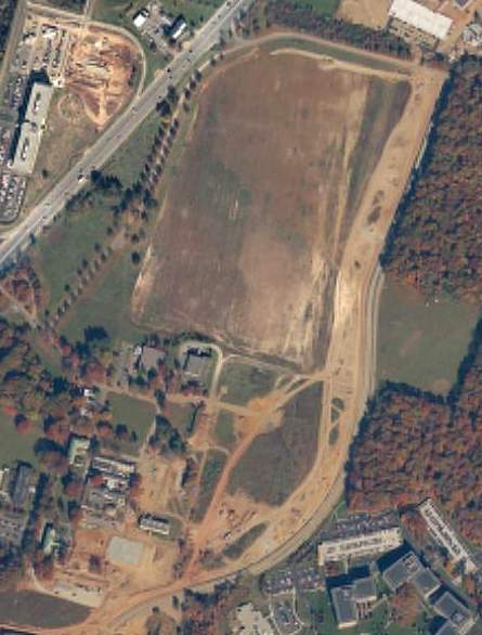
In the circa 2001 aerial photo, the runway & taxiway had been removed, but the hangar still existed.
The property is now used as the Rockefeller Medical Research Center.
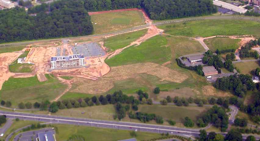
A 2005 aerial photo by Tom Kramer, looking southeast at the site of Forrestal Airport.
Tom observed, “To the middle right, the hangar is still there but now a building under construction occupies where the runway used to be.”
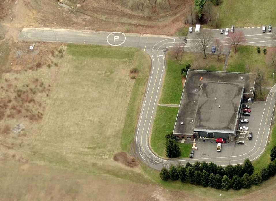
A circa 2007 aerial view looking south at the aviation remnants at the site of Forrestal Airport:
a building has a red windsock on top, and a portion of the former taxiway with a private helipad marking.
Thanks to Tom for pointing out this field.
See also:
www.pacpubserver.com/new/news/7-13-01/saucers.html
"Princeton's James Forrestal Campus: Fifty Years of Sponsored Research", Princeton University.
____________________________________________________
Since this site was first put on the web in 1999, its popularity has grown tremendously.
That has caused it to often exceed bandwidth limitations
set by the company which I pay to host it on the web.
If the total quantity of material on this site is to continue to grow,
it will require ever-increasing funding to pay its expenses.
Therefore, I request financial contributions from site visitors,
to help defray the increasing costs of the site
and ensure that it continues to be available & to grow.
What would you pay for a good aviation magazine, or a good aviation book?
Please consider a donation of an equivalent amount, at the least.
This site is not supported by commercial advertising –
it is purely supported by donations.
If you enjoy the site, and would like to make a financial contribution,
you
may use a credit card via
![]() ,
using one of 2 methods:
,
using one of 2 methods:
To make a one-time donation of an amount of your choice:
Or you can sign up for a $10 monthly subscription to help support the site on an ongoing basis:
Or if you prefer to contact me directly concerning a contribution (for a mailing address to send a check),
please contact me at: paulandterryfreeman@gmail.com
If you enjoy this web site, please support it with a financial contribution.
please contact me at: paulandterryfreeman@gmail.com
If you enjoy this web site, please support it with a financial contribution.
____________________________________________________
This site covers airfields in all 50 states.
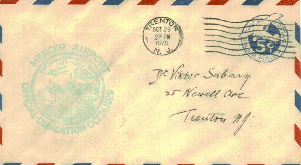