Abandoned & Little-Known Airfields:
Southwestern New Jersey
© 2002, © 2015 by Paul Freeman. Revised 11/5/16.
This site covers airfields in all 50 states: Click here for the site's main menu.
____________________________________________________
Please consider a financial contribution to support the continued growth & operation of this site.
Aero-Haven / Camden Burlington County (revised 7/11/15) - Almonesson Airport (revised 6/11/13) - Bridgeport Airport (revised 11/5/16)
Cavoli's Airport (revised 11/5/16) - Marlton-Medford Airport (revised 7/4/14) - Pitman Airport (revised 8/8/15)
____________________________________________________
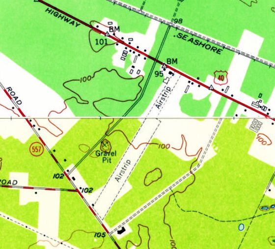
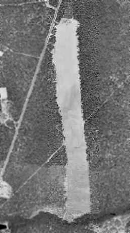
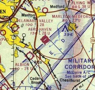
Marlton-Medford Airport, Marlton, NJ
39.9, -74.9 (East of Philadelphia, PA)
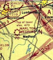
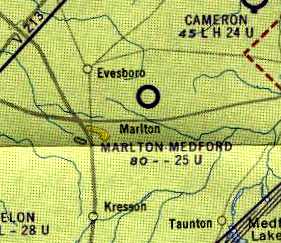
Marlton-Medford Airport, as depicted on the 1946 Washington Sectional Chart (courtesy of Mike Keefe).
This little general aviation airport was evidently established at some point between 1945-46,
as it was not yet depicted on a 1940 aerial photo
nor listed among active airfields in the 1945 AAF Airfield Directory (courtesy of Scott Murdock).
The earliest depiction of Marlton-Medford Airport which has been located
was on the 1946 Washington Sectional Chart (courtesy of Mike Keefe),
which depicted it as a commercial/municipal airport.
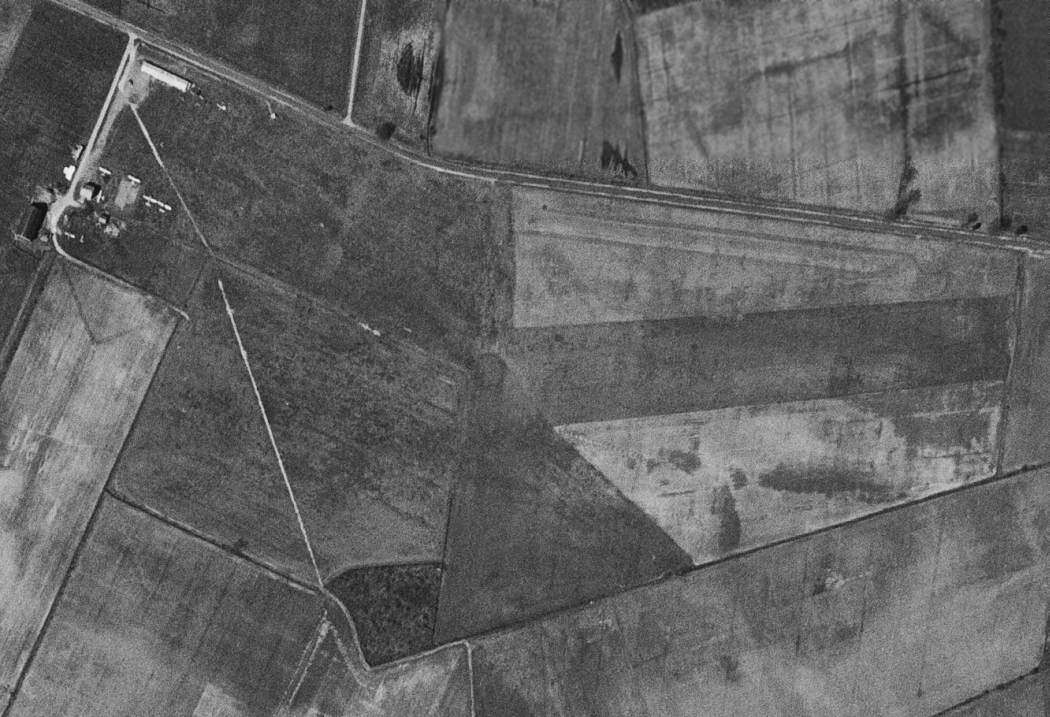
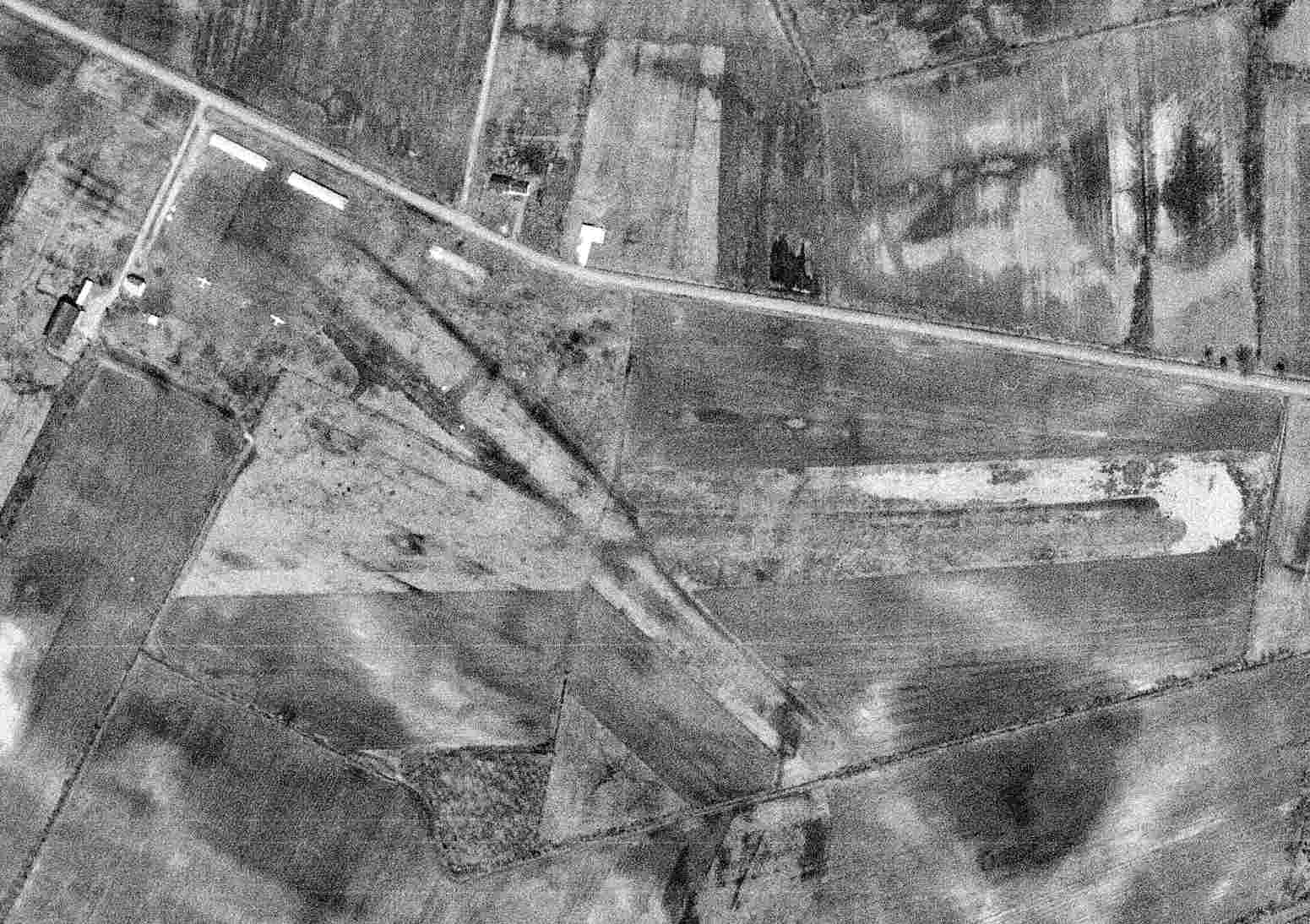
The earliest photo of Marlton-Medford Airport which has been located was a 4/20/51 USGS aerial view.
It depicted the field as having 2 grass runways, with a few small hangars & 5 single-engine aircraft at the northwest corner.
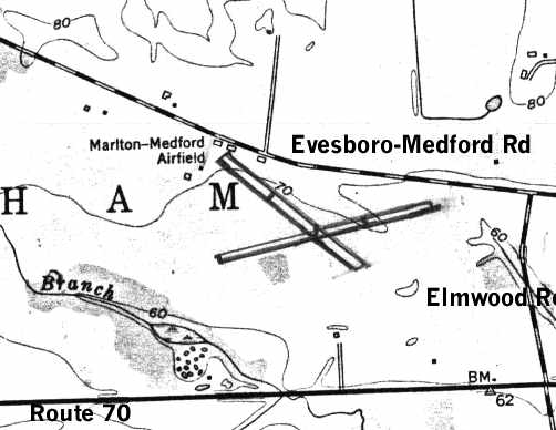
The 2 runways of the Marlton-Medford were drawn in on the 1953 USGS topo map (courtesy of Pete Greene).
Each of the runways was depicted as having a parallel taxiway,
and several airport buildings were depicted along Evesboro-Medford Road.
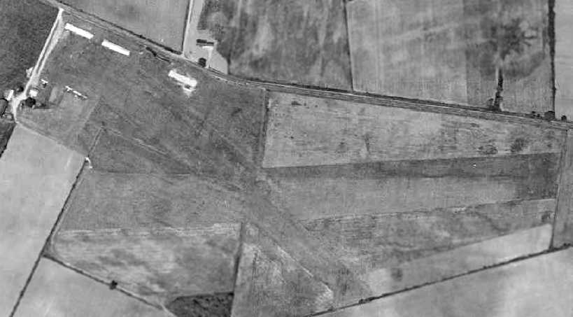
A 1956 aerial view depicted Marlton-Medford Airport as having 2 grass runways, with a few small hangars & 4 single-engine aircraft at the northwest corner.
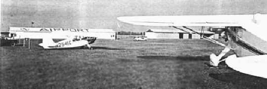
An undated view of 3 taildraggers in front of 2 hangars at the Martlton-Medford Airport (courtesy of Pete Greene).
The 1961 Philadelphia Local Aeronautical Chart (courtesy of Mike Keefe)
depicted Marlton-Medford as having a 2,500' unpaved runway.
The 1962 AOPA Airport Directory described Marlton-Medford Airport as having 2 turf runways:
2,500' Runway 9/27 & 2,250' Runway 13/31.
The field was described as offering fuel, hangars, and tiedowns,
and the operator was listed as Airport Associates Inc.
The 1964 Washington Sectional Chart depicted Marlton-Medford as having a 2,300' unpaved runway.
The last photo of Marlton-Medford Airport which has been located was a 4/1/65 USGS aerial view.
It depicted the field as having 2 grass runways, with a few small hangars & 2 single-engine aircraft at the northwest corner.
Marlton-Medford Airport was evidently closed (for reasons unknown) at some point between 1965-67,
as it was no longer listed among active airfields in the 1967 AOPA Airport Directory (according to Chris Kennedy).
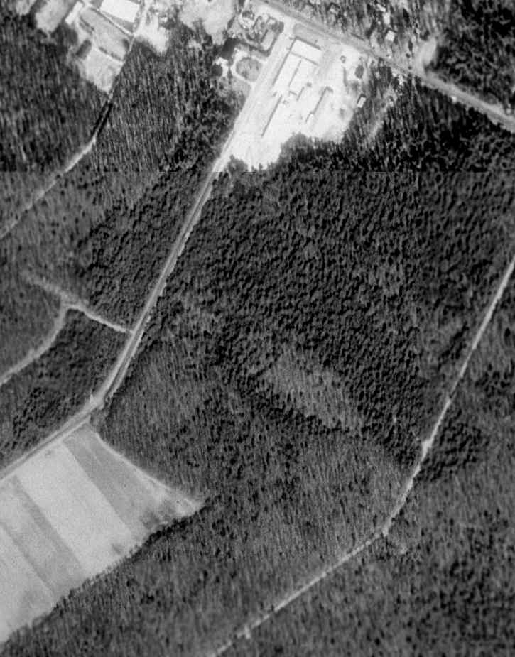
A 1970 aerial photo showed that streets for a new residential development had covered the site,
with not a trace left of the former airport.
Pete Greene reported in 2004, "My house is located near what used to be the Operations building
of the old Evesboro Airport [Marlton-Medford Airport].
When I moved into the area in 1981, the north end of the airfield was pretty much a developed-over farm field,
but the southern end was a cleared strip of land between high trees.
I always wondered why there was a cleared strip in the middle of nowhere until a local told me about the Evesboro Airfield.
I later found it on an old aerial photo of the area at the local historical society,
and an old-timer told me that the operations building was right around where my house was.
The airport paralleled for the most part Evesboro-Medford Road (Evesham/Marlton, Burlington County, NJ)."
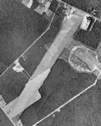
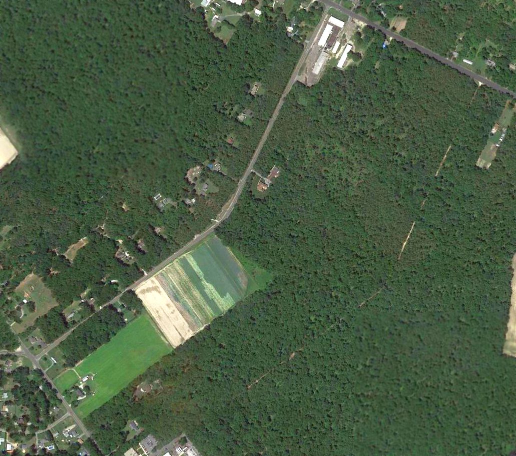
As seen in the 1995 USGS aerial photo, the majority of the property of the former Marlton-Medford Airport had been covered by houses,
with a small open portion remaining in the center of the site.
There does not appear to be any remaining trace of the former airport, though.
The site of Marlton-Medford Airport is located south of the intersection of Evesboro Medford Road & Green Brook Drive.
____________________________________________________
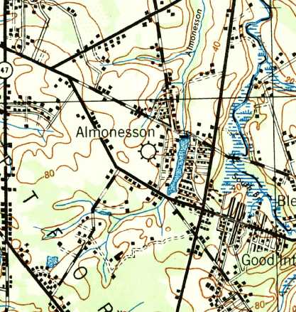
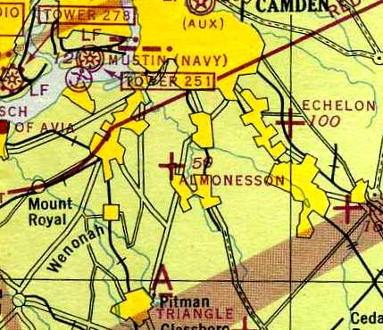
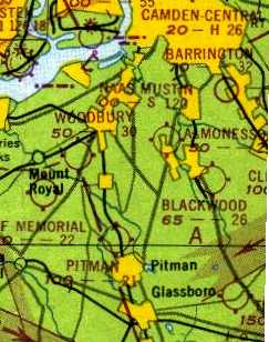
Almonesson Airport, Blackwood, NJ
39.82 North / 75.09 West (South of Philadelphia, PA)
The 1943 USGS topo map had an airport symbol for Almonesson Airport,
but located incorrectly on the west side of Almonesson Lake, as opposed to the airport's true location north of the lake.
This little general aviation airport was evidently established at some point between 1940-43,
as it was not listed among active airfields in The Airport Directory Company's 1937 Airport Directory (courtesy of Bob Rambo).
A 1940 aerial photo did not depict any signs of an airport, just an open grass field.
Almonesson Airport was not yet depicted on the November 1941 Washington Sectional Chart (courtesy of Chris Kennedy).
Howard Davis recalled, “I'm from Almonesson & my dad once flew out of the airport before the war (WWII).
I remember driving down the road with my mom & dad & seeing a plane departing Almonesson Airport.”
The earliest depiction of Almonesson Airport which has been located was on the 1943 USGS topo map.
It depicted an airport symbol for Almonesson Airport, but located incorrectly on the west side of Almonesson Lake,
as opposed to the airport's true location north of the lake.
The 1945 AAF Airfield Directory (courtesy of Scott Murdock) described Almonesson Airport
as a 57 acre rectangular property having 4 sod runways, the longest being the 2,000' north/south strip.
The field was said to have 4 hangars (the largest being a 90' x 30' wood & metal structure),
and to be owned & operated by private interests.
The earliest aeronautical chart depiction which has been located of Almonesson Airport
was on the May 1944 Washington Sectional Chart.
It depicted Almonesson as an auxiliary airfield.
Walt Ellis recalled, “A neighbor showed me a photo of Almonesson Airport.
He had the photo because the house across the street is where he was born.
He said his uncle owned the ground & leased it to Ralph Jones.”
Kent Johnson recalled, “Almonesson Airport... It was active when I was a kid of 5 years.
I would say it was opened from post WWII.
I don't know if Johnny Bigham owned it or not but he ran his crop-dusting business from there.
Johnny was more the daredevil than my father & lived his life, apparently, just that way & died that way.
Johnny came down too close to high power lines & crashed while doing a crop-dusting job.”
The last depiction which has been located of Almonesson Airport was on the 1949 Washington Sectional Chart.
An undated (circa 1940s?) aerial view looking northeast showed Almonesson Airport as having a grass airfield with 3 small hangars along the east side.
Two single-engine aircraft were visible next to the hangars.
The last photo which has been located showing aircraft at Almonesson Airport was a 4/20/51 USGS aerial view,
which showed one single-engine aircraft next to the 3 hangars on the east side of the field.
A 4th hangar had evidently been added on the southwest side of the field, not seen in the earlier photo.
Almonesson Airport was evidently closed (for reasons unknown) at some point in 1951,
as it was no longer depicted on the 1951 Washington Sectional Chart (courtesy of Mike Keefe).
A 1956 aerial photo showed that 3 of the 4 hangars had been removed at some point between 1951-56,
but the airfield area remained clear.
Walt Ellis recalled, “I started flying at Echelon Airfield in 1958 so Almonesson had stopped operating by then.”
A 1963 aerial photo showed that the last hangar had been removed at some point between 1956-63,
but the airfield area remained clear.
A 1970 aerial photo showed that the airfield area remained largely intact.
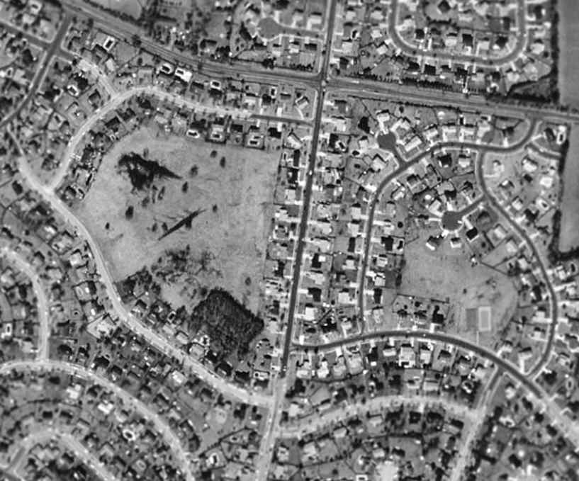
A 1995 aerial photo showed that several commercial buildings had been constructed over the airport property at some point between 1970-95.
A 10/8/11 aerial view shows no trace remaining of Almonesson Airport.
Kent Johnson reported in 2011, “The Home Depot & Country Buffet now sit on the original property & runway.”
The site of Almonesson Airport is located northwest of the intersection of Cooper Street & Route 41.
____________________________________________________
39.76 North / 75.14 West (South of Philadelphia, PA)
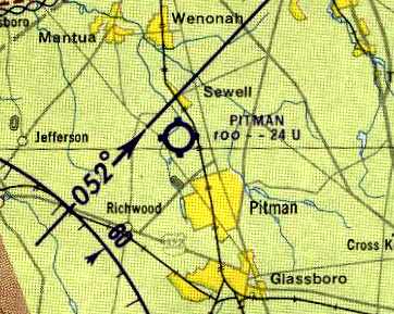
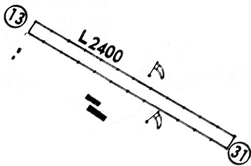
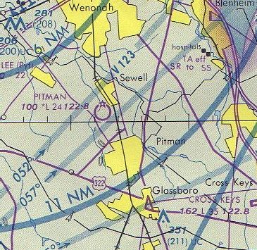
Pitman Airport, as depicted on the November 1945 Washington Sectional Chart (courtesy of John Voss).
This little general aviation airport was evidently established at some point in 1945,
as it was not yet depicted on the June 1945 Washington Sectional Chart (according to Chris Kennedy).
The earliest depiction of Pitman Airport which has been located
was on the November 1945 Washington Sectional Chart (courtesy of John Voss).
It depicted Pitman as a commercial/municipal airport.
Joe Rattigan recalled, “My grandfather was Ralph Jones,who ran Pitman Airport.
I believe he leased the property.
He taught people to fly. His business was Jones Flying Service.”
Brian Lott recalled, “My Dad knew Ralph Jones from back in the 1940s.
My Dad also worked as a Flight Instructor for Ralph Jones.
Charles Klineberg (spelling?) was the A & P at the time.
Ralph Jones (called Jonesy, by the guys who flew there)
moved the corrugated hangars from Almonesson to his next airport at Blackwood & then finally moved them to Pitman.”
Brian continued, “My Dad's memories of flying at Jonesy's airports are fond ones.
He said that Jonesy had a great personality & was someone that everyone liked.
Dad liked flying there because Jonesy would always buy & sell airplanes.
Dad got to try the different airplanes that came along.
Brand new Luscombes & Cub Cruisers were airplanes that he mentioned from time to time.
They used to put on mini airshows on the weekends to stimulate interest & sell airplane rides.
Jonesy even had pet monkeys which would perform parachute jumps.”
Ernest Geisert recalled, “Pitman Airport... Michael Di Ciurcio was the operator in the late 1940s & early 1950s.
In 1950 I was going to buy a Taylorcraft & Mike checked me out in one.
He may have been the one who started the airport. He was there until around the time Jonesy took over.”
The 1951 USGS topo map (courtesy of Harry Silvers)
depicted Pitman Airport as having a single unpaved east/west runway,
with 2 buildings along the south side of the field.
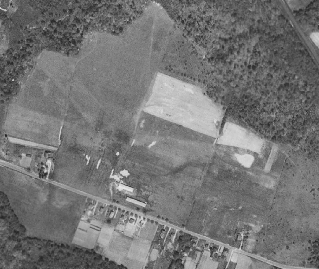
The earliest photo which has been located of Pitman Airport was a 5/2/51 USGS aerial view.
It depicted Pitman as having 2 grass runways, with 2 hangars on the south side.
The 1955 NJ Airport Directory (courtesy of Harry Silvers)
depicted Pitman Airport as having a single unpaved 2,400' west-northwest/east-northeast runway,
with 2 buildings along the south side of the field.
The operator was listed as Jones Flying Service,
and the manager was listed as Ralph Jones.
A 1956 aerial photo depicted Pitman as having a single northwest/southeast unpaved runway,
with 7 light aircraft visible parked on the south side of the field.
A 1957 aerial photo depicted a dozen light aircraft parked at Pitman.
The 1961 Philadelphia Local Aeronautical Chart (courtesy of Mike Keefe)
depicted Pitman as having a 2,400' unpaved runway.
Barbara Jones recalled, “My mother grew up at Pitman Airport; her father was Ralph Jones [Pitman Airport operator].”
A 1963 aerial photo depicted a dozen light aircraft parked at Pitman.
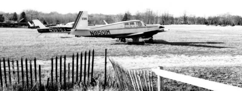
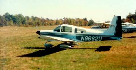
A June 1966 photo of a Mooney 20F at Pitman Airport.
Chuck Nash recalled, “Pitman Airport... I knew Ralph Jones when I started flying out of there at age 16 in 1966.
I started in a Piper 140, then Cessnas. I remember my flying roots at that old shack like it was yesterday. What a great start!!”
Joseph Rethemeyer recalled, “When I was 12-14 years old, I went to work for Pitman Airport.
This was owned, (not the land) but the airport by Ralph Jones.
He was the best friend I ever had, of course it was never mutual cause he was the hardest person to get along with I ever knew in my life,
but nonetheless I had, and have a great regard for the man.
He taught me the art of bad habit flying, doing a roll to Charlies house.”
President Lyndon Johnson met with Soviet Premier Aleksei Kosygin
from June 23-25, 1967 in Glassboro for a 3-day summit conference.
They met at Glassboro State College, later renamed Rowan University.
According to Barbara Jones, the summit attendees “used Pitman as a base.”
The 1968 Flight Guide (courtesy of Robert Levittan) depicted Pitman as having a 2,400' unpaved Runway 13/31,
and 4 small buildings on the southwest side.
Bob Kobrin recalled, “I took my early flying lessons to 1st Solo at Pitman in 1968, from Jones Flying Service.
They flew Cessna 150 trainers.
'Jones' (Ralph) was a perfect Hollywood image of a 1930s barnstormer pilot 30 years later.
Skinny, grizzled, and scraggly - and a GREAT pilot. I only flew with him once.
My instructor was Harry Williams, who idolized Jones and, regrettably, tried to emulate him.”
Bob continued, “The field was an 1,800' grass strip, though 300' of one end was not used - unless you were taking off from that end.
That was because the opposite end of the strip had the TALLEST stand of trees in the WORLD beyond it,
and as a heavy fellow in a Cessna 152, I had to use the 300' overrun to help get over them.
Perhaps they were not the VERY tallest trees, but flying toward them, they sure looked it!”
Bob continued, “Sorry to say this, but alcohol was a problem at the airport.
I had been taking lessons from Harry Williams, but one day he called in sick.
Jones took me up. He reeked of alcohol, and was slightly wobbly.
I have to this day no idea why I got into the plane with this guy, but I did.
When he demonstrated maneuvers, his flying was the smoothest anyone could possibly make in a 150!
That's why I think of him as a great pilot. Better than I'll ever be even when he was stoned.
Somehow that skill kept him alive all those years.
Unfortunately, Harry Williams was emulating his hero in the bottle as well as the sky, but he was not quite good enough.
On July 4, 1969 my girlfriend & I stopped by the airport (by car)
to reschedule her birthday present first flying lesson (with Harry) planned for the next day.
We were told that just a few hours earlier, Harry & a student had taken a Cub for a joyride.
Harry made 3 consecutive loops, the last of which hit the ground.
Too much celebrating the 4th, too much trying to be like Jones.
He left a young wife & a new baby, and somehow my girlfriend never did take that lesson.”
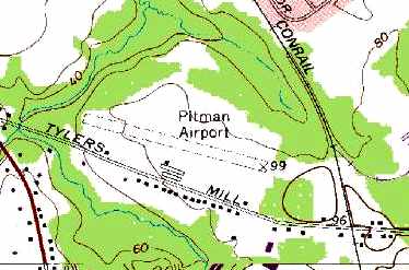
Mike Gentile recalled, “The old Airport was located on Tyler's Mill Road in Mantua Township.
It was owned by the Prickett family of Sewell N.J.
They used the surrounding area for their nursery business.
It was also the base of operations for a local crop duster in the 1960s & 1970s (Duffy's Flying Service I believe).”
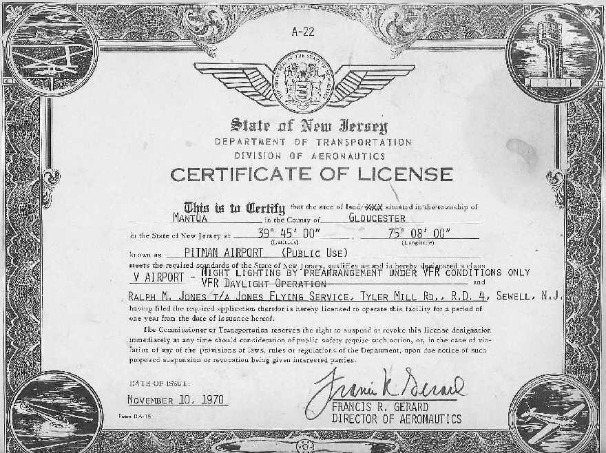
The 1970 NJ Division of Aeronautics Certificate of License for Pitman Airport (courtesy of Joe Rattigan).
A 1970 aerial photo depicted Pitman Airport as having a single unpaved east/west runway,
and over 20 light aircraft parked on the south side of the field.
Joe O'Mara recalled, “I first became familiar with Pitman Airport because as a high school freshman we had a flying club that was mentored by a teacher named Dick Schiavo.
Although it was called a flying club nobody actually flew...we just learned about basic aviation stuff
and Mr. Schiavo taught us things that would be useful to eventually pass the private pilot written exam.
On weekends in the summer Mr.Schiavo flew specially equipped banner towing Cubs out of Pitman to drag signs up & down the Jersey shore.
On Fall weekends he would hit all the high school football games & Veteran's stadium.
I was hired to assemble the signs & carefully lay them out with a long lead rope carefully placed between 2 poles
which Dick would fly between just high enough to capture the rope with a hook & beautifully wist the sign off the ground.
Then all 110 horsepower of the modified Cub's engine was required to get it to adequate altitude before the sign was able to get caught in the tree's at the end of the runway.
If anyone remembers 'Eat Habbersett's Sausage' signs fly by at a local football game... well that was probably me that put those words together.”
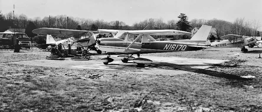
Joe continued, “According to my logbook on 5/23/70 I ferried Cub N71095 [pictured] from Cross Keys toPitman.
That would have been the day that Ed Black officially took over theFixed Base Operation from Ralph Jones who was retiring from instructing.
I'm not sure who piloted the other Cub over but we arrived together.
I remember turning short final behind the other Cub & with the imagination of a 16 year old I pictured 2 Spitfires landing after a successful sortie.
The runway grass was thin at that time & there were some exposed dirt patches which I tried hard to miss.
The runway was not even close to flat &there was a pronounced drop in grade from east to west.
Overall, the facility seemed a lot more rough around the edges to me than Cross Keys Airport
which led me to feel that maybe we had stepped down a notch as compared to the relatively luxurious amenities of Cross Keys.
It took a while butPitman Airport eventually grew on me. I remember the bike ride to Pitman took a lot longer than the bike ride to Cross Keys.
In those days our parents didn't chauffeur us around like today so I usually made that triponce or twice a week.”
Joe continued, “When I popped out of the Cub at our new home there was somewhat of a welcoming committee
of the old & the new tenants & a happy mixture of aircraft owners & pilots.
I was introduced to Ralph Jones by Ed Black for the first time.
He was one of those bigger than life kind of guys who you just knew could walk his talk.
It was also quite obvious that he had been 'celebrating' his imminent retirement for quite sometime & as I recall this was still before lunch time.
He pulled himself into the Cub with the speed & surety that you would expect from Santa mounting his sleigh.
He said 'give me a prop son'. I looked alarmingly at Mr. Black & he gave me an assuring nod.
I pulled it through once & he yelled 'contact' & the mighty 75 horse motor coughed to life
(the other Cub N7497H had a 65 hp engine but interestingly was faster & climbed better).”
Joe continued, “I was expecting the worse but what I saw was simply amazing.
He took off directly from the tie down area & had the airplane in the air in what looked like 200 feet.
He flew around the airport at no more than 300 feet altitude & never left the boundary of the airport but did some amazing things I did not know the Cub was capable of doing.
He then landed & finished his rollout right at the tiedown spot.
He popped back out of the plane & said 'That's a pretty damn good Cub.'
I remember thinking... 'What? No it's a great Cub....You got a better one?', but I said nothing.
Joe continued, “The rest of the day was spent listening to hanger flying resplendent with tall stories in the tiny airport office.
One story I remember in particular was when Ralph recalled winning abet by landing his airplane & taking back off again
between the goal posts of the old Kennedy Stadium that used to be on Broad Street in Philly.
The stadium was closed so it was not witnessed by anyone except the observers in another airplane.
All the more amazing when you consider it's on the final approach for Philadelphia International Airport.”
Joe continued, “One of the other things that sticks with me was the vehicles Mr Black inherited with the airport lease.
Once a week we had to gather all the 55 gallon steel trash cans & take them to the 'dump' which was a large hole back in the woods on the other side of the runway.
We had a 1948 Willey's Jeep truck which was absolutely indestructible. Trust me, 16 years old boys can destroy about anything.
To cut the grass we had a 1922 Case tractor that had been 'updated' with rubber tires, electric starter& abrush-hogmower.
The interesting part of this machine was that it did not have a radiator cap so the water would boil off while you were mowing.
The runway was about 2,500' including overruns on both ends.
Thebrush-hogwas5 feet wide so it took about 25 passes back & forth to cut the runway & taxiway which is roughly 12 miles of mowing.
Every 4th pass I needed to stop & fill the radiator If I forgot to stop or lost count the old Case would just overheat & shut down.
There was no permanent damage but then I would need to walk back & bring a large bucket of water back on a cart.
After about 20 minutes the tractor would restart. About every 10th pass I needed to stop & top off the oil & I usually topped off the gas at the same time.
At that time we didn't have an auto gas pump so it ran of 110avgas. I believe if that machine is still out there somewhere it will still start & run forever.”
Joe continued, “I give special mention to Mr. Ed Black who we kids used to refer to as 'the General'.
He was one heck of an aviator, instructor,and human being.
He treated all the kids who came around the airport sternly but with respect & he was very generous with his time, money & airplanes.
He was a man of great character & he always tried to do the right thing.”
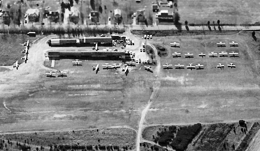
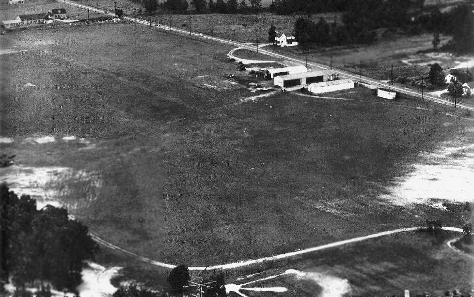
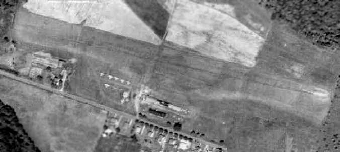
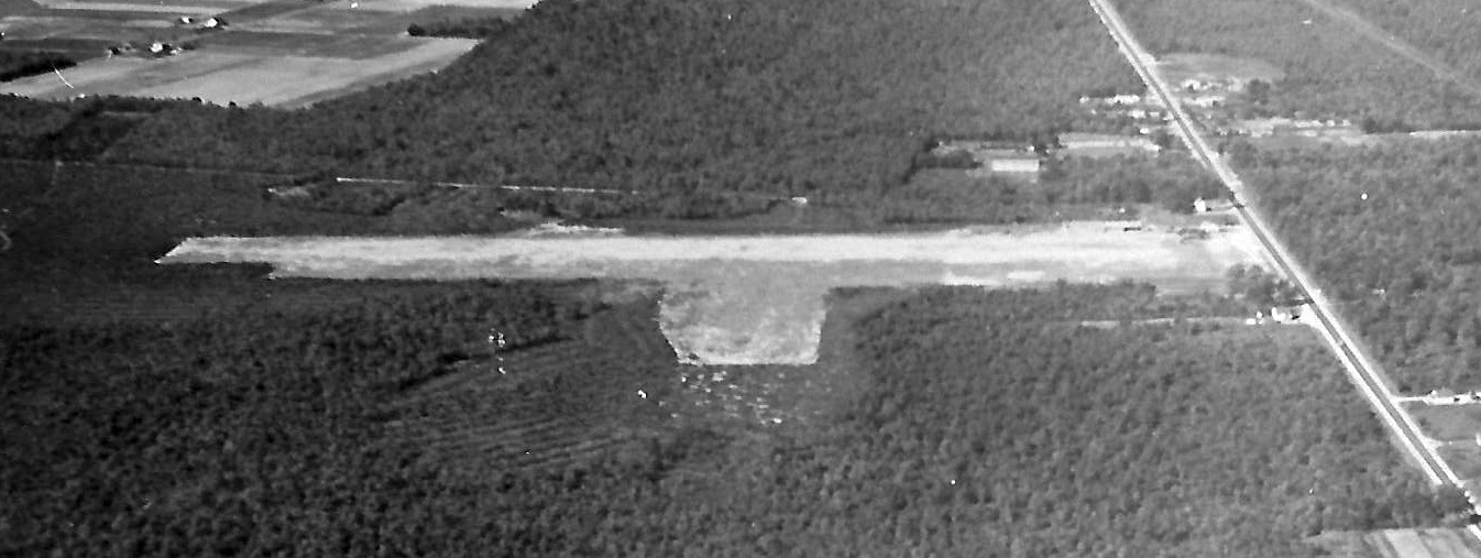
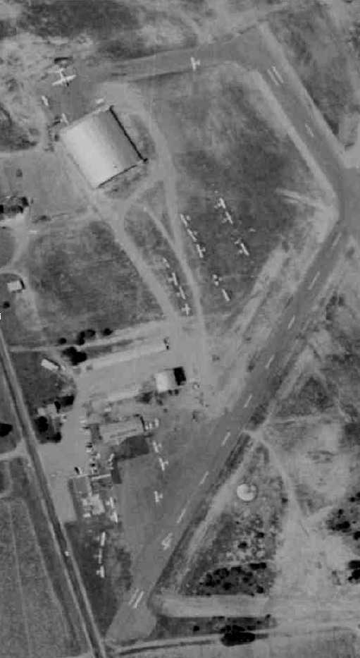
A 12/3/72 aerial view by Charles Findeisen (courtesy of Harry Silvers) looking south at Pitman Airport perhaps at its zenith of popularity,
with over 30 light aircraft visible parked on the south side of the field.
The 1975 Washington Sectional Chart (courtesy of Ed Drury) depicted Pitman as having a 2,400' unpaved runway.
A 2/10/75 photo by Charles Findeisen (courtesy of Harry Silvers) of Pitman Airport.
Harry observed the pictures “shows rental aircraft C-150 N1617Q, J-3 N71095, and J-3 N7497H.
Look how muddy the field was. When it was muddy you did your run-up at the tie down then taxi & take off without stopping.
When you land to the west you were instructed to over fly the 1st half of the runway & land on the 2nd half.”
Two 1978 photos by Stan Sikorski of Duffy's Flying Service's AgWagon & 450hp modified Stearman,
parked at the east end of Pitman Airport's hanger line.
Stan Sikorski recalled, “I was a kid of 14 when I met some agricultural pilots that were using a small farm strip in Indian Mills, NJ.
As I got to know them, I found that they were all working for an outfit called 'D's Flying Service' based at the Pitman Airport.
They had a modified 450 horsepower Pratt & Whitney powered Stearman,
a Cessna Ag Truck, a Cessna Ag Wagon, & a Piper J-3 Super Cub.
My 1st visit to Pitman blew me away.
It was a single grass strip, grass parking area, a concrete patch for fueling pumps, and 2 rows of corrugated metal hangars.
The place smelled like oil & history.
I spent many days there working for rides, enjoying the personalities
and learning many things about flying & life in general from them, and even took flying lessons.”
Stan continued, “The place was amazing. Everything a local nostalgic airport should be.
Stozny would pull in to fly off in his Volksplane, coffee chats around the hangars,
afternoon aerobatics from some just because they could.
A pilots' lounge was built for the evenings where everyone could unwind with a beer & darts after a long day.”
Stan continued, “One of the customers that D's serviced was the Hammonton Blueberry farm (Clements).
They used to use that strip [Crescent Airfield].
I got to take a flight in the J-3 & shadow their head pilot, Harvey Surran, as he sprayed the field.”
A 1978 photo by Stan Sikorski of looking west at Duffy's Flying Service's Cessna AgTruck at the east end of Pitman Airport's hangar line.
The 1981 Philadelphia Terminal Aeronautical Chart (courtesy of Jay Cooke)
depicted Pitman as having a 2,400' unpaved runway.
Several circa 1982-84 photos by Eric Muse of a Cessna 172, Cessna AgTruck, and Lake Buccaneer at Pitman Airport.
Eric recalled, “I worked there part time from 1980-84 while I was in High school.
I took lessons there & soloed in the early 1980s.
The school at that time was Blacks Flying Service which worked under Ralph Jones.
The owner/instructor/mechanic/manager was a guy named Dick Fekete.
He also ran an aerial photo business as well.”
Mike Gentile recalled, “I have flown out of this airport a few times about 20 years ago [1985].
It was a fairly smooth turf runway about 1,500' long with a few metal hangars.”
An October 1986 photo by Brian Lott of Pitman Airport's office building.
Brian Lott recalled of the corrugated hangars at Pitman, “They were still standing there in October 1986
when my Dad & I flew into Pitman in the Grumman Cheetah which we owned at the time.
The field was very rough & the takeoff was quite an adventure but we got out of there OK.
We were there on a Monday & the place was deserted.
It was in pretty dilapidated shape at the time.”
An October 1986 photo by Brian Lott of his Grumman Cheetah at Pitman Airport.
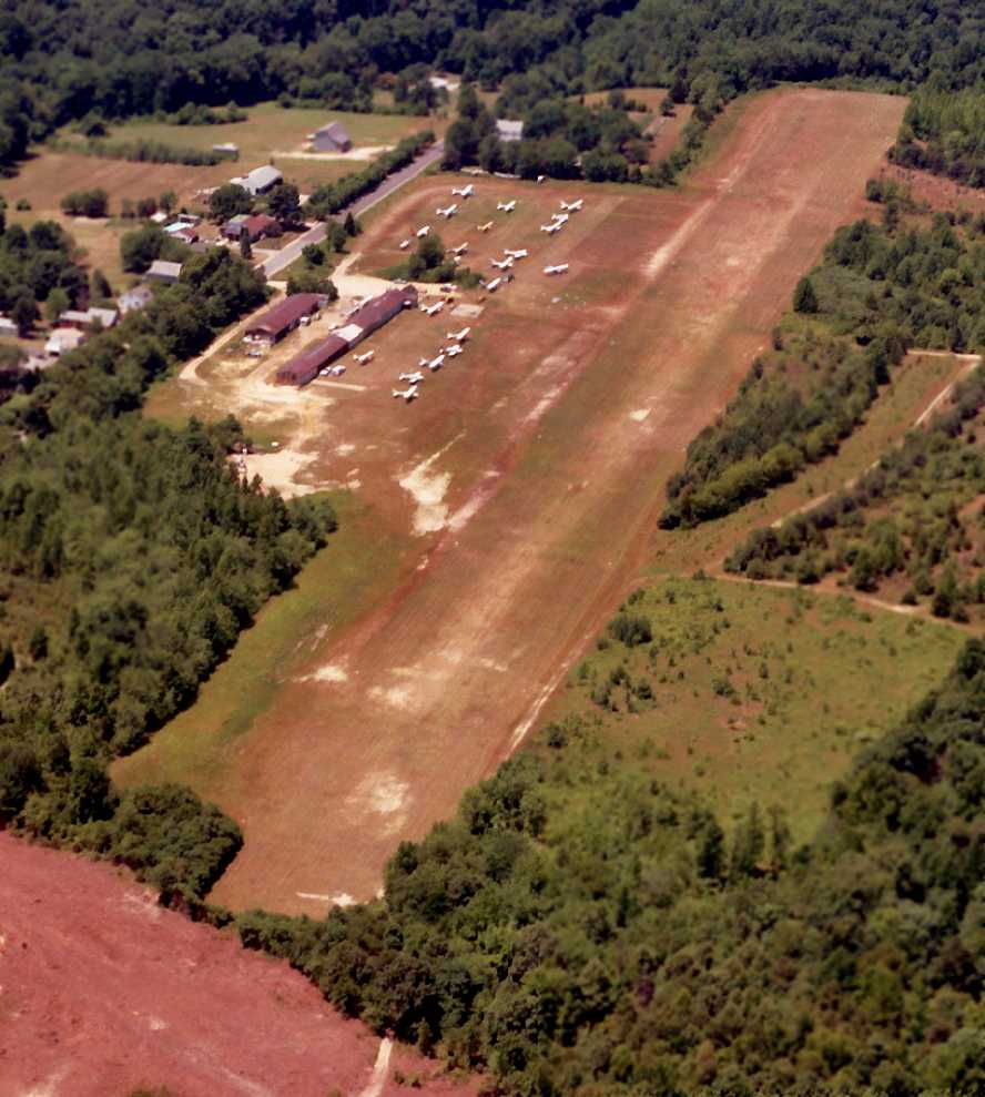
The last photo which has been located of Pitman Airport was a 7/4/86 aerial view by Charles Findeisen (courtesy of Harry Silvers) looking southwest,
showing 20 light aircraft parked on the south side of the field.
Harry observed, “Notice the new Route 55 just starting clearing off the end of the runway.”
The last chart depiction which has been located of Pitman Airport as an active airfield
was on the March 1987 Philadelphia Terminal Aeronautical Chart (courtesy of Kevin O'Reilly).
It depicted Pitman as having a 2,400' unpaved runway.
Ernest Geisert recalled, “When Mr. Di Ciurcio left Pitman some of the hangars were moved to Vineland Downtown Airport.”
Mike Gentile recalled, “It closed in the 1980s after a devastating fire.
They sold the property in the mid 1980s to a developer
which I believe began construction in the spring of 1988.”
By the time of the 1991 Washington Sectional Chart (courtesy of Mike Keefe),
Pitman Airport was no longer depicted at all.
7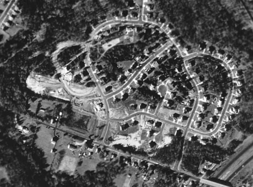
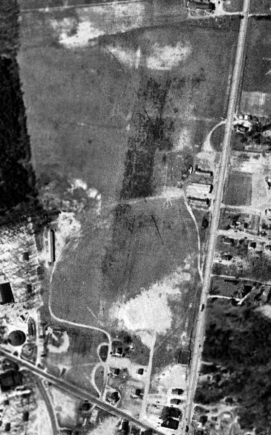
The 1995 USGS aerial photo showed that the site of Pitman Airport had been covered with a new residential development.
However, the clearing of the northwest end of the former runway was still recognizable.
It does not appear as if any of the former airport buildings remained.
Strangely, Pitman Airport was still depicted on the 1998 USGS topo map,
even though the 1995 aerial photo showed that it had ceased to exist at least 3 years before.
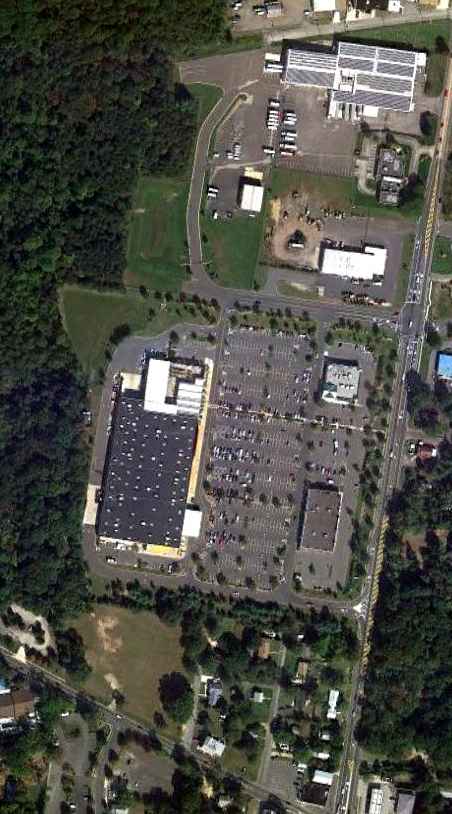
The site of Pitman Airport is located northwest of the intersection of Tyler's Mill Road & Route 55.
____________________________________________________
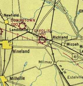
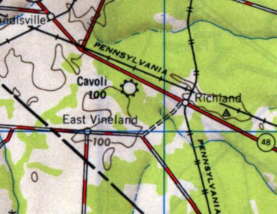
39.5, -74.9 (South of Philadelphia, PA)
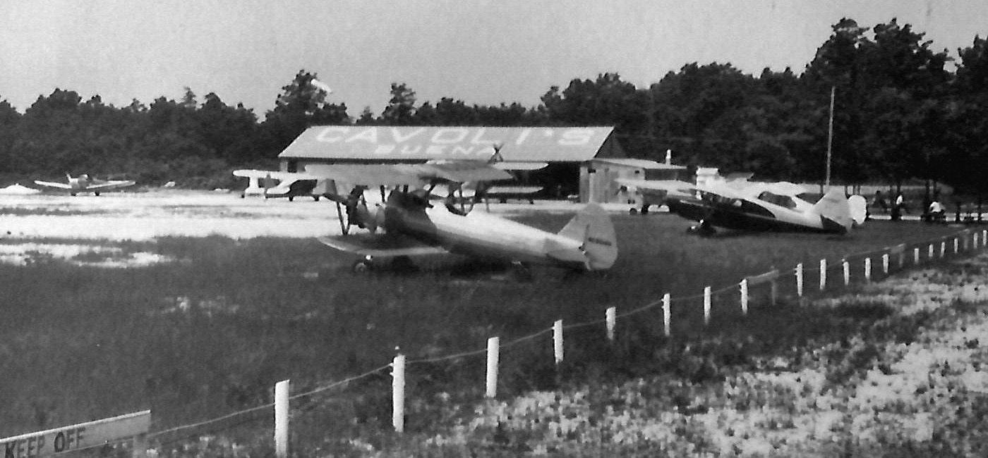
"Cavolis" Airport, as depicted on the 1946 Washington Sectional Chart (courtesy of Mike Keefe).
Cavoli's Airport was located "on the Harding Highway in Buena", according to Wallace Murray.
"The airport was run by Joseph Cavoli & his son Gene.
The Cavolis had literally hacked this airport out of the woods.
It was started in 1944 & went into operation in early 1946.
It had a 4,250' grass strip (generally north/south) & was very smooth.
Their business was WW2 GI-bill flight school & charter."
Randy Cavoli reported, “I am the grandson of Joe Cavoli, who along with his sons, including my father, built their airfield.
His sons were my father Robert, my uncle Fred & my uncle Gene who was the oldest & most involved with the airport.
They did hack that airport out of the woods right off Route 40 in Buena, beween Route 40 & Tuckahoe Road.
I have some vague recollections of being there when I was about 4 or 5.
I don’t remember any airplanes, but remember an engine & some propellers & other parts laying in the hangar.
The earliest aeronautical chart depiction of Cavoli's Airport which has been located
was on the 1946 Washington Sectional Chart (courtesy of Mike Keefe).
It depicted "Cavolis" as a commercial airport.
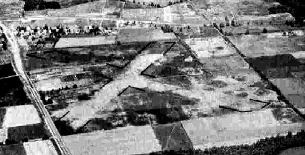
Cavoli Airport, as depicted on the 1946 USGS topo map.
A circa 1940s-50s aerial view looking northwest at Cavoli's Airport (courtesy of Randy Cavoli).
Randy observed, “The picture shows the airport & a cross runway that my father says they started but never finished.”
A circa 1940s-50s photo of several planes parked at Cavoli's Airport (courtesy of Randy Cavoli), showing the hangar marked “Cavoli's Buena”.
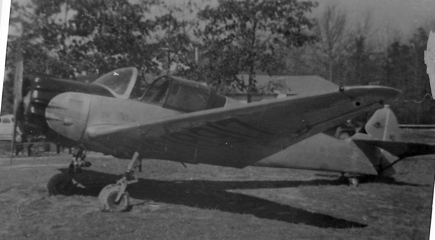
A circa 1940s-50s photo of a Ryan SC-W at Cavoli's Airport (courtesy of Randy Cavoli).
Randy Cavoli reported, it was “a very rare Ryan SC-W that they owned for a while.
I believe there was only 14 of these built & sadly my Uncle Gene told me someone ran it out of gas & crashed it somewhere in Virginia.”
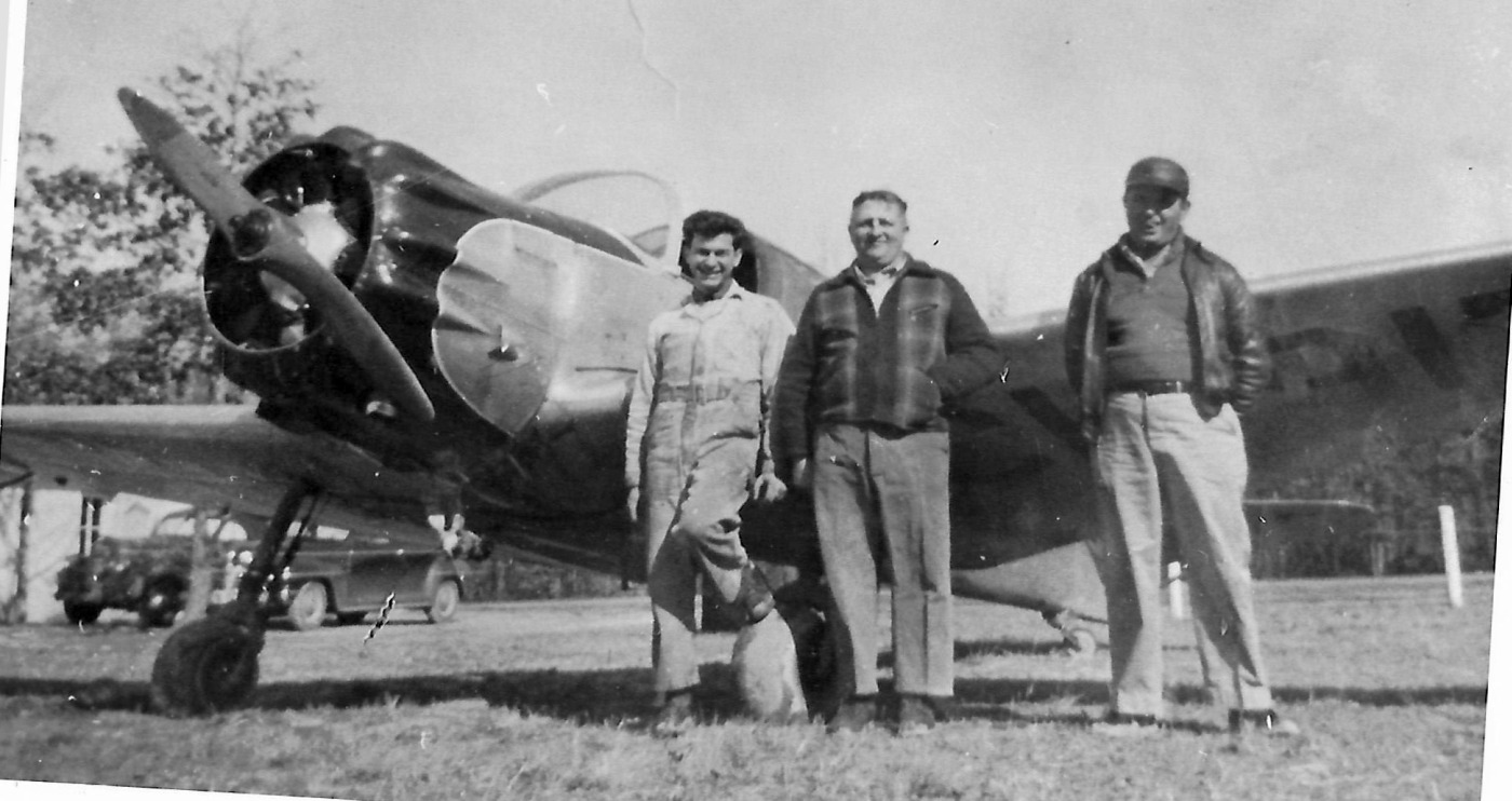
A circa 1940s-50s photo of a group in front of a Ryan SC-W at Cavoli's Airport (courtesy of Randy Cavoli).
Randy Cavoli reported, the people pictured are “my Uncle Gene, My Grandfather, Joe Cavoli, and a man I don’t know & neither did my dad. Possibly an instructor?”
Wallace Murray recalled, "In 1949 I was hired at Cavoli's Airport.
By the time I got there in 1949 the GI-bill program was winding down
but they were still busy & needed someone to take care of their fleet of airplanes.
While at the airport Gene helped me receive my Private & Commercial pilot's licenses at a very reduced rate.
By mid-1950 things were really slowing down in flight training & the Cavolis offered me the shop to take over on my own
which I did until 1951 when I was drafted into the Korean conflict."
A 1951 aerial view depicted Cavoli's Airport as having a single northeast/southwest grass runway, with a single hangar at the northern end.
One single-engine aircraft was visible having just landed or taken off from the field.
"Cavoli" Airport was depicted on the 1955 Washington Sectional Chart (courtesy of Mike Keefe)
as having a 2,600' unpaved runway.
According to Wallace Murray, "It may have been that after this time [1955]
Joe Cavoli began selling off property a small parcel at a time
and accounted for the strip showing up at 2,600'."
Cavoli Airport was depicted on the 1956 USGS topo map as a single unpaved northeast/southwest runway,
labeled simply as “Airstrip”, with a few small buildings on the northeast end.
The earliest dated aerial photo which is available of Cavoli Airport was a 1956 aerial view.
It depicted the field as having a single northeast/southwest grass runway, with a single hangar at the northern end.
No aircraft were visible on the field.
A 1957 aerial view showed the airport in an unchanged manner.
Randy Cavoli reported, “My Grandparents moved to Florida in 1959 & the property was sold sometime after.”
Wallace Murray recalled, "The airport was permanently closed in 1959, according to Gene Cavoli."
By the time of the 1960 Washington Sectional Chart (courtesy of Mike Keefe),
Cavoli's Airport was no longer depicted at all.
Randy Cavoli reported, “I remember a big snowstorm sometime in the early 1960s collapsed part of the roof of the hangar.”
A 1963 aerial photo showed that Oak Road had been built right down the center of the former runway alignment.
Cavoli's Airport was also no longer depicted on the 1972 USGS topo map.
According to Wallace Murray, "There were large industrial buildings put on the runway at the north end."
The 1991 USGS aerial photo showed that Oak Road had been built right along the alignment of the former runway.
Wallace Murray reported in 2004, "I flew over the airport the last time about 3 years ago
and it was almost impossible to see where it used to be."
He also reported that the Cavoli home (across Oak Road from the airfield)
"was still standing & occupied 2 years ago."
A 2015 aerial view showed no trace remaining of Cavoli Airport.
Randy Cavoli reported in 2016, “Part of the hangar still exists as an antique shop or some sort of store.”
The site of Cavoli's Airport is located on the south corner of Harding Highway (Route 40) & Oak Road.
____________________________________________________
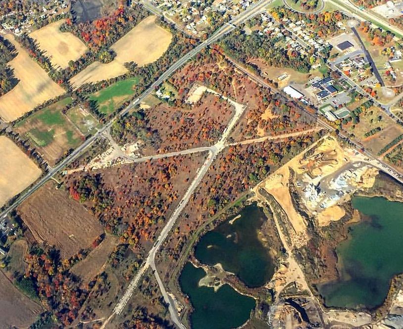
Aero-Haven Airport / Camden Burlington County Airport (16N), Berlin, NJ
39.82 North / 74.89 West (East of Philadelphia, PA)
The earliest beginnings of the Aero-Haven Airport were visible in a 1956 aerial photo,
when the field consisted of a single north/south clearing cut from the surrounding woods.
Aero-Haven Airport was evidently built at some point between 1940-56,
as a 1940 aerial view showed no sign of an airport – just woods.
The earliest depiction of Aero-Haven Airport were visible in a 1956 aerial photo,
which depicted a single north/south clearing cut from the surrounding woods.
No hangars or other improvements were visible.
A 1957 aerial view depicted the field in the same manner.
According to Wallace Murray, "I would say sometime in the 1950s
a Mr. Bill Kennedy & some associates built Aero Haven Airport."
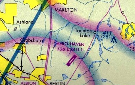
No airfield at this location was yet depicted on the 1961 Washington Sectional Chart (courtesy of Mike Keefe).
The earliest reference to the field which has been located was in the 1962 AOPA Airport Directory,
which described "Aero-Haven" airport as having a single 2,900' asphalt runway (4/22).
Wallace Murray recalled, "Soon after it was completed Mr. Kennedy had a falling out with his partners,
somehow he was able to keep them at bay for many years during which time he ran the airport very successfully."
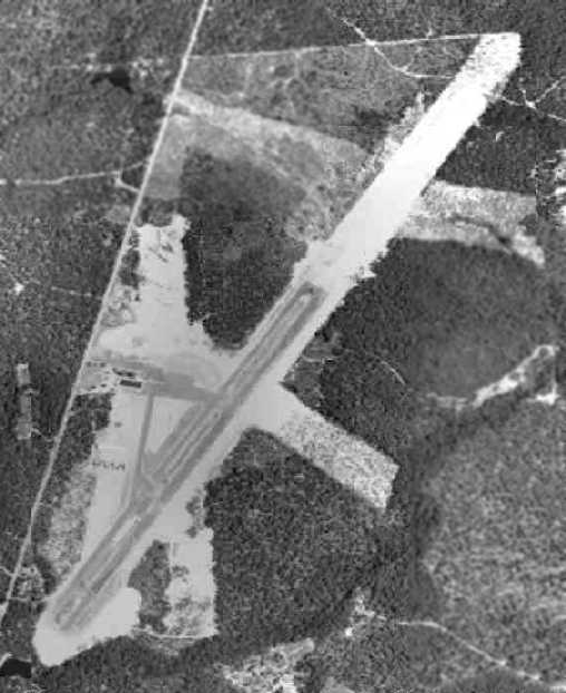
A 1963 aerial photo depicted the Aero-Haven Airport in a dramatically-expanded configuration, compared to the 1956 image.
The single north/south clearing had been replaced by a paved northeast/southwest runway,
and a paved taxiway & ramp, with hangars & a dozen aircraft parked on the west side of the field.
Note that the architects of the airport evidently had big plans, as the clearing for the new runway was roughly twice as long as the pavement,
and there were also 2 new clearings for what could have been intended to be crosswind runways.
None of this presumed future expansion was ever realized.
The earliest aeronautical chart depiction which has been located of Aero-Haven Airport
was on the 1964 Washington Sectional Chart (courtesy of John Voss).
It described Aero-Haven as having a single 2,780' bituminous runway.
The 1968 Flight Guide (courtesy of Robert Levittan) depicted Aero-Haven as having a 2,780' paved Runway 4/22,
and a parallel taxiway, ramp, and 3 buildings on the west side.
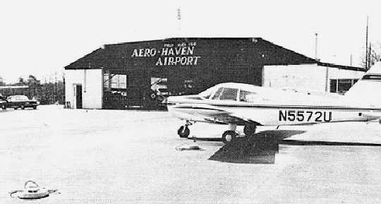
An undated photo of a Piper in front of a hangar at Aero-Haven.
Bob Kobrin recalled, “When I came back to NJ I was looking for an airport nearer to Cherry Hill.
So I started to use Aero-Haven, a paved strip & well-run a Piper FBO.
It was well-run & convenient, but by then my girlfriend had become my wife, and then became a mother, so I stopped flying in 1970.
You could buy a crib for the price of a 1-hour rental!”
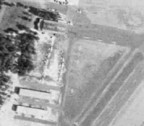
A closeup from a 1970 aerial photo depicted a dozen light aircraft parked at the Aero-Haven Airport.
The last aeronautical chart depiction which has been located of Aero-Haven Airport
was on the February 1975 Philadelphia Terminal Aeronautical Chart (courtesy of Mitchell Hymowitz).
It depicted Aero-Haven as having a 2,800' paved northeast/southwest runway.
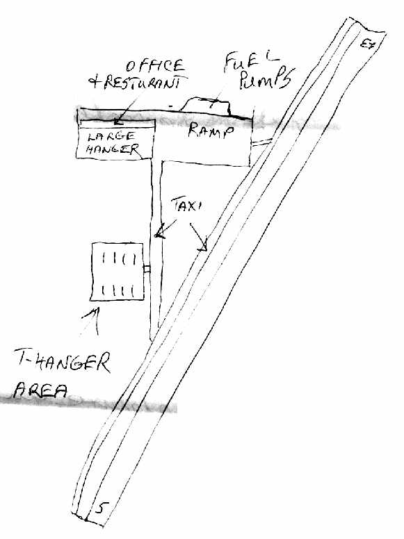
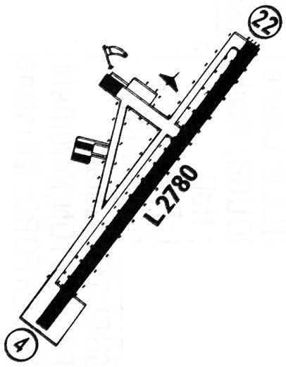
A diagram of the field layout of Aero Haven Airport, by Wallace Murray.
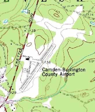
By the time of the 1981 USGS topo map,
the airport had apparently been renamed "Camden Burlington County Airport".
It was depicted as having single 2,900' asphalt runway, taxiways, a ramp, and at least one hangar.
Note that the topo map appeared to depict a clearing which was about twice as long as the paved runway,
and also 2 clearing for what could have been intended to be crosswind runways.
Wallace Murray recalled, "Finally the partners were able to oust him [airport founder Bill Kennedy]
and they took over the operation of the airport.
Apparently it was a disaster
and the airport never regained a successful stature & was finally closed."
Scott Roberts recalled, “The airport has been officially closed since the early 1980s,
and the locals had noticed late-night landings & take offs.
Investigation revealed drugs were being flown into the closed airport,
so the township started depositing piles of dirt on the runway.
Camden Burlington County Airport was no longer depicted at all on the 1991 Washington Sectional Chart (courtesy of Mike Keefe).
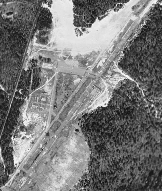
In the 1995 USGS aerial photo, the airfield was already closed, but still largely intact.
In a circa 2001 aerial photo, the paved ramp was still intact,
and closed runway yellow "X" markings were still visible along the northern half of the runway,
but a significant portion of the southern end of the runway had been removed,
with a circular road built over it.
A 1/18/01 BCT article (courtesy of Janek Kazimer) claimed that the Aero Haven Airport property was planned to be the location of a new recreation complex,
but apparently that never happened.
Scott Roberts reported in 2005, “The area has been developed around the airport,
however it is still sparse enough there it could reopen with little problem.
I wish someone would reopen it.”
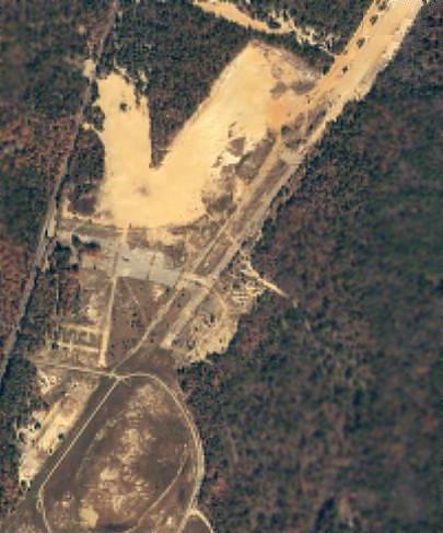
A circa 2006 aerial view looking north at the site of the Burlington County Airport,
showing the pavement from the ramp & runway.
Jay Reed reported in 2007, “Aero-Haven Airport was once a Superfund site for environmental cleanup.
The road at the airport's south is a waste water retention pond from the township sewage authority.”
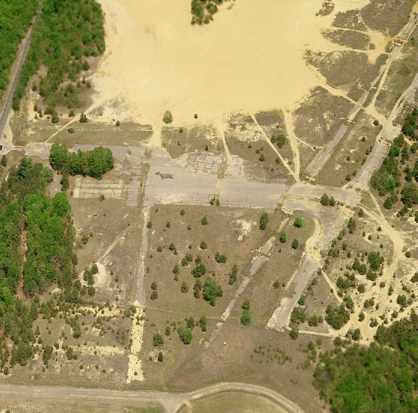
A 12/5/08 view looking north along the cracked runway pavement remains at the site of Aero Haven Airport.
A 12/5/08 photo of a hangar foundation at the site of Aero Haven Airport.
The site of Aero Haven Airport is located
northeast of the intersection of Kettle Run Road & Chestnut Avenue.
____________________________________________________
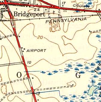
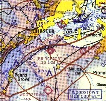
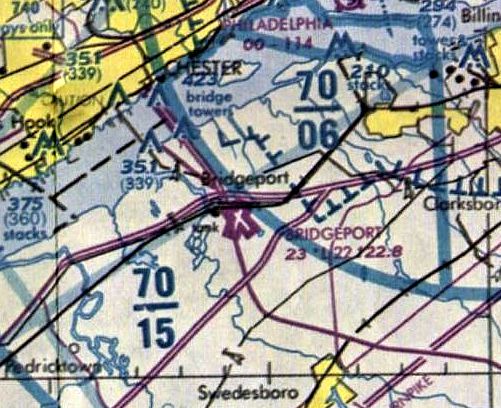
Bridgeport Airport (N83), Bridgeport, NJ
39.797, -75.343 (Southwest of Philadelphia International Airport, PA)
Bridgeport Airport, as depicted on the 1940 Washington Sectional Chart (courtesy of Mike Keefe).
The precise date of construction of Bridgeport Airport is not known,
but it was apparently built between 1935-40,
as it was not yet depicted on a circa early 1930s aerial photo,
and it was not depicted on the 1935 Washington Sectional Chart.
The earliest depiction of Bridgeport Airport which has been located
was on the 1940 Washington Sectional Chart (courtesy of Mike Keefe),
which depicted "Bridgeport" as an auxiliary airfield.
A wealth of memories about Bridgeport Airport were contributed by Charles Feldman:
"I know the airport existed before WW2.
It was just a sand strip (not grass).
It had a hump half way down it & the planes would get a launch off of it.
It wasn't very much but it worked.
The runway that goes right to the Route 322 was the only one."
Charles continued, "There where 3 hangars - the main had an office in it & had a concrete floor.
It was probably the first one built.
Behind it was 2 more garage type hangars; they where of the standard tee design & small.
The airplanes where all Piper J3s & Aeroncas. A Cessna was seldom seen.
No multi engine planes & few Taylorcrafts."
Charles continued, "When my family moved to Bridgeport I was 7 years old.
I spent lots of time at the airport.
I managed to get free rides by helping out with the work."
Charles continued, "The airport was in & out of the Cahill family for many years.
Gordon Cahill Sr. laughed that he owned the airport at least 6 times.
Every time he sold it he got it back for one reason or another."
According to John Goodale, “During WW2 my Mother-in-Law flew Civil Air Patrol out of the Bridgeport Airport
looking for German submarines in the Delaware River / Bay & in support of area air search & rescue.
Her husband stood by & watched her fly - always concerned.”
The earliest photo which has been located of Bridgeport Airport was a 5/10/43 aerial view looking north
from the 1945 AAF Airfield Directory (courtesy of Scott Murdock).
It depicted the field as having 2 unpaved runways.
The 1944 USGS topo map labeled the site simply as "Airport", but did not depict any runways.
The May 1944 Washington Sectional Chart (courtesy of Chris Kennedy)
continued to depict Bridgeport as an auxiliary airfield.
The 1945 AAF Airfield Directory (courtesy of Scott Murdock) described Bridgeport Airport
as a 73 acre rectangular property having 2 sand runways, measuring 2,750' northwest/southeast & 2,500' northeast/southwest.
The field was said to have 2 wood & metal hangars (the largest being 210' x 26'),
and to be owned & operated by private interests.
The 1945 Washington Sectional Chart (courtesy of John Voss),
depicted Bridgeport as a commercial airport.
Charles Feldman recalled, “The airport was used by pilots who wanted to get away from the city airports.
Lots of weekend flying was done here.
The Cahills taught many people to fly including myself.
After WW2 many ex GIs used the GI Bill to learn to fly.
I guess after that was over the business declined somewhat."
Charles continued, "The field was home to a crop dusting company.
I believe it operated under the name of Graham's Crop Dusting.
The operation was quite unique as the fields in South Jersey are small & have trees for hedgerows.
Therefore Stearman biplanes could not work the area.
So they used J3 Cubs with larger engines & dust hoppers in the back seat.
The J3s could work a very short or small field.
Graham 'Hammer' Denham was owner pilot & Tommy Brown was the other pilot.
Both Hammer & Gordon Cahill Senior were pilot instructors for the government in WWII.
They were excellent pilots."
The 1949 Washington Sectional Chart (courtesy of Mike Keefe)
described Bridgeport as having a 2,200' unpaved runway.
The Aerodromes table on the 1951 Washington Sectional Chart (courtesy of Mike Keefe)
described Bridgeport as having 2 runways, with the longest a mere 1,600' unpaved strip.
Walt Gouse reported that "I lived at the airport from 1951 to the early 1970s.
I used the pool, carried drinking water for the men building the large hangar in our back yard.
I spent a lot of time in the Cahill house, growing up with James & Karen.
Gordon Sr. & Jr. taught me to fly at the same time they were teaching Jimmie.
My Grandfather owned a portion of the airport land."
The runway at Bridgeport had been lengthened slightly by 1955,
as the 1955 Washington Sectional Chart (courtesy of Mike Keefe)
described the field as having 2 runways, with the longest being a 2,135' sand strip.
A 1956 aerial view depicted Bridgeport Airport as having 2 unpaved runways, with several hangars & 3 light aircraft on the west side of the field.
A 1958 aerial photo depicted the Bridgeport Airport in pretty much the same physical configuration,
but with 5 light aircraft visible on the field.
The 1959 Philadelphia Local Aeronautical Chart (according to Chris Kennedy)
described Bridgeport as having 2 runways, with the longest being a 2,135' sand strip.
At least one runway at Bridgeport was evidently paved within the next year,
as 1960 Washington Sectional Chart (courtesy of Mike Keefe)
described the field as having 2 runways, with the longest being a 2,100' blacktop strip.
Wallace Murray recalled, "I would say the late 1950s or early 1960s is about right for the purchase of Bridgeport Airport
by Doctor Eugene Spitz who at the age of 39 was already world-renowned as a brain surgeon.
He made all the improvements mentioned to the airport."
Wallace continued, "Soon after a very young man by the name of Clark Smith was working as a lineboy at the airport.
Somehow he caught the eye of Dr. Spitz
and they became very close, like father & son.
Dr. Spitz started bankrolling Clark's flight training
and soon he was the Doctor's personal pilot."
Wallace continued, "The Doctor kept buying planes & each time they were a higher performance airplane
that was always just ahead of Clark's experience & expertise level.
The Lodestar had no business in that airport
and when Clark came in to land they would stop traffic on Route 322 just in case he could not stop in time.
It was said he crossed the road more than once.
Clark became a very wealthy man in the employee of Dr. Spitz."
According to Charles Feldman, "The airport was paved on the main runway I would say in the early 1960s.
A Doctor Spitz from PA had purchased the airport & started to develop it.
They added the second runway after paving the first one & then the large hangar was erected (#4).
A new office building was built & a pool was there for the customers.
The Cahill homestead was now converted to a restaurant."
Charles continued, "Gordon Cahill Sr. was an employee of the new owners
and I took my first couple of flying lessons from him.
He asked me if I would take lessons from his son Gordon Jr. & I said yes.
So it was that I was the first student that young Gordon had & soloed.
This was in the summer of 1960."
A 1961 photo by Daniel Ceglia of a Piper Colt in which he took lessons from Gordon Cahill at Bridgeport.
"The photo is taken outside the office facing the end of Runway 4 & the road which is Route 322."
The 1962 AOPA Airport Directory described Bridgeport Airport as having 2 paved runways,
and listed the operator as Horizon Aero Service.
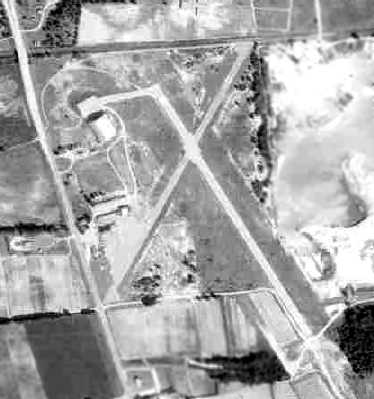
A 1963 aerial photo showed that Bridgeport's paved runway was in a slightly different orientation than its predecessor unpaved runway.
It also extended significantly further south.
It also showed the large hangar which had been built on the northwest corner of the property,
right over what had been the northwest end of the original runway.
The number of aircraft visible on the field had blossomed, to a total of 22.
The 1964 Washington Sectional Chart (courtesy of John Voss) described Bridgeport
as having 2 runways, with the primary runway being a 2,400' bituminous surface on a 3,500' turf strip.
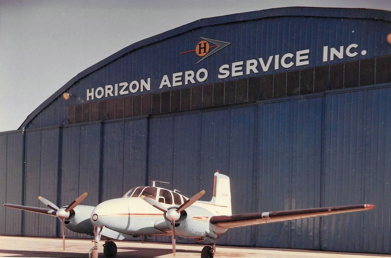
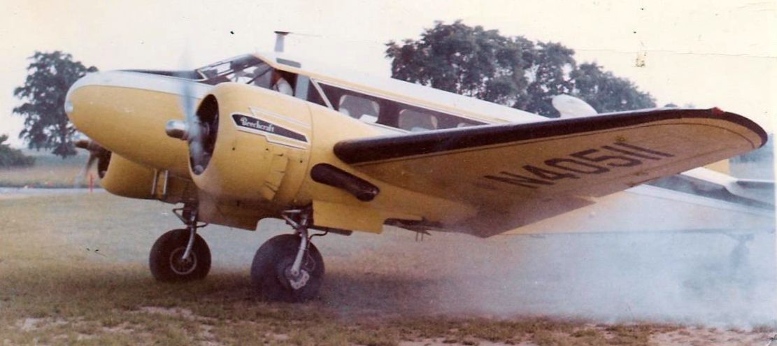
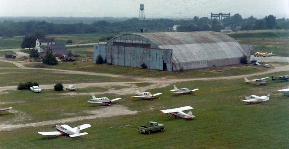
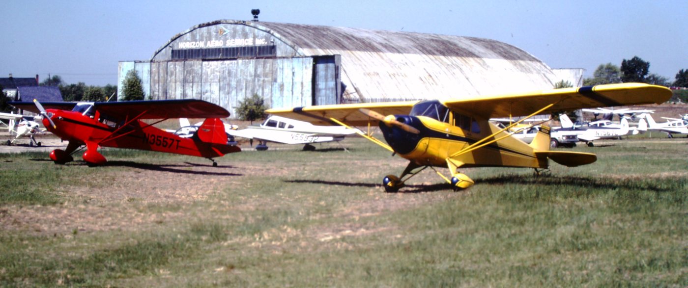
A 1960s photo by Al Osowski (courtesy of Eugene Smith) of a Beech Twin Bonanza in front of Bridgeport Airport's Horizon Aero Service hangar.
A 1960s photo by Al Osowski (courtesy of Eugene Smith) of a Beech 18 making a smoky engine start at Bridgeport Airport.
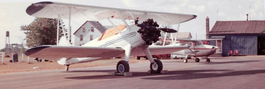
A 1960s photo by Al Osowski (courtesy of Eugene Smith) of a Stearman & Cessna 172 in front of several buildings at Bridgeport Airport.
Charles Feldman recalled, "During the Spitzs era many things happened.
Dr. Spitz needed a twin-engine airplane so one day a DC-3 came in to land.
It was an awesome sight.
No one thought that plane could make it in & out. But it did.
The doctor eventually bought a Lockheed Lodestar.
It flew out of the field on either runway but if a large truck was coming down Route 322 there could be trouble.
I can recall the wheels just clearing the car tops as it left the field."
Charles Feldman recalled, "The airport prospered for the next 5 years or so & then got into financially hard times.
It changed hands again. This was probably in 1967 or there about."
The 1968 Flight Guide (courtesy of Robert Levittan) depicted Bridgeport as having 2 paved 2,200 runways,
and 2 buildings on the west side.
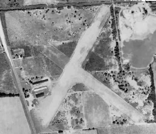
The last photo which has been located showing Bridgeport Airport while it was still operational was a 1970 aerial view.
It depicted the extension of the paved runway to the southeast, the new hangar on the northwest side,
and a total of 15 light aircraft on the west side of the field.
Brian Lott recalled, “Bridgeport... We visited there in the summer of 1970.
Richard 'Rip' Davis was the Fixed Base Operator at the time.
The highlight of the visit was a white J-3 that had been converted to a crop-duster
that we found sitting in one of the open hangars there.
It was N70728 which was the same NC70728 that my Dad had purchased brand new back in 1946
and he had based at Almonesson Airport.
There was a small cafe at Bridgeport & my Dad & I had lunch with Mr. Davis.
He talked about the bridge construction & how that would probably hurt the airport
and put the ferry service across the river out of business.
Shortly after returning to California from this trip we received a letter & a newspaper clipping.
The article was about an aircraft accident near Bridgeport.
Mr. Davis was killed when the Cherokee he was flying crashed into part of the bridge structure near the airport.
A sad memory indeed.”
A 1972-75 photo by Ken Morrison of Bridgeport Airport,
showing “the old Camden Central hangar which was relocated to Bridgeport after Camden closed.
I worked with an aircraft painter at Keystone Helicopter Corporation named Tom Larkin who had worked at Camden Central & was involved in moving the hangar to Bridgeport.
He painted the hanger the blue color seen in the photos.”
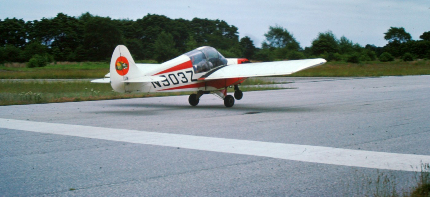
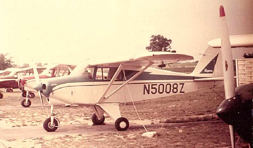
A mid-1970s photo by Ken Morrison of a Stits Flut-R-Bug on the Bridgeport Airport runway.
Ken recalled, “The Stits Flut-R-Bug (sometimes written Flutterbug) N903Z was built by Bill Thomas, a longtime Bridgeport pilot.
Bill built it as a single-place since he was a big guy. At the time of this photo, mid-1970s, it was owed by Earl Levers who converted it to 2-place.”
Ken Morrison recalled, “I based my Cub at Bridgeport from 1972-75 when I moved it to Shannon Airport in Downingtown PA.
Bridgeport was great place - I made a lot of friends there - it also had a small diner in an old farm house on the property.
There were no GA airports near our area in Delaware County PA.
We used to ride the Chester Ferry to the airport from Chester to Bridgeport until a bride was built over the river.”
A 1973-75 photo by Ken Morrison of Bridgeport Airport.
Ken observed, the picture showed “my red Taylorcraft F-19 & Bob Vance's Piper J-4A N26154.
Bob & Bill were brothers, from PA as I was. Bob & Bill & I were great friends.
Also seen is big hangar which was originally at the Camden [Central] Airport.”
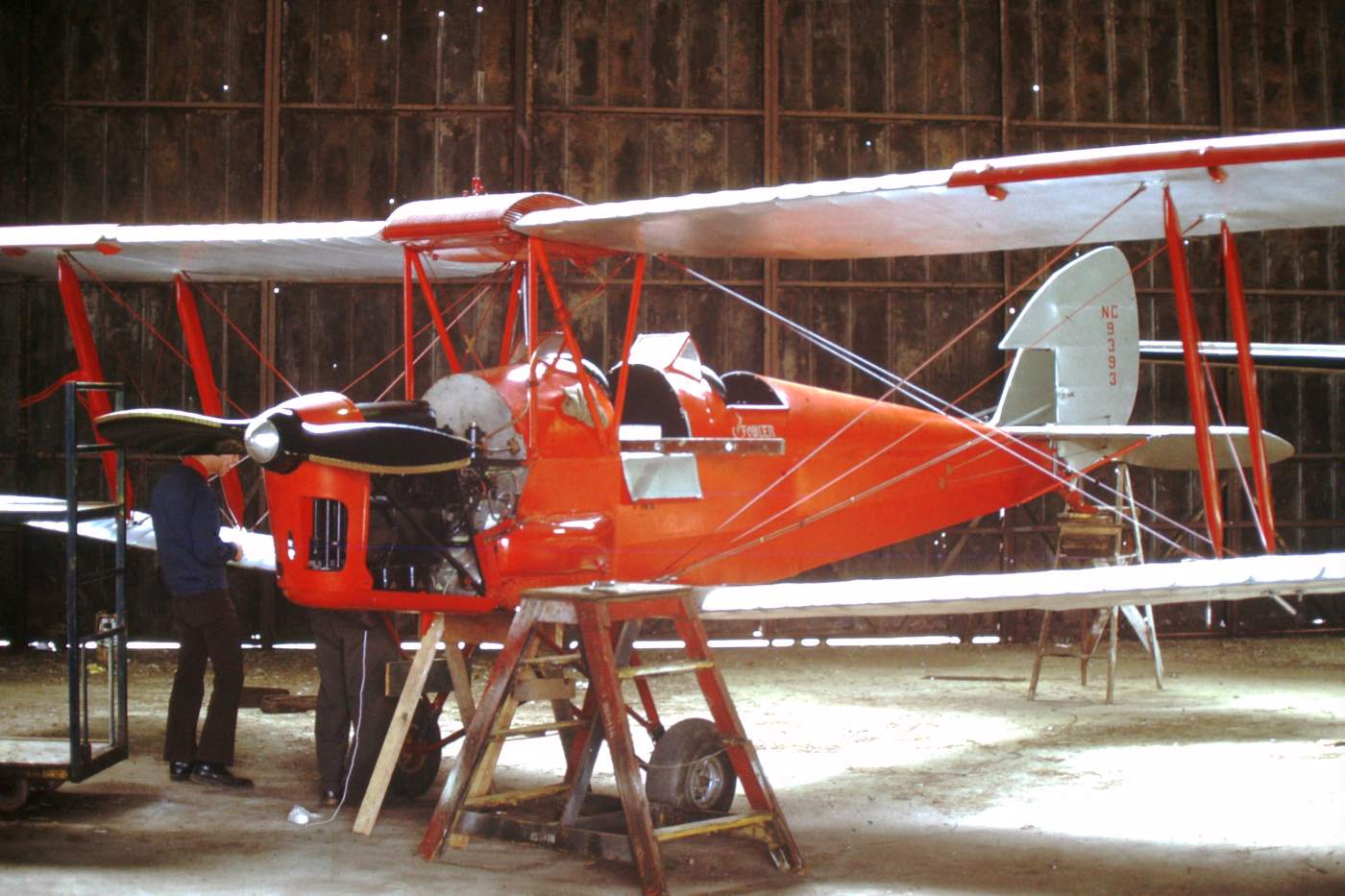
A 1972-75 photo by Ken Morrison “of the Tiger Moth, taken in the old Camden Central hangar which was relocated to Bridgeport after Camden NJ closed.
The airplane was owned by Crash Fowler. Bill Vance, a local pilot is seen on the left helping him rig the Tiger Moth. Crash is on the right.”
Jack Clowney recalled, “Bridgeport Airport.... I learned how to fly there in 1974, and Gordon Cahill Sr. was my instructor.
He was a fine pilot & just a great man. I remember Gordon Jr, flew for Eastern.
Our chief pilot was Trules Sembe, and Joe Musimecki was the Fixed Base Operator, and did crop dusting with Tommy Brown.
Learning how to fly there changed my life forever.
That airplane ride with Gordon Cahill changed my life forever.
I have flown all over the world in the last 30 years,but I still remember those wonderful folks & good times at Bridgeport,
and I think of this every time I fly out of PHL to come home, while climbing out of PHL on [Runway] 27 Left,
you look out & see the old airport, and think of days gone by.
A time when flying was a lot of fun.
And I ate many a hot dog & hamburger at the old restaurant there,
and drank a million cups of coffee, talking to old pilots, wonderful memories.”
The 1981 Philadelphia Terminal Aeronautical Chart (courtesy of Jay Cooke) depicted Bridgeport as having 2 paved runways.
A early 1980s photo by Eugene Smith of “The last working cropdusting shop at Bridgeport Airport: Aerial Applicators, the Piper Pawnee replaced the PA-18 Super Cub.”
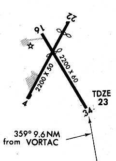
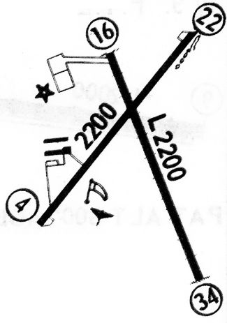
A 1986 Approach Plate (courtesy of John Clifford) for Bridgeport Airport's VOR Runway 34 approach.
The last aeronautical chart depiction which has been located of Bridgeport Airport
was on the March 1987 Washington Sectional Chart (courtesy of Kevin O'Reilly).
It depicted Bridgeport as having 2 paved runways, with the longest being 2,200'.
According to John Goodale, “In the late 1980s toward the end of its active life,
a major hangar fire gutted the large hangar.
It stood as a ghost, in gutted condition until eventually torn down for safety reasons.
Some planes burned.
I ate breakfast many times at the little airport café before it was closed. It was very small, close & cozy.
Toward the late 1980s at near the end of its life,
ultralight aircraft activities picked up & it became a local mecca for the area ultralight crowd for many miles around.”
According to the NJ Department of Transportation, Bridgeport Airport “officially closed on 12/15/88.
About 75 aircraft were based there, including many classic & tailwheel types.”
Charles Feldman recalled, "As the Philadelphia International Airport grew & the FAA Traffic rules changed
the little airport became a problem for the Control Zone of PHL.
So it was finally closed.”
According to New Garden Aviation, “Bridgeport Airport, lost to developmental pressures
that were derailed due to discovery of contamination from crop-dusting operations
causing Superfund designation which has prevented any use or reuse of the property.”
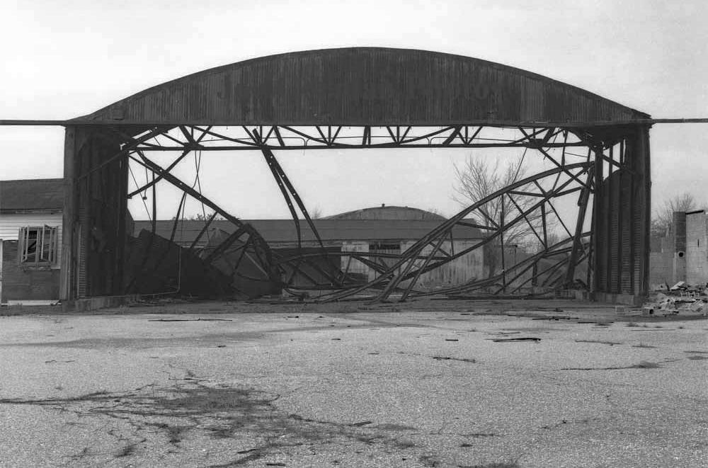
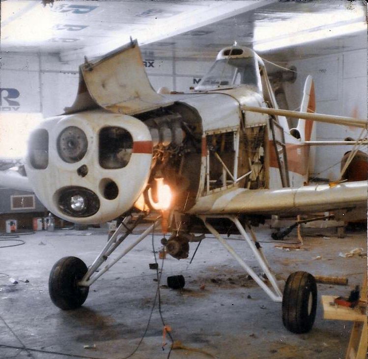
A sad sight: a mid-1990s photo of the remains of a Bridgeport hangar by Joe Gorman.
Joe recalled, “They were taken with a Yashica Mat 125G twin-lens reflex camera and black & white film.”
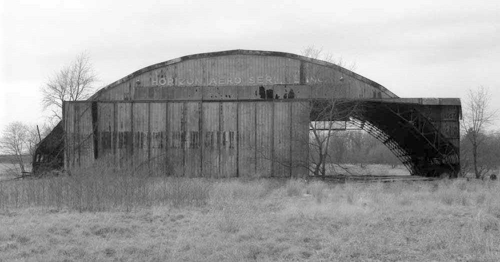
A mid-1990s photo by Joe Gorman of a Bridgeport hangar, with the lettering still visible: “Horizon Aero Service Inc.”
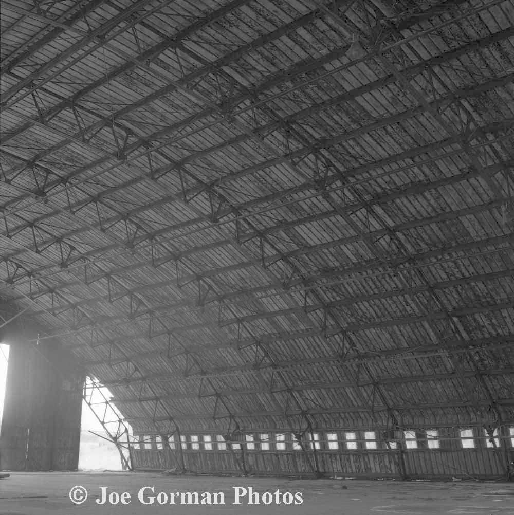
A remarkable mid-1990s photo by Joe Gorman of the interior of the Bridgeport Horizon Aero Service hangar.
According to Brad, "In the 1990-91 timeframe, there were still 2 airframes in the hangar.
One was a torn-apart fuselage for a Cessna 150 or 152,
and the other was a tube frame for some sort of fabric airplane."
According to Brad, the hangar still stood as of 1992-93,
when he used to fly radio controlled helicopters in there when the weather was bad.
"There was also an office building that appeared to be an FBO with lots of old aviation magazines & other junk in it.
That was torn down as well."
A 1997 USGS aerial view looking east showed that Bridgeport Airport's hangar had been removed at some point between 1992-97.
Charles Feldman recalled, "The big hangar that was erected was once again torn down & sold to live again somewhere else.
It had come from what was the Camden Airport."
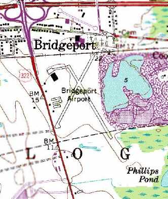
"Bridgeport Airport" was still depicted on the 1998 USGS topo map.
Note that the hangar was still depicted on the northwest corner of the property,
even though photos show it had been removed since at least 1995.
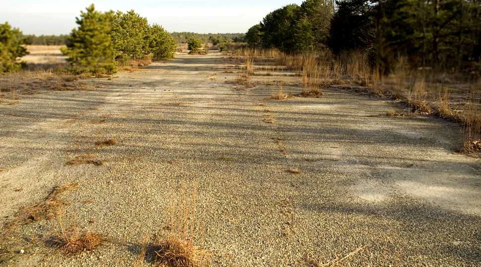
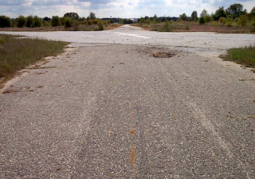
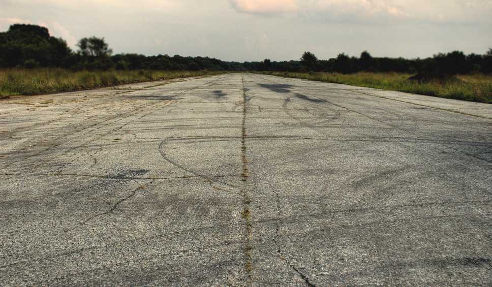
A 9/01 photo by Paul Freeman, looking south along Bridgeport's main runway.
Paul Freeman visited the site of Bridgeport Airport in 2001.
The west end of the crosswind runway runs right up to Route 322,
and there is no impediment to driving right out onto the runways.
The runways remain in fairly decent shape (aside from some cracks & potholes).
No buildings (or traces of any buildings) remain,
but the ramp at the northern end of the primary runway is sharply divided into asphalt & concrete halves,
with the southern (concrete) half having been the foundation of a hangar.
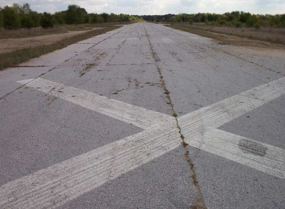
A 9/01 photo by Paul Freeman, looking west toward Route 322 at the intersection of Bridgeport's runways.
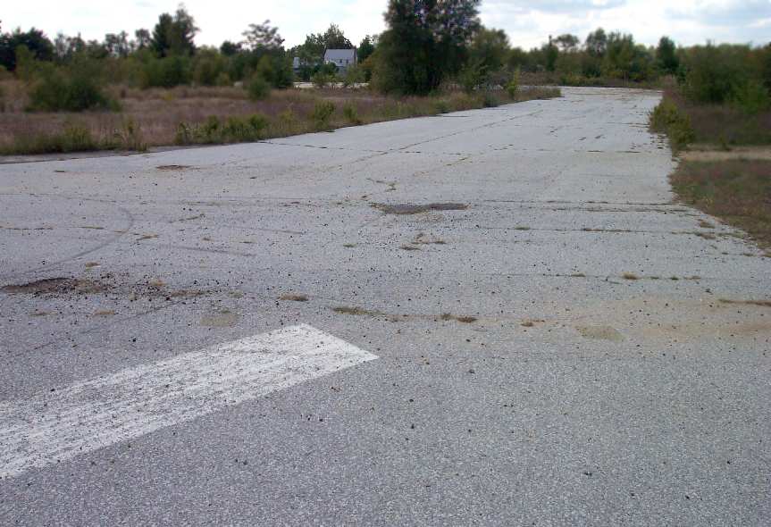
A 9/01 photo by Paul Freeman, looking west from the north end of Bridgeport's main runway along the taxiway toward the ramp.
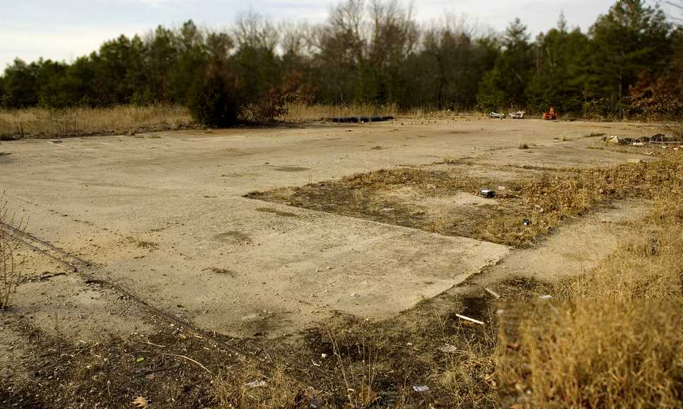
A circa 2006 aerial view looking south at the hangar foundations & runways at the site of Bridgeport Airport.
A January 2009 aerial view by Paul Freeman looking northwest at the remains of the 2 runways of Bridgeport Airport.
An 8/31/09 photo looking along the remains of a runways at Bridgeport Airport.
Jerzwolf reported in 2010, “R.E. Pierson Construction Company took over the old Bridgeport Airport,
and made it an access from US 322 to their operations area.
They put up concrete barriers & a gate along US 322.”
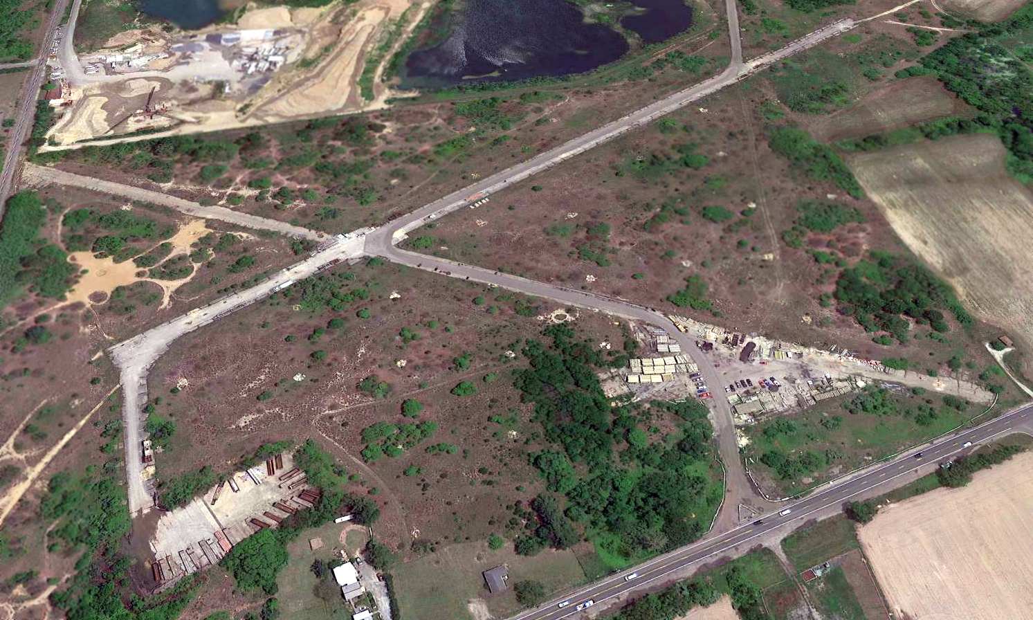
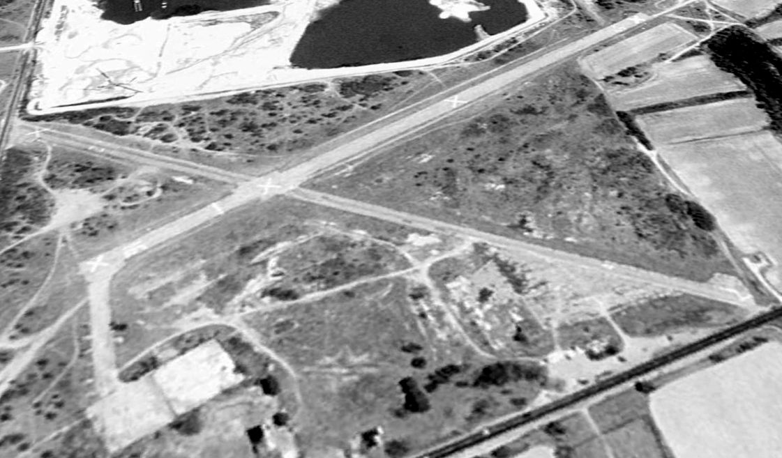
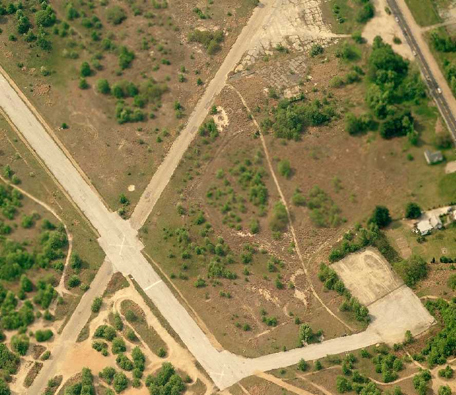
A 5/24/16 aerial view looking east at the remains of Bridgeport Airport showed the runways, taxiways, and hangar foundation remained intact.
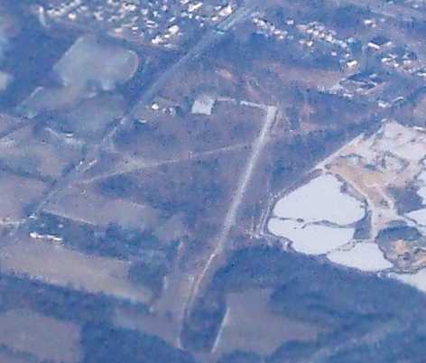
An 11/5/16 aerial view by Tony Richardson (courtesy of David Elliot) looking northwest at the remains of Bridgeport Airport.
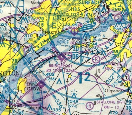
Bridgeport Airport is located immediately south of the Commodore Barry Bridge,
adjacent to the east side of Route 322.
____________________________________________________
Since this site was first put on the web in 1999, its popularity has grown tremendously.
That has caused it to often exceed bandwidth limitations
set by the company which I pay to host it on the web.
If the total quantity of material on this site is to continue to grow,
it will require ever-increasing funding to pay its expenses.
Therefore, I request financial contributions from site visitors,
to help defray the increasing costs of the site
and ensure that it continues to be available & to grow.
What would you pay for a good aviation magazine, or a good aviation book?
Please consider a donation of an equivalent amount, at the least.
This site is not supported by commercial advertising –
it is purely supported by donations.
If you enjoy the site, and would like to make a financial contribution,
you
may use a credit card via
![]() ,
using one of 2 methods:
,
using one of 2 methods:
To make a one-time donation of an amount of your choice:
Or you can sign up for a $10 monthly subscription to help support the site on an ongoing basis:
Or if you prefer to contact me directly concerning a contribution (for a mailing address to send a check),
please contact me at: paulandterryfreeman@gmail.com
If you enjoy this web site, please support it with a financial contribution.
please contact me at: paulandterryfreeman@gmail.com
If you enjoy this web site, please support it with a financial contribution.
____________________________________________________
This site covers airfields in all 50 states.