Abandoned & Little-Known Airfields:
Southwestern Michigan
© 2002, © 2016 by Paul Freeman. Revised 11/29/16.
This site covers airfields in all 50 states: Click here for the site's main menu.
____________________________________________________
Please consider a financial contribution to support the continued growth & operation of this site.
Corunna Airport (added 10/28/15) - Grand Rapids Municipal Airport / Kent County Airport (revised 11/29/16)
(Original) Hillsdale Airport (revised 4/20/14) - Morgan Field (added 11/25/16) - South Kent Airport (revised 1/30/16)
____________________________________________________
42.256, -84.71 (Southwest of Detroit, MI)
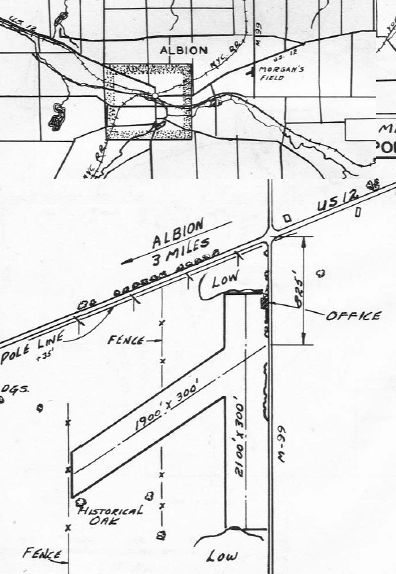
The location & layout of Morgan Field, as depicted in the 1947 MI Airport Directory (courtesy of Bill Grasha).
Morgan Field was not yet depicted on the 1942 Milwaukee Sectional Chart (courtesy of Dick Merrill).
According to the article “Morgan Field” by Frank Passic in the 11/27/94 Morning Star (courtesy of Bill Grasha),
“Albion’s airport once consisted of a 40-acre site, developed by Stanley Morgan in June 1946.
A licensed pilot & instructor, he leased the land from farmer Etril Haggit for approximately $1,500 / year.”
The airport was located southwest of M-99 & old U.S.12.
“The airport’s main office & hangar was located on Finley Road.
Morgan gave flying lessons & promoted the sport in the Albion area.
There were 2 runways. The main one ran northeast/southwest, and the secondary one north/south.
The western edge of the property was where the County Lanes bowling alley sits today.”
Frank continued, “There was a flying club called the Skyrangers, consisting of about 20 flying enthusiasts.
The group owned a 1946 Piper Cub, a 2-seat plane.
President of the club was Albion postmaster Frank Sibal, Secretary was William Bunn, with Hubert Gaskell as Treasurer.”
Frank continued, “There were 8 planes based at Morgan Field,
which included 2 light craft assigned to the MI National Guard’s 943rd Field Artillery Battalion under the command of Lt. Colonel Noble Moore.
The Guard paid $480 annually in rent to use the facilities, which helped in the overall rent costs of the land.”
The earliest dated depiction which has been located of Morgan Field was in the 1947 MI Airport Directory (courtesy of Bill Grasha).
It depicted Morgan Field as having 2 unpaved runways, measuring 2,100' north/south & 1,900' northeast/southwest.
An office was depicted on the northeast corner.
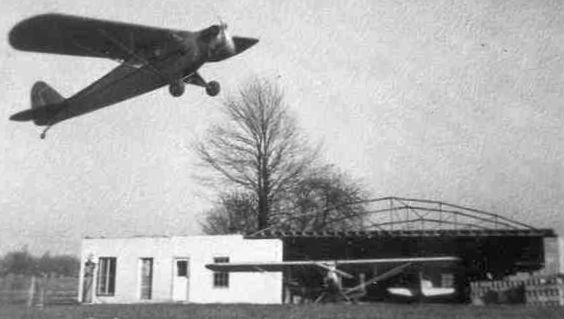
A circa 1946-51 photo (courtesy of Bill Grasha) of a Piper Cub overflying a the Morgan Field office on Finley Road, with an adjacent hangar under construction.
According to the article “Morgan Field” by Frank Passic in the 11/27/94 Morning Star (courtesy of Bill Grasha),
“In March 1950, Mr. Morgan was unable to individually bear the burden of the rent costs for the land, then amounting to $1,500 a year.
So the local Skyrangers began a subscription drive & raised the money themselves.
Albion’s 5 major industries donated funds, as well as numerous merchants.
Morgan continued to operate the facility as its manager on a sub-lease basis.”
Frank continued, “On year later however in March 1951,
it was announced that the Skyrangers were unable to raise all the funds to rent the land for another year, and that the Morgan Field would be closed.
The club announced it was selling its plane to pay off a $300 indebtedness on its lease.
Apparently, local industries were able to pay their share of the $1,500 annual rental price, but donations from merchants fell short.
The Skyrangers also announced that they were disbanding their club at the time.
Plea's by the city to keep the field open failed. The National Guard planes were moved to Brooks Field in Marshall.
Skyranger officials remarked at the time that few people realized the extent to which Morgan Field had been used
by industrial executives & salesmen coming to visit Albion manufacturing plant offices.
At least 2 planes a day were arriving for that purpose during the spring, summer, and fall seasons.”
Frank continued, “Amberton village, the Bowling Alley, and other enterprises were built on the former airport site, and this unique opportunity was lost forever.
Industrialists coming to Albion now have to fly into other airports & make a half-hour drive to get here.”
Morgan Field was no longer depicted on the 1958 USGS topo map.
No trace remained of Morgan Field in a 1998 USGS aerial photo.
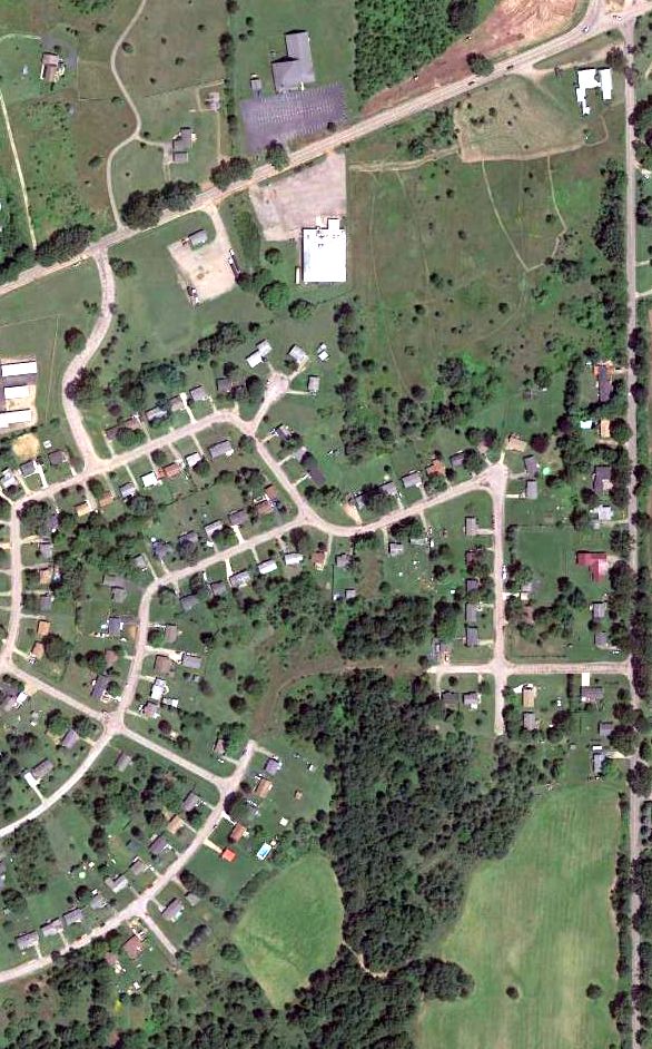
A 2015 aerial view showed no trace remaining of Morgan Field.
The site of Morgan Field is located southwest of the intersection of Finley Road & Michigan Avenue.
Thanks to Bill Grasha for pointing out this airfield.
____________________________________________________
43.04 North / 84.01 West (Northwest of Detroit, MI)
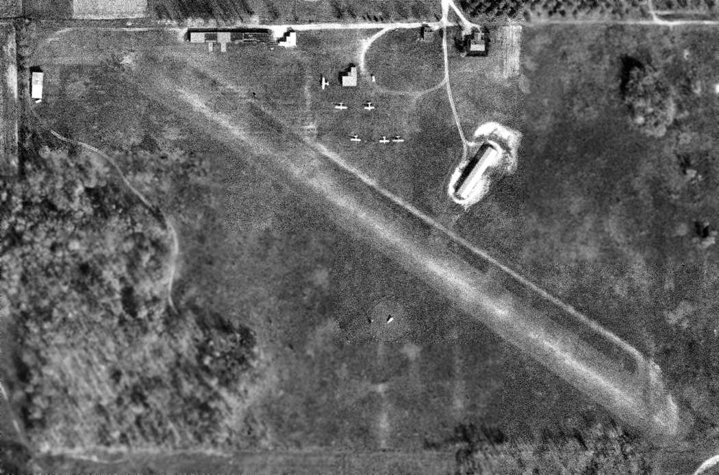
A 4/21/98 USGS aerial view looking southeast at Corunna Airport.
Not much is known about this small general aviation airport, including its name or date of construction.
It was not yet depicted on USGS topo maps from the 1970s or 1980s.
The earliest depiction which has been located of Corunna Airport was a 4/21/98 USGS aerial view.
It depicted Corunna Airport as having a single unpaved northeast/southwest runway,
with a few small buildings on the north side of the field.
Jason Morford recalled, “The airport was a privately-owned, public [use] airport.
The metal barn on the left is a hangar. I think there was a Stearman based there.”
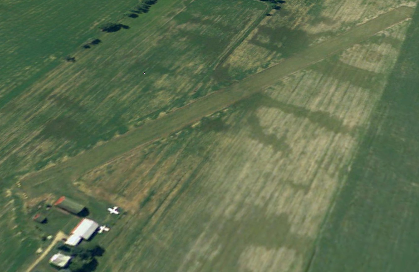
The only photo which has been located showing aircraft at Corunna Airport was a 4/31/05 aerial view looking southeast.
It showed 2 light single-engine aircraft parked next to the hangar.
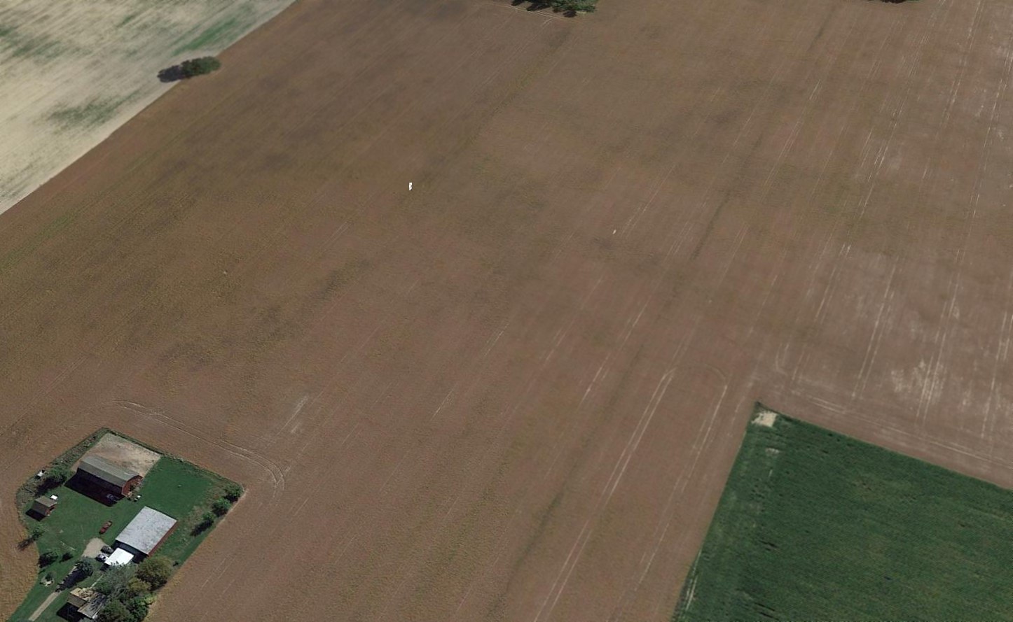
The last photo which has been located showing the Corunna Airport runway appearing to still be maintained was a 5/31/09 aerial view looking southeast.
But there were no aircraft visible on the field.
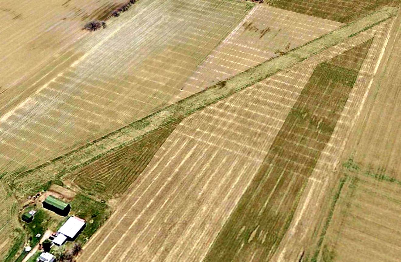
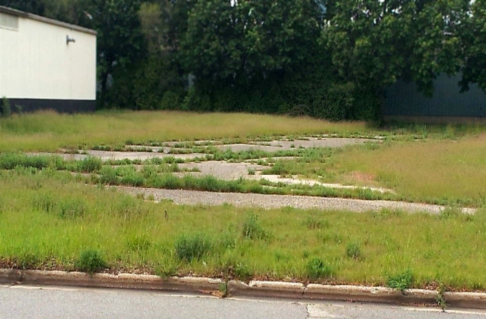
Corunna Airport had evidently been closed (for reasons unknown) by 2011,
as a 6/1/11 aerial view showed that the runway had been plowed over, but was still somewhat recognizable.
A 9/26/14 aerial view showed that only the faintest trace was remaining of the Corunna Airport runway,
although the hangar still remained on the north side of the airport site.
As of 2015, street maps still show a single northeast/southwest runway, even though contemporary aerial photos show the runway to be long-gone.
The site of Corunna Airport is located southeast of the intersection of Cronk Road & North Reed Road.
Thanks to Jason Morford for pointing out this airfield.
____________________________________________________
South Kent Airport, Grand Rapids, MI
42.84 North / 85.69 West (Northwest of Detroit, MI)
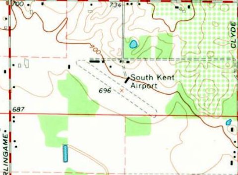
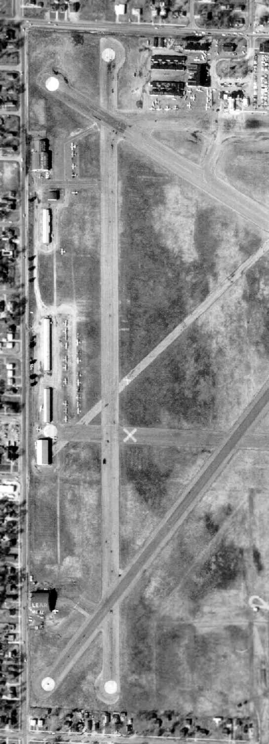
An 11/1/65 USGS aerial view of South Kent Airport.
This small general aviation airport on the south side of Grand Rapids may have been established at some point between 1950-65,
as it was not yet depicted on the 1950 USGS topo map.
The earliest depiction which has been located of South Kent Airport was an 11/1/65 USGS aerial photo.
It depicted South Kent Airport as having a single unpaved northwest/southeast runway,
with several T-hangars & 6 single-engine aircraft on the north side of the field.
The 1967 USGS topo map depicted South Kent Airport as having a single unpaved northwest/southeast runway,
and several T-hangars on the north side of the field.
The only aeronautical chart depiction which has been located of South Kent Airport
was on the May 1970 Milwaukee Sectional Chart (courtesy of Alex Hauzer).
It depicted South Kent Airport as having a 2,200' unpaved runway.
Gary Norton recalled, “South Kent is where I learned to fly in a Cessna 140 [in 1972].
Note it is a bumpy grass strip with a fence at each end of the runway; a tree line & parked airplanes, gas pumps, and buildings next to the runway.
This, coupled with a student pilot in a taildragger, should send goose bumps through pilots who understand these parameters.
Also, Calvin Molyneux was my father-in-law & an Army Air Force taught, hard-nosed instructor. This scenario was cause for extreme stress on my part.
I can’t tell you how many times it took me to learn to takeoff without Calvin’s help.
I know he had 3 persons to teach how to fly, and his patience was usually pretty short.
He had to force our minds to use right rudder to overcome the corkscrewing slipstream of air from the propeller.”
Gary continued, “Once we were in the air, we had to learn to land.
This is not the case for pilots who have 5,000' long concrete runways.
I had to learn how to land on an 1,800', fence-to-fence grass strip.
Not only was this a short field, there was a Big Red Barn when turning final for Runway 31.
One of the first maneuvers we learned to accomplish was to fly a perfect pattern. I emphasize perfect.
Calvin would not allow me to deviate 25' altitude or 0 degree direction. All corners had to be square & distances on the numbers.
I had to learn how to slip the Cessna while in final because of the trees & the aforementioned Big Red Barn.
Also, the Cessna 140 has a slippery shape & is difficult to slow.
Therefore, the landing speed has to be controlled & in a cross-controlled condition, you lose altitude while not gaining speed.
I was warned to be careful in a windy crosswind condition, because when you are cross-controlled, you have little room for correction.
Once safely on the ground, Calvin warned me to not lose concentration on landing the plane.
A characteristic of a tail dragger is a tendency to ground loop. I remember Calvin telling me that I should not finish landing until the Cessna was tied down.”
Gary continued, “South Kent Airport was managed by Roland Palma, and he owned the Fixed-Base Operator, Palma Aviation.
He was wary of us & once, as I was standing near him watching Evan go for a lesson, I heard him say, 'I am just waiting for one of you to kill yourselves.'
He really meant it from the tone of his voice & I never had an occasion to be his friend.”
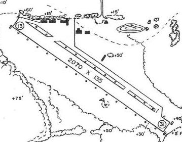
A circa 1985 MI Airport Directory (courtesy of Gary Norton)
depicted South Kent Airport as having a single 2,070' Runway 13/31, with several small hangars along the north side.
The manager was listed as Palma.
Unfortunately, it also noted that the airport was scheduled for closure in the Summer of 1989.
The 1991 USGS topo map continued to depict South Kent Airport.
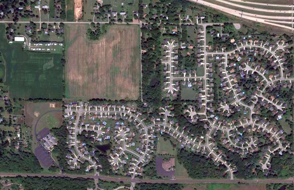
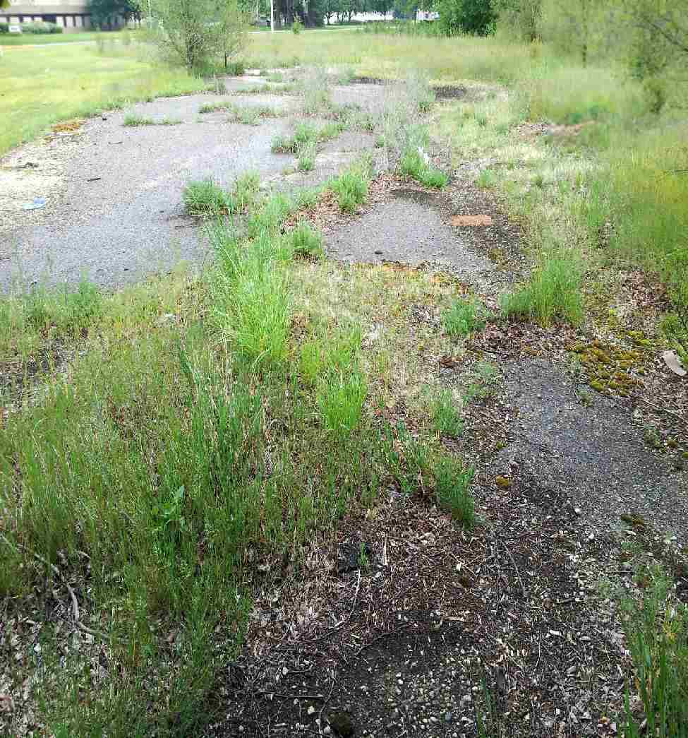
A 1999 aerial photo showed that a housing development had covered the site of South Kent Airport,
with no recognizable trace remaining of the small airport.
An 8/22/13 aerial view showed no trace remaining at the site of South Kent Airport.
As of 2014, street maps show that the site of South Kent Airport is commemorated by the names of several of the residential streets which replaced the airport,
including Airfield Drive & Runway Drive.
Thanks to Gary Norton for pointing out this airfield.
____________________________________________________
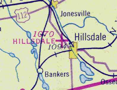
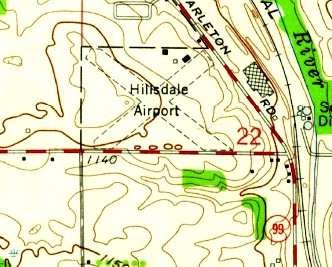
(Original) Hillsdale Airport, Hillsdale, MI
41.94 North / 84.65 West (West of Detroit, MI)
Hillsdale Airport, as depicted on the May 1942 Chicago Sectional Chart (courtesy of Chris Kennedy).
The original Hillsdale Airport was located adjacent to the northwest side of the town.
The Hillsdale Airport may have been established at some point between 1937-38,
as it was not yet listed among active airfields in the Airport Directory Company's 1937 Airports Directory (courtesy of Bob Rambo).
The earliest reference to the Hillsdale Airport which has been located
was in the Airport Directory Company's 1938 Airports Directory (courtesy of Chris Kennedy).
It described Hillsdale as an auxiliary airfield, with 2 runways in a cross-shape:
1,900' northwest/southeast & 1,800' northeast/southwest.
The earliest depiction of the Hillsdale Airport which has been located
was on the May 1942 Chicago Sectional Chart (courtesy of Chris Kennedy).
It depicted Hillsdale as an auxiliary airfield.
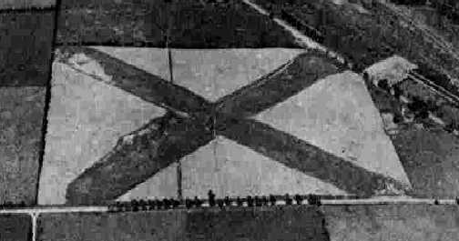
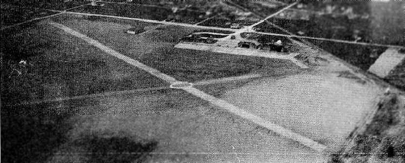
The only photo which has been located showing of Hillsdale Airport in operation was a 9/19/43 aerial view looking north
from the 1945 AAF Airfield Directory (courtesy of Scott Murdock).
It depicted Hillsdale as having 2 grass runways in an X-shape.
The June 1944 U.S. Army & Navy Directory of Airfields (courtesy of Joe Benson)
described Hillsdale as having a 1,900' unpaved runway.
The 1945 AAF Airfield Directory (courtesy of Scott Murdock) described Hillsdale Municipal Airport
as a 50 acre irregularly-shaped property within which were 2 gravel & sod runways: 1,900' northwest/southeast & 1,800' northeast/southwest.
The field was not said to have any hangars,
to be owned by the City of Hillsdale, and to be operated by private interests.
According to a 1976 book published by the Hillsdale County Historical Society & the Hillsdale County Bicentennial Commission (via Michael Goble),
one evening late in the Fall of 1945, a group of 75 or 80 aviation & flying enthusiasts met to talk about organizing a Hillsdale Aviation Club.
The first president of the new organization was Bernard "Bud" Richard, an experienced pilot & flying enthusiast.
During the first year, the monthly meetings were devoted to planning & financing a clubhouse for a meeting place.
The first "Dawn Patrol" sponsored by the new club was in 1946,
and with the exception of 2 years, this has become an annual event.
With money obtained from the profits of this event,
materials were purchased for a clubhouse & office for the airport
while the members held "work bees" doing all the labor required to build a modest sized office, meeting room, and restrooms.
The earliest operator was Lloyd Brown, with Guy Pearce as instructor.
He was followed by Francis Clymer & Russell King.

The most detailed depiction of the Hillsdale Airport which has been located
was in the 1946 MI Airport Directory (courtesy of Doug Ranz).
It depicted the field as having 2 unpaved runways (1,900' northwest/southeast & 1,800' northeast/southwest),
with a hangar & office at the northeast corner of the field.
An undated (circa late 1940s?) aerial view looking north at Hillsdale Airport (courtesy of Jeff King)
showed 2 single-engine aircraft next to a ramp with 2 hangars, on the north side of a grass airfield.
Many of the students at Hillsdale were veterans, using their benefits to pay for flying lessons.
When this source of revenue began to dry up, no one wanted to manage & operate the airport.
The city had about decided to abandon it & put it back into farmland
but at this point, to avoid closing down altogether, the Aviation Club stepped in
and agreed to keep telephone, restrooms & a supply of gasoline available.
By the late 1950s the inadequacy & poor approaches of the "old" field become more & more apparent.
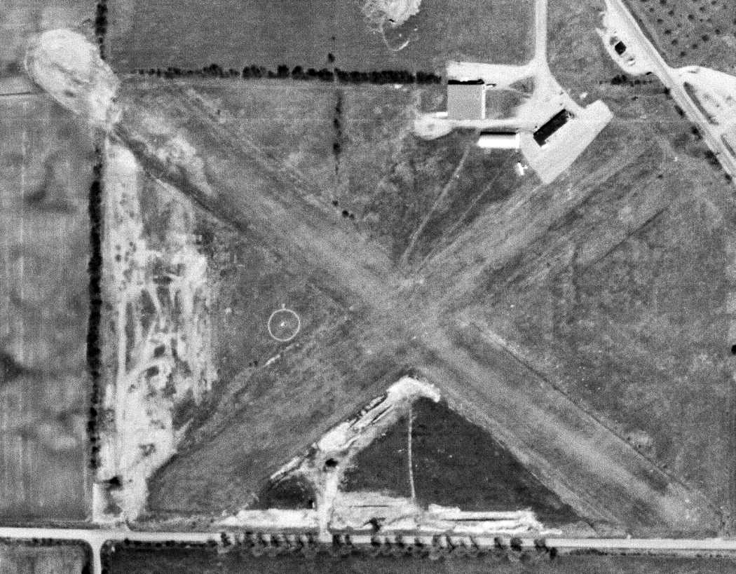
The last photo which has been located of Hillsdale Airport was a 4/25/58 USGS aerial view,
which depicted only 1 single-engine aircraft visible parked outside on the north side of the field.
The 1959 USGS topo map (courtesy of Mike Denja) depicted Hillsdale Airport as having 2 unpaved runways,
with 2 buildings on the north side.
The 1962 AOPA Airport Directory described Hillsdale Municipal
as having 2 sod runways (1,900' Runway 13/31 & 1,800' Runway 4/22).
The last depiction which has been located of the original Hillsdale Airport was on the 1962 USGS topo map.
The original Hillsdale Airport was apparently replaced within the next year
by a new Hillsdale Municipal Airport 2 miles to the east of the town,
as only the new field was listed in the 1963 AOPA Airport Directory (according to Chris Kennedy).
The property of the original Hillsdale Airport was sold & was eventually redeveloped as an industrial park.
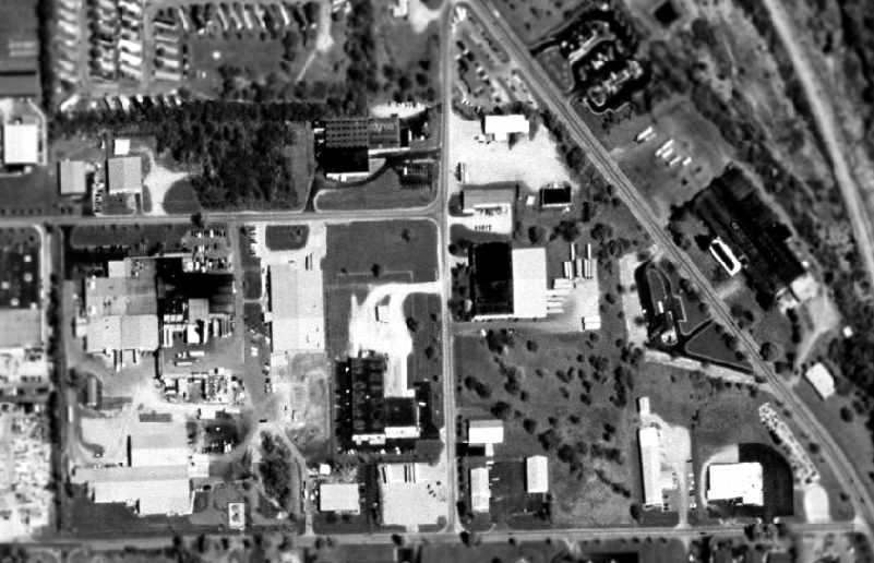
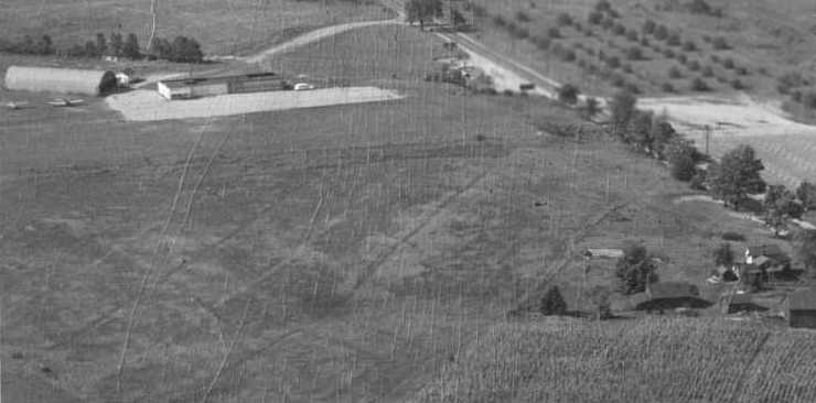
As seen in the 1998 USGS aerial photo,
no obvious traces of the original Hillsdale Airport appears to remain.
However, Keith Wood pointed out a faint remaining trace of the former airport -
the row of trees running southeast from the center of the photo matches the southern edge of the former northwest/southeast runway.
The site of the original Hillsdale Airport is located northwest of the intersection of Route 99 & Mechanic Road.
Thanks to Michael Goble for pointing out this former airfield.
____________________________________________________
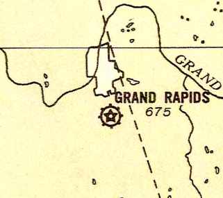
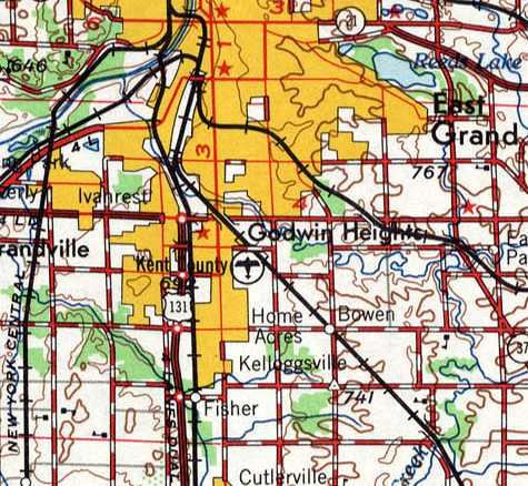
Grand Rapids Municipal Airport / (Original) Kent County Airport, Grand Rapids, MI
42.9 North / 85.65 West (Northwest of Detroit, MI)
An aerial view looking northwest at Grand Rapids Municipal Airport
from The Airport Directory Company's 1933 Airports Directory (courtesy of Chris Kennedy).
As described on the web site of the current Grand Rapids Airport,
groundbreaking for Kent County's first airport took place in 1919,
on a site 4 miles from downtown Grand Rapids.
The United States' first regularly scheduled airline service began in 1926, between Grand Rapids & Detroit.
In 1927, Charles Lindbergh landed the Spirit of St. Louis at Kent County Airport.
This visit came only a few months after his historic New York-to-Paris flight.
With an infusion of federal funds, the airport took on a new look in the 1930's.
WPA money was used to remodel the Administration building & build a new restaurant.
In 1930, the Kent County Board of Supervisors appointed one of its own, Tom Walsh, to manage the airport.
Tom Walsh's years of service to the airport would span almost thirty years & leave a lasting legacy.
The Airport Directory Company's 1933 Airports Directory (courtesy of Chris Kennedy)
described Grand Rapids Municipal as having two 2,900' asphalt runways.
The aerial photo in the directory depicted a ramp with several hangars.
The Manager was listed as T. E. Walsh,
and the operators were listed as Furniture Capitol Air Service & Kohler Aviation Corporation.
Grand Rapids Airport, as depicted on the 1935 9M Night Flying Chart.
The Airport Directory Company's 1938 Airports Directory (courtesy of Chris Kennedy)
described Grand Rapids Municipal as having 4 sod runways,
with the longest being the 2,700' northeast/southwest & northwest/southeast strips.
A 1938 aerial photo of Grand Rapids Airport (courtesy of Tom Byle),
shows the field's preWW2 configuration, with a number of runways in a roughly square-shaped plot of land.
However, it can be seen that construction was underway to extend the northwest/southeast runway
into a newly annexed plot of land to the southeast.
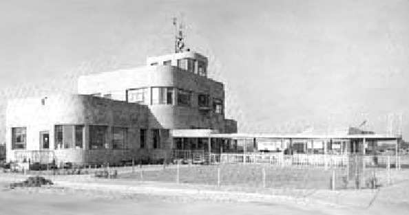
An undated photo of the new Administration building, which was completed in 1939.
It boasted the very latest heating, lighting, plumbing, and all modern conveniences of the time.
The building's 24" thick, steel-reinforced concrete walls were built to be "bomb proof".
In 1940, Grand Rapids was one of only six American cities boasting scheduled air service north, south, east, and west.
WW2 military needs in the early 1940s led to the addition of several buildings at the airport.
Because it fulfilled all requirements for night lighting,
the airport was a useful place early in the war to train transport pilots & to conduct training exercises.
The first pilot cadet training program in Michigan began at Kent County Airport in 1942.
Hundreds of military pilots eventually received their primary & advanced flight & ground school instruction
at the field over the next 2 years.
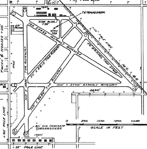
The 1945 AAF Airfield Directory (courtesy of Scott Murdock) described Kent County Airport
as a 324 acre irregularly-shaped property within which were 5 runways, with the longest being a 4,420' northwest/southeast concrete strip.
The field was said to have a total of 22 concrete hangars, ranging in size up to 120' x 60',
and to be owned & operated by Kent County.
The 1946 MI Airport Directory (courtesy of Doug Ranz)
depicted the Kent County Airport as having a total of 5 asphalt or tar runways,
with the longest being the 4,400' southeast/northwest runway.
All-cargo air freight service came to Grand Rapids in 1946,
and in 1947 a new $60,000 control tower began operating atop the Administration building.
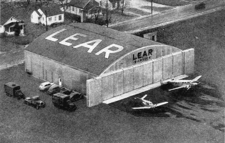
An undated aerial photo looking northwest at the Lear hangar along the southwest side of Grand Rapids Airport (courtesy of William Willyard),
from the back cover of the 1948 Lear Annual Report.
A V-tail Bonanza & a Beech 18 are parked in front of the hangar marked “Lear Service”.
Kent County Airport, as depicted on the 1949 Milwaukee Sectional Chart (courtesy of Donald Felton).
By 1949 the airport's facilities were strained to the maximum,
and the citizens of Kent County voted to expand the airport at its current location,
which would require the purchase of 120 acres & 89 houses.
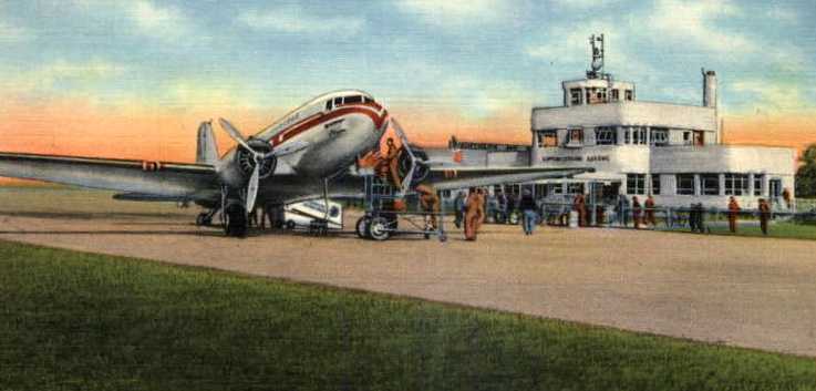
A colorized circa 1940-50s photo of a DC-3 unloading in front of the Kent County terminal.
In early 1952 the newly expanded 5,700' runway was completed.
For a time, movable gates were necessary to keep 44th Street traffic
from crossing the airport's longest runway while planes were taking off & landing.
A 1954 aerial photo of Grand Rapids Airport (courtesy of Tom Byle) depicted the airport's new configuration,
with the new concrete Runway 18/36 extending over a significantly larger plot of land toward the south.
A hangar on the north side of the field said "Lear Northern Service" on the roof,
as well as another small hangar marked with "Lear" on the southwest side of the field.
Land had been cleared on the southeast side of the field for the new Lear factory,
but the buildings had not yet been constructed.
By 1956, increased air travel resulted in the airport again bursting at the seams.
In 1957 the Aeronautics Board hired an aviation consultant to conduct a study exploring which option was more feasible:
to expand & improve the existing airport or to start over on a new site.
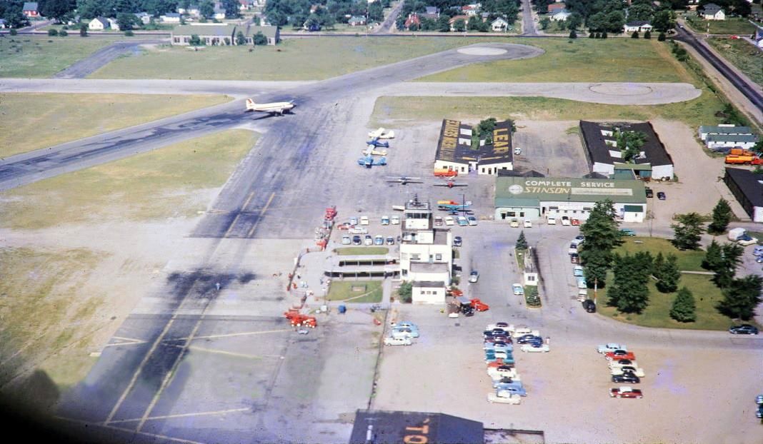
A circa late 1950s aerial view looking west at the northwest corner of Grand Rapids Municipal Airport (courtesy of Dave Thompson).
Dave Thompson observed, “The photo is looking west at the north end of Runways 18 & 12, with the terminal building in the foreground and the 'new' Lear hangars further west.
Also a cool shot of the Stinson hangar. A United Airlines DC-3 appears to be taxiing off of Runway 30.”
Kent County Airport, as depicted on the 1958 USGS topo map.
In 1958 the decision was made to replace the original airport with a newly constructed field in eastern Cascade Township.
The groundbreaking was conducted for the new field in 1961.
USAF Lt. Col. Mark Bailey recalled, "I flew in United DC-6's out of the old [Kent County] airport
to Chicago many times as a youngster in the 1960s.
My father also flew in North Central DC-3's out of the airport as well."
By the time of the 1962 AOPA Airport Directory,
the original Kent County Airport was in its final year of operation.
It was described as having a 5,700' concrete Runway 18/36,
a 4,400 asphalt Runway 12/30, and a 3,400' asphalt Runway 4/22.
The operators were listed as Northern Air Service (Cessna) & Grand Rapids Aviation (Beechcraft),
and airline service was listed as being provided by Lake Central, North Central, and UAL.
A March 1963 aerial photo of Grand Rapids Airport (courtesy of Tom Byle),
taken only a few months before the field closed.
It shows the original runway layout at the north end of the field,
as well as the newer concrete Runway 18/36 which extended toward the south.
"You can see where the long runway crossed 44th Street & they closed gates to let planes land & take off.
The taxiway to the east off the long north/south runway went to the Lear plant."
A close-up from the March 1963 aerial photo of the west side of Grand Rapids Airport (courtesy of Tom Byle),
Tom observed, “The furthest south hangar on the west side said 'Lear' on the roof.”
It was evidently a facility of Bill Lear, who went on to produce the Lear Jet.
The final transfer of all Kent County air service took place in 1963,
and the original Kent County Airport closed in November 1963 (according to Grand Rapids resident Tom Byle).
By the time of the 1967 Milwaukee Sectional Chart (courtesy of Chris Kennedy),
the site of the original Kent County Airport was labeled as "Abandoned airport".
According to Tom Byle, "All the hangars were on the north & west sides of the field
but were demolished to make way for the industrial park."
The site of the former airport was labeled "Kent Industrial Center on the 1981 UGSS topo map.
USAF Lt. Col. Mark Bailey observed, "The old airport now is an industrial park.
I last saw it 20 years ago [in the 1980s] and some pavement still existed."
Grand Rapids resident Tom Byle reported in 2004 that none of the original airfield buildings or hangars still exist.
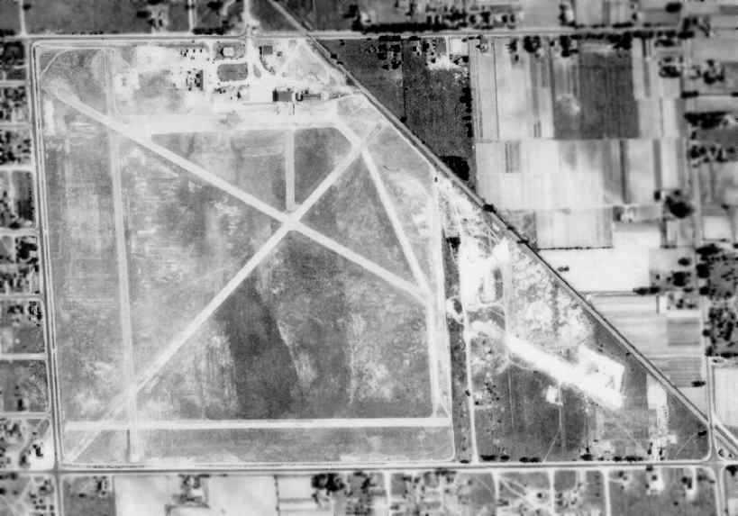
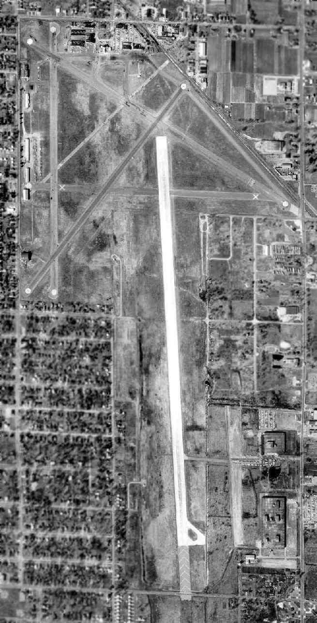
As can be seen in the 2005 USGS aerial photo,
the site of the former Kent County Airport has been heavily redeveloped with industrial buildings.
However, more than half of the former runways have been reused as streets or industrial backlots.
The most obvious of these is the former Runway 18/36 & its parallel taxiway,
which have been reused as a street - Roger B Chaffee Memorial Drive SE.
Jim Saltsman reported in 2006 that he was “able to find (& stand on) portions of the original northwest/southeast runway.”
An April 2012 photo by Andrew Roberts, “part of a taxi strip heading northeast to southwest right where it connects to the original northwest to southeast runway.”
An April 2012 photo by Andrew Roberts, “of part of the original northwest to southeast runway. This area is just off Roger B. Chaffee Boulevard after 32nd Street.”
An April 2012 photo by Andrew Roberts, of “Roger B. Chaffee Boulevard at 36th Street, which was the large north/south runway.
There are a few other places where the original asphalt runways still exist for this airport, however, they are inaccessible because they are on private property.”
The site of Kent County Airport is bounded by Jefferson Street Southeast to the west, Eastern Avenue to the east,
44th Street Southeast to the south, and 32nd Street Southeast to the north.
Thanks to USAF Lt. Col. Mark Bailey for pointing out this former airfield.
____________________________________________________
Since this site was first put on the web in 1999, its popularity has grown tremendously.
That has caused it to often exceed bandwidth limitations
set by the company which I pay to host it on the web.
If the total quantity of material on this site is to continue to grow,
it will require ever-increasing funding to pay its expenses.
Therefore, I request financial contributions from site visitors,
to help defray the increasing costs of the site
and ensure that it continues to be available & to grow.
What would you pay for a good aviation magazine, or a good aviation book?
Please consider a donation of an equivalent amount, at the least.
This site is not supported by commercial advertising –
it is purely supported by donations.
If you enjoy the site, and would like to make a financial contribution,
you
may use a credit card via
![]() ,
using one of 2 methods:
,
using one of 2 methods:
To make a one-time donation of an amount of your choice:
Or you can sign up for a $10 monthly subscription to help support the site on an ongoing basis:
Or if you prefer to contact me directly concerning a contribution (for a mailing address to send a check),
please contact me at: paulandterryfreeman@gmail.com
If you enjoy this web site, please support it with a financial contribution.
please contact me at: paulandterryfreeman@gmail.com
If you enjoy this web site, please support it with a financial contribution.
____________________________________________________
This site covers airfields in all 50 states.