Abandoned & Little-Known Airfields:
Maryland: Central Prince George's County area
© 2002, 2016 by Paul Freeman. Revised 8/18/16.
This site covers airfields in all 50 states: Click here for the site's main menu.
____________________________________________________
Please consider a financial contribution to support the continued growth & operation of this site.
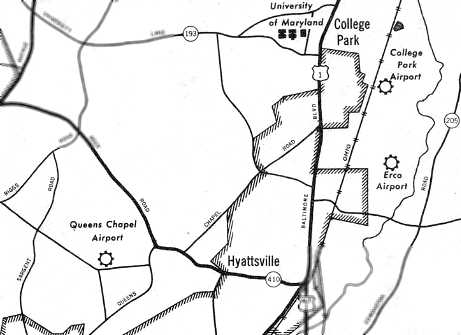
For a suburban community, Prince George's County has a remarkable aviation heritage.
A total of 10 airfields within the county are profiled on this web site (many of which have historic value).
Unfortunately, the county's proud aviation heritage is not very widely known.
Capitol Airport (1st location) (revised 7/9/04) - ERCO Field (revised 8/18/16)
Queen's Chapel Airport (revised 12/3/11) - Skyhaven Airport (added 3/21/09)
____________________________________________________
Skyhaven Airport, Suitland, MD
38.85 North / 76.93 West (East-southeast of Washington, DC)
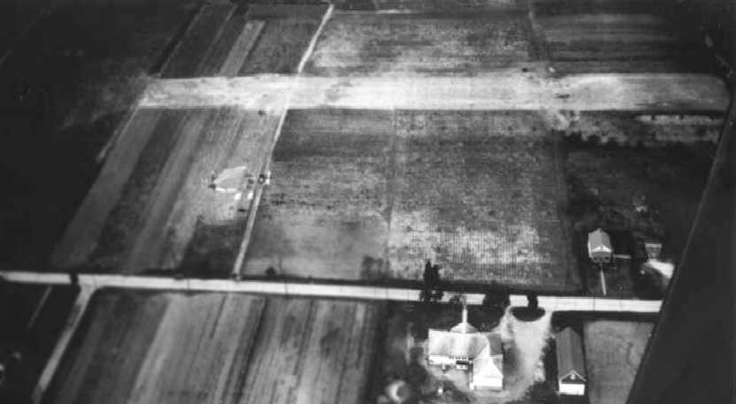
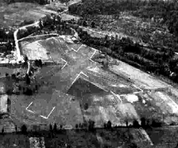
A circa 1937 aerial view looking northwest at the start of runway construction at Skyhaven Airport.
The intersection of Swann Road & Silver Hill Road is visible.
This little general aviation airport had the bad luck to be founded in the late 1930s,
on property that would soon be eaten up by federal government office building construction.
According to the Census Bureau website, James West & Joseph Friday were the owners of Skyhaven Airport.
The earliest photo which has been located of Skyhaven Airport was a circa 1937 aerial view looking northwest,
showing the start of construction of a single northeast/southwest runway, paralleling Silver Hill Road.
The airport’s owners allowed local school children to enter a contest to name the field.
“Skyhaven” was chosen, and the lucky student who suggested it received a first prize of $25.
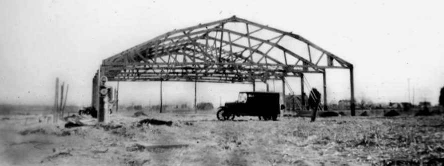
A circa 1937-38 photo of a hangar under construction at Skyhaven Airport.
Several plane crashes in 1937 & 1939 were reported in the Washington Post,
including one that resulted in the death of a 20-year old aspiring transport pilot
whose second-hand biplane spun into the ground at Skyhaven while he executing a vertical turn over the field.
A representative of the Air Safety Board examined the plane immediately after the accident
and reported that no engine or structural damage could be determined,
but that the license numbers had already been partially stripped away by souvenir seekers.
It was home to a flying club, serving about 20 small planes in 1938, including Wacos, Great Lakes, Cubs, and Pipers.
In February 1938, legislation introduced by Rep. Reuben Wood (D-MO) suggested Suitland as a site for a new National Capital airport,
competing with several other locations in the metropolitan area.
The Airline Pilots Association & other groups suggested the site in testimony before the Public Buildings & Grounds Committee later that month.
In May 1938, Skyhaven Airport was the site of the largest powered model airplane contest ever held in the Mid-Atlantic.
More than 250 model airplanes, powered by ¼-horsepower engines & capable of speeds up to 55 MPH, took part in the 2-day meet.
One of the winners was Carrol Carter of Northeast Washington, whose model plane had an average flight time of 4.5 minutes.
The Airport Directory Company's 1938 Airport Directory (courtesy of Chris Kennedy)
described Skyhaven as a commercial airport having 2 sod runways,
measuring 2,500' northeast/southwest & 1,700' northwest/southeast.
A hangar was said to have “Skyhaven Washington DC” on the roof.
In the fall of 1938, President Roosevelt, "tired of waiting for Congress" to select a site for Washington's new airport,
declared that the airport would be built on mudflats on a bend of the Potomac River at Gravelly Point, 4.5 miles south of Washington, DC,
thus ending Skyhaven's contention in the selection for what would eventually become Washington National Airport.
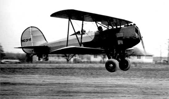
A 1939 photo of an unidentified biplane landing at Skyhaven Airport.
Curiously, Skyhaven Airport was not depicted on the 1939 or 1940 Washington Sectional Aeronautical Charts.
Skyhaven Airport lasted less than 4 years, as the property was acquired by the Federal Government in 1941
for the construction of Federal Office Building 3 (FOB-3), to be used by the Census Bureau.
The operation of the airport presumably ended at that point.
A 1949 aerial view showed no remaining trace of the airport,
with the site covered by the federal government office buildings.
A June 6, 2007 aerial view shows the Census Bureau buildings covering the site, with not a trace remaining of the former Skyhaven Airport.
The site of Skyhaven Road is located northwest of the intersection of Swann Road & Silver Hill Road.
The immediate area retains an important aviation role,
as the Smithsonian Air & Space Museum's Paul E. Garber Restoration & Storage Facility
is located less than a mile to the west along Silver Hill Road.
Thanks to Fred Sanford for pointing out this airfield.
____________________________________________________
Capitol Airport (1st location), Bladensburg, MD
38.93 North / 76.93 West (East-northeast of Washington, DC)
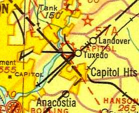
The first location of Capitol Airport, as depicted on the 1935 Washington Sectional Chart.
Capitol Airport was evidently established at some point between 1932-33,
as it was not yet depicted on the May 1932 J-18 Washington D. C. Airway Map (courtesy of Chris Kennedy).
According to the book "Maryland Aloft" by Preston, Lanman, and Breilhan,
a paper by Karin Thiessen gives Capitol Airport's original location in Bladensburg as "near the Peace Cross,
on River Road between Bladensburg Road & Kenilworth Avenue.
Thiessen states that the facility was owned by Edward Stitt,
who operated it with his wife Evelyn, at least as early as 1933."
Capitol Airport was depicted on a 1934 Sectional Aeronautical Chart (according to "Maryland Aloft").
The 1935 Regional Aeronautical Chart (courtesy of Scott O'Donnell)
depicted Capitol Airport as a commercial or municipal airport, directly south of College Park Airport.
A 1936 Department of Commerce Bulletin described Capitol Airport as having two runways (1,400' & 1,200'),
as well as at least one hangar.
The Airport Directory Company's 1937 Airports Directory (courtesy of Bob Rambo)
listed Capitol Airport at its Bladensburg location.
It described the field as consisting of two runways,
with the longest being a 1,400' north/south strip.
According to the book "Maryland Aloft",
"Among the aviators using the field in its heyday was famed transatlantic pilot & barnstormer Clarence Chamberlain,
who offered aerial rides to the public."
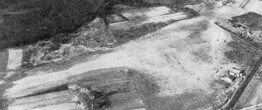
An aerial view looking north at the Bladensburg location of Capitol Airport,
from The Airport Directory Company's 1941 Airport Directory (courtesy of Chris Kennedy).
The field was described as being located 1 mile south of Bladensburg
and 5 miles northeast of the Capitol Building.
The field was said to have two gravel runways: 2,400' north/south & 1,800' northwest/southeast,
with a road running along the east side, and a railroad to the northeast.
Two small buildings (hangars?) were depicted along the road on the east side of the field.
Capitol Airport was owned by Horace Thompson,
according to Keith Lippincott, who spoke to Doug Thompson (the son of Horace Thompson).
Capitol Airport was still depicted at its Bladensburg location
on the November 1941 Washington Sectional Chart (courtesy of Chris Kennedy).
According to the book "Maryland Aloft",
the last Sectional Chart to depict Capitol Airport at its Bladensburg location was dated November 1941.
Thiessen stated that Mr. Stitt joined the military at the start of WW2,
which was evidently the reason for the field's closure.
Capitol Airport was no longer depicted at all on the 1942 Washington Sectional Chart (courtesy of Mike Keefe).
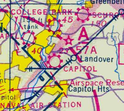
Capitol Airport apparently reopened after the war at a new location in College Park (6 miles to the north),
as that is where "Capitol" Airport was depicted on the 1945 Washington Sectional Chart (courtesy of John Voss).
A 1957 aerial photo showed that new roads & buildings had covered the site of the former Capitol Airport,
and not a trace appeared to remain of the former airport.
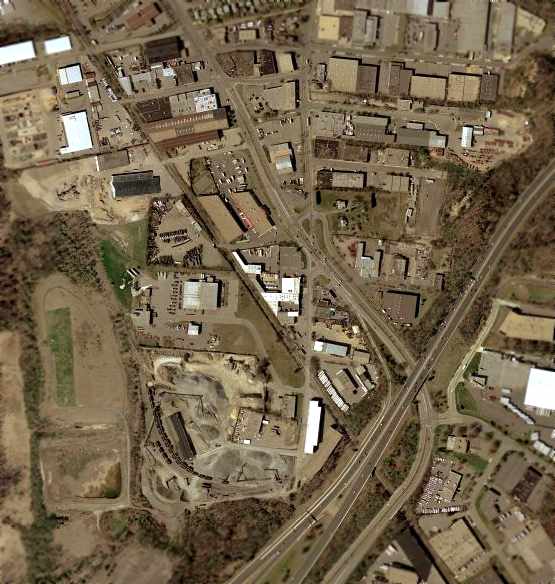
As seen in the 2002 USGS aerial photo, not a trace of the airfield remains at the site of the former Capitol Airport.
According to Keith Lippincott "I am sure the 1st location for Capitol Airport is at 52nd Avenue & Simms Lane,
which is actually in Hyattsville although it is due south of Bladensburg.
That area now is all warehouse/industrial buildings."
____________________________________________________
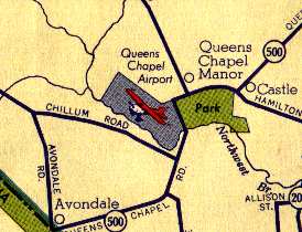
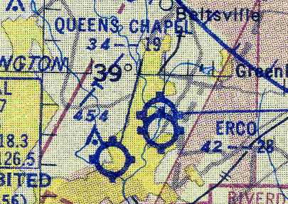
Queen's Chapel Airport, Hyattsville, MD
38.954, -76.968 (Northeast of Washington, DC)
A 1938 aerial photo of Queen's Chapel Airport showed the field to consist of an open grass area,
with what may have been a single small building on the south side of the field.
This fairly small former general aviation airport was located only three miles southwest of the College Park Airport,
and less than one mile from the Washington, DC, border.
According to the book "Maryland Aloft" by Preston, Lanman, and Breilhan,
"Queen's Chapel Airport opened in the mid 1930s,
according to a paper by Karin Thiessen.
The property was owned by the Barrett Brothers & managed by Bob Baber & Bill Henderson."
Queen's Chapel Airport was not listed
in the Airport Directory Company's 1937 Airports Directory (courtesy of Bob Rambo)
The earliest depiction which has been located of Queen's Chapel Airport was a 1938 aerial photo.
It depicted Queen's Chapel Airport as an open grass area,
with what may have been a single small building on the south side of the field.
Queen's Chapel Airport was not yet depicted at all on the 1939 Washington Sectional Chart (courtesy of Chris Kennedy).
Chuck Swim reported in 2003, "Mr. Rogers used to hang out at [Queen's Chapel] airport when he was younger.
He & his brother used to ride their bikes up to the airport & just watch the airplanes.
This was prior to 1940 & the war.
There was a bar/restaurant across the street from the airport (east) called the Greenwood Inn.
That is where the pilots hung out & ate.
I remember going there several times."
The earliest aeronautical chart depiction of Queen's Chapel Airport which has been located
was on the 1940 Washington Sectional Chart (courtesy of Mike Keefe).
It depicted Queen's Chapel as a commercial/municipal field.
According to David Talley, “My father [John Talley] mentioned to me about walking 2 miles out to Queens Chapel Airport.
He says that they would walk down to the airport prior to 1940. All they had was Cubs.”
According to the book "Maryland Aloft",
a May 1941 Civil Aeronautics Administration bulletin described Queen's Chapel Airport
"as a 21-acre property… offering fuel & minor repairs.
It possessed 2 hangars & two sod strips, 2,000' & 1,500' long."
Queen's Chapel was depicted as a commercial airport
on the 1942 Washington Sectional Chart (courtesy of Mike Keefe).
A 9/25/43 aerial view looking south at Hyde Queens Chapel Airport from the 1945 AAF Airfield Directory (courtesy of Scott Murdock)
depicted the field as having 2 grass runways.
According to the book "Maryland Aloft",
"Thiessen states that the facility closed during WW2, reopening shortly after its end."
This was presumably due to wartime security restrictions,
like many other small civil airports along the east coast during the war.
It was not depicted on the 1944 Washington Sectional Chart (courtesy of Mike Keefe).
However, Queen's Chapel Airport was listed in the 1944 US Army/Navy Directory of Airfields (courtesy of Ken Mercer),
and described as having a 1,900' unpaved runway.
Queen's Chapel Airport was depicted on the 1945 USGS topo map,
but no runways were depicted.
The 1945 Washington Sectional Chart (courtesy of John Voss),
depicted Queen's Chapel as a commercial airport.
The 1945 AAF Airfield Directory (courtesy of Scott Murdock) described Queens Chapel Airport
as a 21 acre T-shaped property within which were 4 gravel & sod runways, measuring 1,900' northwest/southeast & 1,400' northeast/southwest.
The field was said to have 2 wood & metal hangars, measuring 72' x 45' & 45' square.
The field was described as being privately owned & operated.
Queens Chapel Airport, as depicted on a 1946 USGS map.
According to the book "Maryland Aloft",
in a 1947 MD Airport Directory, "the owner was listed as Queen's Chapel Airport, Inc.,
however, Henderson remained the manager until retiring in 1949.
In that year, the operator became Maryland Flying Service
and the manager was John Dorr,
who received major assistance from his wife Debbie."
Queen's Chapel Airport, as depicted on a 1949 Shell road map (courtesy of Mike Keefe).
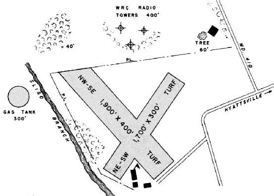
The 1950 MD Airport Directory (courtesy of Stephen Mahaley)
depicted Queen's Chapel as having two turf runways:
a 1,900' northwest/southeast strip & a 1,700' northeast/southwest strip.
Three buildings (hangars?) were south of the runway intersection.
According to Angelo, who talked to pilots who flew out of Queen's Chapel Airport,
"They say it was a real eye opener to get into & out."
Merton Meade recalled, “I remember going to to Queen's Chapel with Bob Ashburn in his Luscombe
to arrange for Johnny Door to fly an airshow at Hybla Valley in his 300 horsepower Stearman.”
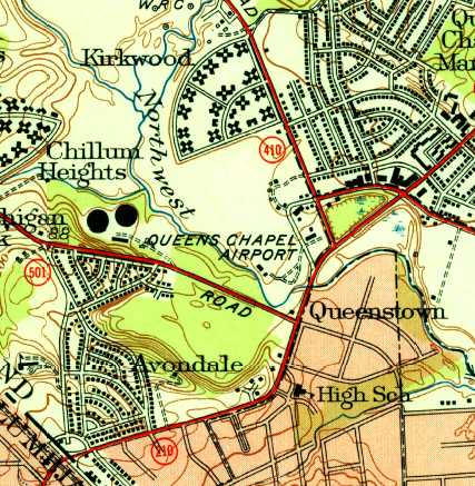
The 1951 USGS topo map depicted Queen's Chapel as an open area with a few small buildings on the south side.
Chuck Swim reported in 2003 that a friend of his "purchased his newly constructed house
in the Green Meadows development in 1952.
That is about a half mile north of the airport.
The airport was still there & operating.
He remembers that the airport operated for 1-3 years after he moved there & then closed."
Queen's Chapel was still depicted as an active airfield on the January 1954 Washington Sectional Chart (courtesy of Chris Kennedy),
and was described as having a 1,900' unpaved runway.
Queen's Chapel Airport evidently closed at some point between 1954-55,
as it was no longer depicted at all on the 1955 Washington Local Aeronautical Chart (courtesy of Mike Keefe).
In 1955, the Queen's Chapel Drive-In movie theater was opened on the southern portion of the site of the former airport.
It featured "the world's largest CinemaScope screen".
A warehouse was built just north of the drive-in,
and an apartment complex was built along the northern edge of the former airport.
The drive-in movie theater was depicted on the site of the Queen's Chapel Airport on the 1956 USGS topo map.
The airport was not depicted on the 1957 Washington Sectional Chart (courtesy of Mike Keefe),
and no trace of it appeared to remain on a 1957 aerial photo.
Ron B recalled, “As kids in the late 1950s we snuck into the Queens Chapel drive-in movie, the Mighty Mo was open then also.
The one metal hangar & a small frame building were used by the P.G. Customs car club until the hangar burned down about 1969.”
Gene Darnell reported that "the Maryland National Park & Planning Commission
ended up with what was left of the Queen's Chapel Airport when the drive-in theater was built.
The property along the creek there in Queenstown housed two corrugated tin hangar buildings
and a small one story wood frame 'office'.
A car club, The Prince George's Customs, used one hangar & the office for a few years... until the fire."
A 1965 aerial photo showed the drive-inn theater on the southern portion of the former Queen's Chapel Airport property,
with the warehouse on the northern portion.
Chuck Swim reported in 2003, "I lived adjacent to what was the airport property from 1965-73.
I returned to that area frequently until 1977.
The apartment complex was known as "Kirkwood Apartments".
The large building south of the apartments was called Kahn's Warehouse.
It was there in 1965 but was rather modern & new looking compared to the apartment buildings that seemed to be older.
Just south of the warehouse was the Queens Chapel Drive-In Movies."
"Back in 1965-68 near the southern portion of the airport property there was a drive-in restaurant called "The Mighty Mo".
I loved going there because all the hot rod cars would be there.
Next to the Mighty Mo, in a field, was a garage type building.
I always wondered why it was in an empty field of tall grass.
A bunch of the local hot rodders used the building for working on their cars out of the rain & weather.
The place was known as "The Mo Shack" by the locals.
It just appeared to be abandoned most of the time.
After seeing the chart it looks like it might have been in the area of the airport FBO buildings."
Kevin Russo recalled, “I grew up in the general area.
The Queens Chapel drive in theater was... torn down by 1977
and the adjoining land was being developed into the Forbes Industrial Park.
I used to fly radio-controlled planes on the site after the trees were cleared but before the buildings were built.”
In 1983, the WMATA took over the drive-in property via eminent domain,
and the drive-in & the Ford dealership closed to make way for a subway station on the new Metrorail Green Line.
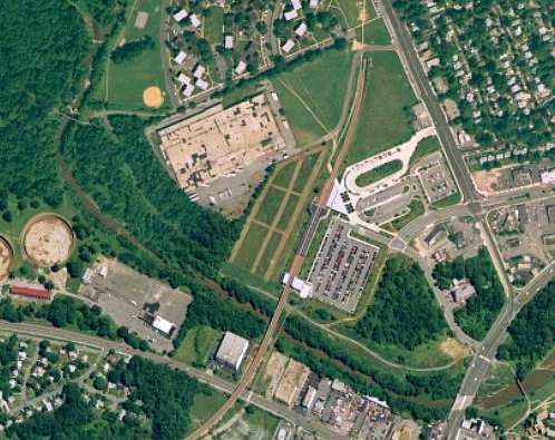
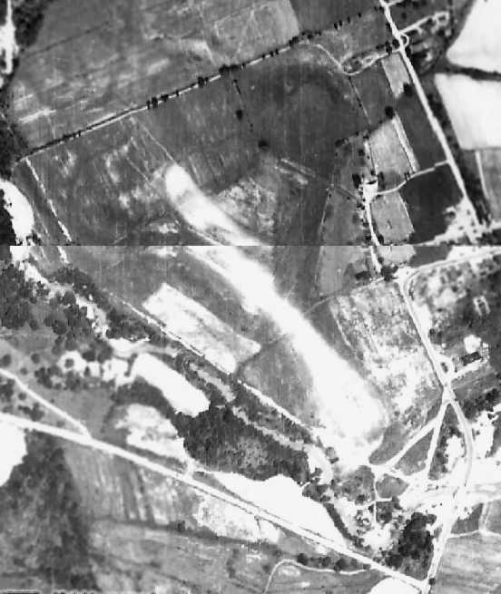
An aerial photo of the site of Queen's Chapel Airport, circa 2001.
Note the circular gas tanks in the southwest corner of the photo,
the same ones depicted in the above maps from 1945 & 1950.
Not a trace remains at the site of the former airfield.
The large warehouse building remains on the northern portion of the former airport site,
and the Metrorail subway station occupies the majority of the site.
The site of Queen's Chapel Airport is located northwest of the intersection
of Queen's Chapel Road & Ager Road.
____________________________________________________
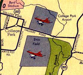
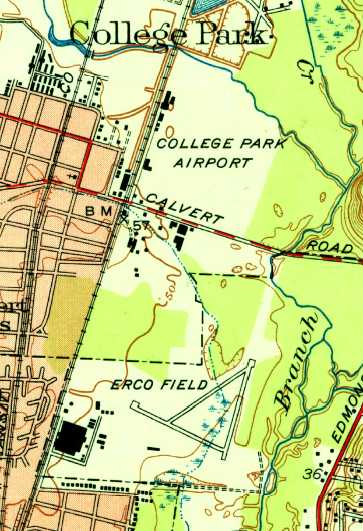
38.97 North / 76.92 West (South of College Park, MD)
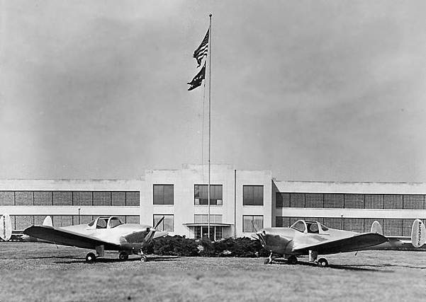
An undated promotional photo of two new Ercoupes posed in front of the ERCO factory.
Henry Berliner (who had previously developed the Berliner Helicopter at the nearby College Park Airport)
founded the Engineering & Research Corporation (ERCO) in Washington, DC in 1930.
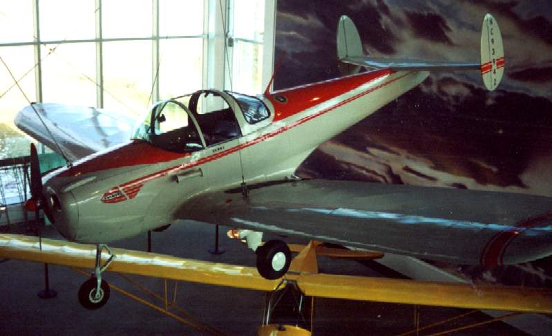
One of ERCO's most significant achievements was the development of the Ercoupe aircraft.
The Ercoupe contained many innovative design features that produced an aircraft that was safe,
easy to fly, and certified by the Civil Aeronautics Administration as "characteristically incapable of spinning."
The aircraft was designed by Fred Weick, a noted aeronautical engineer,
who worked for the National Advisory Committee for Aeronautics
before coming to ERCO in 1936.
The first experimental model of the Ercoupe was test flown at College Park Airport in 1937.
It had a single tail (unlike the eventual production Ercoupes, with their characteristic twin tails),
and was known as the "Jeep".
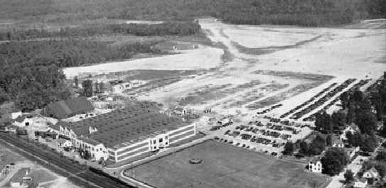
In 1937 Berliner purchased 231 acres of land in Riverdale, less than a mile south of the College Park Airport,
for the construction of an aircraft factory.
The Erco factory & airfield were evidently not yet built by 1938,
as a 1938 aerial photo showed no trace yet of the facilities, just farmland & woods.
According to a “Maryland Historical Trust Maryland Inventory of Historic Properties Form”,
“The Engineering Research Corporation Plant was constructed in 1939 in preparation for an anticipated boom in general aviation.”
Ted Turner reported, “Both my father & my grandfather worked at Erco in the late 1930s & the early 1940s.
My Grandfather was Thomas Edward Turner, Sr., my Dad was Thomas Edward Turner, Jr.”
According to Betsey Weick (daughter of Ercoupe designer Fred Weick),
"Ted Waggy was a test pilot, Lester Wells was the President,
and Henry Berliner was the Chairman of the Board.
Bob Sanders ran Sander Aviation, who eventually handled all of the sales."
Construction of the Ercoupe production prototype was completed in 1939
and certification by the CAA was completed in 1940.
The very first Ercoupe was purchased by George Brinckerhoff (the operator of the College Park Airport),
and now belongs to the National Air & Space Museum.
A total of 112 Ercoupes were produced in Riverdale before the war forced the company to suspend production.
An Ercoupe with Construction # 11, constructed on 12/4/40, was purchased on 1/4/41 by the Army and designated a YO-55.
It had civilian registration NC28655, Army Air Forces Serial # 41-18875, placed into service on 2/26/41,
and used in Army testing.
Another Ercoupe, Construction # 110, was purchased on 8/19/41 by the Army and designated an XPQ-13.
It had civilian registration NC37143, Army Air Forces Serial # 41-25196, and placed into service on 12/8/41.
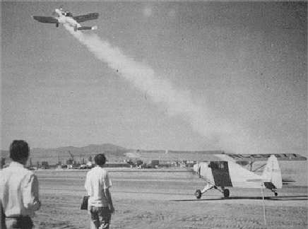
A 1941 photo of an Army XPQ-13 Ercoupe performing the world's first JATO takeoff at March Field.
According to Merton Meade, “That's Max Karant flying the JATO Ercoupe.
The caption says someone else is flying the Ercoupe, but Max told me it was him! Who knows...”
In March 1941 at March Field in California,
an Army Ercoupe piloted by Lt. Homer Bushey conducted the world's first takeoff utilizing Jet-Assisted Takeoff (JATO) rockets.
The Ercoupe used for the JATO tests was serial #11, NC28655.
It was built in December 4, 1940, and sold to the Army Air Corps for the princely sum of $10.
It was designated by the Army as an XPQ-13.
The black powder burn released 174 pounds of thrust for 12 seconds.
The first burn tests were conducted at an altitude of 6,000 feet.
That was followed by a series of tests at take-off that provided spectacular results.
JATO cut the take-off distance in half, in all weight configurations.
These tests led to widespread use of JATO during WW2.
During WW2, the ERCO factory converted from aircraft manufacturing
to producing a variety of military products, including aircraft gun turrets.
ERCO earned an "E" award for excellence in meeting manufacturing goals in its war contracts.
Employment at the Riverdale plant rose to nearly 4,000,
becoming Prince George's County's largest industrial employer at the time.
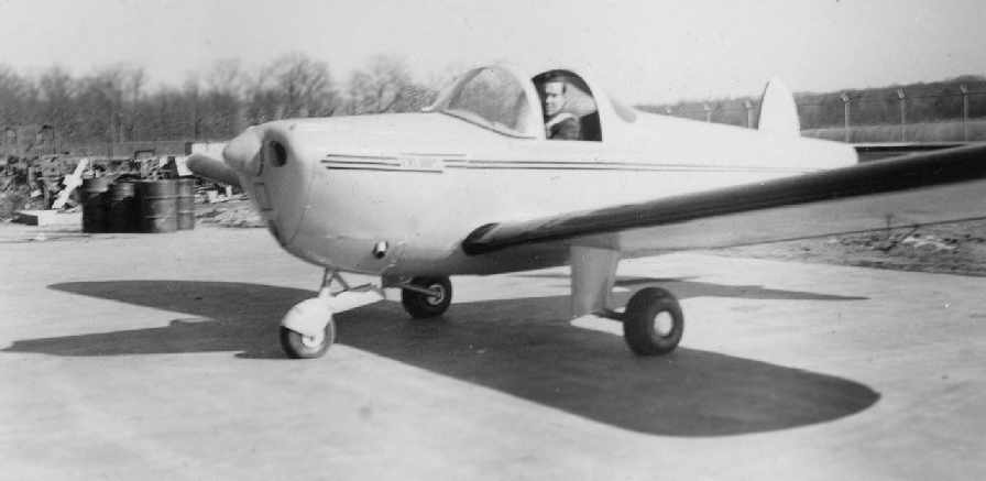
A February 1942 photo by Dottie Waggy of Ted Waggy in a Ercoupe,
presumably taken at ERCO Field (courtesy of Carol Waggy Lenza).
According to Carol, the picture “was taken about the time the war started & aluminum was unavailable.
It was called the plastic Ercoupe & was made of plywood according to Mom.
She says it flew great but proved to be too heavy for production.
She was a secretary at the ERCO plant, before I was born.”
ERCO established an airfield adjacent to its factory
at some point between 1942-43 (according to the book "Maryland Aloft").
ERCO Field was not yet depicted on the 1942 Washington Sectional Chart (courtesy of Mike Keefe).
The earliest depiction of the airfield which has been located
was on a November 1943 Sectional Chart (according to the book "Maryland Aloft").
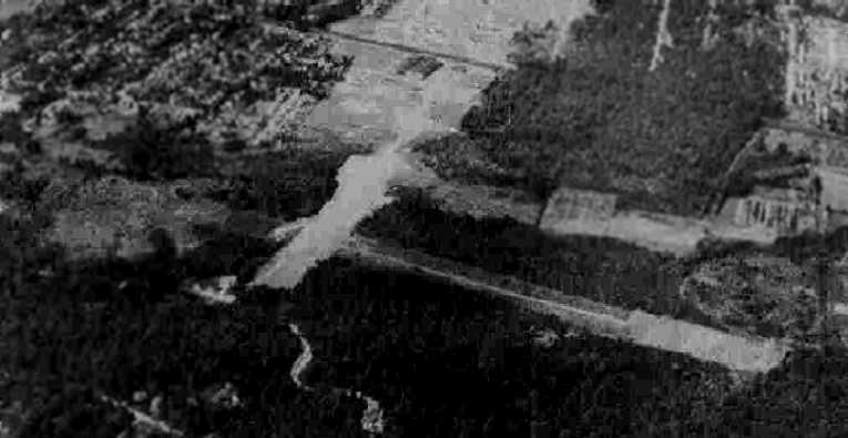
A 9/25/43 aerial view looking southwest at Erco Field from the 1945 AAF Airfield Directory (courtesy of Scott Murdock)
depicted the field as having 2 runways, with the Erco factory on the southwest side.
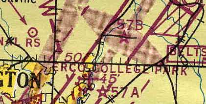
ERCO Field, as depicted on the 1944 Regional Aeronautical Chart (courtesy of Chris Kennedy).
The 1944 US Army/Navy Directory of Airfields (courtesy of Ken Mercer)
described ERCO Field as having a 3,400' unpaved runway.
Inexplicably, the 1945 USGS topo map did not depict the ERCO airfield at all,
even though it did depict the ERCO factory building.
The 1945 AAF Airfield Directory (courtesy of Scott Murdock) described Erco Field
as a 235 acre irregularly-shaped property within which were 3 sod runways, the longest being the 3,800' northeast/southwest strip.
The field was described as being privately owned & operated.
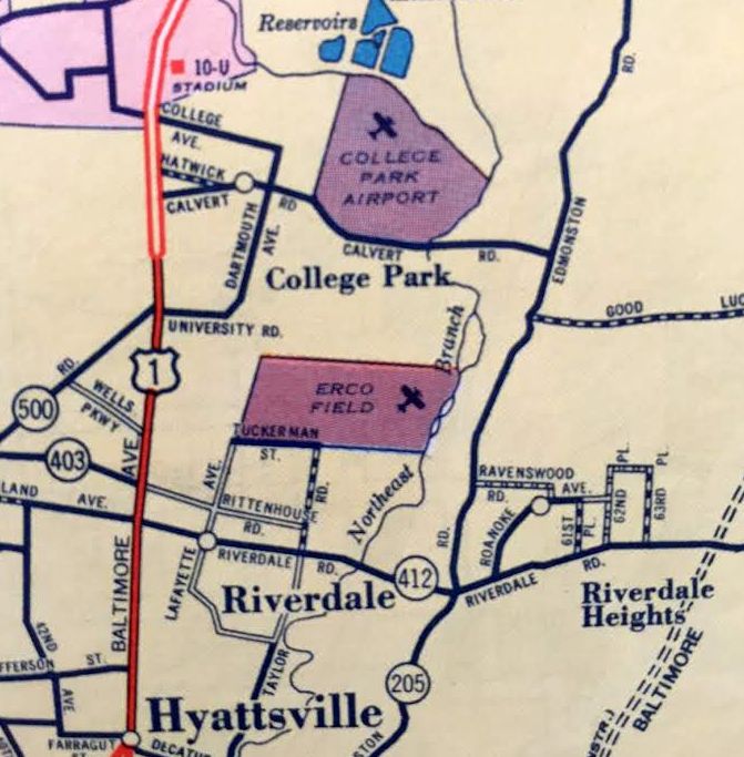
ERCO Field, as depicted on a circa 1945 road map (courtesy of Kevin Walsh).
According to the book "Maryland Aloft",
"Publications for the 1945-47 period show that it had 3 sod runways,
ranging in length from 3,600' to 2,650', in a triangular configuration.
The airfield lay just north & east of the plant area."
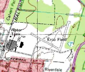
Erco Airport, as depicted on a 1946 USGS map.
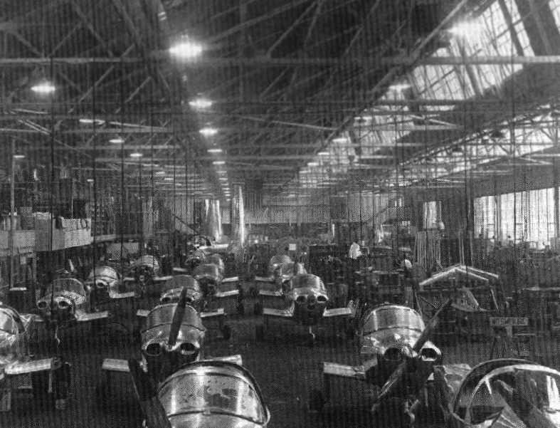
A circa 1946 photo of the interior of the ERCO plant, showing the many Ercoupes on the assembly line.
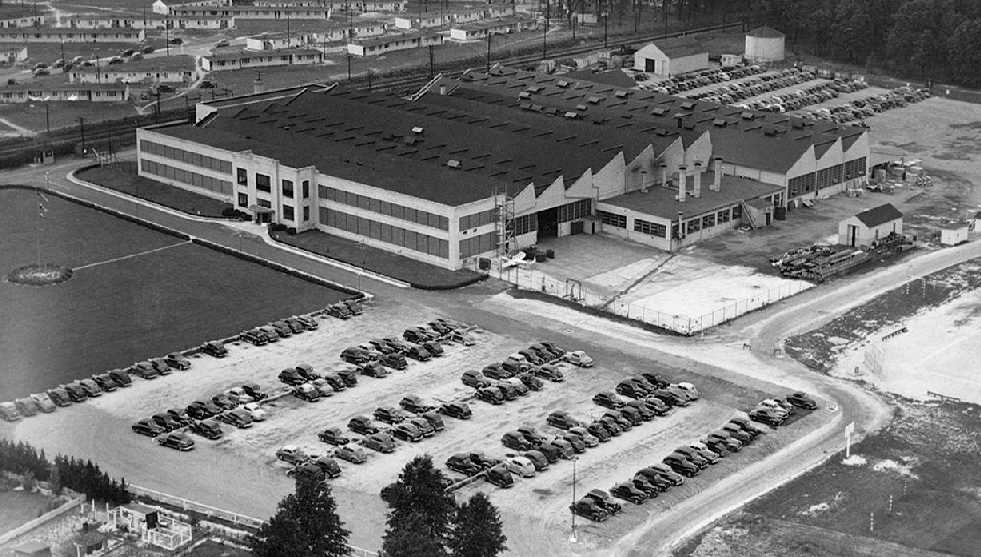
A circa 1946 aerial view looking southwest at the ERCO factory.
Note the parking lot filled with employee cars, and the rows of wartime employee housing in the background.
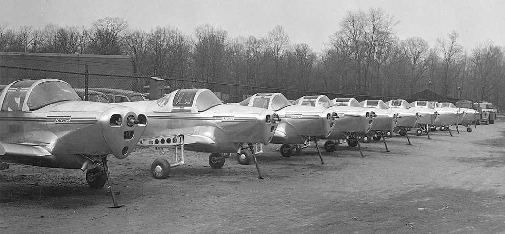
A 3/11/46 photo of a row of 9 newly-built Ercoupes at the Riverdale factory, all still lacking their wings & nose landing gear.
After World War II, ERCO reached a peak production of 34 Ercoupes per day.
A total of 4,000 planes were produced at the Riverdale factory in 1946 alone.
ERCO's marketing campaigns included the displays of its aircraft inside Macy's & other department stores.
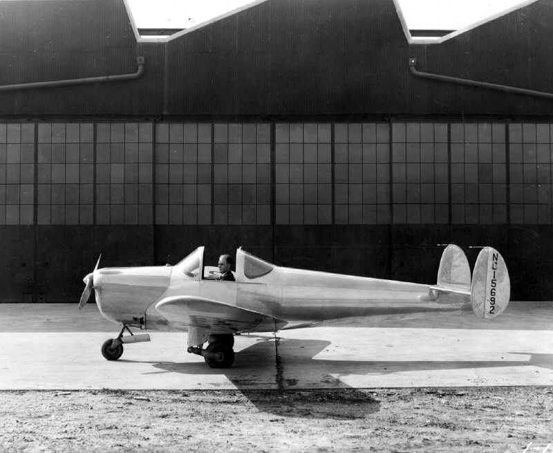
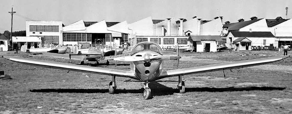
An undated photo of an unidentified pilot in an Ercoupe next to the Riverdale factory.
A 9/27/46 photo of 6 newly-built Ercoupes in front of the ERCO factory.
“Horace Thompson was the test pilot for ERCO”,
according to Keith Lippincott, who spoke to Doug Thompson (Horace Thompson's son).
According to Doug Thompson, “My dad was a test pilot for ERCO & Sanders Aviation.
Uncle Gene [Wendell Miller] also worked at ERCO & Sanders.”
According to Betsey Weick (daughter of Ercoupe designer Fred Weick),
"They built Ercoupes madly. They were building 10 a day
and then they put on a 2nd shift & they were building 20 a day
and then they put on a 3rd shift & they were building 30 a day!"
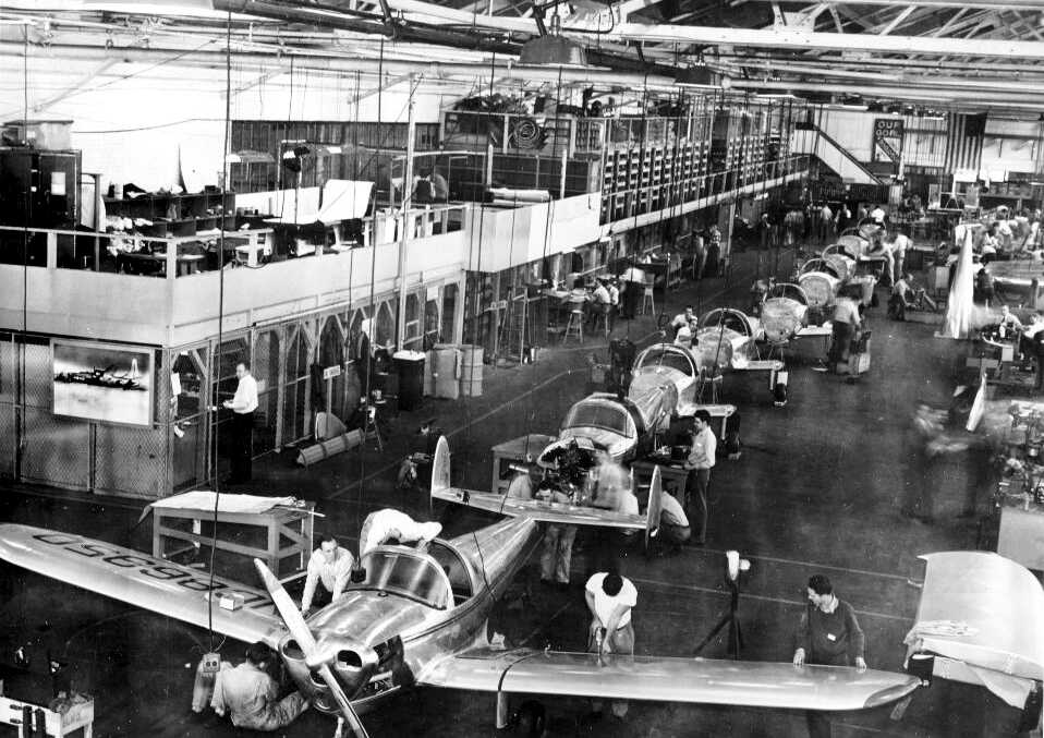
A circa 1946-47 view of the interior of the Erco factory,
showing Ercoupes coming down the assembly line.
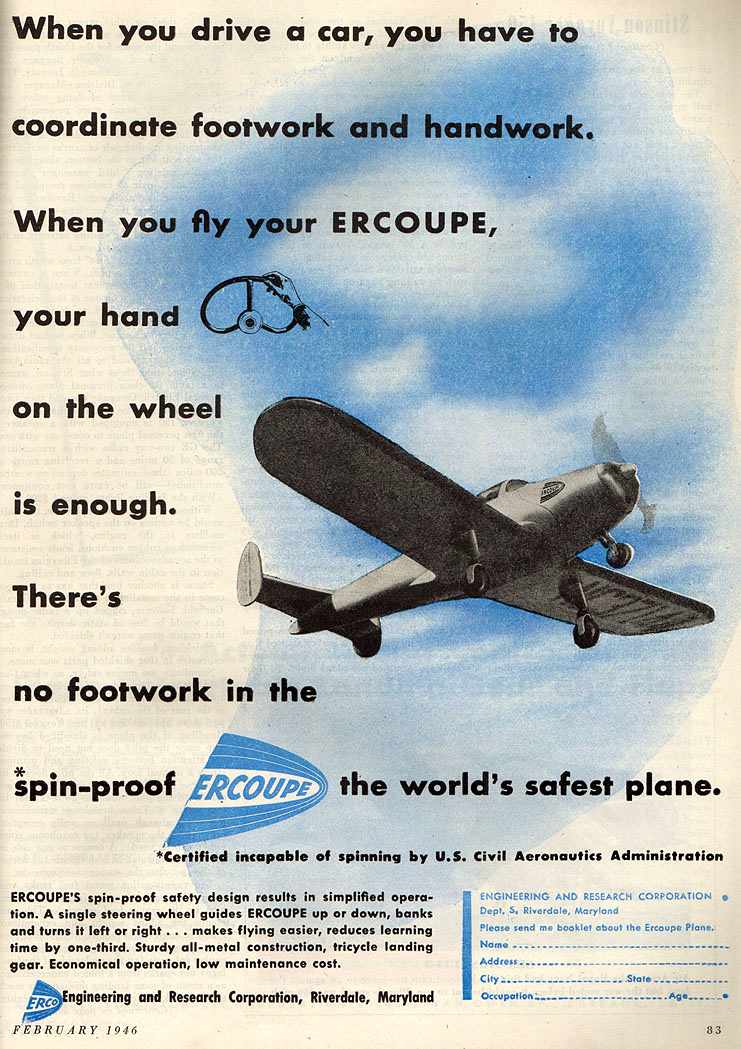
A 1946 ERCO advertisement placed in Skyways Magazine.
Unfortunately, the economic downturn of 1946 & 1947 reduced demand for light planes,
which was coupled with the fact that ERCO had quickly saturated the general aviation market.
In the words of Betsey Weick, "Suddenly the demand was filled
and they had ordered the materials for the next 6 months
and they just could not make it past that.
It came up too suddenly for them,
so Henry Berliner just went out of the airplane business."
ERCO founder Henry Berliner sold the drawings, tools, parts,
materials & distribution rights for the Ercoupe to Sanders Aviation in 1947.
Sanders continued to produce the Ercoupe at the Riverdale plant for a few more years, though.
An undated (circa 1940s?) aerial view looking northeast at the ERCO factory & airfield.
According to the book "Maryland Aloft",
"ERCO field offered fuel to transient pilots at least as early as 1947.
By 1948, it was taking on the aspect of a full-service general aviation airport
under the management of Sanders Aviation,
which had also become the marketer of the Ercoupe line.
The airport had 9 T-hangars & 2 larger ones,
as well as an office & a sandwich shop.
Although the longest landing strip was now replaced by a taxiway,
the two remaining runways were paved for 1,500' from the point of their intersection.
These runways were oriented roughly north/south & east/west,
forming a wide 'V' pointing toward the southeast.
Flight instruction & aircraft rental were offered at ERCO Field in the postwar years,
and an Ercoupe Flying Club was active during the era of Sanders management."
In 1949, ERCO began to develop & produce flight simulators
upon the encouragement of the Special Devices Center,
a branch of the Office of Naval Research.
ERCO eventually manufactured some of the first aircraft-type-specific flight simulators,
including simulators for the F9F Panther & F-86D Sabre jet fighters.
ERCO also diversified by producing school bus bodies & rocket launchers.
ERCO Field, as depicted on a 1949 Shell road map (courtesy of Mike Keefe).
Note that the airfield property was about twice the size as was depicted on an earlier 1945 map,
extending farther north toward Calvert Road.
ERCO Field was described on the 1949 Washington Sectional Chart (courtesy of Mike Keefe)
as having a 2,800' unpaved runway.
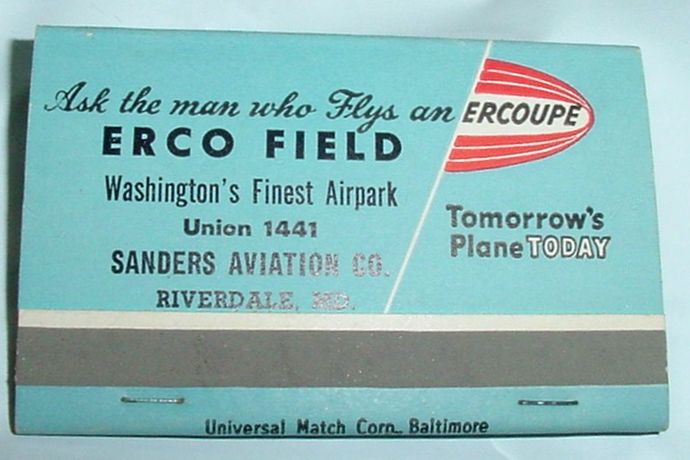
An undated (circa 1949-50s) matchbook advertising ERCO Field, “Washington's Finest Airpark”.
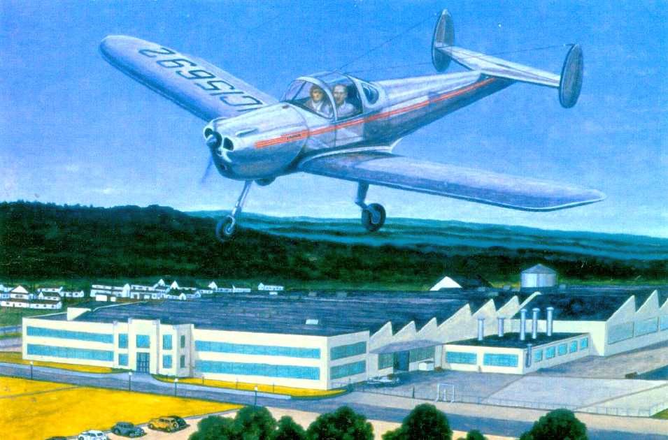
A beautiful painting of an Ercoupe overflying the Erco factory by Chas Downs.
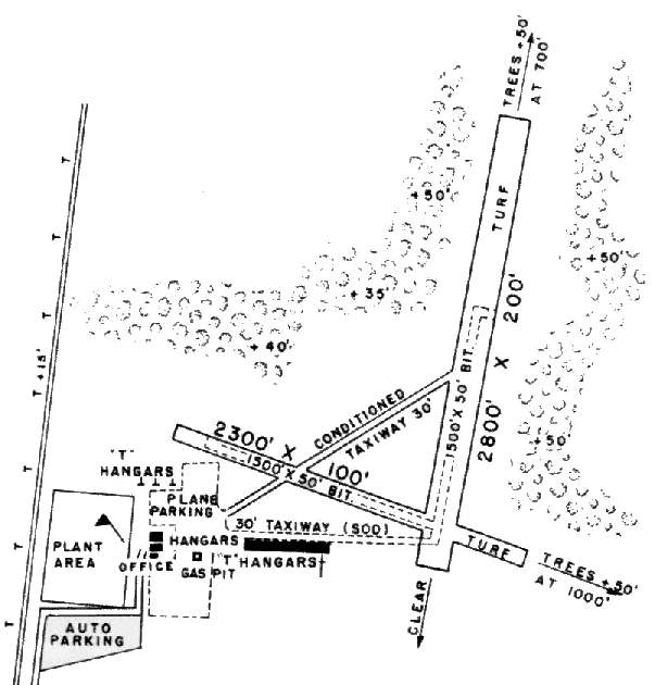
As depicted in the 1950 MD Airport Directory,
ERCO Field consisted of a 2,800 turf north-northeast/south-southwest runway
and a 2,300' northwest/southeast runway, both of which contained a 1,500' bituminous insert.
A diagonal taxiway connected the two runways.
The ERCO factory & office buildings (which still exist as of 2001)
sat at the southwest corner of the property, along the railroad.
In between the factory & the runways was a large ramp area,
with several hangars, including one row of T-hangars along the south side which was 500' long.
The 1951 USGS topo map depicted Erco Field as having 2 paved runways connected by a taxiway.
ERCO Field was described on the 1951 Washington Sectional Chart (courtesy of Mike Keefe)
as having 2 runways, with the longest being a 2,800' strip (of which 1,500' was paved).
A sad day for the disappearing Maryland aircraft industry came in 1952,
when the last Ercoupe rolled off the production line in Riverdale.
In all, ERCO & Sanders Aviation produced 5,140 Ercoupes in Maryland.
The Ercoupe design continued to live on, however,
as a succession of other smaller companies continued to produce the Ercoupe design in other states,
as late as 1970.
Ed Lyon recalled, “I worked at ERCO from 1953-61.
From 1953-57, ERCO Field was still in use by the ERCO company plane, an Ercoupe built in 1946 or 47,
and by about 20 other planes, mostly Cubs & Ercoupes.
I used to fly the company plane on business trips that required travel to places like Philadelphia, Camden, or Norristown.
I was not the company pilot; he was Ralph Queen.
I was a flight simulator design engineer, designing flight simulators for the USAF & USN,
but Ralph let me take the controls as soon as we had finished company radio calls & got on our course.”
Ed continued, “Back in the 1950s, of course, all simulators were analog.
I designed the whole simulator, except for the radar & radio aids,
which were done by engineers who had been trained in the particular radar & radio equipment to be used in the particular aircraft.
The radar subsystems & radio aids complement were then dropped into our nearly-finished simulator,
and we married these systems into the rest of the aircraft flight simulation.”
Ed continued, “I was chief design engineer (called computer engineer in those days)
for the flight simulator for the F-86D & F-86K,
and assisted others in the design of the P2V-5, F4D, A3D, AD5N, RB-66, S2F, and ZP4K.
ERCO was expert at simulation of Anti-Submarine Warfare (ASW) functions,
and usually had all these subsystems (sonobuoy dispensers, sonobuoy receivers, plotters,
radars, dipping sonars, depth-charge dispensers, etc.) all in one semitrailer,
with the flight station in another identical trailer.
The two were wired together & operated as a unit,
or the ASW part could be programmed to 'fly' a generic course, for added ASW-intensive training.”
Ed continued, “My F-86D flight simulators (ERCO built 66 of them)
were huge systems with many racks of electronics (all vacuum-tubes)
and a cockpit & instructor's station.
They went to USAF training bases, like Perrin AFB, where there were 22 of them,
and Tyndall AFB, where there were another 20.
The rest were at McGhee-Tyson AFB, McGuire AFB, McClellan AFB, and in Japan.”
Ed continued, “Since aircraft motion is described in differential equations, analog computers are a natural.
Their problem was that they were not programmable to emulate other aircraft.
The equations were hairy, and a typical servo unit might have upward of 100 potentiometers turned by the servo-motor,
each pot representing a function of that servo parameter.
The hairiest servo, in that context, was the Altitude servo, followed closely, in jet aircraft, by the Mach servo.
Amazing how many aircraft flight parameters are functions of altitude & Mach number.
The Mach 'system' was a very hairy equation, too.
To arrive at Mach number involved every other aircraft parameter imaginable.”
Ed continued, “The sound simulator was impressive.
All the possible aircraft sounds, like hydraulic motors, actuators, the engines, of course, air flow,
canopy leaks, >outdoor thunder (during simulated rough weather), were produced,
modified as functions of Mach, altitude, aircraft attitude, engine control settings, canopy closure, and all,
and sent to a huge McIntosh tube-type amplifier and twin 15-inch Jensen speakers
mounted just under the floor of the cockpit, aimed upward.
It made the pilot's butt tighten when the afterburner was lit off, for example.”
Ed continued, “I used to have to test fly most of the fighter-type aircraft,
mainly because I had learned from the huge numbers of F-86D & F-86K simulators that I tested,
exactly how to fly certain 'required' maneuvers, like the 'maximum-economy climb to 30,000 feet'.
The F-86D, of course, was a dream to fly, as was the F4D. But the A3D was a bugger.
It was longitudinally semi-stable, and it had a +/- 2 degree tolerance on pitch angle on landing.
If 2 degrees nose high, the tail skid dragged;
2 degrees too nose-low, and the nose gear landed first.”
Ed continued, “I used to marvel at Henry Berliner’s flying ability.
He had only one arm, and had to do everything with one hand,
and that included calming down his huge German Shepherd dog, Baron, during takeoff,
when the dog would invariably begin jumping up & down on the right seat, trying to lick Henry’s face.
He would be fending off the dog & taking off at the same time, all with one arm.
When he used the east/west runway, we could stand at the plant & see right down the runway
and watch his plane zig-zagging its way into the air.
Once airborne, the dog apparently calmed down, because his flying was smooth & straight.”
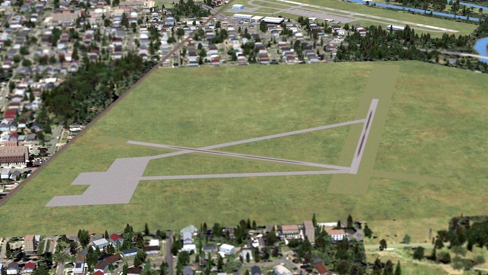
A PC flight simulation scenery depiction looking north at ERCO Field - very appropriate given that the Erco factory was used to manufacture military flight simulators.
Note Erco's proximity to College Park Airport in the background.
ERCO Field was still depicted as an active airfield on the January 1954 Washington Sectional Chart (courtesy of Chris Kennedy),
and was described as having a 2,800' unpaved runway.
In 1954, ERCO & its property were purchased by American Car & Foundry Corporation (later known as ACF Industries, Inc.).
ACF was a diversified manufacturing company
whose products ranged from railroad equipment to nuclear power equipment.
The ERCO operation was renamed as the ERCO Division, ACF Industries Inc.,
and eventually became designated as the Flight Simulation Division of ACF.
ERCO Field was described on the 1955 Washington Local Aeronautical Chart (courtesy of Mike Keefe)
as having 2 runways, with the longest being a 2,800' strip (of which 1,500' was paved).
Ed Lyon recalled, “The field would be closed occasionally in earlier years [before 1957]
when ERCO had to take their ball turrets (for the B-47 & Martin Mariner aircraft) down to the east end of the field
and build a gun range butt to shoot the guns into, during military acceptance tests.
Apparently blanks did not provide the same recoil kick that live ammo did, and did not stress the turret like the real thing,
so they shot real ammo down at that end of the field.
During the week or two of such tests, the field would be closed.”
John Turner recalled, “I remember picking up my Dad after work at the ERCO Riverdale facility back in the late 1950s.
I used to pester my mother to get there early so we could watch the planes take off & land.”
A 1957 aerial view depicted the Erco factory & 2 paved runways, with a connecting taxiway.
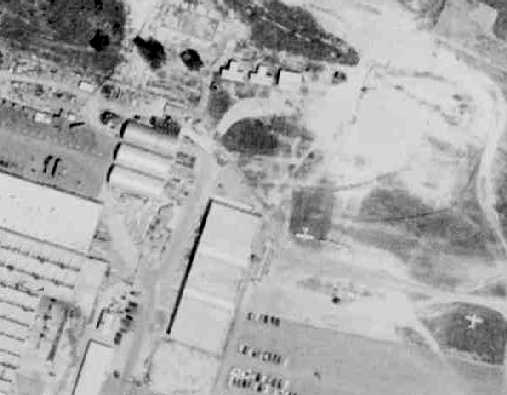
The last photo which has been located showing planes at Erco Field was a 1957 aerial view.
It depicted 2 or 3 single-engine aircraft parked on the east side of the factory.
Ed Lyon recalled, “In 1957 I was transferred to a new department at ERCO, designing Over-the-Horizon radar;
we prototyped one such radar at ERCO, erecting the huge antennas at the west end of the airfield.
That closed the field for aircraft use.”
Ed continued, “After I got transferred to the OTH radar research department,
ERCO went on with the flight simulator for the KC-135, the P5M, and the F-105, as well as several submarine simulators.
They also turned out a great number of Navy generic 'Twin-engine trainers'.
These were twin-radial-engined aircraft that had the usual systems,
like navigation electronics, automatic landing, multiple fuel tankage, etc,
to give single-engine pilots some twin experience before they went into a particularized aircraft.”
ERCO Field was no longer depicted at all on the 1957 Washington Sectional Chart (courtesy of Mike Keefe).
In 1957, ERCO Division merged with another division of ACF,
the Nuclear Energy Products Division, and became known as Nuclear Products, ERCO Division.
The Riverdale plant served as the Nuclear Products Division Headquarters.
ERCO Field was labeled "Abandoned airport"
on the 1960 Washington Local Aeronautical Chart (courtesy of Mike Keefe).
According to Ed Lyon, in “1961... our research department [ERCO's radar group] was moved to Bladensburg, MD.”
Ed Lyon continued, “Link eventually bought the ERCO flight simulation group, in about 1963,
and that is when the ERCO plant was finally abandoned.
That's when the ERCO people had just built their first digital flight simulator
and had a very good group of people doing visuals & cockpit motion.”
A 1965 aerial photo showed the Erco factory & 2 paved runways,
with the northern end of the north/south runway having been bisected by a road.
There were no aircraft visible on the field.
Other sources indicate that in 1965, the General Precision Equipment company purchased the operations
of the Riverdale plant of the Electronics Division of ACF Industries, Inc.
The company moved in 1967 from Riverdale to a new building in Montgomery Industrial Park in Silver Spring.
This operation later became part of the Link Company (founded by the inventor of the flight simulator, Ed Link).
The paved runways of the abandoned ERCO Field were still very prominent
in this 1967 aerial photo by Chris Kennedy, looking south.
A circa 1967 photo by Roy Williamson of one of Erco's more unique products,
a flight simulator for the Air Force's RB-66 Destroyer.
Roy recalled, “I was at Shaw AFB, SC from 1964-69.
When I got there they had one RB-66 Simulator & shortly afterwards we received one from France when De Gaul kicked the U.S. out.”
ERCO Field remained abandoned for years as overgrown field,
and was occasionally used by local residents to operated remote-controlled model aircraft.
Mike Mewshaw recalled, “I grew up in the 1970s going to Erco when we were kids.
I remember walking the airfield & seeing just mounts of trash & junk.
I remember walking through the woods & seeing tail sections & cockpit sections just sitting there.
My grandparents(Harvey & Marggie Holcombe) lived on Taylor Road
and even though it was a junk yard we always found something out there unusual.”
The 1979 USGS topo map continued to depict the 2 paved runways of Erco Field,
even though it had been closed for 22 years by that point.
According to the book "Maryland Aloft",
by 1985, ACF Industries was still the owner of the former ERCO facility,
but several federal agencies were using the former factory building
(including being used as a distribution center for aeronautical charts).
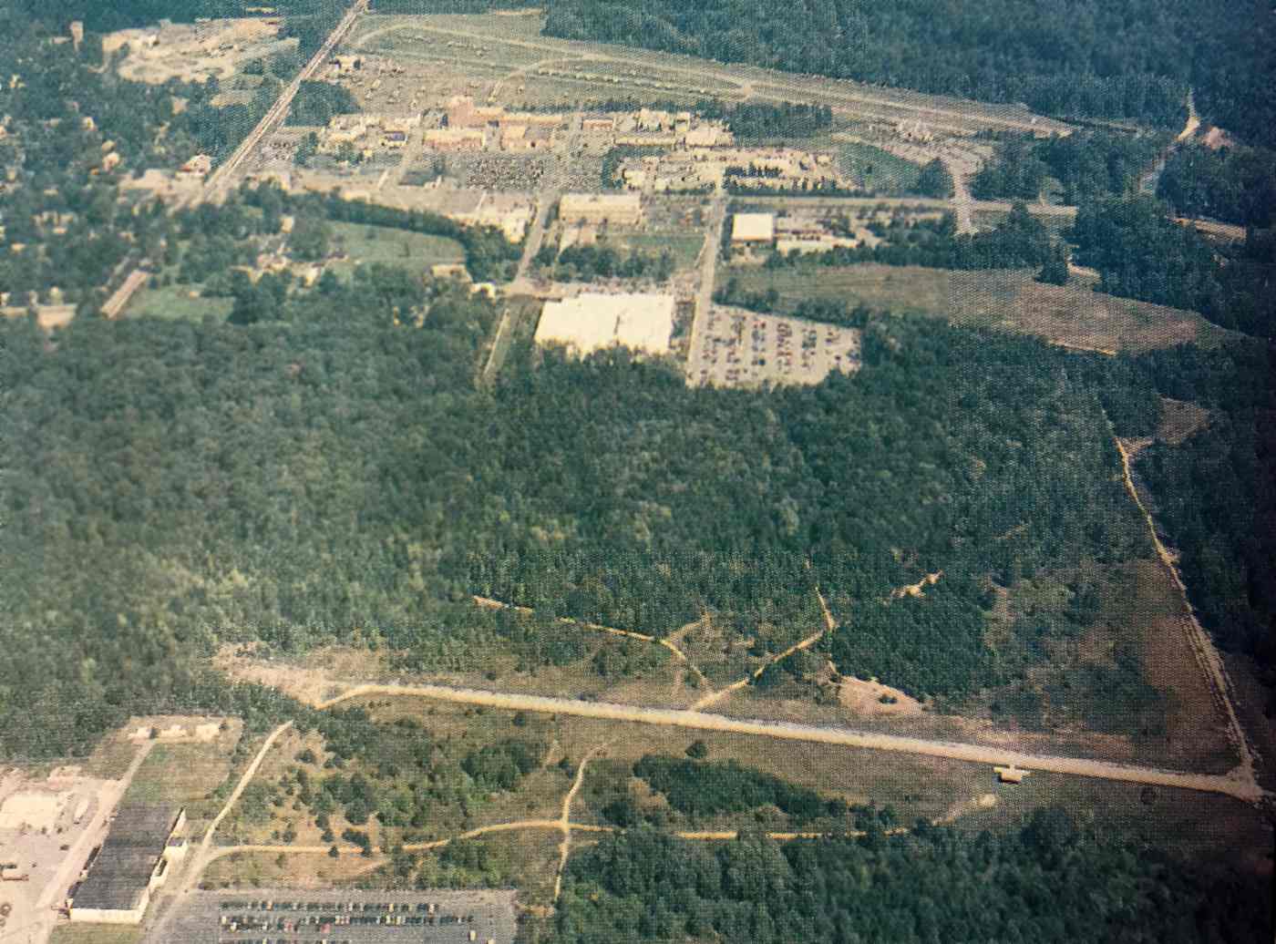
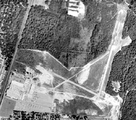
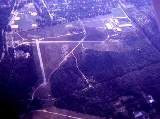
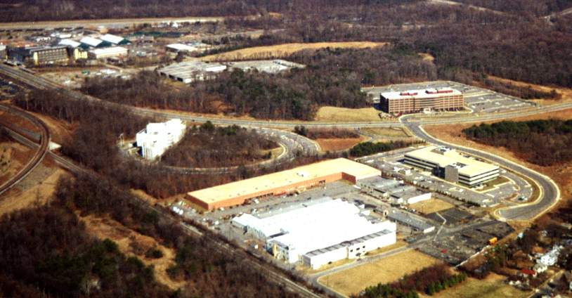
An undated aerial view looking north at ERCO Field (foreground) & College Park Airport (background) from a 1987 article (courtesy of Jim Higgins).
The pavement of the 2 former ERCO runways remained, although significantly deteriorated,
along with at least 4 individual T-hangars along the southwest & southeast sides of the east/west runway.
By the time of this 1989 USGS aerial view, the paved runways at ERCO Field had deteriorated,
with trees starting to encroach around them.
A 2001 photo by Paul Freeman of an Ercoupe suspended from the ceiling of the College Park Aviation Museum.
Although the museum's Ercoupe display mentions that it was initially flight tested at the College Park Airport,
it makes no mention of the former ERCO Field, or even of the ERCO factory which remains standing less than a mile away.
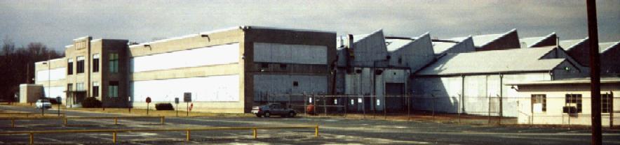
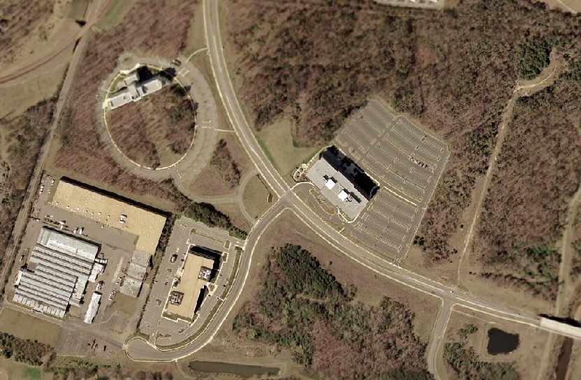
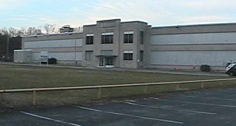
A 3/01 photo by Paul Freeman looking northwest at the former ERCO factory.
A 2/01 aerial photo by Paul Freeman looking northeast at the former ERCO factory (the white building in the center foreground).
The area behind the factory was previously the location of the runways of ERCO Field,
but had been redeveloped at some point between 1989-2001 with several large office & industrial buildings.
A new road (River Road) had been built over the former northwest/southeast runway.
However, the majority of the former north/south runway remained intact (north of River Road),
although significantly deteriorated.
The runway of the College Park airport is visible at the top left of the picture.
According to the book "Maryland Aloft",
as of 2002 the factory building was owned by the University of Maryland.
In 2002, the Maryland Historical Trust recommended that the main building was eligible
to be listed in the National Register of Historic Places.
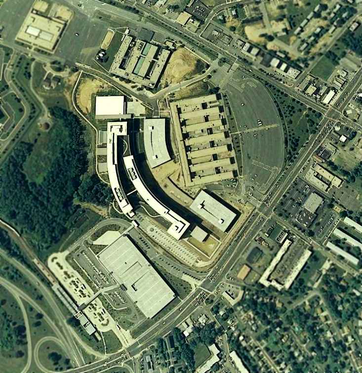
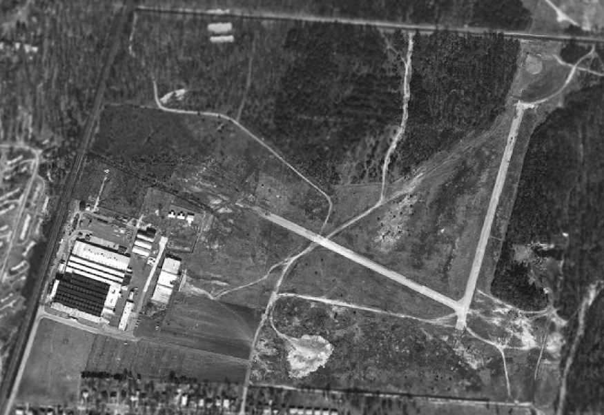
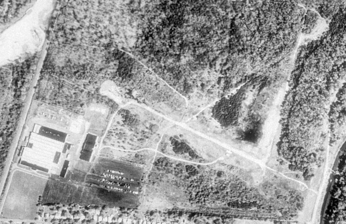
A 2002 USGS aerial view of the site of the former ERCO Field,
with the factory remaining standing at the southwest corner.
Note the remnants of the former north/south runway pavement, on the east side of the image.
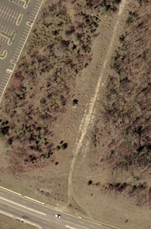
A 2002 USGS aerial view of the remnants of the former north/south runway pavement, just north of River Road.
Paul Freeman drove by the former ERCO factory building in 2003,
and was pleased to see it still standing, though apparently abandoned.
It still bore a sign indicating its use as an aeronautical chart distribution center for the federal government.
A 2004 photo by Fernando Rodriguez looking north at the site of ERCO's north/south runway.
"The property was purchased by University of MD College Park & is currently under development."
A 2004 photo by Fernando Rodriguez of the former ERCO factory building.
"It does appear to be abandoned. However, the outside lights were on & there was a civilian truck parked inside the fence."

A 2005 aerial view looking north at the former ERCO factory building.
Keith Lippincott reported in 2006, “The original ERCO factory is being sold by the University.
It will probably be developed into additional housing.”
Mike Arnold reported, “In 2006 the University of MD was negotiating with the State Historic Preservation Office (MHT)
to document & demolish the factory structure for housing.
Fortunately, the rampant development market collapsed & the University did not ultimately get approval from MHT to document & demolish the factory.”
However, Sherri Johns reported, “The University planned to sell the property in 2006, but the sale fell through due to the economic downturn.”
A 2006 photo by Louie Armstrong of the Erco factory entrance.
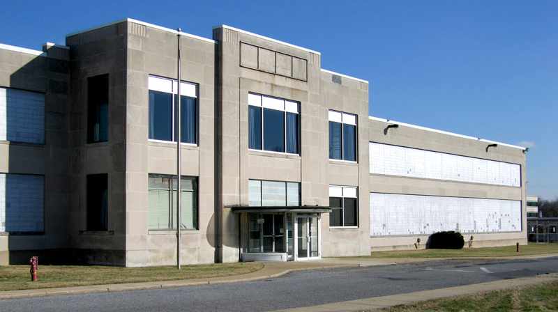
A 2006 photo by Louie Armstrong looking northeast at the front of the Erco factory.
A 2006 photo by Louie Armstrong of the side of the Erco factory.
Mike Arnold reported in 2010, “Just this year Prince George's County has added it to their County Inventory of Historic Sites,
so any change will at least have to follow a more lengthy public process.
We hope to get it added to the National Register of Historic Places either through the County preservation office or independently if necessary.
We are in the process of forming a local 'Friends of ERCO' preservation group which intends to educate and generate more local, regional & national interest
in its preservation & adaptive reuse by the University or someone willing to buy the place from them.
We have also had ERCO on our local 'Most Endangered Historic Sites in Prince George's County' list (an instrument of the local county preservation NGO's)
for several years as the University has been managing its neglect, and vague about its future (now for more obvious reasons).”
Sherri Johns reported in 2011, “There are no immediate plans for the property, but because of the deteriorating condition,
they hired me to carry out a study of the property & make recommendations for reuse & salvage.
The roof in the assembly section is partially collapsed & the lovely Art Deco Office/ reception area has been damaged by water & vandalism.
Honestly, I don't think the prospects for the building are very good.”
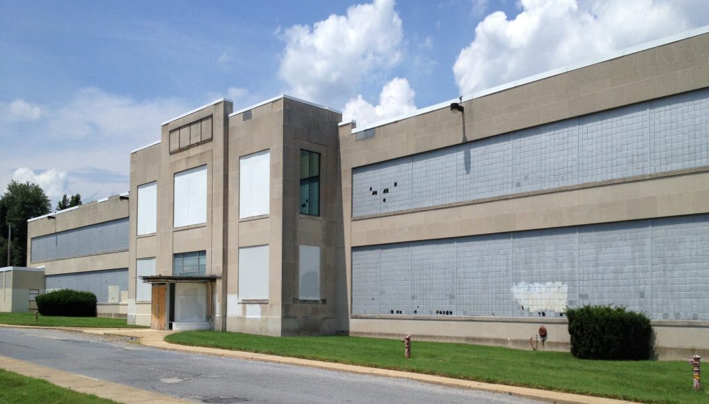
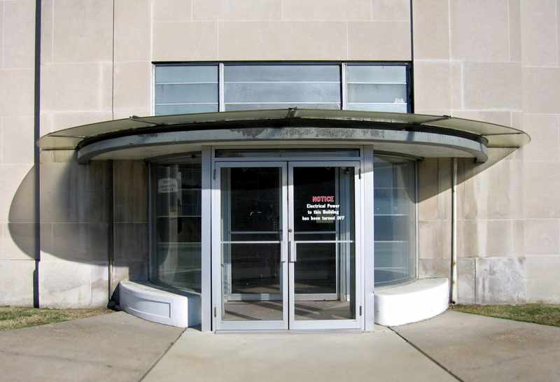
A 7/21/13 photo by Paul Freeman looking northwest at the front of the Erco factory.
Thanks to Ron Plante for serving as copilot/navigator.
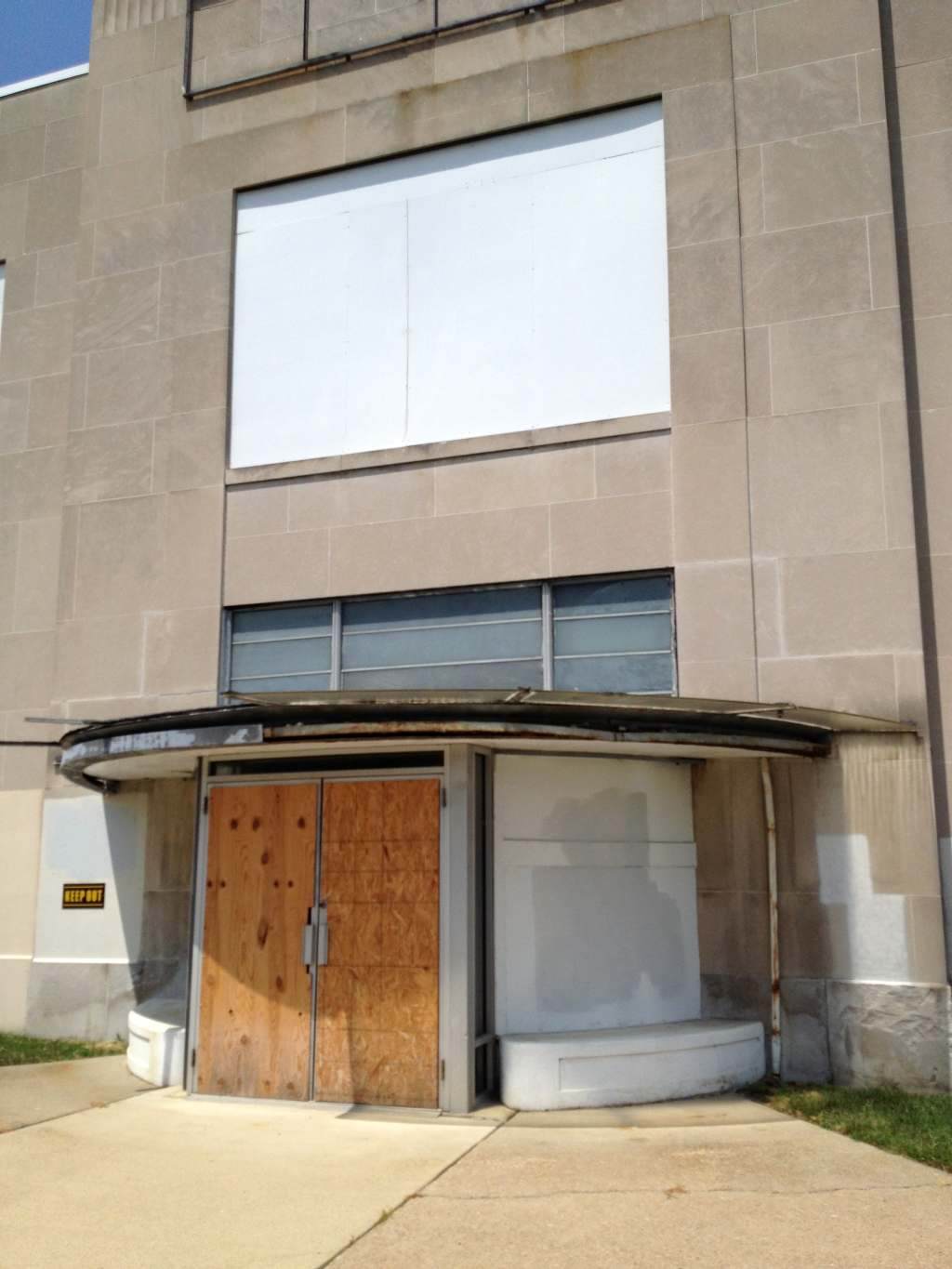
A 7/21/13 photo by Paul Freeman looking northwest at the Erco factory entrance,
which has evidently been boarded up at some point between 2006-2013.
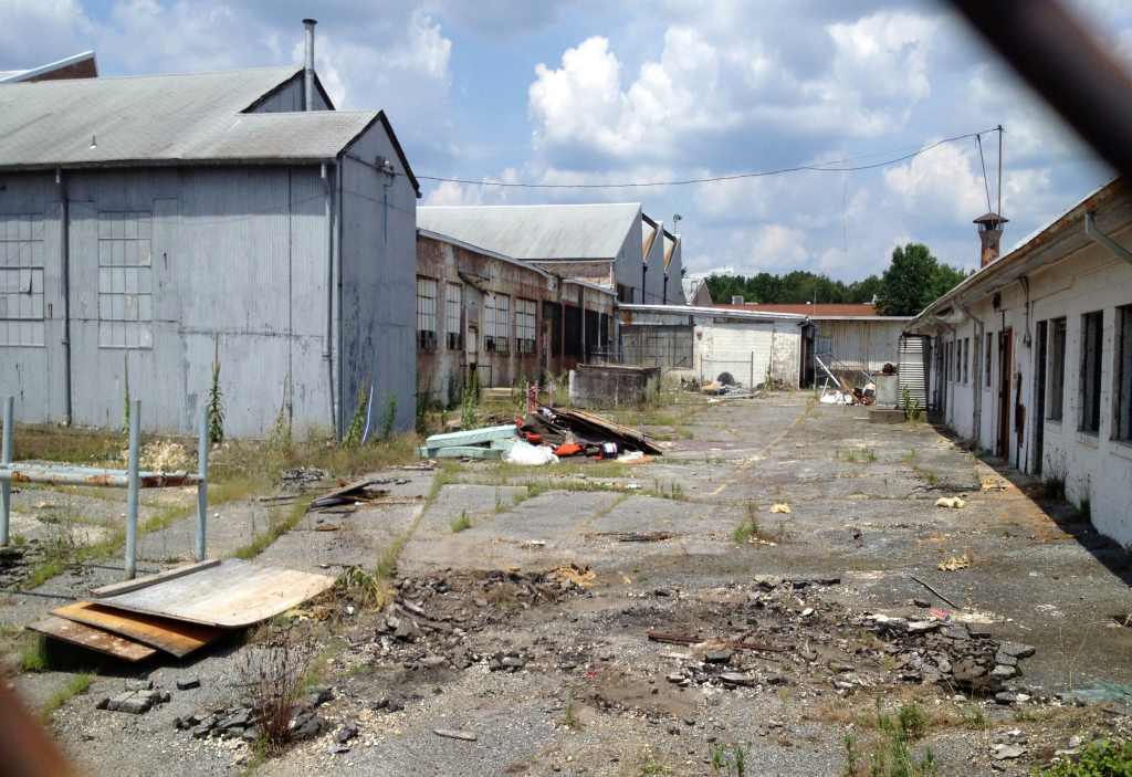
A 7/21/13 photo by Paul Freeman looking north at the area to the east of the Erco factory.
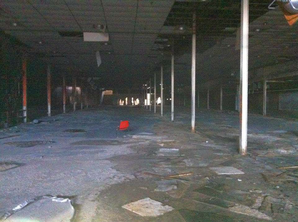
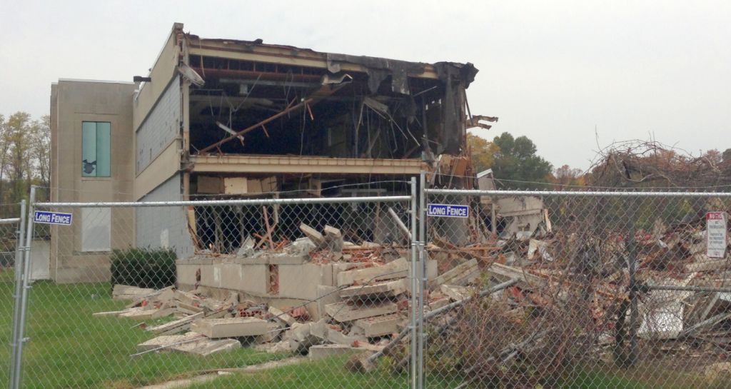
An undated photo of the interior of the Erco plant, taken sometime before its 10/31/13 demolition.
A lot of MD aviation manufacturing history took place inside that gloomy space.
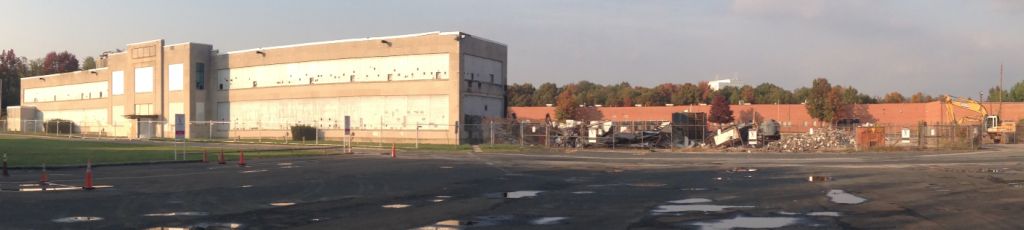
A 10/30/13 photo by Jehovan Montelara of a sad sight: all of the Erco factory had been demolished,
with only the office portion along the front remaining (as of that day).
The very next day, a 10/31/13 photo by Jehovan Montelara showed the remaining portion of the Erco complex being demolished.
Jehovan observed, “Even more carnage ensued today.”
What a shame that such an extensive remnant of Maryland's aircraft manufacturing industry couldn't have been repurposed.
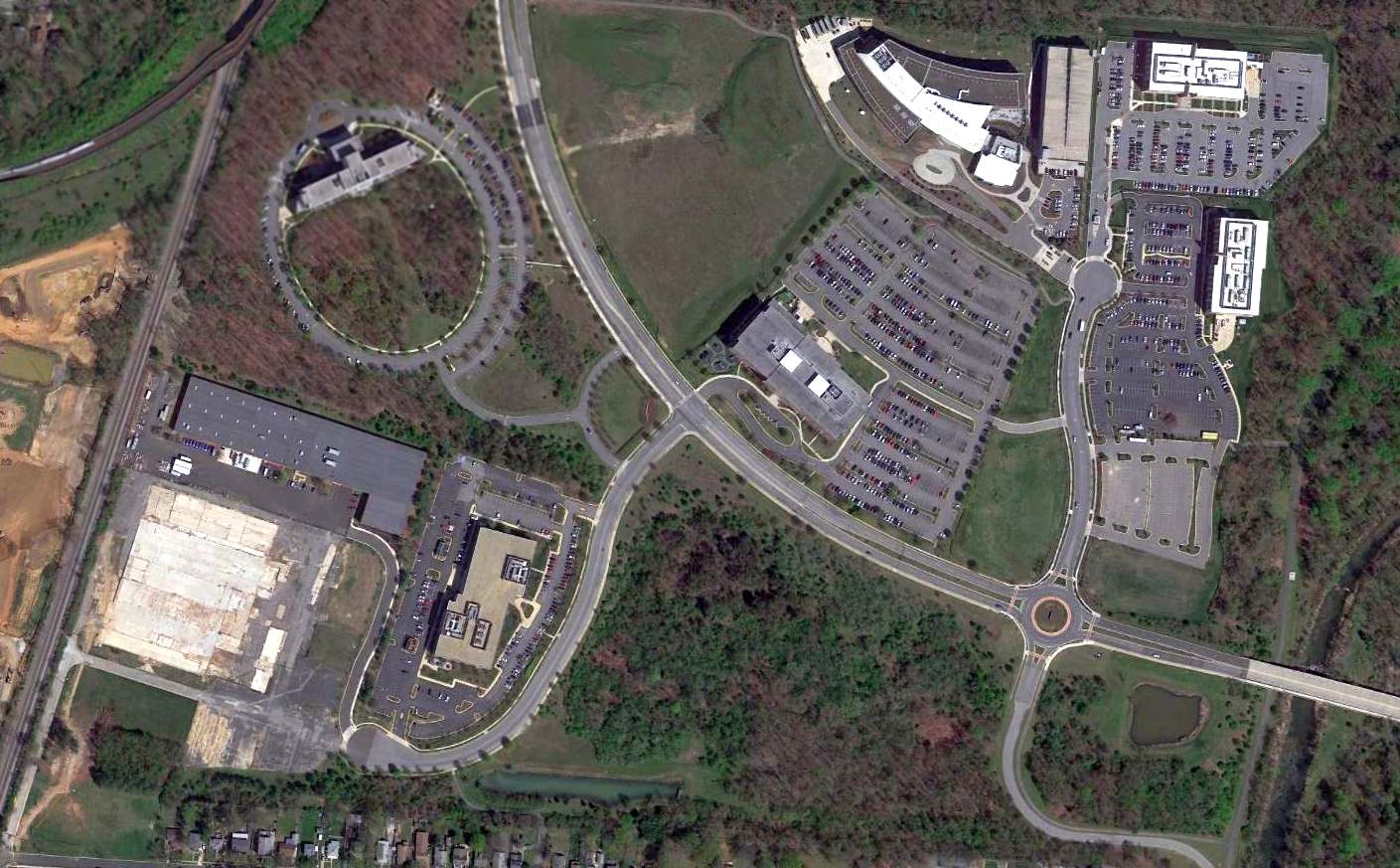
A 2016 aerial view showed a sad sight for anyone who appreciates Maryland aviation history:
the ERCO factory at the southwest has been leveled, and all traces of the ERCO airfield have been removed.
The site of the ERCO factory is located at 6501 Lafayette Avenue in Riverdale,
north of Tuckerman Road & east of the Baltimore & Ohio Railroad line.
____________________________________________________
Since this site was first put on the web in 1999, its popularity has grown tremendously.
That has caused it to often exceed bandwidth limitations
set by the company which I pay to host it on the web.
If the total quantity of material on this site is to continue to grow,
it will require ever-increasing funding to pay its expenses.
Therefore, I request financial contributions from site visitors,
to help defray the increasing costs of the site
and ensure that it continues to be available & to grow.
What would you pay for a good aviation magazine, or a good aviation book?
Please consider a donation of an equivalent amount, at the least.
This site is not supported by commercial advertising –
it is purely supported by donations.
If you enjoy the site, and would like to make a financial contribution,
you
may use a credit card via
![]() ,
using one of 2 methods:
,
using one of 2 methods:
To make a one-time donation of an amount of your choice:
Or you can sign up for a $10 monthly subscription to help support the site on an ongoing basis:
Or if you prefer to contact me directly concerning a contribution (for a mailing address to send a check),
please contact me at: paulandterryfreeman@gmail.com
If you enjoy this web site, please support it with a financial contribution.
please contact me at: paulandterryfreeman@gmail.com
If you enjoy this web site, please support it with a financial contribution.
____________________________________________________
This site covers airfields in all 50 states.
For the site's main menu: Home