Abandoned & Little-Known Airfields:
Central Kansas
© 2002, © 2016 by Paul Freeman. Revised 5/8/16.
This site covers airfields in all 50 states: Click here for the site's main menu.
____________________________________________________
Please consider a financial contribution to support the continued growth & operation of this site.
Cassoday Intermediate Field (added 7/1/12) - Dodge City AAF / Ford County Airport (revised 5/8/16)
Great Bend Airport (1st location & 3rd location) (added 6/8/13) - Great Bend Airport (2nd location) (added 6/8/13)
Hutchinson NAS / Yoder Commercial Airport / Sunflower Gliderport (revised 1/16/15) - Sterling Airport (added 7/26/15) - Walker AAF / Victoria-Pratt Airfield (revised 8/24/14)
____________________________________________________
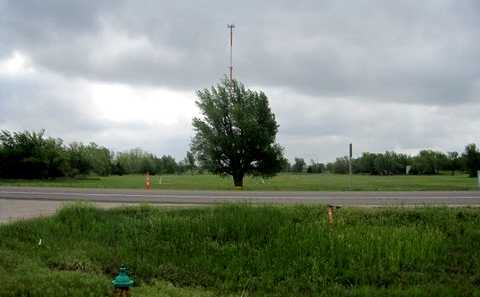
Sterling Airport, Sterling, KS
38.32, -98.22 (Northwest of Wichita, KS)
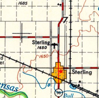
Sterling Airport, as depicted on the 1955 USGS topo map.
Photo of airport while in use has not been located.
This small general aviation airport was evidently established at some point between 1945-55,
as it was not yet listed among active airports in the 1945 AAF Directory (courtesy of Scott Murdoch).
The earliest depiction which has been located of Sterling Airport was on the 1955 USGS topo map.
The most detailed depiction which has been located of Sterling Airport was on the 1967 USGS topo map.
It depicted Sterling Airport as having a single unpaved north/south runway with 1 small building on the southeast side.
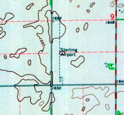
The last depiction which has been located showing Sterling Airport in operation was on the 1985 USGS topo map.
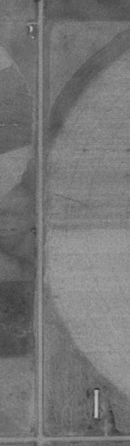
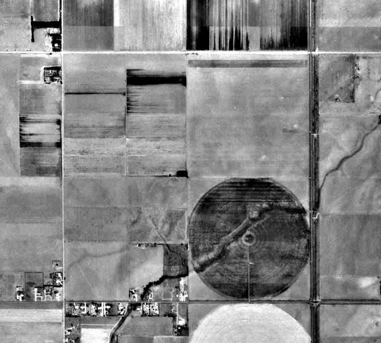
Sterling Airport was evidently closed at some point between 1985-91,
as a 1991 aerial photo showed the runway had been covered by a circular-irrigation farm field.
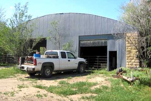
The hangar remained intact on the southeast side, though.
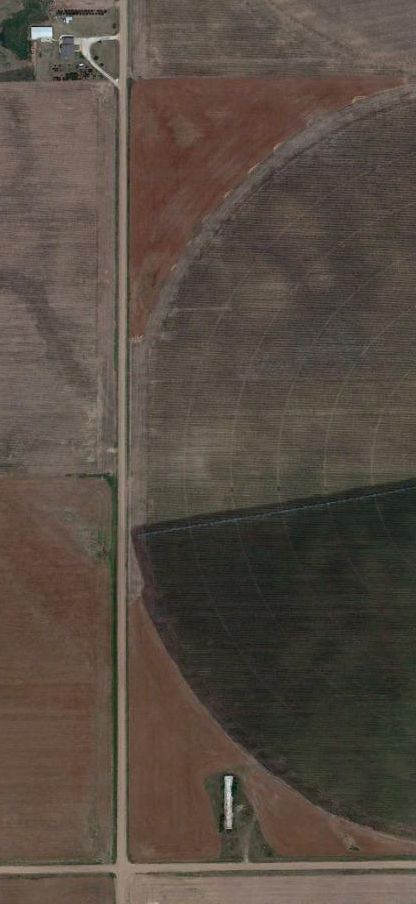
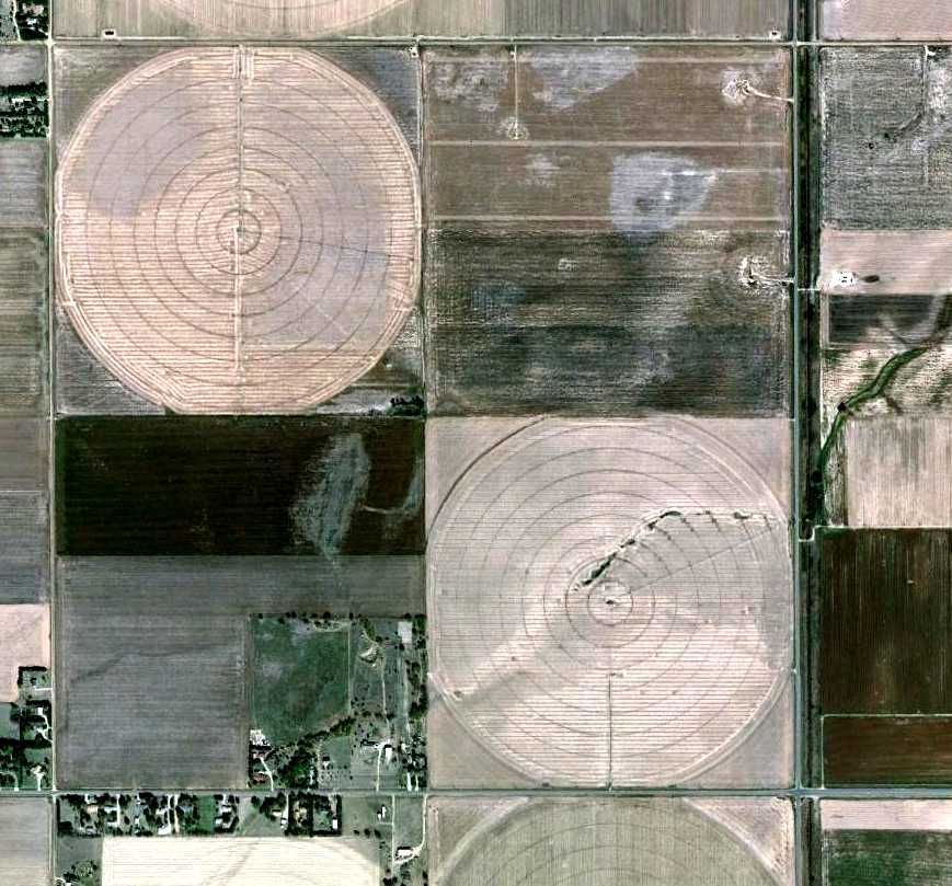
A 2011 aerial view showed no change at the site of Sterling Airport,
with the runway area covered by a circular-irrigation farm field, but the hangar remaining on the southeast side.
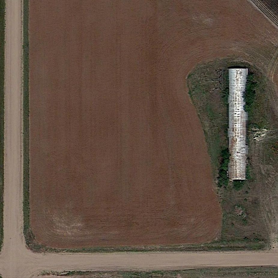
A closeup from the 2011 aerial view shows the letters “Sterling” are still visible on the former Sterling Airport hangar.
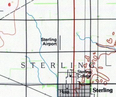
The site of Sterling Airport is located northeast of the intersection of Avenue U & 15th Road.
____________________________________________________
Great Bend Airport (1st location & 3rd location), Great Bend, KS
38.39 North / 98.76 West (Northwest of Wichita, KS)
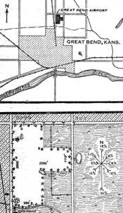
The original Great Bend Airport, as depicted on the 1930 Commerce Department Airway Bulletin (courtesy of Phillip Schulz).
Photo of airport while in use has not been located.
The municipal airport for the City of Great Bend has gone through a series of no less than 4 different locations since 1928.
Phillip Schulz reported that the first location of Great Bend Airpoprt “was dedicated in the fall of 1928.”
The earliest depiction which has been located of the original Great Bend Airport
was on the 1930 Commerce Department Airway Bulletin (courtesy of Phillip Schulz).
It depicted a 74 acre T-shaped field located one mile north of the city limits.
It described Great Bend Airport as having 2 sod runways, oriented 2,600' north/south & 2,050' east/west.
A single 55' x 50' frame hangar was said to have “Great Bend” painted on it.
The field was described as being owned by the city, and operated by the Chamber of Commerce.
According to Phillip Schulz, the original location “must have closed around 1941”,
and was replaced by the 2nd location of Great Bend Airport, 5 miles west of town.
However, this location of the Great Bend Airport returned to use very soon.
According to Phillip Schulz, “The Army Air Forces required Great Bend close the #2 airport due to the proximity to the AAF [which had been established in 1942-43].
The city then leased ground north of Great Bend on the same land where the Airport #1 was located.
[Great Bend Airport] Number 3 was in the shape of a T.
It was called Great Bend's New Airpark.”
The hangar at Airport #3 was “built at the end of 1943 - early in 1944.
[Airport] Number 3 was in full operation in 1944.”
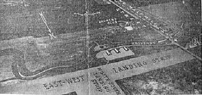
A circa 1944 illustration looking southwest at the 3rd location of Great Bend Municipal Airport,
as published by the KS League of Municipalities (courtesy of Phillip Schulz).
It depicted 2 runways in a T-shape, with 3 buildings along the southwest side.
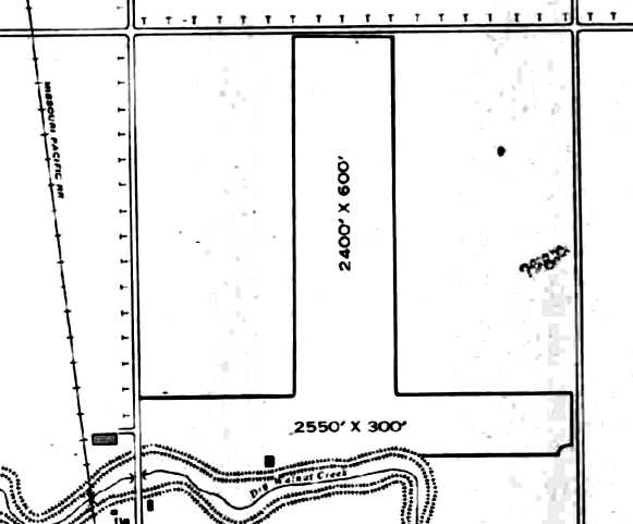
The earliest airfield directory listing which has been located of the 3rd location of Great Bend Airport was in the 1945 AAF Airfield Directory (courtesy of Scott Murdock).
It described Great Bend Municipal Airport as a 50 acre T-shaped property having 2 bare runways, oriented 2,550' east/west & 2,400' north/south.
A single 95' x 39' concrete block hangar was depicted along the southwest side.
The field was said to be owned & operated by private interests.
According to Phillip Schulz, “Number 3 closed when the city bought the Great Bend Army Airfield in 1946 for $1.”
No airfield was depicted at this location on the 1960 USGS topo map.
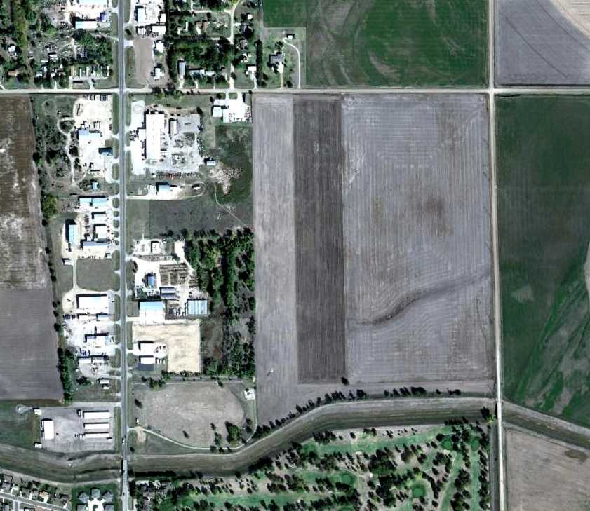
A 10/12/11 aerial view did not show any obvious trace of the 1st & 3rd location of Great Bend Airport.
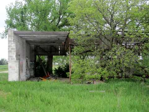
A 2013 photo by Phillip Schulz, who observed “A 3-stall hangar still stands on this site today.
The remaining hangar on [Airport] #3 is just north of the current Great Bend Golf Course.”
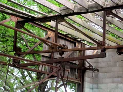
A 2013 photo by Phillip Schulz, who observed “The door system on this hangar is just amazing.
Three stalls with the doors going up into tracks, operated by steel cables running through all those pullies.”
A 2013 photo by Phillip Schulz, “Looking east down the former east/west runway of Airport #3.
The standing hangar is the little white spot in the trees to the right.
The tall cell tower is in the center of the former north/south runway of Airport #3.”
The site of the 1st & 3rd location of Great Bend Airport is located southeast of the intersection of North Main Street & Northeast 20 Road.
____________________________________________________
Great Bend Airport (2nd location), Great Bend, KS
38.36, -98.89 (Northwest of Wichita, KS)
A 1991 USGS aerial photo of the site of the 2nd location of the Great Bend Airport.
Photo of airport while in use has not been located.
According to Phillip Schulz, after the closing of the original location of Great Bend Airport in 1941,
“the city went 5 miles west of Great Bend & built an airport & hangar.
The city purchased a couple of limestone barns & tore them down & hauled the limestone blocks to the airport for the construction of the hangar.
The city paid $140 for the limestone in 1942.”
This location of the Great Bend Airport was in use for an extremely short period of time, however.
According to Phillip Schulz, Great Bend Airport “Number 2 was 3/4 of mile northwest of the Great Bend Army Airfield that was established in late 1942 & 1943.
The Army Air Forces required Great Bend close the #2 airport due to the proximity to the AAF.”
No airfield was depicted at this location on the 1961 USGS topo map.
A 10/12/11 aerial view did not show any obvious trace of the 2nd location of Great Bend Airport.
A 2013 photo by Phillip Schulz of the “Front of Hangar on [Great Bend Airport] #2, some 300' north of the farm house / office.
The hangar is in great shape after some 70 years.
The hangar on Number 2 is 1.75 miles northwest from the center of the current Great Bend Airport (KGBD).”
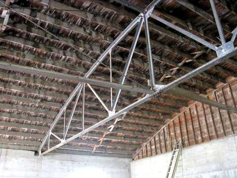
A 2013 photo by Phillip Schulz of the interior of the hangar at the 2nd location of Great Bend Airport.
Phillip observed, “You wonder how they came up with these 60' trusses during wartime.”
A 2013 photo by Phillip Schulz “looking south down what was the original runway.
The hangar is in the trees on the left.”
A 2013 photo by Phillip Schulz of the “farm house used as the office for Airport #2.”
The site of the 2nd location of Great Bend Airport is located at the intersection of Northeast 140th Street & Northeast Flinthills Road.
____________________________________________________
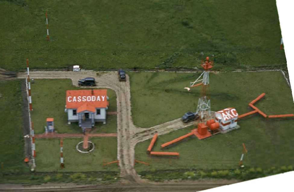
Cassoday Intermediate Field, Cassoday KS
38.03, -96.62 (Northeast of Wichita, KS)
The 1928 Commerce Department Airway Bulletin (courtesy of Jonathan Westerling) depicted Cassoday Intermediate Field as having 2 unpaved runways in an L-shape.
Jonathan Westerling reported, “The government established the Dallas to Kansas City airway between 1925-28 to guide pilots safely across the central US.
At strategic places along the airway, they built 'Intermediate' airfields, equivalent to modern day rest areas for pilots to land at if needed.
One of these intermediate airfields was in the tiny town of Cassoday, KS.
An 8/19/27 Airway Bulletin announced the opening of the Dallas – Kansas City airway.
On this bulletin is the first reference to Cassoday as a newly built 'Class C' intermediate field.”
Jonathan continued, “The 1928 Bulletin #5 (courtesy of David Brooks) incorrectly spelled it as 'Cassody'.
Later that year, the government published an aeronautical bulletin about the airfield which identified it as Site #41 along the airway.
The bulletin further detailed the field as being operated by the Department of Commerce & having 2 grass runways in an 'L' formation 2,600 feet long.
In the northwest corner of the airfield was a 2-million candlepower 24 inch rotating beacon which rotated at 6 RPM.
The newly-built field had few amenities (no fuel, repairs, or telegraph) but did have nighttime lights around the boundary of the airfield.”
Jonathan continued, “By 1931, the starting point of the airway had been changed from Dallas to Amarillo,
and this resulted in a renumbering of the airfields & beacons.
Cassoday changed from Site #41 to Site #34
and, according to the 1931 Bulletin #2 (courtesy of David Brooks) the beacon was upgraded with course lights & a weather teletype (FSS) station was installed on field.
According to 'Airways' (Dale Heister, 1978), the Cassoday FSS was commissioned in February of 1931.”

The earliest aeronautical chart depiction which has been located of Cassoday Intermediate Field
was on the 1933 Wichita Sectional Chart (courtesy of Jonathan Westerling), showing the Cassoday Intermediate Field & its associated airway.
Jonathan Westerling reported, “According to the 1934 Airport Directory Company guide,
the government added emergency fuel on field & the runways had been extended to 3,270’ in length.
This runway extension required relocating the east/west runway so that it intersected with the south end of the north/south runway instead of the north end.
This realignment of the runway configuration left the beacon isolated from the airfield,
so it was moved (or a new one was built) approximately 2,000’ west in the northwest corner of the north/south runway.”
Jonathan continued, “According to the 1938 Bulletin #2, a low frequency radio beacon was added on the site (callsign KCBW at 332 Khz).”
Jonathan Westerling observed, “One of the most detailed photos of a 'modern' airway beacon is this 1940 aerial photo (by David Scheram) of Cassoday.
The radio towers, beacon, and illuminated windsock are supplemented by a sizable building (complete with a front porch!) housing the equipment.”
Jonathan Westerling reported, “The airfield remained mostly unchanged throughout WWII.”
A 10/13/43 aerial view looking north at Cassoday Intermediate Field from the 1945 Army Air Forces directory (courtesy of Scott Murdoch)
showed the revised layout, with the east/west runway at the south end of the field.
Jonathan Westerling observed, “Interestingly, the 1945 AAF Directory (courtesy of Scott Murdoch) listed the airfield as being under private ownership.”
Jonathan continued, “The last mention of the Intermediate Airfield at Cassoday was in the 1947 Directory of Airfields.”
Cassoday Intermediate Field was evidently closed at some point between 1947-51,
as it was no longer listed among active airfields in the 1951 Directory of Airfields (according to Jonathan Westerling).
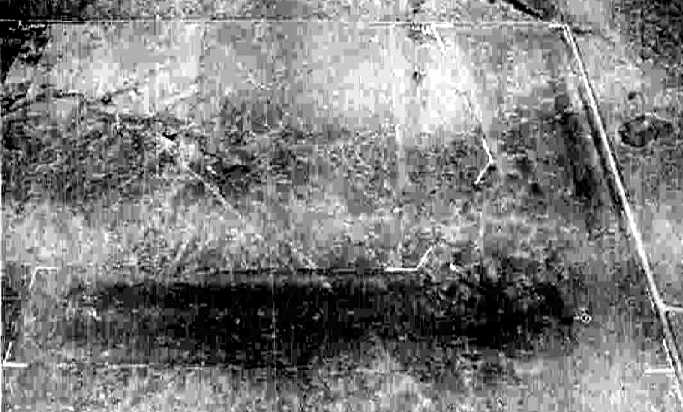
Cassoday Intermediate Field was no longer depicted on the 1955 USGS topo map,
and there was no recognizable trace of an airfield on the 5/4/66 USGS aerial photo.
A 9/5/11 aerial view did not appear to depict any trace of Cassoday Intermediate Field.
The site of Cassoday Intermediate Field is located at the intersection of Northeast 140th Street & Northeast Flinthills Road.
____________________________________________________
Hutchinson Naval Air Station / Yoder Commercial Airport /
Sunflower Gliderport (SN76), Yoder KS
37.93 North / 97.91 West (South of Hutchinson, KS)
A 6/30/43 plan of the "US Naval Air Station Hutchinson, Kansas" (courtesy of Ron Plante).
The runways of NAS Hutchinson were depicted on the left half,
and 4 much smaller runways, labeled "graded & sodded runways", were depicted on the right half.
What was this other field?
More than 2500 acres were chosen as the site for the Hutchinson Naval Air Station in 1942,
according to “Survey Report of World War II Air Bases in Kansas” by Susan Ford.
Construction for the base began in October 1942.
An additional 3,900 acres were leased for up to 20 auxiliary landing fields.
Hutchinson was constructed to provide primary training for the Naval Air Reserve.
Until the station was completed,
the Navy made temporary use of the town's municipal airport (located east of the town).
NAS Hutchinson was commissioned at the end of 1942.
The first training planes used were N2S-3s & N2S-4s,
which were later replaced by N2S-5s.
The earliest depiction which has been located of NAS Hutchinson
was a June 30, 1943 plan of the "US Naval Air Station Hutchinson, Kansas" (courtesy of Ron Plante).
The runways of NAS Hutchinson were depicted on the left half,
and 4 much smaller runways, labeled "graded & sodded runways", were depicted on the right half.
What was this other airfield?
No trace of this smaller airfield were visible in later photos.
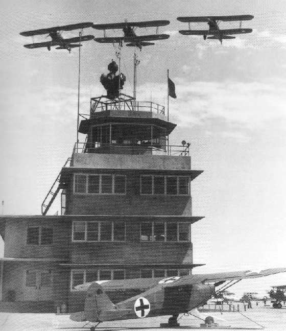
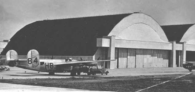
Three Stearman trainers overfly the Hutchinson tower in 1943,
with the station's Piper HE-1 hospital plane in the foreground (National Archives photo).
The station acquired another school training crews of PB4Y-1 Liberator bombers in 1944.
At its wartime peak, Hutchinson had a complement of over 5,000 personnel.
An undated patch for NAS Hutchinson.
The 1944 US Army/Navy Directory of Airfields (courtesy of Ken Mercer)
described NAS Hutchinson as having a 5,000' hard-surface runway.
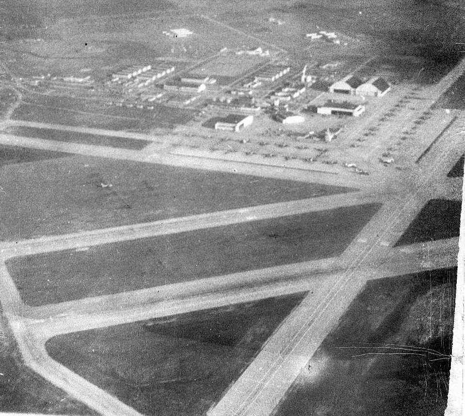
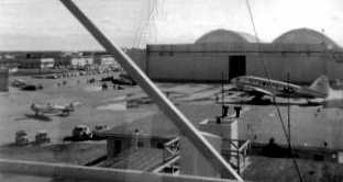
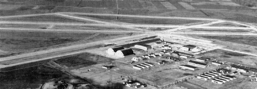
An undated (circa 1940s?) aerial view looking east at Hutchinson, with many aircraft on the ramp.
During WW2, Hutchinson had 3 satellite airfields:
Hutchinson NOLF #1 (4 miles NE), Newton NOLF (3 miles N of Newton),
and Searcy NOLF (near Stillwater, OK).
Other sources indicate that Hutchinson had as many as 18 auxiliary fields at one point during WW2.
A 1945 aerial view of Hutchinson (National Archives photo).
An undated (WW2-era) photo by Bob Zimmerman of a PB4Y-1 Liberator being refueled at Hutchinson (courtesy of Steve Arthur).
"This double hangar was located south of the control tower & on the east side of the flight line & the doors faced to the south.
Today, the only remnants of the hangars are bits of foundation, rebar, and the steel tracks that the doors rode in."
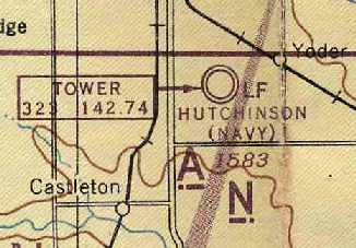
"Hutchinson (Navy)", as depicted on the March 1945 Wichita Sectional Chart (courtesy of Chris Kennedy).
Hutchinson NAS was disestablished at the end of WW2.
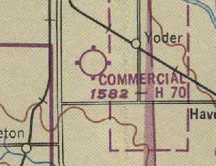
At some point between 1945-49,
the former Hutchinson airfield was reused as a civilian airfield, named "Commercial" Airport,
as depicted on the March 1949 Wichita Sectional Chart (courtesy of Chris Kennedy).
It was depicted as having a 7,000' hard surface runway.
The airfield was abandoned (once again) at some point within the next year,
as nothing at all was depicted at its location
on the October 1950 USAF Wichita Sectional Chart (according to Chris Kennedy).
Cleland McBurney recalled, “The base was surveyed in 1951
by my father who was a Navy Civil Engineer Corps officer
and certified to the Navy Department that the facilities could be reopened with minimal repair.”
NAS Hutchinson was reactivated in 1952 for multiengine training, with P4Y2 Privateers.
A 1952-53 photo by Bob Craig, “looking southeast from the tower,
[at] the large hangar, R4D, SNJ, and in the background an F6F.
There were two F6Fs that were used more for fun.
I was stationed there from September 1952 until December 1953. I was a control tower operator.”
A 1953-54 photo by Cleland McBurney “of one of our PB4Y2s on the wash rack on the south ramp” of Hutchinson.
Cleland McBurney recalled, “I was satationed there in PB4Y-2 training in 1953-54.
The main purpose of stationing the PB4Y-2 Privateer there
was for the purpose of the Navy's advanced training for multi-engine pilots.
The French Navy had a very few of their cadets & officers under the same training.
Several were good friends of mine.
The large wooden hangars were still used when I flew out of there,
and I recall standing personnel inspection in them in the winter out of the cold.
They were large enough to handle several PB4Y-2s at a time.
In addition of the Privateers, the Navy also had a training squadron of P2V-3 Neptunes.
In 1953-54 when I trained there, the Neptunes were the current patrol planes being used in the fleet,
and the Privateers were being phased out.
When I finished training there in February 28, 1954 I received my commission as ensign
and received my wings of gold as a Naval Aviator.”
NAS Hutchinson was depicted on the June 1954 USAF Wichita Sectional Chart (courtesy of Chris Kennedy).
Tom Dailey recalled, "In the 1950s… training took place with PB4Y2 Privateers.
My Uncle William was stationed there during that time.
Bill often spoke of having to work on those Privateers in the winter wind, and freezing his hands as only a Kansas Winter can do.
Oil would turn into sludge, and as 'airy' as a PB4Y2 is (I know), they weren't very warm, either."
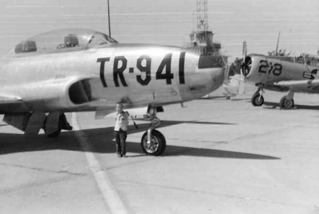
A 1954 picture of Dan Downing in front of a T-33 at an airshow at Hutchinson, with the control tower & an AT-6 in the background.
"I was 5 years old then & don't remember much, but I do remember the Blue Angels were there!
That's probably about the time the airplane bug bit me!"
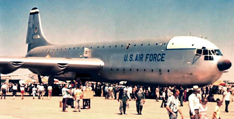
A mid-1950s photo by Richard Swett of the sole prototype of the massive Convair XC-99 transport at a NAS Hutchinson airshow.
Allan Richardson recalled, “I went to an advanced school & studied some of the true multi-engine electronic simulators made by ERCO.
I taught these at my final duty station, which was in Hutchinson - a strange place for a Navy Base in the geographic center of the USA.
I ended up teaching in P2V-7 Operational Flight Trainer trailers. They did an amazing job of simulating a P2-V.
They were a ball to teach & challenging to maintain.”
According to William Gilliland, the Kansas National Guard's 117th Fighter Inceptor Squadron
flew F-80 Shooting Stars out of Hutchinson Naval Air Station in 1957.
William recalled, “The Navy moved out in 1958, and the base soon thereafter became Hutchinson Air National Guard Base.
Also in 1958, we made the transition to B-57 Canberras (of which, we would fly in various forms for the next 20 years),
with the mission of photo reconnaissance.”
A circa 1958-59 photo of a Martin B-57 Canberra
of the Kansas Air National Guard's 177th Tactical Reconnaissance Squadron (courtesy of William Gilliland) at Hutchinson.
William observed, “If you look closely enough, you’ll find part of the Hutchinson Naval Air Station printing on the tower,
and I can’t image the Air Guard leaving that there for long.”
An 11/2/59 "Strategic Air Command, Wichita, Kansas, McConnell AFB, Base Layout Plan, Hutchinson A.S." (courtesy of Ron Plante).
Ron observed, “Presumably this reflects Air National Guard use.”
The miniature airfield depicted on the 1943 plan was no longer depicted at all.
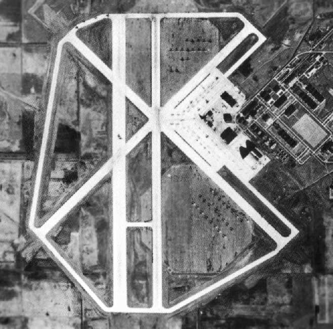
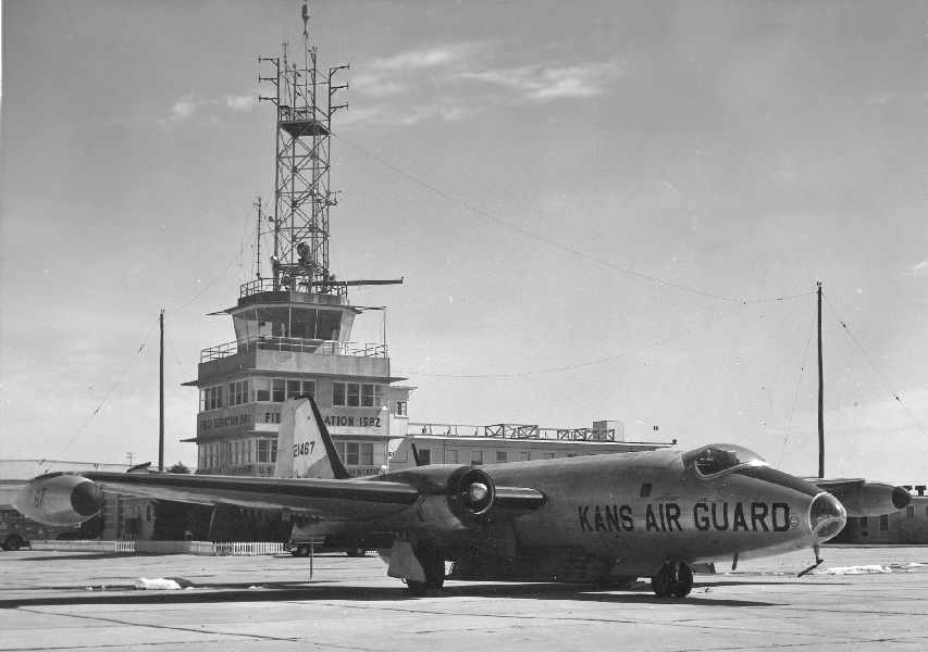
A circa 1959-60 aerial view looking west at Hutchinson Air National Guard Base (courtesy of William Gilliland).
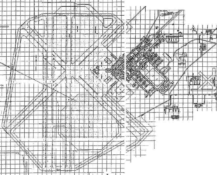
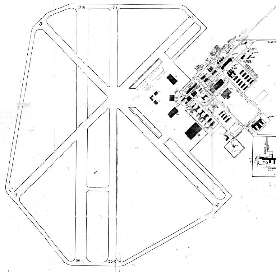
"Hutchinson ANG" was depicted in the 1960 Jeppesen Airway Manual (courtesy of Chris Kennedy)
as having a total of four 7,000' paved runways,
as well as numerous taxiways, the two large octagonal landing mats, a large ramp, and several hangars.
The airfield continued to be labeled "Hutchinson ANG"
on the May 1962 Wichita Sectional Chart (courtesy of Chris Kennedy) & the 1966 USGS topo map.
Kevin Knoll recalled, “I went to grade school in Hutchinson in the 1960s while my dad was with the 190th KANG at Sunflower.
One memorable Saturday, age 5, Dad took me on a tour.
We went up to the tower, I got a ride in a fire truck, and I got to ride along in the C-47 they taxied out for a maintenance run. Different times.”
Steve Hurst recalled, “Once following a very heavy snow storm, the station's helo landed at the end of our street to pick up the station Commanding Officer.
He lived in our neighborhood & couldn't get out the base due to the heavy snow.
The other memory is from early 1960s when the field was home to a KANG RB-57 squadron.
My next door neighbor's son, I went with him & his father, a maintenance chief, to watch a practice night photo run with 'flash bulb' -like flares fired from the bottom of the aircraft.
Starting the RB-57 required the insertion of a large black powder shell into a chamber in the engine.
When fired the blast provided the initial thrust to start the engine. From the outside it looked the engine blew up with A LOT of black smoke.”
According to William Gilliland, “The Air National Guards’ 117th Tactical Reconnaissance Squadron
(becoming the 190th TRG upon expansion in 1962)
was the sole operator of the base until 1967, when we were transferred to Forbes Field in Topeka.
The base at Hutchinson was closed at that time.
The State of Kansas considered it for a possible prison site, but that fell through.”
The Hutchinson airfield was labeled "Hutchinson ANG (Closed)" on the June 1968 Wichita Sectional Chart (courtesy of Chris Kennedy)
and the 1971 Wichita Sectional Chart (courtesy of Vince Granato).
At some point between 1971-74,
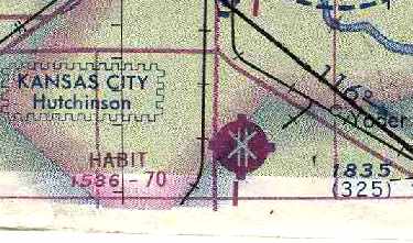
the former Hutchinson airfield was apparently reopened (once again) as civilian airfield, named "HABIT" Airport,
as that is how it was labeled on the May 1974 Wichita Sectional Chart (courtesy of Chris Kennedy).
According to Dan Downing (who grew up in Hutchinson), H.A.B.I.T. was the Hutchinson Air Base Industrial Tract,
"where Hutchinson used the large hangar buildings to attract businesses such as Collins Industries,
Bella Vista Manufactured Homes, Eaton Metal Tanks, Pioneer Seeds, etc.
Many of the large wooden structures burned to the ground at various times in the late 1960s & 70s."
Tom Dailey recalled, "In 1974, I was at Hutch' for a weekend of SCCA racing.
Per my Uncle's descriptions... the wind NEVER quit, and the rain was pretty intense as well.
Having been in the US Navy as a Radioman, I'll not forget the smells, sights, and sounds of the old terminal building... late at night.
We slept in the crew-ready quarters and about 0300 I couldn't sleep...
got up and just sat out in the briefing area…
you could almost hear the clipboards being shuffled, the clink of parachute harnesses,
and the chatter of aircrews preparing for an early-morning navigation mission.
It was very eerie, indeed.
Most of the stenciled notices were still on the bulkheads (walls),
and that good old lead-based Navy grey paint was intact and in good shape.
It was a trip back in time."
Kevin Knoll recalled, “Sunflower had a commercial skydiving operation, Sky Sports, operating there from about 1975-84. I started jumping there in 1977.”
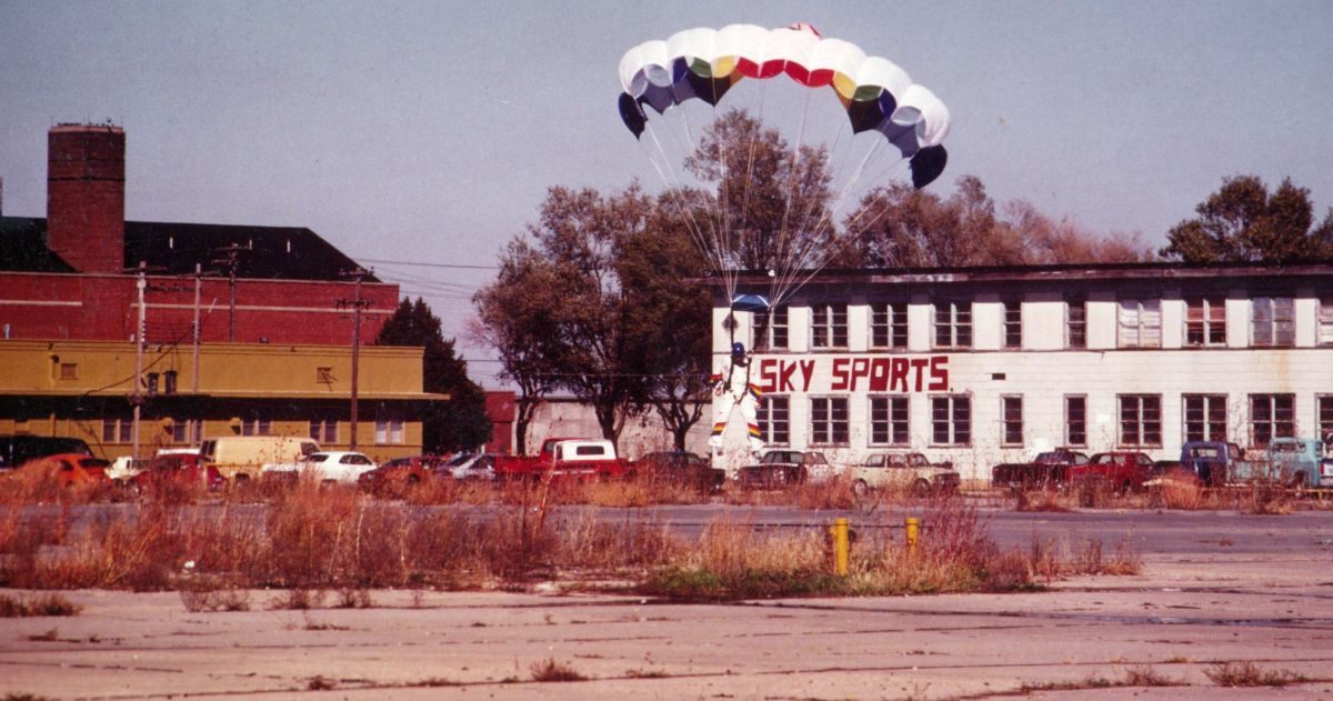
A circa 1981-84 photo by Kevin Knoll of a parachutist landing in front of the Sky Sports building at Hutchinson.
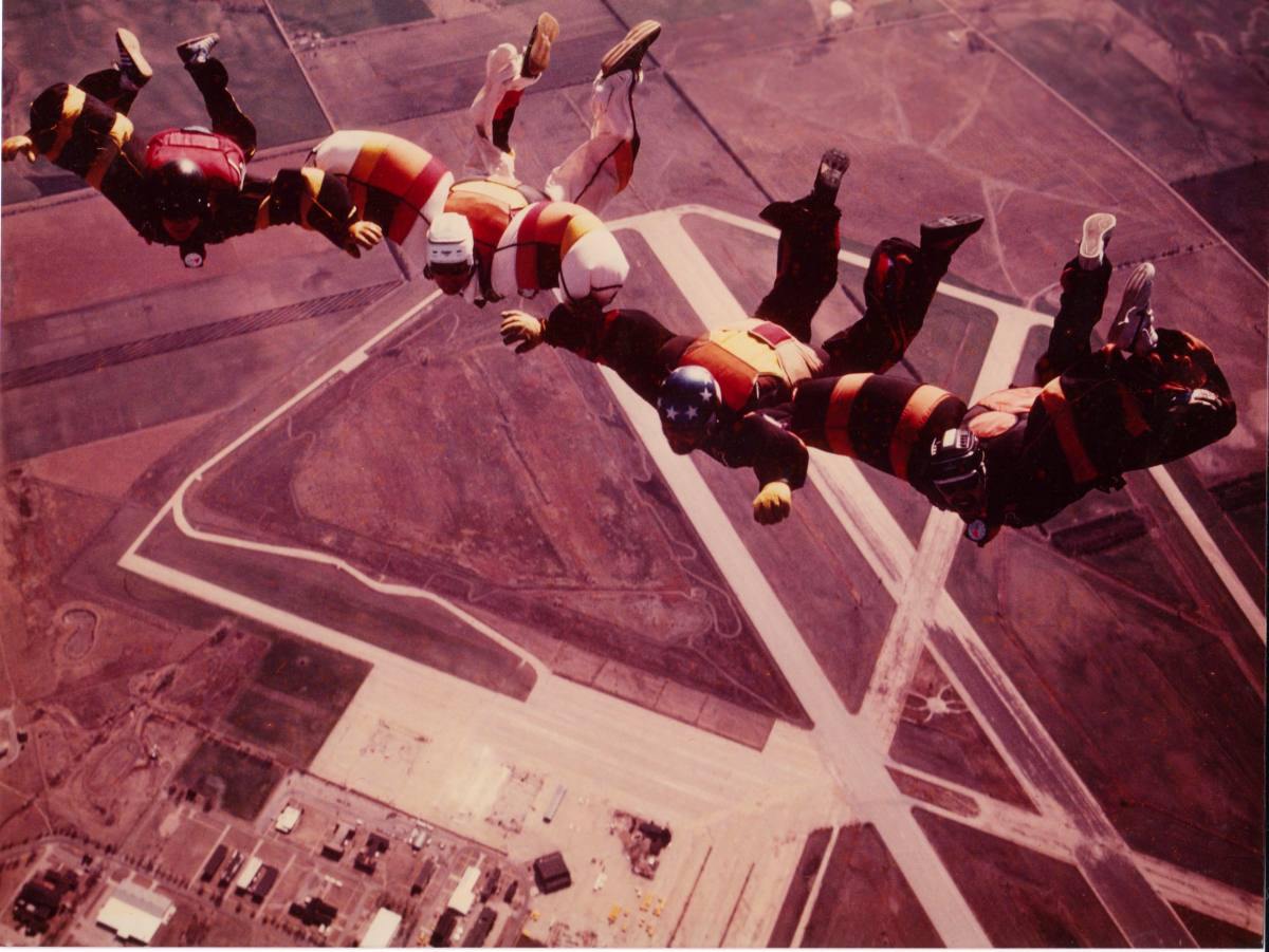
A circa 1981-84 photo by Kevin Knoll of skydivers free-falling over Hutchinson.”
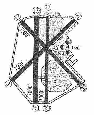
In the 1995 USGS aerial photo, the 2 parallel Runways 17L/35R & 17R/35L appeared to remain in fine condition,
as well as the western halves of Runways 3/21 & 12/30.
By 1998, the Hutchinson airfield was being operated as a private glider airport, the "Sunflower Gliderport",
which is ironic, given the airfield's large size.
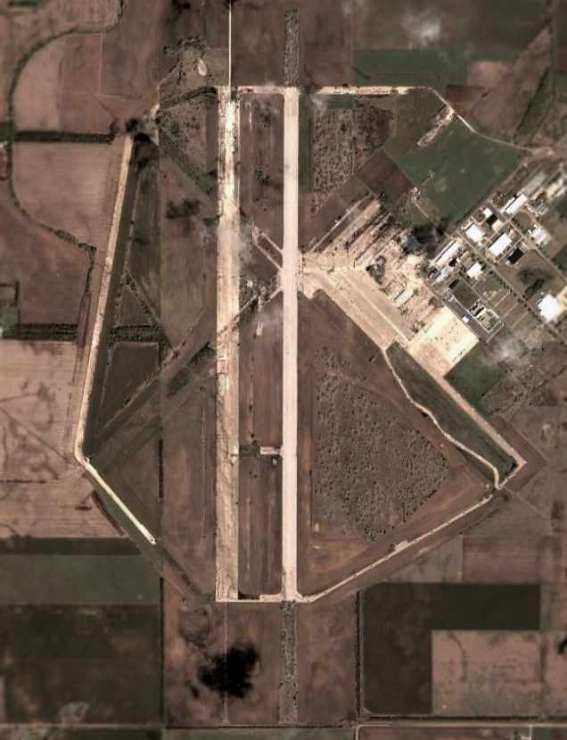
A 2002 aerial photo showed that the remaining pavement on the former Runways 3/21 & 12/30
had been removed at some point between 1995-2002.
Runway 17L/35R appeared to be the only runway to still be maintained.
The pavement of Runway 17R/35L remained intact, but in significantly worse condition.
Steve Arthur reported in 2003 that "Currently the base serves as an industrial park for Collins Industries
on the east side of the base (they make ambulances & school buses)
as well as the Kansas Law Enforcement Training Center on the west side.
The runway is used for emergency vehicle training."
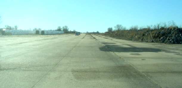
A 2003 photo by Terry Martin of the remains of a runway at Hutchinson.
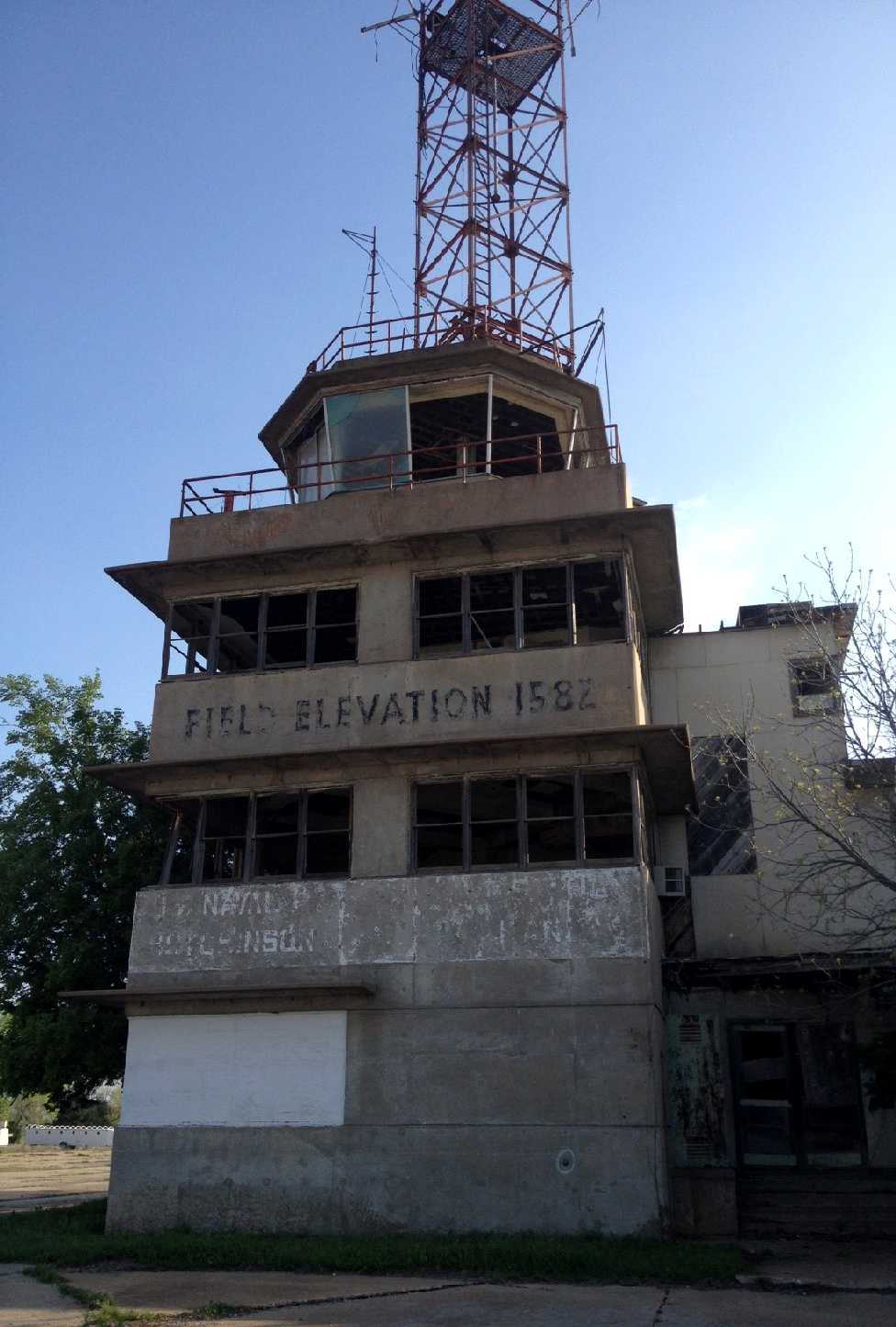
A 2003 photo by Terry Martin of the former control tower & other buildings which remain standing at Hutchinson.
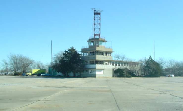
A 2003 photo by Terry Martin of the former control tower which remains standing at Hutchinson.
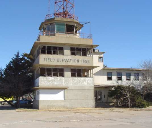
A 2003 photo by Terry Martin of the former control tower which remains standing at Hutchinson.
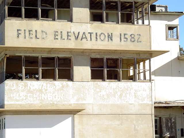
A 2003 photo by Terry Martin of the former control tower which remains standing at Hutchinson.
Terry Martin recalled, "My dad was stationed at NAS Hutchinson.
While visiting family last week [in 2003] that still lives in Hutchinson we visited the old air base.
What a site. The tower is still standing, but most of the windows are missing,
and the ceiling & floors are in bad shape.
The present owner told us it was OK to look around so we did."
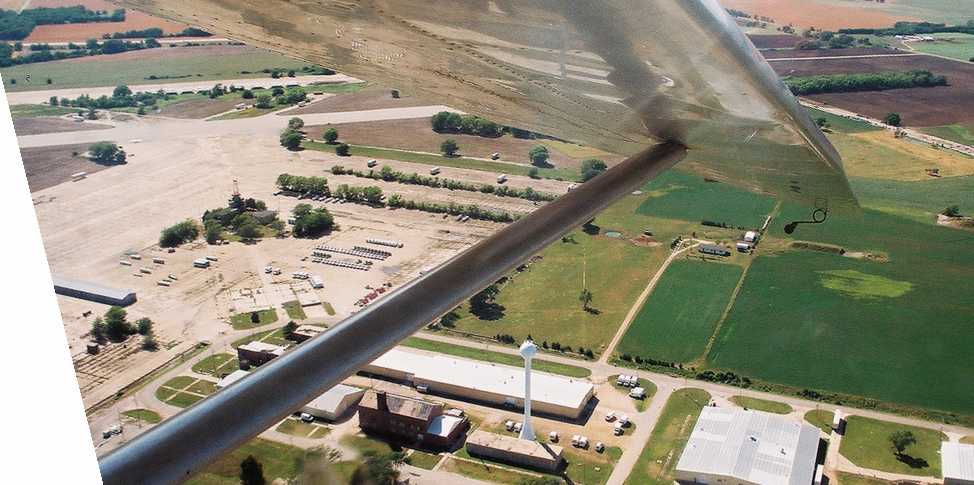
A May 2004 aerial view by Randy Colby looking west at the Sunflower Gliderport, taken from a Schweizer 2-33 glider.
Laura Laster reported in 2004 that "Sunflower Field" was described in a book called "Ghosts of the Air" by Martin Caidin.
J. Godwin reported in 2004, "Of the base itself most of the buildings have been razed
except for the Link Trainer, parachute packing, commissary, tower, and administration buildings.
The large hangar foundations are still there.
I found the steps that once led up to the pool building still in good shape.
An ambulance conversion business has built their factory right on top of the old foundation."
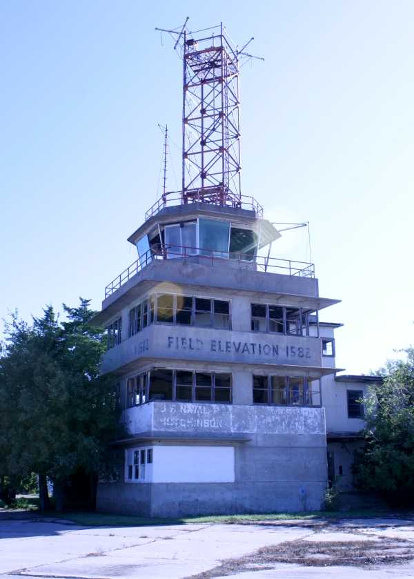
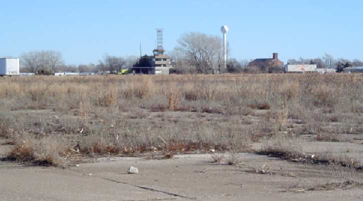
A 9/15/08 photo by Susan Ford of the former NAS Hutchinson control tower.
A 2012 photo by Josh Peach of the NAS Hutchinson control tower.
Josh observed, “From what I could see here, the condition had deteriorated a lot from the pictures from 2008. The tower had just one window pane in it.”
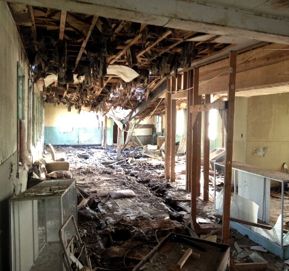
A 2012 photo by Josh Peach of the interior of the NAS Hutchinson control tower.
Josh observed, “Inside the first floor, I think this used to be office space. But the roof is caved in about halfway back & is being held up with a couple 2 x 4s.”
…………………………………………………………………………………….
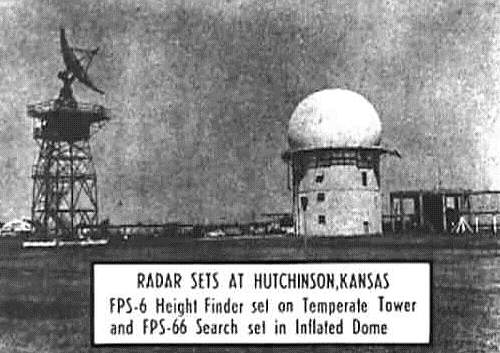
Undated photo of Hutchinson AFS radars.
Adjacent to the Hutchinson airfield to the southeast was a property known as Hutchinson Air Force Station (P-47),
which was established in the 1950s as an early-warning radar installation.
According to Jonathan Westerling a February 15, 1972 document entitled
"Real Estate, Hutchinson Air Force Station (Z-47), Hutchinson Air National Guard Base, Military Reservation"
appears to show that “most of the Air Force Station facilities were in the former Naval Air Station cantonment area.”
The radar site is still in use today by the FAA.
____________________________________________________
Walker Army Airfield / Victoria-Pratt Airfield, Walker KS
38.94 North / 99.06 West (Northwest of Wichita, KS)
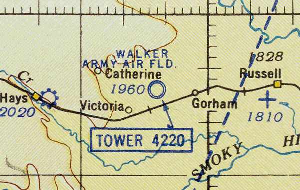
Walker AAF, as depicted on the February 1943 8M Regional Aeronautical Chart (courtesy of Chris Kennedy).
A total of 1,888 acres of land were purchased from local owners & leased from the nearby Union Pacific Railroad
to constructed a satellite field to assist Smoky Hill AAF (in Salina, KS)
in the training of heavy bomber crews, primarily B-17s & B-24s.
Construction began on September 14, 1942.
Originally, the field had one hangar.
Three runways were constructed, each measuring 8,000' x 150', along with a 375' x 300' apron.
It was known for a time as Hays-Walker Airfield.
Walker was further expanded in 1943 to encompass a total of 1,888 acres,
to prepare for its new mission as one of 4 fields in Kansas intended to train B-29 bomber crews.
The earliest aeronautical chart depiction of Walker AAF which has been located
was on the February 1943 8M Regional Aeronautical Chart (courtesy of Chris Kennedy).
Four additional hangars were added in 1943,
bringing the base to its ultimate complement of 5 hangars.
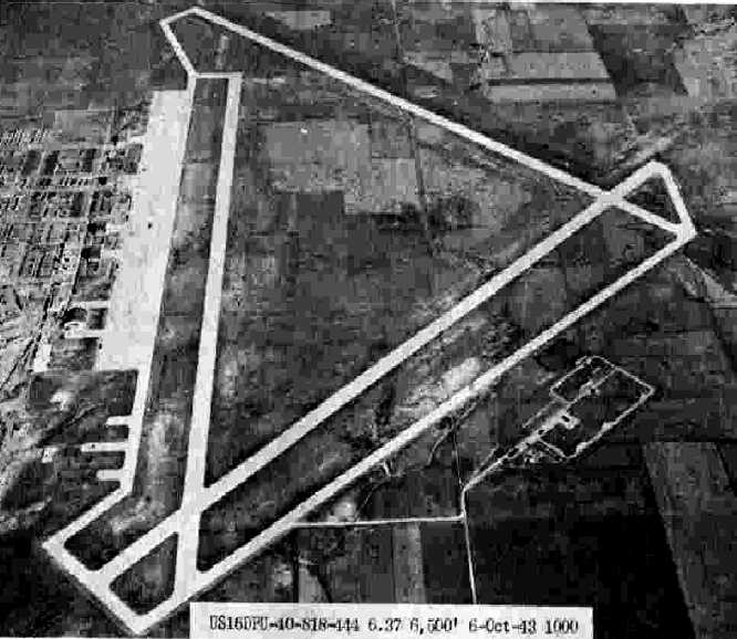
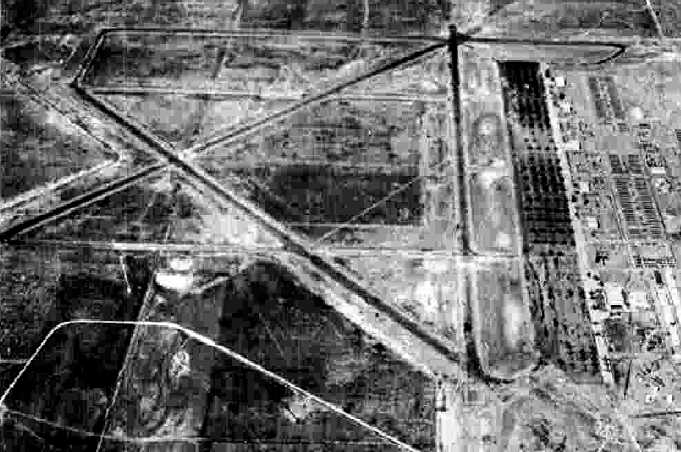
The earliest photo which has been located of Walker AAF
was a 10/6/43 aerial view looking north from the 1945 AAF Airfield Directory (courtesy of Scott Murdock).
It depicted Walker as having 3 paved runways, a huge paved ramp, and several hangars.
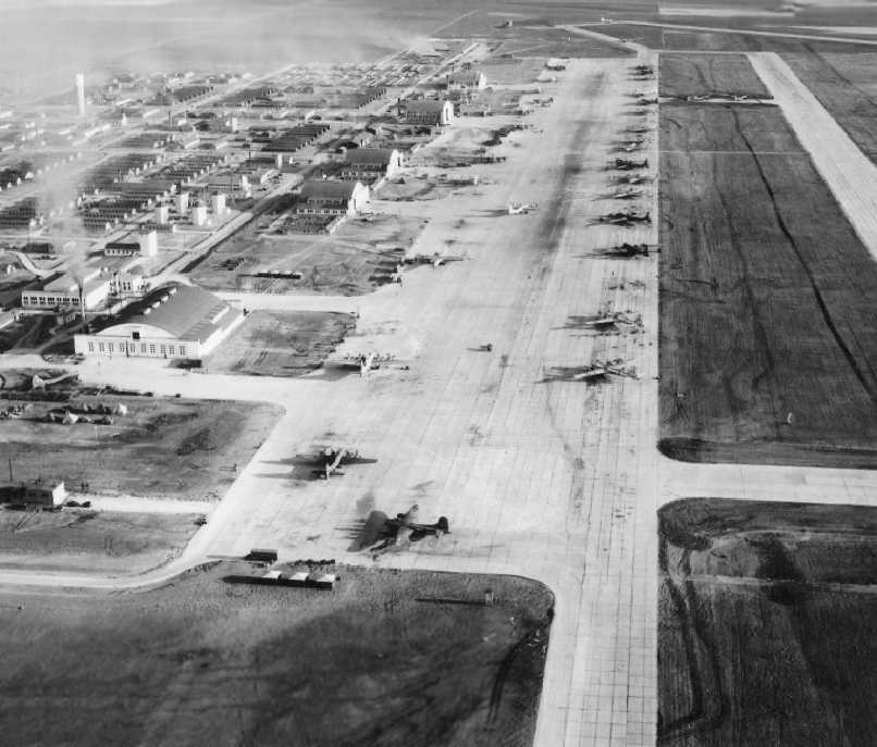
A circa 1944 aerial view looking north along the Walker ramp (courtesy of Keith Goetz)
showed large numbers of B-29s & 5 large hangars.
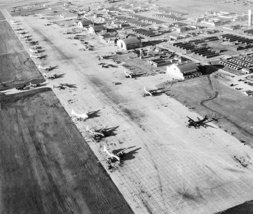
A circa 1944 aerial view looking southwest along the Walker AAF ramp (courtesy of Keith Goetz),
showing large numbers of B-29s, 5 large hangars, and the control tower.
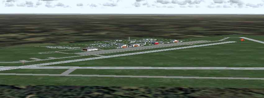
A recreation of the WW2-era configuration of Walker AAF via Flight Simulator scenery created by Robert Pearson.
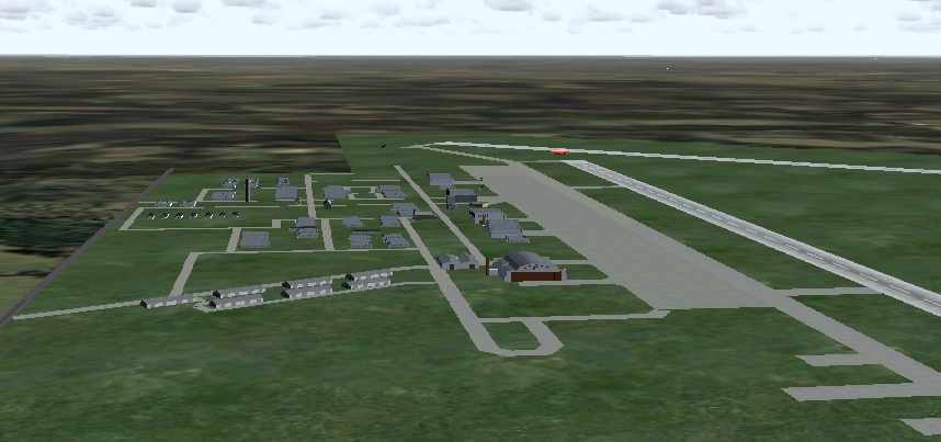
A recreation of the WW2-era configuration of Walker AAF via Flight Simulator scenery created by Robert Pearson.
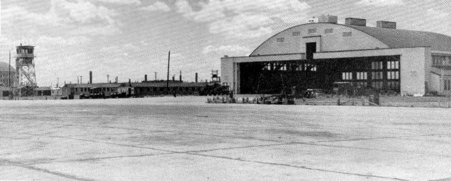
A WW2-era view of a Walker hangar & control tower (courtesy of Keith Goetz).
The 1944 US Army/Navy Directory of Airfields (courtesy of Ken Mercer)
described Walker AAF as having a 6,800' hard-surface runway.
Walker AAF was still depicted as an active airfield
on the March 1945 Salina Sectional Chart (courtesy of Chris Kennedy).
The 1945 AAF Airfield Directory (courtesy of Scott Murdock) described Walker AAF
as a 1,760 acre irregularly-shaped property having 3 concrete runways.
The field was said to have 5 concrete hangars, the largest being a 202' x 145' structure.
The field was said to be owned by the U.S. Government & operated by the Army Air Forces.
In 1946 Walker was put on inactive status,
and was transferred to the District Engineers, Kansas City.
It was later known to the Air Force as Victoria Air Force Auxiliary Field,
although apparently no Air Force personnel were assigned there in the post-war period.
The hangars were used for grain storage & the runways for drag racing during the 1940s & 1950s.
From 1948-1952, crop-dusting planes were stored in the old Maintenance hangar.
It was labeled as "Victoria AF" on the March 1949 Salina Sectional Chart (courtesy of Chris Kennedy)
and the June 1954 USAF Salina Sectional Chart (courtesy of Chris Kennedy),
both of which depicted the field as having a 8,000' hard surface runway.
In December of 1958 the government held an auction to sell the many acres of the former airfield.
It was purchased by Don & Ida Pratt.
A 5/25/59 USGS aerial view depicted the massive aviation infrastructure which remained at the site of Walker AAF.
Two Walker AAF hangars burned down in 1959.
By the time of the April 1965 USAF Salina Sectional Chart (courtesy of Chris Kennedy),
"Victoria-Pratt" was depicted as a private airfield.
All three runways were depicted on the chart,
but the Aerodromes table said that only one 8,000' concrete runway was used,
and the remarks said: "Private. North/South only runway open. Use caution."
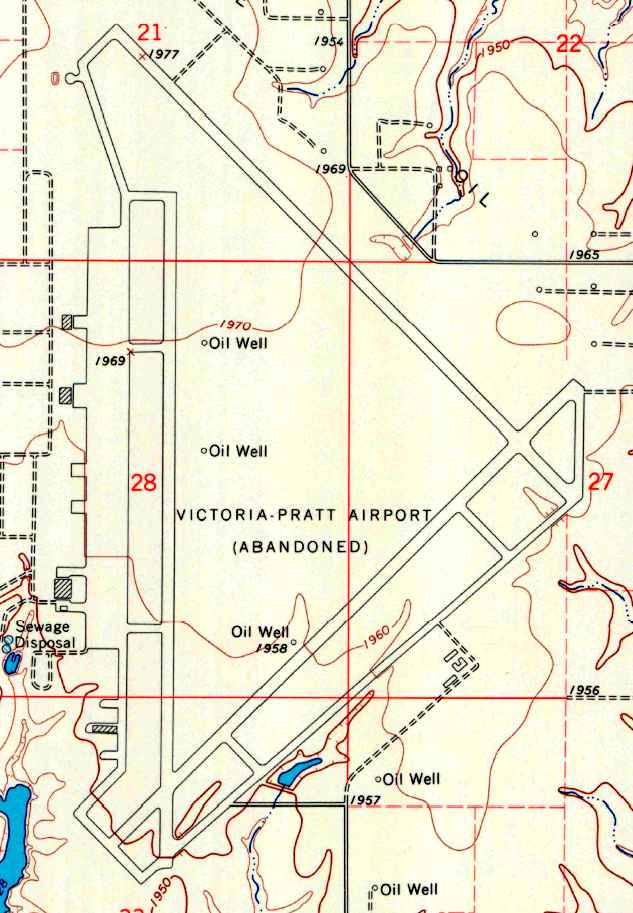
The 1967 USGS topo map depicted the “Victoria-Pratt Airport (Abandoned)”
as having 3 paved runways, taxiways, a ramp, and 3 hangars.
The former Maintenance hangar burned down in 1967.
The Victoria-Pratt Airfield was apparently abandoned at some point between 1965-68,
as nothing was depicted at this location on the September 1968 Salina Sectional Chart (according to Chris Kennedy)
and it was not listed among active airfields in the 1968 Flight Guide (courtesy of Robert Levittan).
It was depicted as an abandoned airfield
on the 1971 Wichita Sectional Chart (courtesy of Vince Granato).
In 1971, the Air Force leased the NE/SW runway for a study dealing with explosive cratering.
However, the current owner of the site has said the study had been done shortly after WW2.
The craters are still visible & vegetation & trees have voluntarily grown in the crater holes.
Keith Goetz confirmed, “The runways were bombed in the early 1970s.
We live less than 2 miles away & listened to the explosions every day when I was a freshman in high school.”
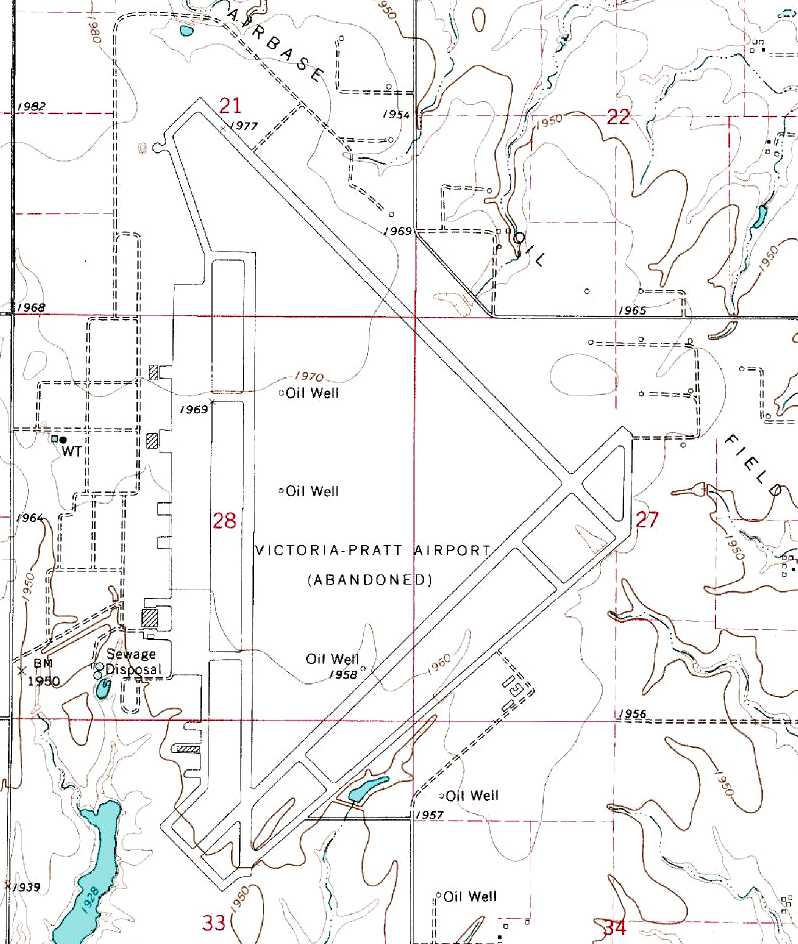
The 1981 USGS topo map depicted the “Victoria-Pratt Airport (Abandoned)”
as having 3 paved runways, taxiways, a ramp, and 3 hangars.
The Walker property was sold in 1991 to Wilfric Karlin for around $2 million.
In 1992 government personnel and property owner Wilfric Karlin performed a walkover.
It was determined there was still hazardous waste left behind from the Army,
with 0.30 & 0.50 caliber casings & bullets found on the former target range at the north end of the site.
The sewage treatment system in the southwest part of the field was still present although inoperable.
All pollution was cleaned up with government funds reserved for such operations after the walkover.

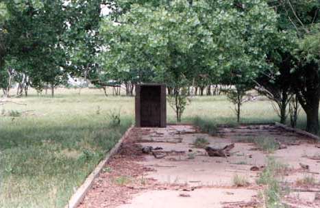
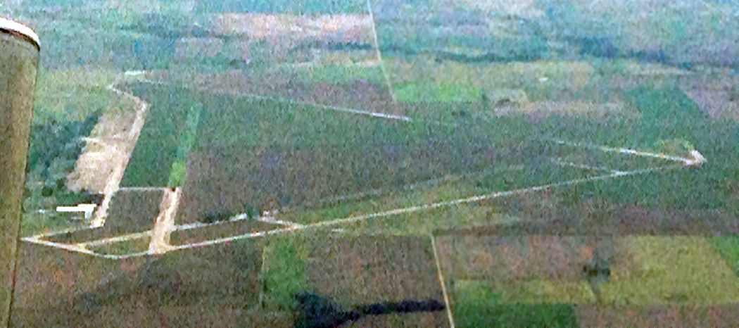
A 2001 photo by Steve Arthur of what was previously the main entrance gate of Walker AAF.
The grassy area in the middle of the photo is where the gate shack stood.
The base headquarters was located just beyond the water tower & to the right.
The road which leads into the base was designated "B" street.
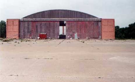
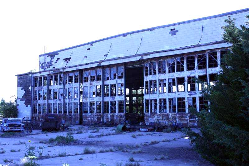
A 2001 photo by Steve Arthur looking west at the front of Hangar "B".
"If you look close, you'll notice a speck in a blue shirt to the right side of door opening
and near the large sheet of metal, that speck is me.
To give you an indication as to how large these hangars are, I'm six foot two inches tall.
I was told that these hangars were capable of housing two B-29s.
Walker also had a maintenance hangar which was capable of housing four B-29s.
The maintenance hanger no longer stands due to a senseless act of arson.
Two other of Walker's hangars have met the same fate in recent years."
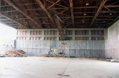
A 2001 photo by Steve Arthur of the interior of Hangar B.
The majority of the buildings on Walker were either of wood frame or poured concrete construction.
What little brick that was used, was of lower quality & was known as 'War Brick'.
When Walker & the other B-29 bases were constructed,
it was under the assumption that they would not be needed more than five years.
Fifty six years later most are still standing."
which was used to secure the sensitive Norden bombsights.
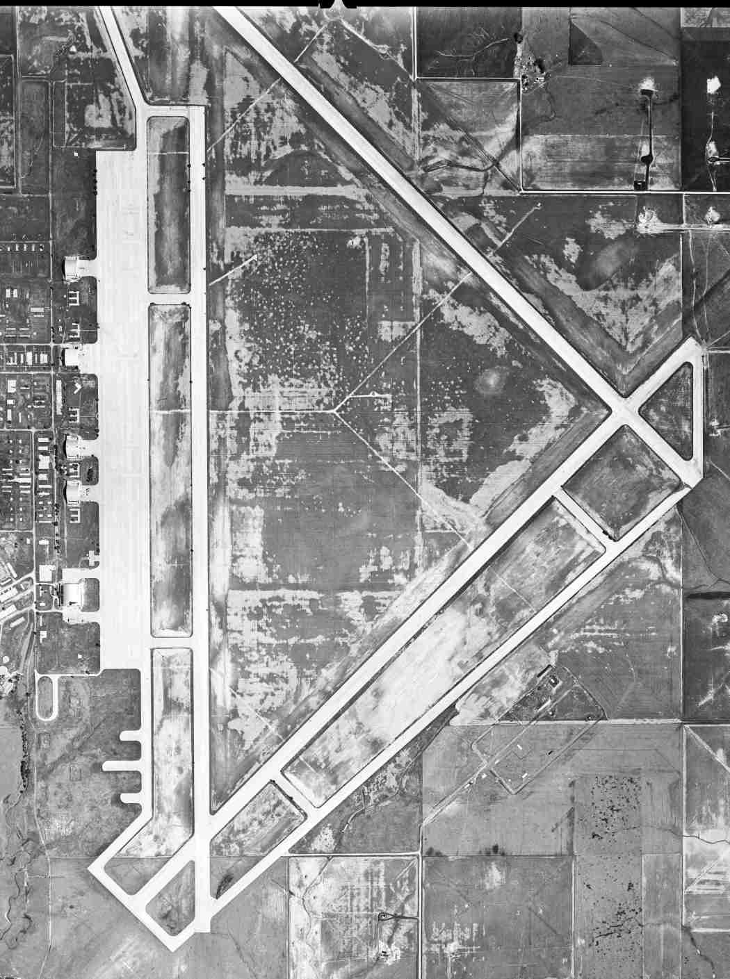
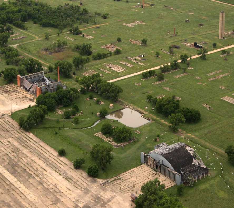
A 2002 aerial view looking north at Walker AAF.
A 2002 aerial view by Dan Wright looking southwest at the the ramp & remaining hangars at Walker AAF.
A 2002 aerial view by Dan Wright looking northwest at the craters on the NE/SW runway.
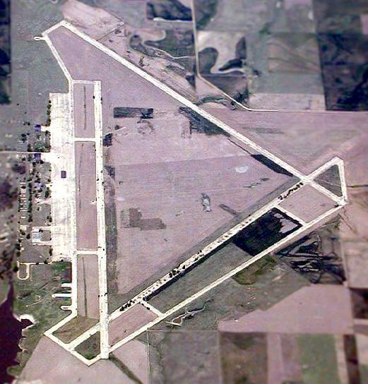
Walker is a very large airfield to be completely abandoned:
consisting of 3 runways (each approximately 8,800 ft long),
taxiways & a large paved ramp area, all still in very good condition
(except for the aforementioned test craters in the NE/SW runway).
Two original military hangars still stand alongside the ramp.
The site is presently used for agricultural purposes.
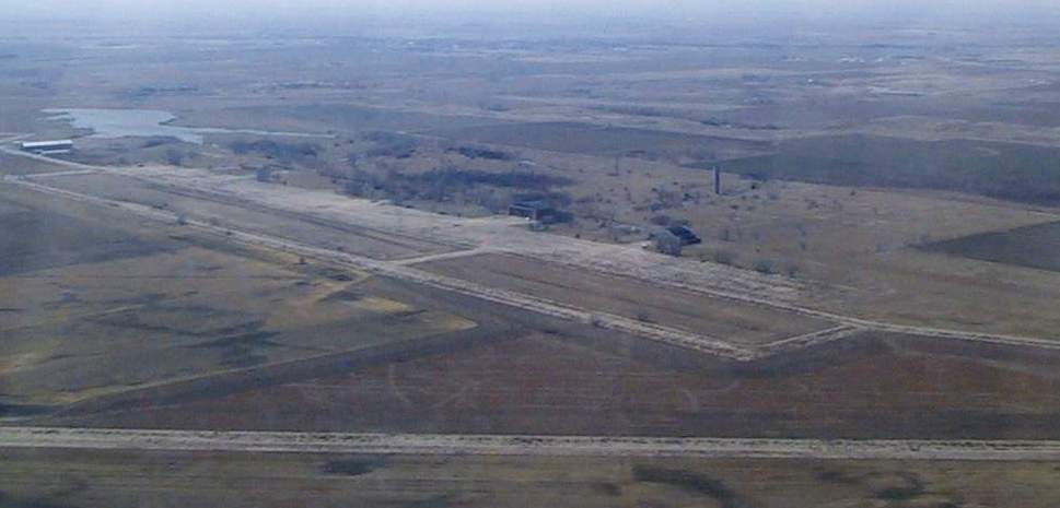
Walker resident Keith Goetz reported in 2008, “As of a few months ago,
they've started grinding up the runways & selling the aggregate for such things as driveways.
The hangars collapse a little more everyday, and it is a shame it was never preserved.”
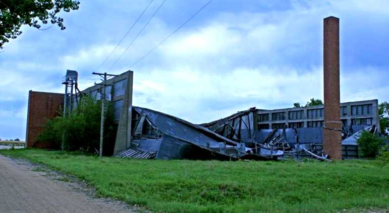
A June 23, 2008 photo by Susan Ford of the ruins of a Walker hangar.
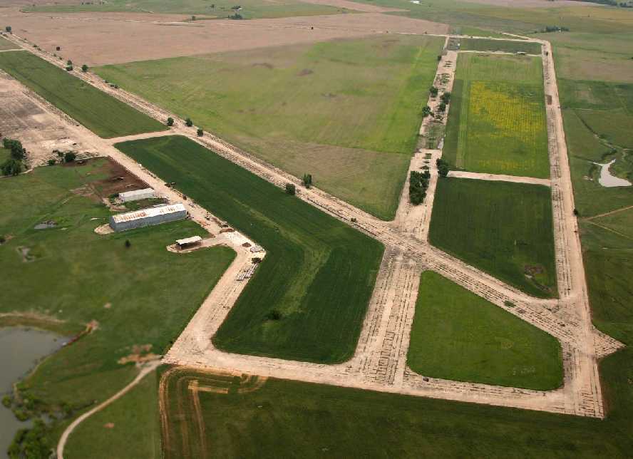
A June 4, 2009 aerial view by John English looking northeast at the massive Walker runways, taken from a “mighty 152”.
A June 4, 2009 aerial view by John English looking southwest at the remains of 2 Walker hangars.
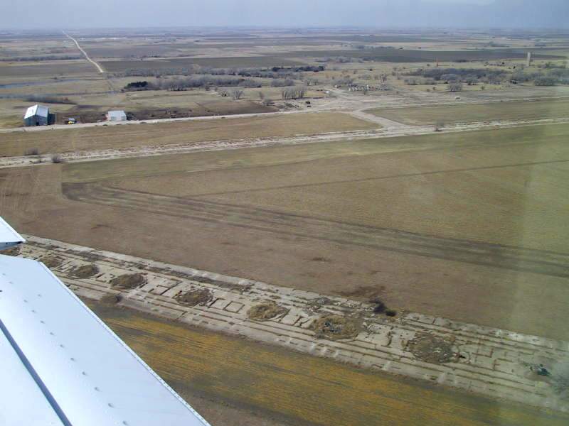
An August 2014 aerial view by Steve looking south at the remains of Walker AAF. Steve observed, “Most runway surfaces & hangars are gone.”
____________________________________________________
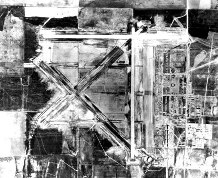
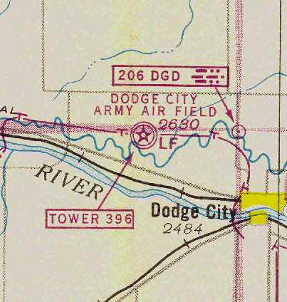
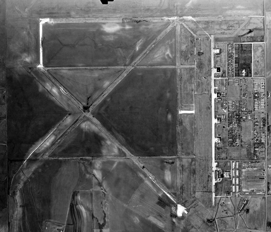
Dodge City Army Airfield / Ford County Airport, Dodge City, KS
37.798, -100.117 (Northwest of Wichita, KS)
A 1943 aerial view showing Dodge City AAF while under construction (courtesy of Patrice Laverdet).
Dodge City AAF was located 6 miles northwest of the town of Dodge City.
Construction of the base commenced on August 6, 1942,
according to “Survey Report of World War II Air Bases in Kansas” by Susan Ford.
The Army Airfield was built for the 70,000 Pilot Training Program,
to train pilots & crews of medium bombers, primarily B-25s.
According to an Army Corps of Engineers report, the Dodge City AAF base encompassed a total of 2,560 acres.
Dodge City was also used during WW2 to train French aircrews (as covered in a French-language web site).
A 5/15/43 AAF list of airfields of the Gulf Coast Training Center (courtesy of Ron Plante)
described Dodge City as having 4 asphalt 6,500' runways & one satellite field: Auxiliary #4A.
A 10/7/43 aerial view looking north from the 1945 AAF Airfield Directory (courtesy of Scott Murdock)
depicted Dodge City AAF as having 3 paved runways, a huge paved ramp, and several hangars.
A series of photos of Dodge City AAF in 1943.
The earliest chart depiction of Dodge City AAF which has been located
was on the February 1944 Wichita Sectional Chart (courtesy of Chris Kennedy).
The 1944 US Army/Navy Directory of Airfields (courtesy of Ken Mercer)
described Dodge City AAF as having a 6,500' hard-surface runway.
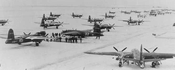
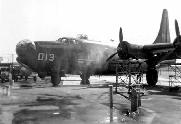
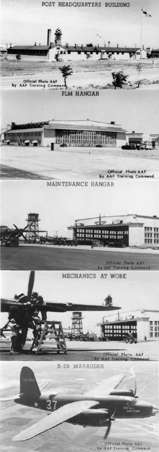
A circa 1940s photo of B-26 Marauder bombers on the snow-covered apron of Dodge City AAF (courtesy of Rex Ricks).
They were used by the base's advanced twin-engine school.
"Dodge City AAF" was still depicted as an active military airfield
on the March 1945 Wichita Sectional Chart (courtesy of Chris Kennedy).
The 1945 AAF Airfield Directory (courtesy of Scott Murdock) described Dodge City AAF
as a 2,536 acre square-shaped property having 3 bituminous 6,500' runways.
The field was said to have 5 wooden hangars, the largest being a 202' x 162' structure.
The field was said to be owned by the U.S. Government & operated by the Army Air Forces,
and to have one auxiliary field: #4 Jetmore Field.
The Army is reported to have departed Dodge City AAF in 1945.
However, it was still labeled "Dodge City AFB" on the March 1949 Wichita Sectional Chart (courtesy of Chris Kennedy).
It was depicted as having a 6,500' hard-surface runway.

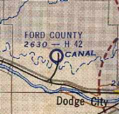
At some point within 1949 the field apparently transitioned to a civilian airport,
as it was listed as "Dodge City Municipal Airport (Ford County)"
in the 1949 KS Airport Directory (courtesy of Chris Kennedy).
It was depicted as having four 6,500' bituminous runways
and a 5,250' long concrete ramp along the east side of the field.
Strangely, no hangars were depicted in the airfield diagram in the 1949 airport directory -
had they all been removed by this time?
The airport was not attended, and the manager was listed as William Meade.
"Ford County" was still depicted on the on the October 1950 USAF Wichita Sectional Chart (courtesy of Chris Kennedy)
as having a 6,500' hard surface runway.
Within the next 4 years the airport apparently lost some of its runway length,
as the June 1954 USAF Wichita Sectional Chart (courtesy of Chris Kennedy)
depicted Ford County's longest runway as having gone down to 4,200'.
A 12/19/54 USGS aerial photo did not show any aircraft visible at Ford County Airport.
Ford County Airport was not depicted at all on the 1955 USGS topo map.
Ford County Airport was evidently closed at some point between 1954-62,
as it was depicted as "Abandoned airport" on the May 1962 Wichita Sectional Chart (courtesy of Chris Kennedy).
The airfield & its buildings were subsequently reused for a variety of commercial purposes.
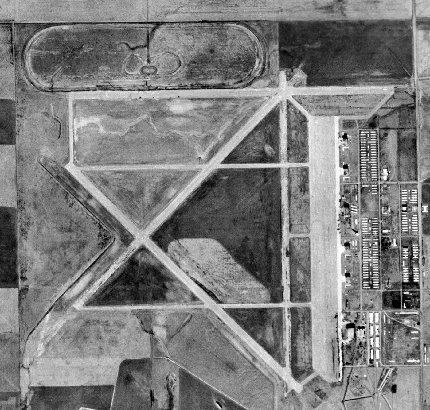
The extensive aviation infrastructure of Dodge City AAF had deteriorated quite a bit by the time of a 3/6/65 USGS aerial photo.
Chuck Regnier recalled, “From 1976 I lived in Dodge City.
I was in the truck driving class which was located at the old airfield.
At that time there were 3 hangars, two unknown buildings & the old firehouse still standing.
We used the parking areas & taxiways in front of the hangars,
once in a while we would run up & down the southeast/northwest runway.
The others were in such poor condition that the trucks would have been severely damaged had we ventured out on them.
Also the guard shack at the old maingate was still standing. This disappeared in 1974.
In 1975 while employed as a firefighter for the Ford County Fire Department
we were dispatched to the airfield on a structural fire.
The old firehouse was on fire. It had been turned into a residence.
Some of the original wiring caught fire. The building was later demolished.”
The runways of the former Dodge City airfield were not depicted at all on the 1984 USGS topo map,
just the adjacent street grid.
As seen in the 1991 USGS aerial photo, 4 paved runways (the longest is 7,000') & taxiways still existed,
but were being progressively removed for farming.
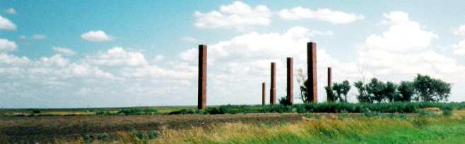
A 1999 photo by Steffani Day of the some of the remaining erect structures at the former Dodge City AAF - brick chimneys.
Dodge City resident Steffani Day reported in 2003 that the brick chimneys pictured above
"(and a few old building foundations) are the only part of the facility that a passerby can get close to.
The hangar and, I assume, the runways have been gated by the current owner."
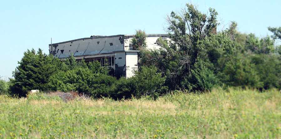
A 2007 photo by Scott Murdock of a Dodge City hangar which remains standing, heavily overgrown.
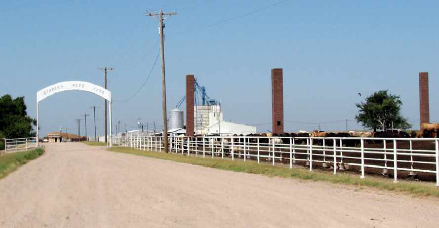
A 2007 photo by Scott Murdock of a the entrance to the Stanley Feed Yard, which occupies the site of Dodge City AAF.
Brick chimneys remain from the former airfield buildings.
A 7/15/08 photo by Susan Ford of a Dodge City hangar which remains standing, heavily overgrown.
A 2013 aerial view looking north showed the remains of the extensive Dodge City airfield.
____________________________________________________
Since this site was first put on the web in 1999, its popularity has grown tremendously.
That has caused it to often exceed bandwidth limitations
set by the company which I pay to host it on the web.
If the total quantity of material on this site is to continue to grow,
it will require ever-increasing funding to pay its expenses.
Therefore, I request financial contributions from site visitors,
to help defray the increasing costs of the site
and ensure that it continues to be available & to grow.
What would you pay for a good aviation magazine, or a good aviation book?
Please consider a donation of an equivalent amount, at the least.
This site is not supported by commercial advertising –
it is purely supported by donations.
If you enjoy the site, and would like to make a financial contribution,
you
may use a credit card via
![]() ,
using one of 2 methods:
,
using one of 2 methods:
To make a one-time donation of an amount of your choice:
Or you can sign up for a $10 monthly subscription to help support the site on an ongoing basis:
Or if you prefer to contact me directly concerning a contribution (for a mailing address to send a check),
please contact me at: paulandterryfreeman@gmail.com
If you enjoy this web site, please support it with a financial contribution.
please contact me at: paulandterryfreeman@gmail.com
If you enjoy this web site, please support it with a financial contribution.
____________________________________________________
This site covers airfields in all 50 states.