Abandoned & Little-Known Airfields:
Central Georgia
© 2002, © 2015 by Paul Freeman. Revised 7/14/15.
This site covers airfields in all 50 states: Click here for the site's main menu.
____________________________________________________
Please consider a financial contribution to support the continued growth & operation of this site.
____________________________________________________
Please consider a financial contribution to support the continued growth & operation of this site.
Putnam County Airport (revised 1/24/15) - Reginald Grant Memorial Airport (revised 7/14/15)
____________________________________________________
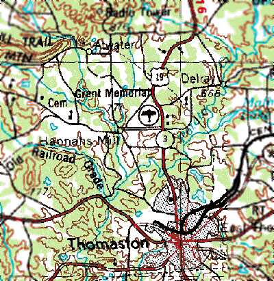
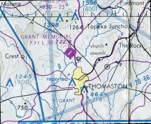
Reginald Grant Memorial Airport, Thomaston, GA
32.94, -84.34 (Southeast of Atlanta, GA)
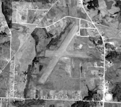
Grant Memorial Airport, as depicted on a 4/4/51 aerial photo (courtesy of David Henderson).
Grant Memorial Airport was evidently established at some point between 1945-51,
as it was not yet listed among active airfields in the 1945 AAF Airfield Directory (courtesy of Scott Murdock).
The earliest depiction which has been located of Grant Memorial Airport was a 4/4/51 aerial photo (courtesy of David Henderson).
It depicted the field as having 2 unpaved runways.
There did not appear to be any airport-related structures.
Grant Memorial Airport evidently gained a paved runway at some point between 1951-68,
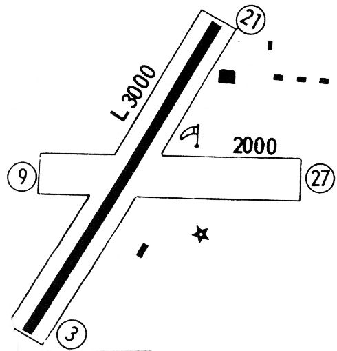
as the 1968 Flight Guide (courtesy of Robert Levittan) depicted the field as having a single 3,000' paved Runway 3/21,
along with an unpaved Runway 9/27.
Six small buildings were depicted on the east side of the field.
Grant Memorial Airport evidently gained a paved runway at some point between 1951-69,
as a 2/26/69 aerial view showed Runway 3/21 had been paved & an 2 small buildings had been added to the southeast of the runway intersection.
Seven single-engine aircraft were visible on the field.
The earliest topo map depiction which has been located of Grant Memorial Airport was on the 1972 USGS topo map.
The earliest aeronautical chart depiction which has been located of Grant Memorial Airport was on the 1978 Atlanta Sectional Chart (courtesy of David Henderson).
It depicted Grant Memorial as having a single paved 3,000' northeast/southwest runway.
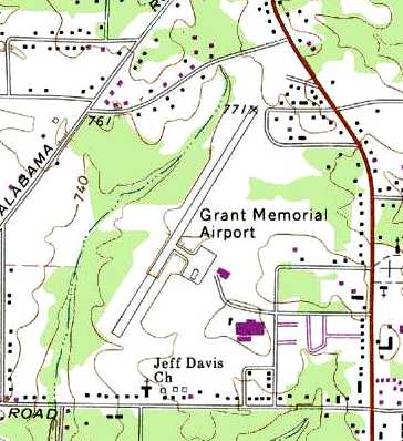
The 1985 USGS topo map (courtesy of David Henderson) depicted Grant Memorial Airport as having a single paved northeast/southwest runway,
with a ramp & 2 small buildings on the southeast side.
The clearing for the crosswind runway was still depicted, but no longer as a runway.
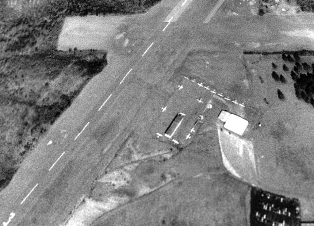
A 1/26/93 aerial view (courtesy of David Henderson) showed Grant Memorial Airport perhaps at its zenith of popularity,
with a total of 18 light aircraft visible on the field.
Taxiways had been constructed & a hangar had been added on the east side of the FBO at some point between 1969-93.
According to David Henderson, “Grant Memorial closed in 1994
shortly after the opening of the newly-constructed Thomaston Upson County Airport several miles to the east.”
According to the Thomaston Airport website, “The existing airport (Reginald Grant Field) had one 2,900' runway,
a circle-to-land NDB approach, 6 T-hangars & 15 based aircraft.”
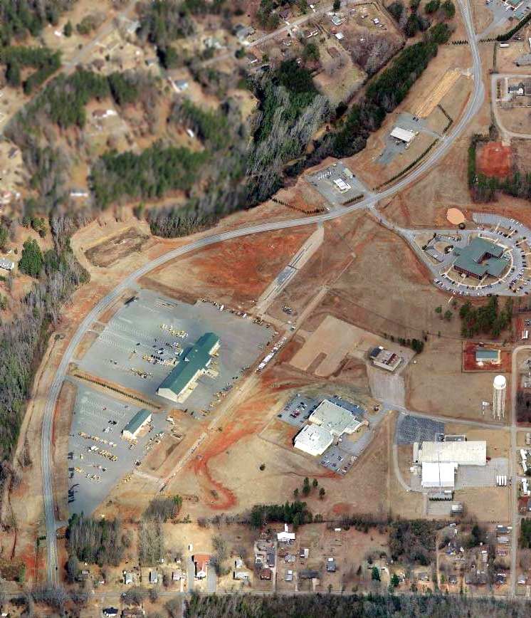
A circa 2011 aerial view looking north (courtesy of David Henderson) of the site of Grant Memorial Airport.
David observed, the photo “shows the old FBO & hangar along with small sections of taxiways & runway still intact.”
A circa 2011 aerial view looking north (courtesy of David Henderson) of the hangar which remains at the site of Grant Memorial Airport.
David Henderson reported in 2013, “Transportation Boulevard winds along the length of the former airport
and the road leading to the old FBO is still named Aviation Drive.
The Georgia DOT occupies most of the buildings on the former airport site.”
The site of Grant Memorial Airport is located at the western terminus of Aviation Drive, appropriately enough.
____________________________________________________
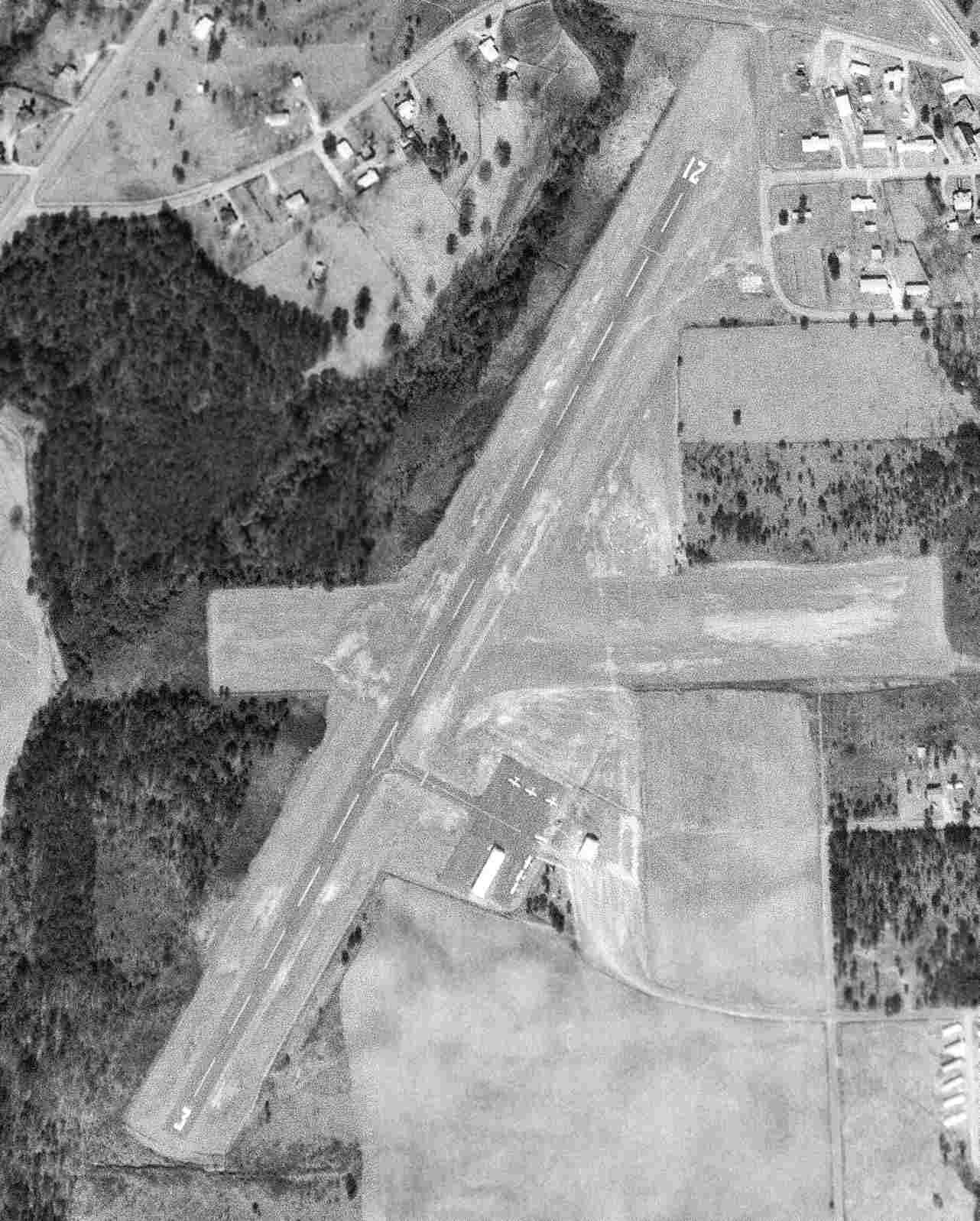
Putnam County Airport (32A), Warfield, GA
33.3, -83.38 (Southeast of Atlanta, GA)
Putnam County Airport, as seen while under construction in a 3/17/71 USGS aerial view.
Putnam County Airport was evidently constructed in 1971, as it was not yet listed in the 1968 Flight Guide (courtesy of Robert Levittan),
and it appeared to have been under construction in a 3/17/71 USGS aerial view.
It depicted land being clearing for a single northwest/southeast runway on the south side of 2 industrial buildings.
Putnam County Airport was not yet depicted on the 1972 USGS topo map.

A 4/29/74 USGS aerial view depicted Putnam County Airport as having a single paved northwest/southeast runway.
Putnam County Airport was not yet depicted on the October 1975 Atlanta Sectional Chart (according to Chris Kennedy).
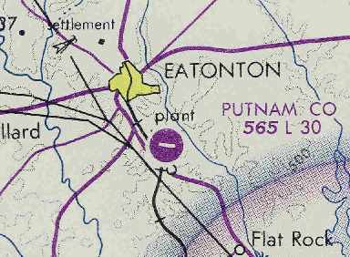
The earliest aeronautical chart depiction of Putnam County Airport which has been located
was on the October 1976 Atlanta Sectional Chart (courtesy of Chris Kennedy).
It depicted Putnam County Airport as having a single 3,000' paved runway.
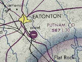
The April 1980 Atlanta Sectional Chart (courtesy of Chris Kennedy)
depicted Putnam County as having a single 3,000' paved runway.
The 1982 AOPA Airport Directory (courtesy of Ed Drury)
described Putnam County Airport as having a single 3,000' asphalt Runway 10/28.
Marion Seckinger recalled, “I'd stop on occasion at the Putnam County Airport just to see what was parked there.
During one visit in the mid to late 1980s, I stopped to talk with a aircraft owner.
He related that he was going to be forced to move to the Baldwin County Airport in the near future.
It seemed that a local businessman, Dudley Horton,
had a mobile-home manufacturing facility adjacent to the airport.
He coveted that wide-open & paved space to park finished mobile homes on.
The story was that he was to purchase & donate a tract so that another airport could be built,
but that has never come to pass.”
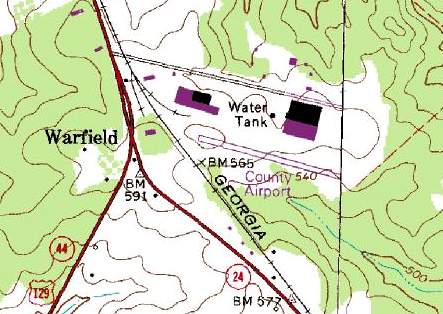
The 1985 USGS topo map depicted the “County Airport” as having a single paved northwest/southeast runway,
with a few buildings to the west & north.
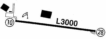
Putnam County Airport was described by the 1986 Flight Guide (according to Chris Kennedy) as being unattended.
The field was depicted as having a single 3,000' paved Runway 10/28.
A ramp was located north of the western end of the runway.
A single small building was located on the north edge of the ramp,
and 2 much larger buildings were located on the northern side of the field.
Putnam County Airport was apparently closed at some point between 1986-93.
According to Brad Turner, “The airfield was closed because Horton Homes
needed room to expand its production & storage of mobile homes & trailers.
A political solution was reached in which the Horton Corporation agreed to hire more locals
if they were permitted to close the airport & use the room for expansion.
Only a few persons, myself included, used the field since the Milledgeville airfield
at the southern end of Lake Sinclair was more populated & built adjacent to the water.
At the time of the closure, the prospect of more local employment
outweighed the needs of only a few local pilots
and a decision was made to close the airfield. I still miss it.”
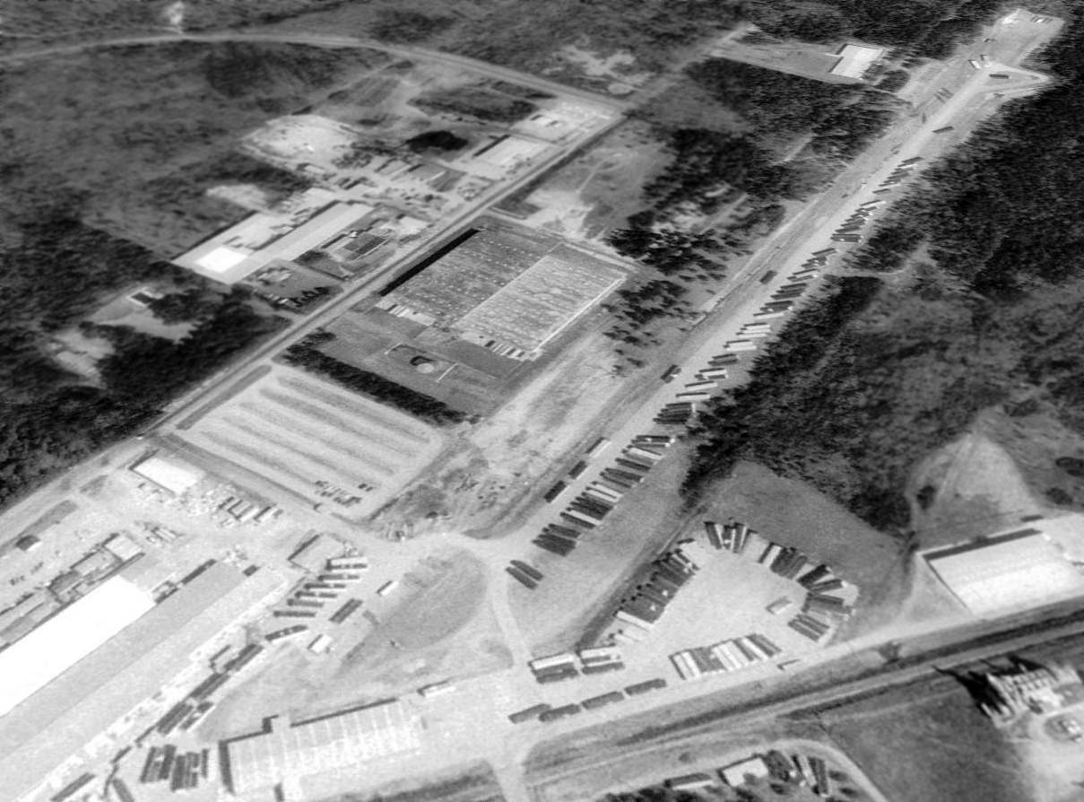
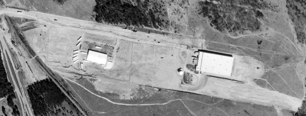
A 1993 USGS aerial view looking northeast at the site of Putnam County Airport showed the runway was still intact, used to store trailers.
It is not apparent if any of the airport buildings remained standing.
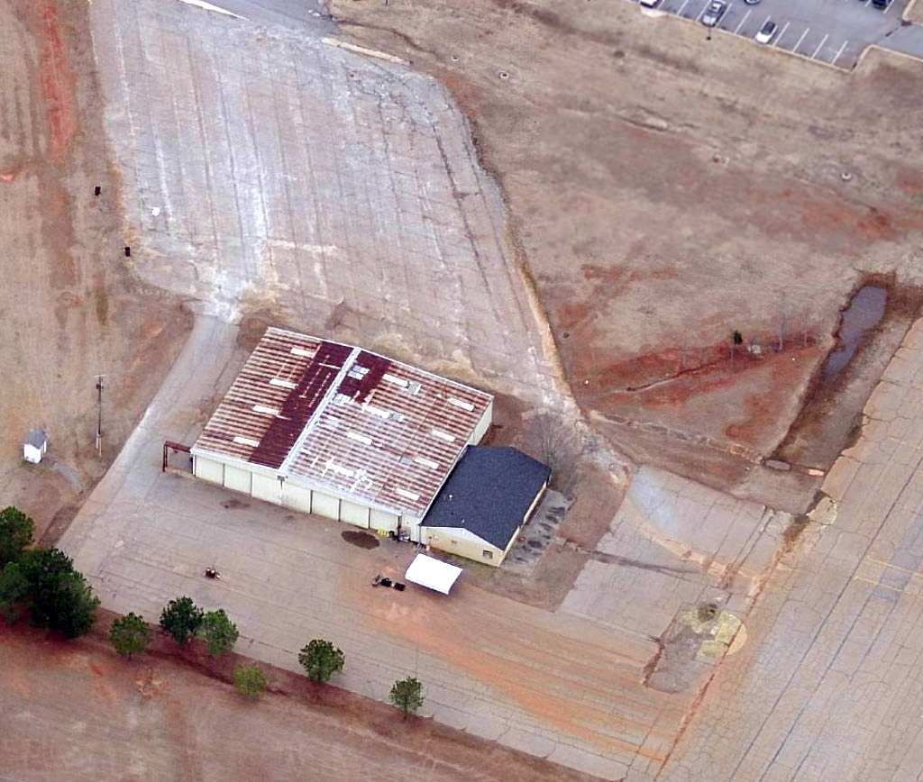
A 1999 aerial photo showed that an industrial building had been built at some point between 1993-99 adjacent to the southeast side of the runway.
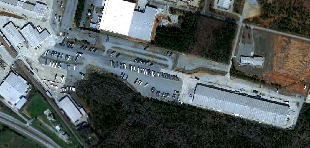
A 1/29/12 aerial photo of the site of Putnam County Airport shows that the majority of the runway pavement remains, but the site is hardly recognizable as a former airport.
The site of Putnam County Airport is located east of the intersection of Routes 441 & 129,
one mile south of Eatonton.
____________________________________________________
Since this site was first put on the web in 1999, its popularity has grown tremendously.
That has caused it to often exceed bandwidth limitations
set by the company which I pay to host it on the web.
If the total quantity of material on this site is to continue to grow,
it will require ever-increasing funding to pay its expenses.
Therefore, I request financial contributions from site visitors,
to help defray the increasing costs of the site
and ensure that it continues to be available & to grow.
What would you pay for a good aviation magazine, or a good aviation book?
Please consider a donation of an equivalent amount, at the least.
This site is not supported by commercial advertising –
it is purely supported by donations.
If you enjoy the site, and would like to make a financial contribution,
you
may use a credit card via
![]() ,
using one of 2 methods:
,
using one of 2 methods:
To make a one-time donation of an amount of your choice:
Or you can sign up for a $10 monthly subscription to help support the site on an ongoing basis:
Or if you prefer to contact me directly concerning a contribution (for a mailing address to send a check),
please contact me at: paulandterryfreeman@gmail.com
If you enjoy this web site, please support it with a financial contribution.
please contact me at: paulandterryfreeman@gmail.com
If you enjoy this web site, please support it with a financial contribution.
____________________________________________________
This site covers airfields in all 50 states.