Abandoned & Little-Known Airfields:
Florida: Southeastern Orlando area
© 2002, © 2016 by Paul Freeman. Revised 9/10/16.
This site covers airfields in all 50 states: Click here for the site's main menu.
____________________________________________________
Please consider a financial contribution to support the continued growth & operation of this site.
Clewiston Airport (revised 8/27/16) - Holopaw Airport (revised 11/8/15) - Malabar NOLF (revised 2/28/16)
Sottile Groves / Canaveral Indian River Groves / Lake Byrd Citrus Packing Company / Cavalier Groves Airfield (revised 9/6/14)
St.
Cloud Airfield
(revised
9/10/16)
____________________________________________________
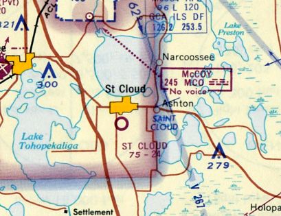
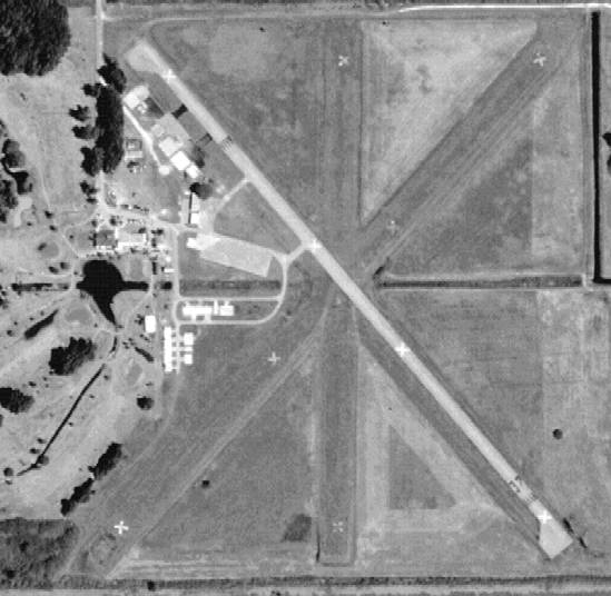
St. Cloud Airfield, St. Cloud, FL
28.234, -81.284 (Southeast of Orlando, FL)
St. Cloud Airfield, as depicted on the November 1965 Orlando Sectional Chart (courtesy of Ron Kunse).
This general aviation airport was evidently established at some point between 1959-65,
as it was not yet depicted on a 1959 aerial photo.
The earliest depiction of the St. Cloud Airfield which has been located was on the November 1965 Orlando Sectional Chart (courtesy of Ron Kunse).
It depicted the St. Cloud Airfield as having a 2,400' unpaved runway.
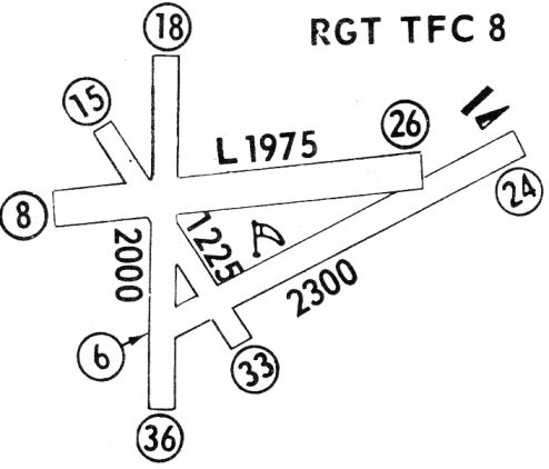
The 1968 Flight Guide (courtesy of Robert Levittan)
depicted the St. Cloud Airfield as having a total of 4 unpaved runways,
with the longest being the 2,300' Runway 6/24, and 1 small building on the northeast side.
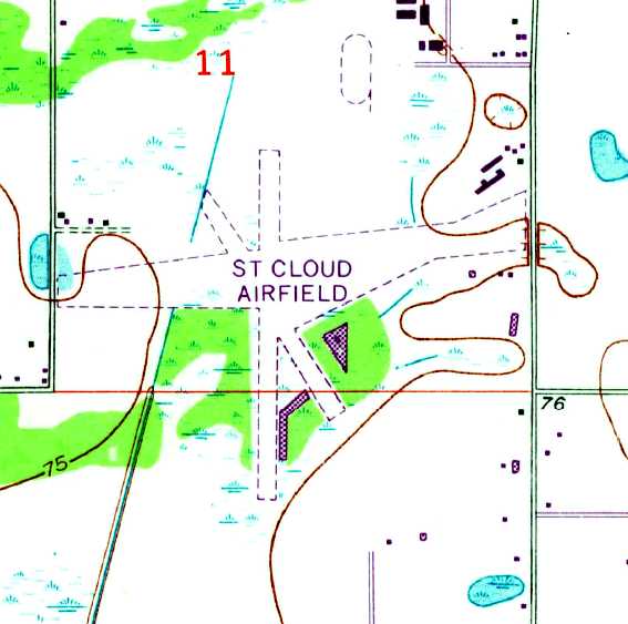
The 1970 USGS topo map depicted the St. Cloud Airfield as having a total of 4 unpaved runways,
with several buildings on the northeast side.
The 1980 USGS topo map continued to depict St. Cloud Airfield in an unchanged fashion.
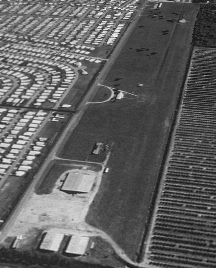
The earliest photo which has been located of the St. Cloud Airfield
was a 1982 aerial view looking northwest by Stephen Mahaley.
It depicted the field as having 4 grass runways, with 2 rows of T-hangars on the northeast side, around which were visible at least 2 light aircraft.

A 1983 aerial view looking southwest at at St. Cloud Airfield depicted several light aircraft parked around the hangars.
A 1994 USGS aerial photo showed that at some point between 1983-94 the St. Cloud Airfield was evidently closed (for reasons unknown),
as the northern row of hangars was completely demolished,
and the southern row of hangars was partially demolished.
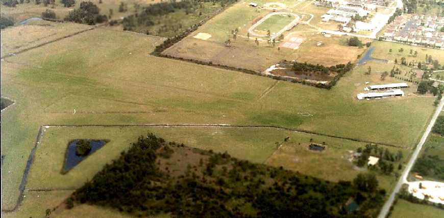
A circa 2005-2010 aerial view looking north depicted the sad sight of the former St. Cloud hangars, fenced off,
with the northern row of hangars having been completely demolished,
and the southern row of hangars having been partially demolished.
A 1/31/08 aerial view depicted the abandoned airfield in a completely unchanged state.
A 5/2/10 aerial view showed that a path to install a gas transmission line had been cut westward through the center of the former St. Cloud Airfield at some point between 2008-2010.
The airfield otherwise remained intact.
The site of St. Cloud Airfield is located southwest of the intersection of Michigan Avenue & Bulldog Lane.
____________________________________________________
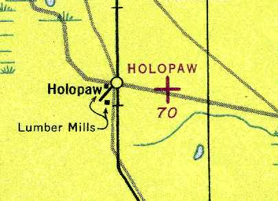
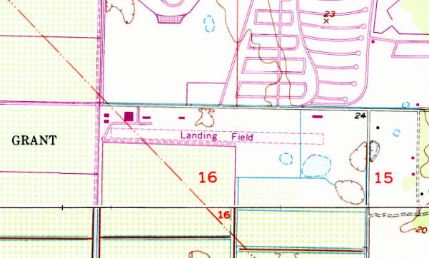
28.138, -81.038 (Southeast of Orlando, FL)
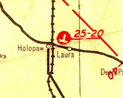
Holopaw Airport, as depicted on the 1936 Official Airway Map of Florida (courtesy of Chris Kennedy).
Photo of the airport while in use has not been located.
This general aviation airport was evidently established at some point between 1934-36,
as it was not yet listed among active airfields in the 1934 Department of Commerce Airport Directory (according to Chris Kennedy).
The earliest depiction of the Holopaw Airport which has been located
was on the 1936 Official Airway Map of Florida (courtesy of Chris Kennedy).
It depicted Holopaw as having 2 runways, oriented east/west & north/south.
The Airport Directory Company's 1938 Airport Directory (courtesy of Chris Kennedy)
described Holopaw as as auxiliary airfield, located 2 miles east of the town of Holopaw.
The field was said to consist of an 80-acre sod field, with 2 runways (3,100' north/south & 2,500' east/west).
The last chart depiction which has been located of Holopaw as an active airfield
was on the July 1943 Orlando Sectional Chart (courtesy of Chris Kennedy).
It depicted Holopaw as an auxiliary airfield.
Holopaw Airport was evidently abandoned (for reasons unknown) at some point between 1943-44,
as it was no longer depicted at all on the February 1944 Orlando Sectional Chart (according to Chris Kennedy).
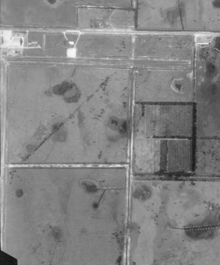
In a 1944 aerial photo of the Holopaw Airport (from the UF Photo Library, via Chris Kennedy),
the field consisted of 2 grass runways, with an airport circle marking in the center.
There did not appear to be any buildings on the field.
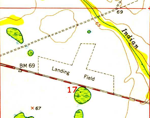
Two runways were still depicted at the site of Holopaw Airport on the 1953 USGS topo map,
but it was labeled merely as “Landing Field”.
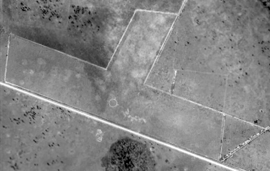
In a 1959 aerial photo of Holopaw Airport, the field was still basically intact (and the airport circle marking was still quite prominent),
but the field had already been closed, and a driveway had been cut across the western end of the east/west runway.
Photo from the UF Photo Library, via Chris Kennedy.
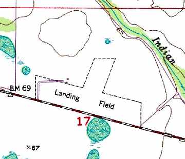
Two runways were still depicted at the site of Holopaw Airport on the 1990 USGS topo map,
but it was labeled merely as “Landing Field”.
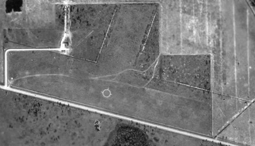
A 1/17/14 aerial view showed the of the 2 former Holopaw runways were still quite recognizable,
although it appears as if trees have filled in the area of the 2 runways.
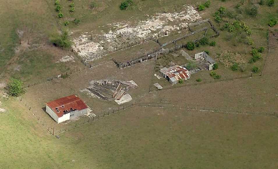
An 11/8/15 photo by Owen Cabo Dal Molin of the site of Holopaw Airport.
Owen reported, “There's still something there. Two small buildings just past the fenced-off gravel road & behind some trees.”
Steven Thorp reported in 2016, “For Holopaw Airport, the now wooded landing field has been designated as a state forest.”
The site of Holopaw Airport is located on the north side of East Irlo Bronson Memorial Highway,
2 miles east of its intersection with Holopaw Road.
____________________________________________________
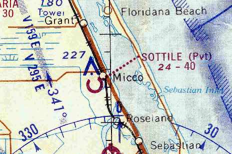
Sottile Groves / Canaveral Indian River Groves /
Lake Byrd Citrus Packing Company / Cavalier Groves Airfield, Micco, FL
27.878, -80.528 (North of Vero Beach, FL)
The airfield on this site has gone through at least 4 different names before being abandoned,
and its origin has not been precisely determined.
This property was reportedly used during WW2 as a glider training facility.
However, no airfield at this location was depicted on Miami Sectional Charts
from 1942, 1943, 1944, 1945, 1947, or 1954 (according to Chris Kennedy),
nor listed among active airfields in the 1944 US Army/Navy Directory of Airfields (courtesy of Ken Mercer).
Aerial photos from 1943 & 1950 (courtesy of Dallam Oliver-Lee) and a 1951 aerial photo (from the University of FL Aerial Photo Library, courtesy of Chris Kennedy)
did not depict any signs of an airfield at this location - just an open grass field.
The earliest depiction which has been located of an airfield on this property
was on a 1958 aerial photo (from the University of FL Aerial Photo Library, courtesy of Chris Kennedy).
It depicted an east/west runway, along with what may have been a north/south runway (along the left edge of the photo).
A ramp was on the north side of the airfield, but no aircraft were visible.
No airfield at this location was listed in the 1962 AOPA Airport Directory.
The earliest reference which has been located to an airfield at this site
was in 1963 AOPA Airport Directory (according to Chris Kennedy).
It described “Sottile Groves” as a private airfield having 2 grass runways: 6,000' Runway 18/36 & 4,000' Runway 9/27.
The listing was based on a "Latest report 1961."
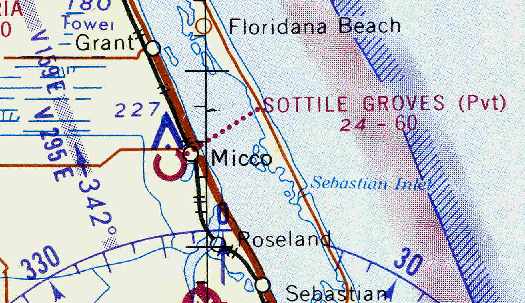
The earliest chart depiction which has been located of an airfield at this site
was on the September 1964 Miami Sectional Chart (courtesy of Chris Kennedy).
It depicted “Sottile Groves” as a private airfield having a 6,000' unpaved runway.
The last chart depiction which has been located of an airfield at this site
was on the March 1966 Miami Sectional Chart (courtesy of Chris Kennedy).
The Aerodromes table on the chart described “Sottile” as a private airfield having a single 4000' turf runway.
At some point between 1966-67 the airfield was evidently renamed “Canaveral Indian River Groves”,
as that is how it was listed in the 1967 AOPA Airport Directory (according to Chris Kennedy).
It was described as having a single 5,000' sod Runway 9/27.
The 1970 USGS topo map depicted a single east/west unpaved “Landing Field” with a few small buildings along the north side.
No airfield at this location was depicted on the 1970 Miami Sectional Chart (or subsequent aeronautical charts).
As a private airfield, the owner had presumably requested that the field not be charted.
At some point between 1967-76 the airfield was evidently renamed again to “Lake Byrd Citrus Packing Company”,
as that is how it was listed in the 1976 Airports USA Directory (according to Chris Kennedy).
It was described as having a single 4,000' turf Runway 9/27.
At some point between 1976-80 the airfield was evidently renamed yet again,
as it was listed as “Cavalier Groves” in the 1980 Airports USA Directory (according to Chris Kennedy).
Its runway configuration was unchanged - a single 4,000' turf Runway 9/27.
The airfield's name & description were unchanged in the 1982 Airports USA Directory (according to Chris Kennedy).
It was depicted as "Landing Field" on the 1985 & 1992 USGS topo maps,
but was not depicted at all (even as an abandoned airfield) on recent aeronautical charts.
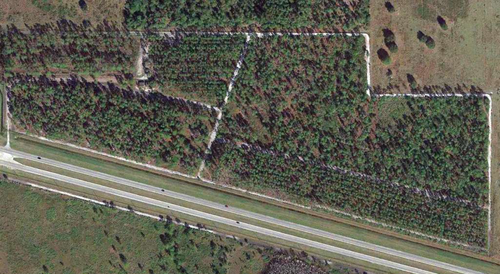
As seen in a 1994 USGS aerial view looking northeast, the airfield consisted of a single east/west 4,100' runway,
and a ramp area north of the west end of the runway with several Quonset huts that were still standing.
There was no clear indication at this point as to whether the airfield was still in operation at this point.
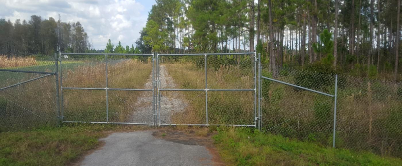
According to longtime area resident Jack Russell, "Sure enough, its still there...
overgrown runway... Quonset huts... large old sheetmetal hangar... still a windsock flying."
Jim Reed reported in 2004, "I just visited the Micco strip which is just up the road from me.
It appears to me that the strip was never paved as I could find no sign of pavement anywhere."

A 4/23/12 aerial view looking northeast showed the Micco airfield to remain intact.
The Micco Airfield is located on the South side of Micco Road, 2 miles west of US Highway 1.
Thanks to Eric Conklin for pointing out this airfield.
____________________________________________________
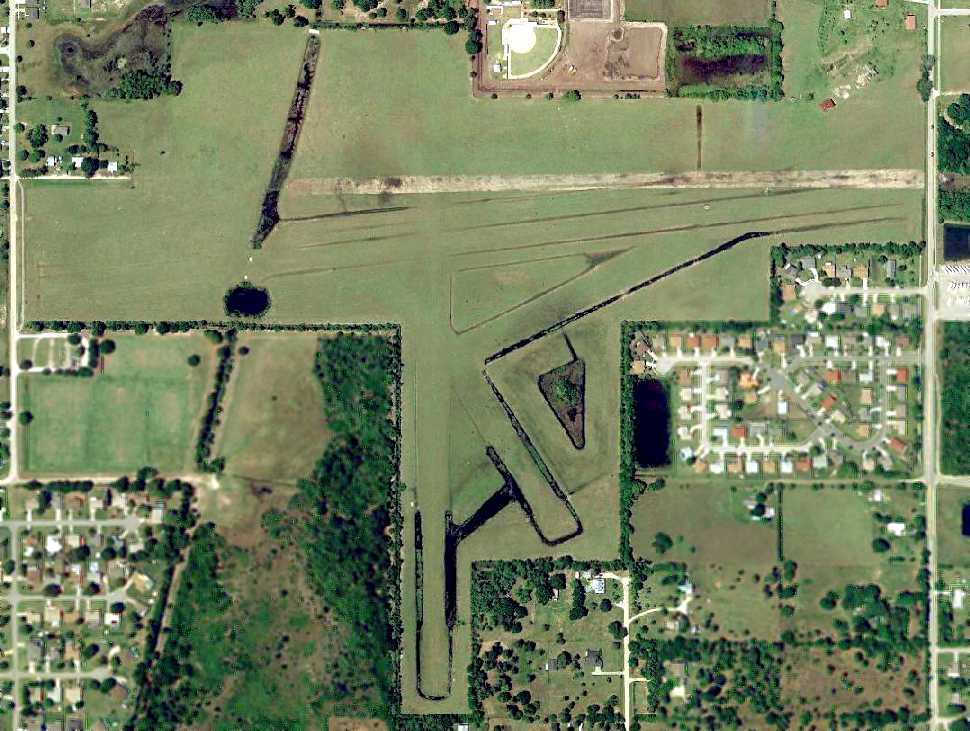
Malabar Naval Outer Landing Field, Malabar, FL
28.02, -80.68 (Southeast of Orlando, FL)
A 1/15/43 aerial view looking northwest showing Malabar OLF under construction (U.S. Navy photo from the National Archives, via Brian Rehwinkel).
This airfield was originally built during WW2 as one of 2 satellite airfields for Melbourne NAS,
which conducted advanced flight training in SNJ Texans, F4F Wildcats & F6F Hellcats.
The Malabar airfield was evidently constructed at some point during 1943,
as it was not yet depicted at all on the January 1943 Miami Sectional Chart (according to Chris Kennedy).
The earliest depiction which has been located of Malabar Field
was a 1/15/43 aerial view looking northwest (U.S. Navy photo from the National Archives, via Brian Rehwinkel), showing Malabar still under construction
Brian Rehwinkle observed, “You can see how isolated the field was in those days.”
Brian Rehwinkel reported, “According to Navy documents, the land (640 acres) was purchased in September 1943
and the Navy spent about $513,000 adding the four 4,000’ x 175' asphalt runways.
One interesting note is that this field (and its sister field Vakaria OLF) were both referred to by the Navy as 'Satellite Fields' rather than Outlying Fields (OLFs).
Although both met the definition of an Outlying Field, the Air Station & Navy decided to use another term.”
A 4/22/43 USDA aerial photo showed Malabar NOLF shortly after its completion
(from the Digital Library Center / University of Florida George A. Smathers Libraries, courtesy of Brian Rehwinkel).
The earliest chart depiction which has been located of the Malabar airfield
was on the July 1943 Orlando Sectional Chart (courtesy of Chris Kennedy),
It depicted “Malabar (Navy)” as an auxiliary airfield.
Malabar was not listed among active airfields in the April 1944 US Army/Navy Directory of Airfields (courtesy of Ken Mercer).
Presumably it was overlooked, as a relatively minor airfield.
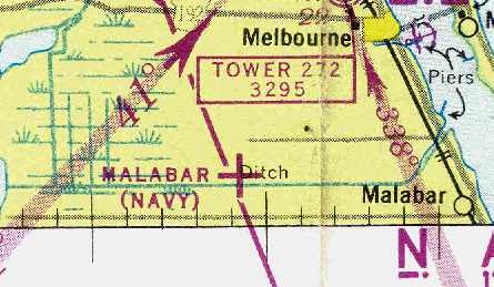
"Malabar (Navy)", as depicted on the 1945 Miami Sectional Chart (courtesy of John Voss).
The last photo which has been located showing Malabar Field still open was a 3/22/45 aerial view (U.S. Navy photo from the National Archives, via Brian Rehwinkel).
It was depicted as an active military airfield, labeled "Malabar (Navy)",
on the 1949 Orlando Sectional Chart (according to Chris Kennedy),
and described as having a 4,000' hard-surface runway.
The 1949 USGS topo map depicted "Malabar Naval Air Station" as having 4 paved runways.
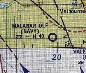
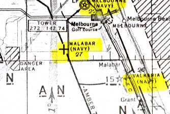
"Malabar OLF (Navy)" was still depicted as an active airfield on the August 1954 Orlando Sectional Chart (courtesy of Chris Kennedy),
but the Aerodromes table on the chart listed its status as "Closed, leased for grazing."
The Malabar airfield was no longer depicted at all on the August 1957 Miami Sectional Chart (according to Chris Kennedy).
The property was labeled "Malabar Annex (USAF)" on a 1972 USGS topo map.
It was depicted as an abandoned airfield on the 1978 Miami Sectional Chart (courtesy of Ed Drury).
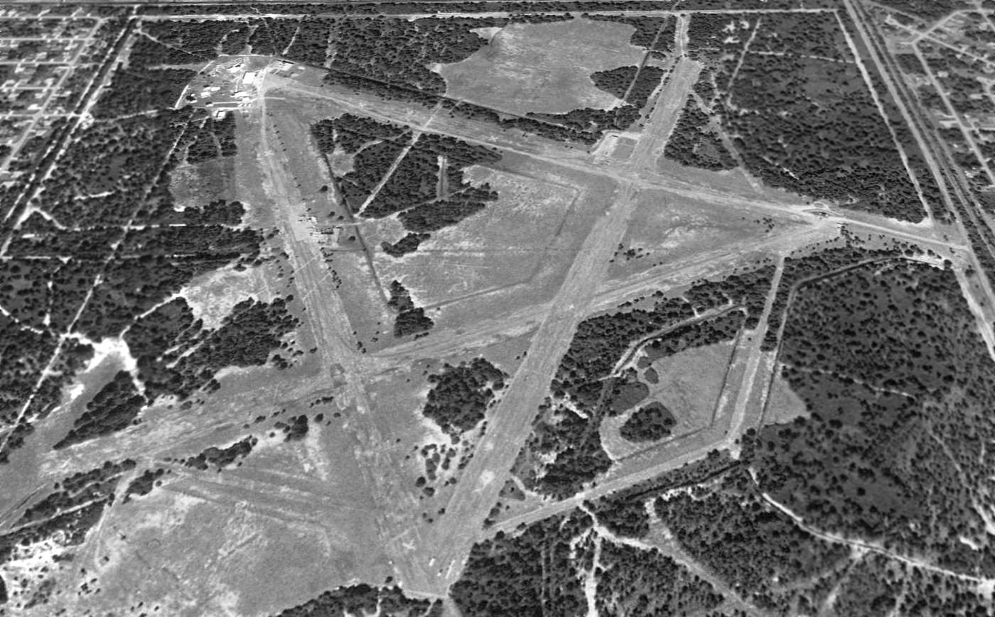
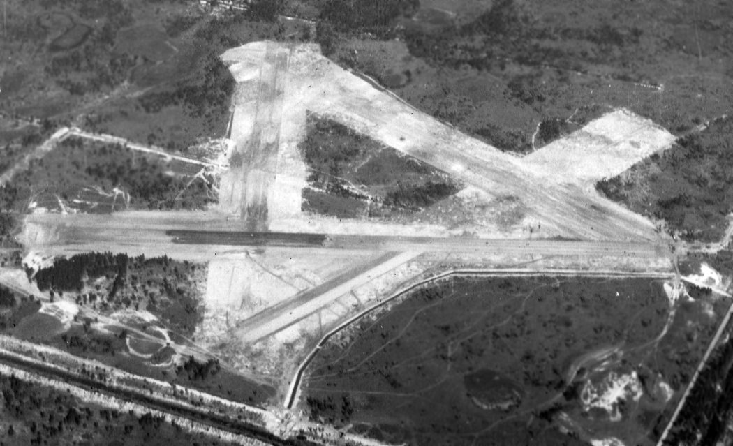
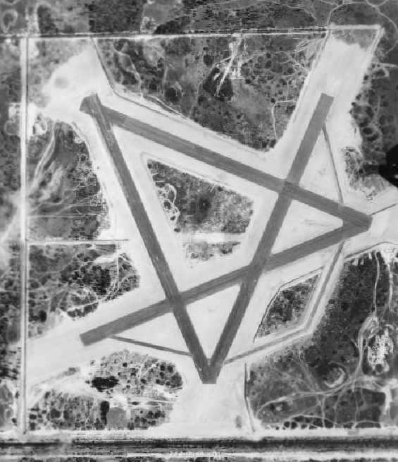
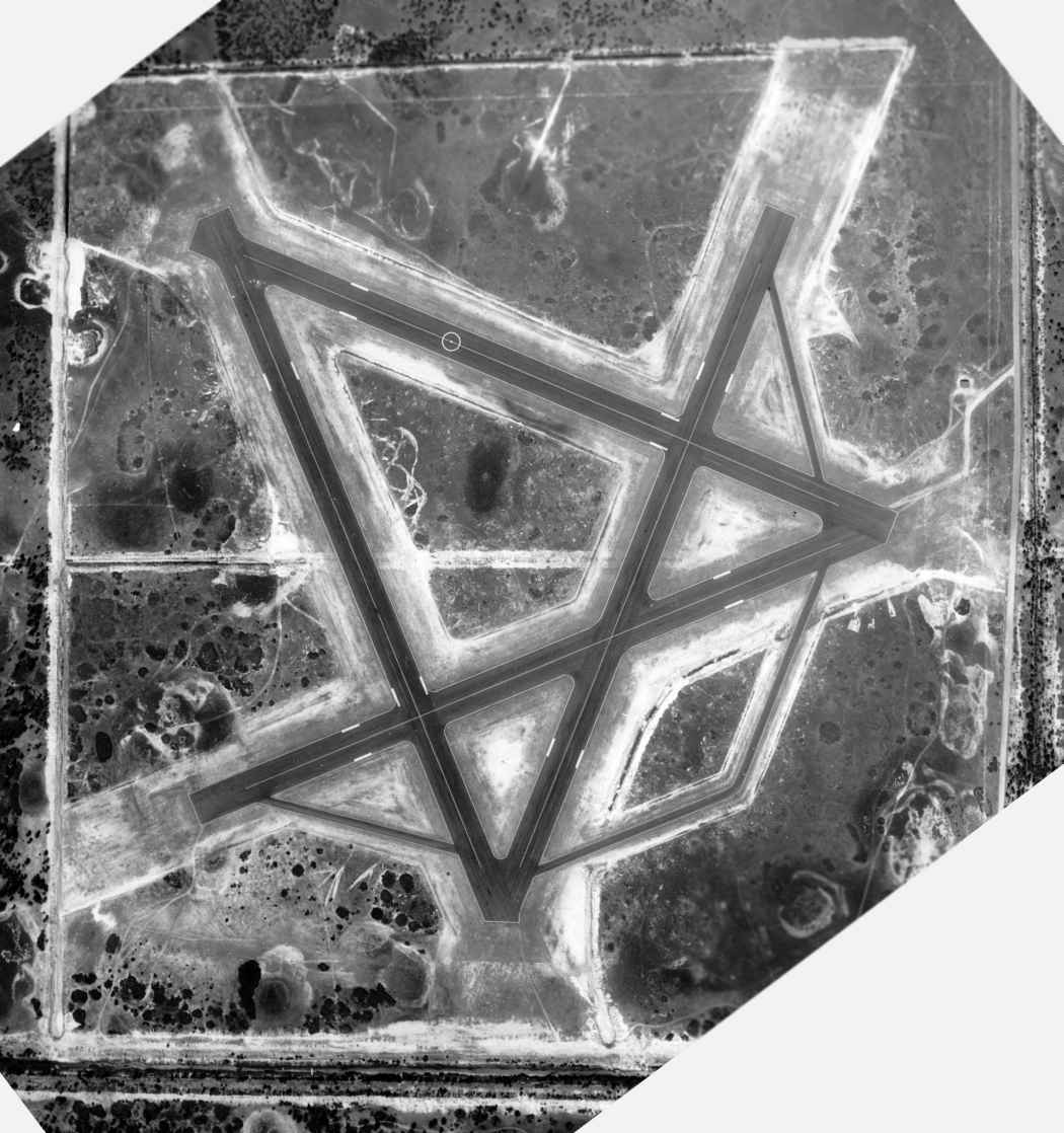
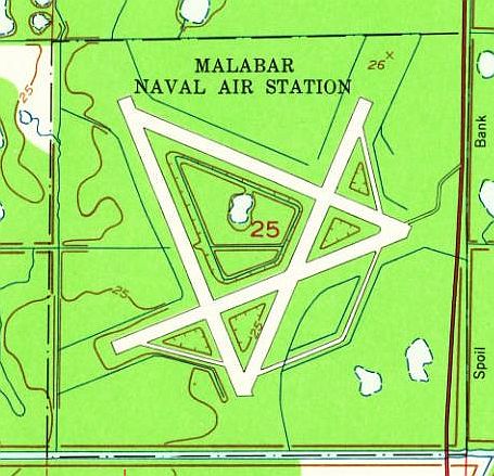
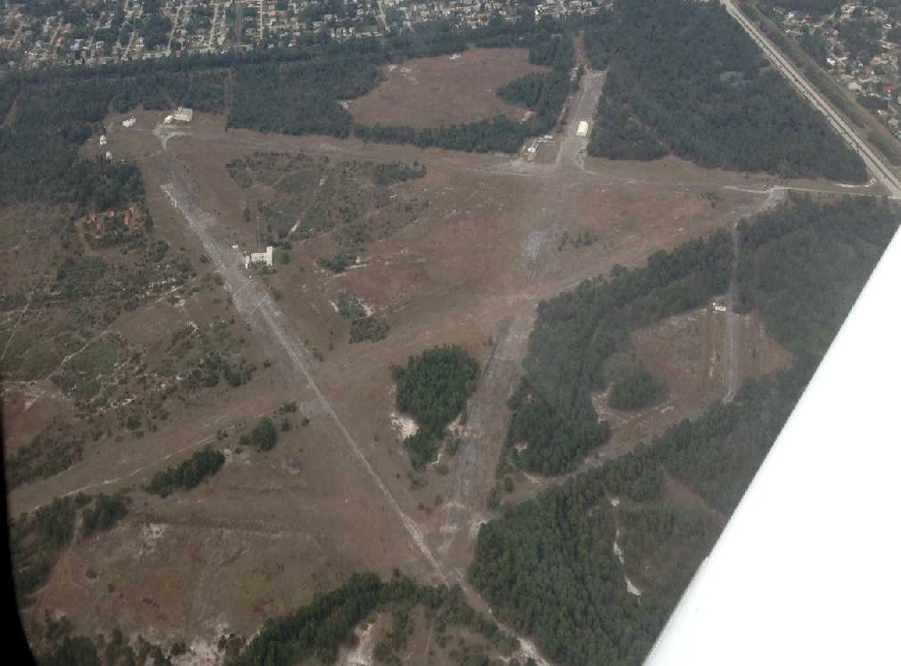
A 1994 USGS aerial view looking north showed the Malabar airfield to consist of 4 paved 4,100' long runways, arranged in a star pattern, along with taxiways & ramp areas.
The runways were in varying states of decay.
The NE/SW runway appeared to be in the best condition, while closed runway "X" markings still visible on the NW/SE runway.
The former Malabar airfield property was labeled "Lynbrook Park" on a recent street map.
It is located within a city block, now surrounded by development.
According to Eric Conklin, the Malabar property is still actively being used by the Air Force.
It is now called "Malabar Transmitter Annex".
There are almost a dozen antenna towers at different locations around the facility, log periodics, etc.,
and the primary function is a remote transmitter site to support operations
for Kennedy Space Center / Cape Canaveral AFS.
This facility is under very tight security.
There is an annual "shoot 'em-up" drill held at this facility to drill for penetration incidents.
The neighbors (it's located right in the middle of the City of Palm Bay) always dial 911 to report explosions
when the Air Force does their penetration drills there.
The facility is under the control of the 45th Space Wing & security is administered (offices) from Patrick AFB.
Malabar was still depicted as an abandoned airfield on recent aeronautical charts.
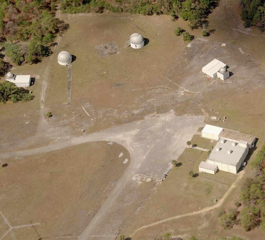
A circa 2006-2007 aerial view looking west at the northwest end of the former Malabar runways,
showing several telescope domes.
As of 2007 the property was labeled on street maps as the “U.S. Air Force Malabar Annex”.
An April 2013 aerial view by James Wright looking north at the former Malabar runways.
Thanks to Matt Westbrook for information about Malabar.
____________________________________________________
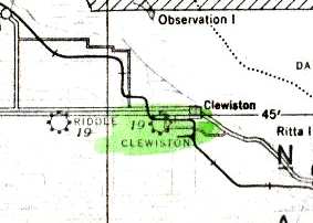
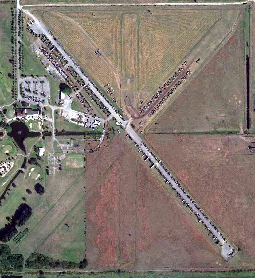
Clewiston Airport, Clewiston, FL
26.743, -80.948 (West of West Palm Beach, FL)
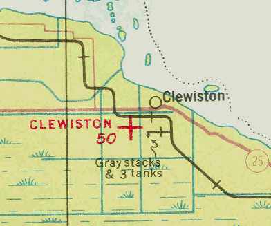
Clewiston was depicted as an auxiliary airfield on the December 1935 Miami Sectional Chart (courtesy of Chris Kennedy).
The date of construction of Clewiston Airport has not been determined.
The earliest reference to the field which has been located
was in the 1934 Department of Commerce Airport Directory (according to Chris Kennedy).
It described Clewiston Airport as being located 1.5 miles southwest of the town of Clewiston.
The field was said to be cross-shaped, with 2 sod runways, the longest being the 2,400' north/south strip.
The earliest depiction of Clewiston Airport which has been located
was on the December 1935 Miami Sectional Chart (courtesy of Chris Kennedy).
It depicted Clewiston as an auxiliary airfield.
The November 1936 "Official Airway Map of FL" (courtesy of Chris Kennedy)
depicted Clewiston as having a single north/south runway.
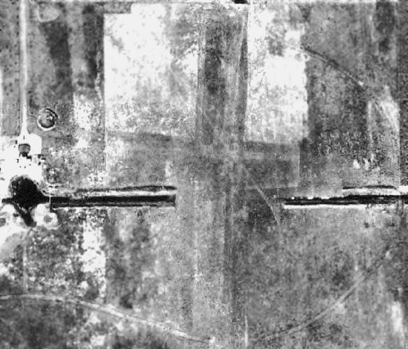
A 12/10/38 USDA aerial photo of Clewiston Airport,
from the Digital Library Center / University of Florida George A. Smathers Libraries (courtesy of Brian Rehwinkel).
Clewiston was depicted as having 2 grass runways (oriented north/south & east/west),
with a drainage ditch crossing over the middle of the field.
A single small building (a shed?) appeared to be on the west side of the field.
During WW2, Clewiston was used as a satellite field for nearby Riddle Field (later reused as Airglades Airport),
which operated a contract flying school used by the AAF during WW2 to train both US & British military pilots.
The 1944 US Army/Navy Directory of Airfields (courtesy of Ken Mercer) described Clewiston Airport as having a 3,000' runway.
Clewiston was depicted as a commercial or municipal airport
on the 1945 Miami Sectional Chart (courtesy of John Voss).
Clewiston Airport, as depicted in a 12/31/48 US Government aerial photo (courtesy of the FL DOT).
Clewiston was depicted as having 3 turf runways.
There did not appear to be any hangars on the field, just some small sheds on the western side of the property.
A total of a dozen light aircraft were visible on the field.
According to former nearby resident Dennis Anderson,
Clewiston Airport was used after WW2 to operate business aircraft by US Sugar.
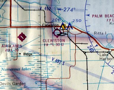
Clewiston was depicted on the March 1966 Miami Sectional Chart (courtesy of Ron Kunse) as having a 3,000' unpaved runway.
The 1971 Flight Guide (according to Chris Kennedy) depicted Clewiston as having 3 turf runways.
Suzanne Harper recalled, "I went to my first Fly-In back in 1972 at the Clewiston Airport.
We fell in love with the Airport & dreamed that someday we would move to Clewiston & operate the airport."
Clewiston was still depicted as an active airport on the 1978 Miami Sectional Chart (courtesy of Ed Drury).
It had apparently gained a paved runway,
as the chart depicted the field as having a single 3,000' paved runway, oriented northwest/southeast.
Tracie Schneider recalled, “My memories of the Clewiston Airport in 1978-80...
During that period an older man named Frank Belk managed the Clewiston Airport,
and we would often stop there when we were flying in the area & visit with him.
I remember there being 2 unpaved grass strips at the field, but don’t recall there being a paved one.
Frank & his wife lived in a small house by the end of one of the runways & would host pot luck fly-in gatherings at the airport on Sunday afternoons.
Folks from all over would fly in with their casseroles.
Frank’s wife would add her cakes & pies & we’d set it all out on long folding tables where we’d sit around & eat & swap flying stories.
One of the 'regulars' who’d show up was Jerrie Cobb, who was flying missions to the Amazon at that time.
I recall that Frank had accompanied her on one of her flights & he regaled us all with stories of his adventures there.
That day Jerrie gave several of us, including myself, a short ride around the area in her airplane & it was thrilling, to say to least, to be flying with a living legend.”
Tracie continued, “On days when the pot-luck fly-in wasn’t happening, we’d borrow Frank’s old truck that he kept at the airport for pilots to use,
and drive into the town of Clewiston to eat at the Old South BBQ Ranch.
Mr. Belk had an old hangar or barn building that was filled to the brim with old airplane parts.
I recall that he had built a Piper Cub that he let us take up for a flight.”
Suzanne Harper recalled, "In April of 1982 during my volunteer work with the South Dade Country Fair,
I had the opportunity to meet the City Commissioners from Clewiston.
They asked us if we would be interested in managing the little Clewiston Airport
(now that was a silly question, since it would fulfill a dream that we always had).
In November of 1982 I received a call from one of the commissioners
asking if we were interested in the management of the Clewiston Airport.
When we arrived, I could not find the commissioner I had talked to.
My Dad looked at the Airport and stated, 'you don't really want to do this.'
The Airport was very run down. So we left & didn't think anymore about it."
Suzanne continued, "On 1/17/83 I packed my bags & moved to the Clewiston Airport.
We lived under the big tree with the rats, spiders & snakes
in a travel trailer that I borrowed from my Mom & Dad.
I began to clean & rebuild. I even painted the hangar & remodeled the office myself.
The local pilots came by everyday & offered to help & told me stories about the town.
By April we were ready for our first Fly-In, the 'Cane Raisin' Flyin'. It was a big success."
Richard Wheeler recalled of Clewiston, "I flew in there a few times in 1990.
I was working for a helicopter school in Fort Lauderdale,
and one of the designated examiners we used flew for US Sugar out of this field.
The owner of the school had a really nice Cessna 152 Aerobat,
and normally we wouldn't be allowed to fly it.
But we were tight on getting checkrides done so on occasion I,
being the only other fixed wing rated pilot besides the owner,
would get to fly over to Clewiston to pick the DE up & take him back to FXE to conduct some checkrides,
and then fly him back to Clewiston.
I also flew a helicopter & a student for a checkride up to there once."
Richard continued, "Of what I remember of the field in 1990 was that in was immaculately maintained.
The paved runway was in excellent condition,
and the turf runways were also very nice, and quite well manicured.
US Sugar ran their King Air & their Bell 206 out of there,
and I heard rumors that they also flew their Citation (1 or 2) out of there as well,
but I wasn't personally witness to that.
I seem to recall other, non-US Sugar aircraft based there as well."
Suzanne Harper recalled, "We had a contract with the City to manage the Airport.
We had asked for 20 years & it was discussed that the airport would probably close in 20 years.
To our dismay US Sugar asked to close the airport after only 11 years [in 1994].
This was so that they could move their aircraft to the Airglades Airport
and get the grant funding for improvements needed.
Needless to say everyone on the Airport was very upset by this.
I fought the closure of the Clewiston Airport.
Even though we served the Community faithfully & respectfully for 11 years at no expense to the taxpayers,
we were given 6 months to move our business of 11 years.
We didn't want to move from Hendry County
but there were no facilities available at the Airglades Airport for an Aircraft Service Center.
So determined not to let our customers down we relocated in August 1994 to the Pahokee Airport."
Richard Wheeler recalled, "I remember I was surprised when the field closed,
because it was in such great shape the last time I was there."
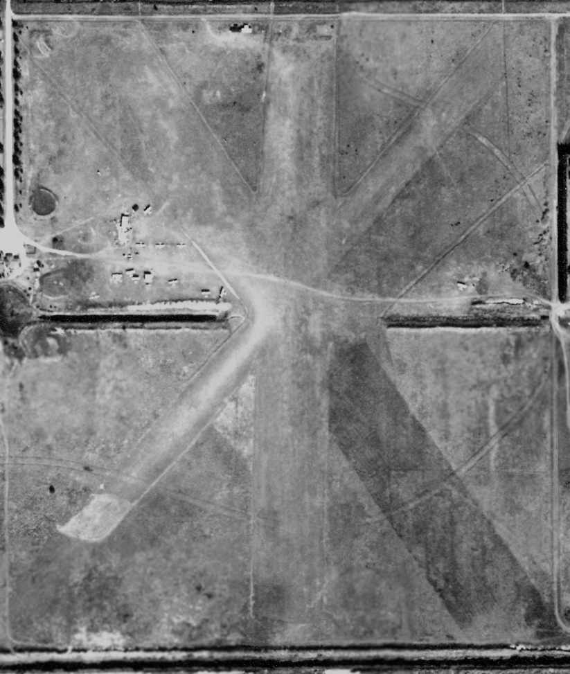
As seen in the 1996 USGS aerial photo, the most recently used runway, 4/32, is 3,000' long.
The remains of 2 other runways still existed, along with taxiways, ramps & hangars.
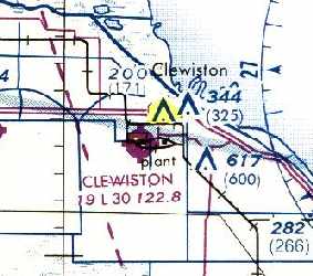
Clewiston was still depicted as an abandoned airfield on the 1998 World Aeronautical Chart.
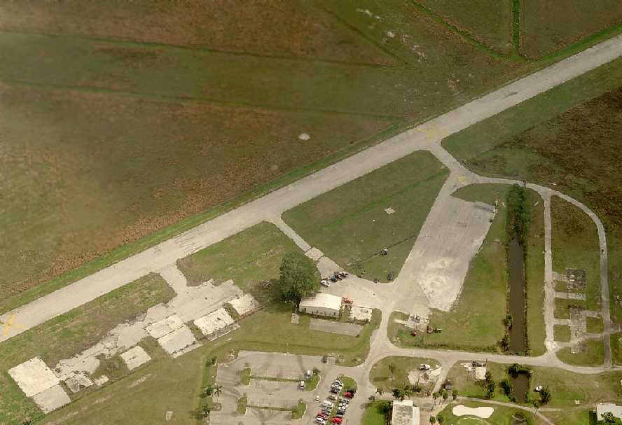
A circa 2006 aerial view looking east at the site of Clewiston Airport
showed that all of the hangars except for one had been removed,
but all of the pavement of the runway, taxiways, and ramps remained intact.
Lou Thole visited the site of Clewiston Airport in 2008,
and reported that “the runway was littered with farm implements, mostly tractors,
that had just been auctioned & were waiting to be picked up.”
A 2/17/14 aerial view showed farm implements covering Clewiston Airport's paved runway.
____________________________________________________
Since this site was first put on the web in 1999, its popularity has grown tremendously.
That has caused it to often exceed bandwidth limitations
set by the company which I pay to host it on the web.
If the total quantity of material on this site is to continue to grow,
it will require ever-increasing funding to pay its expenses.
Therefore, I request financial contributions from site visitors,
to help defray the increasing costs of the site
and ensure that it continues to be available & to grow.
What would you pay for a good aviation magazine, or a good aviation book?
Please consider a donation of an equivalent amount, at the least.
This site is not supported by commercial advertising –
it is purely supported by donations.
If you enjoy the site, and would like to make a financial contribution,
you
may use a credit card via
![]() ,
using one of 2 methods:
,
using one of 2 methods:
To make a one-time donation of an amount of your choice:
Or you can sign up for a $10 monthly subscription to help support the site on an ongoing basis:
Or if you prefer to contact me directly concerning a contribution (for a mailing address to send a check),
please contact me at: paulandterryfreeman@gmail.com
If you enjoy this web site, please support it with a financial contribution.
please contact me at: paulandterryfreeman@gmail.com
If you enjoy this web site, please support it with a financial contribution.
____________________________________________________
This site covers airfields in all 50 states.