
Abandoned & Little-Known Airfields:
California: Central Riverside County
© 2002, © 2016 by Paul Freeman. Revised 10/21/16.
This site covers airfields in all 50 states: Click here for the site's main menu.
____________________________________________________
Please consider a financial contribution to support the continued growth & operation of this site.
Desert Air Airport / Palm Desert Airpark (revised 8/30/16) - Indio Airport (added 4/24/14)
North Shore Airport (revised 12/23/14) - (Original) Palm Springs Municipal Airport / Stevens Airport (revised 10/21/16)
____________________________________________________
33.73, -116.21 (East of Los Angeles, CA)

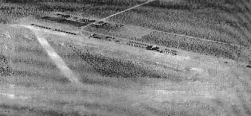
A 1949 aerial view of Indio Airport (courtesy of Mike Butvidas).
According to Joe Schneider, “The [Indio] Airport was the first to bring mail by air to Indio in the 1930s
and was located where Jackson & Varner Road is today.”
Indio Airport was not depicted on the 1945 San Diego Sectional Chart (courtesy of John Voss).
Mike Butvidas recalled, “Indio Airport was located at the southeast corner of Jackson Street & Avenue 44;
my mother worked there circa 1947.
That is where my Mother took lessons, obtained her license & met my father who was taking flying lessons on his VA bill.
My Mother had a picture of Jacque Cochran's Lodestar parked at the Indio Airport
and I think some pictures of an AT-6 that was being ferried or belonged to the WASPs.
I believe the airport was owned or operated by a Dr. Gene Morris; I knew him as a kid & he was a great guy.
The story goes that he bought a P-38 after the war despite the fact he had never flown a twin or retractable gear airplane.
I was told he could not initially get the gear down & the airport had to call somebody in town that had flown one during the war to help help walk him through the problem.
I heard he sold it because of coolant leaks.”
The ownership of Indio Airport by Gene Morris was confirmed by a 3/1/46 Desert Sun article (courtesy of Mike Butvidas).
The earliest depiction which has been located of Indio Airport was a 1949 aerial view (courtesy of Mike Butvidas).
It depicted Indio Airport as having a single unpaved northwest/southeast runway, with several light planes on the west side.

The last photo which has been located of Indio Airport was a 5/2/53 USGS aerial view.
The number of aircraft visible on the field had decreased from the 1949 photo to only two.
According to Joe Schneider, the Indio Airport operated “up to around the 1950s.”
Indio Airport was not depicted on the 1956 USGS topo map
nor on the August 1965 San Diego Sectional Chart (courtesy of Ron Kunse).
A 1996 USGS aerial view showed no trace remaining of Indio Airport, with the site covered by houses.
An 11/26/12 aerial photo showed no trace remaining of Indio Airport.
Mike Butvidas reported in 2014, “The site is now predominantly housing & some retail stores.”
Thanks to Mike Butvidas for pointing out this airport.
____________________________________________________
Desert Air Airport / Palm Desert Airpark, Rancho Mirage, CA
33.74, -116.4 (East of Los Angeles, CA)

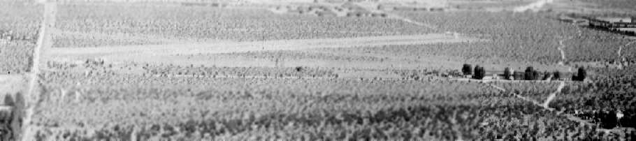
An undated aerial view looking north at Palm Desert Airpark from the 1950 Air Photo Guide (courtesy of Kevin Walsh).
According to Barry Schiff's column “Those Good Old Days” in the April 2014 issue of AOPA Pilot,
“During the years following World War II, there were numerous airports that were destinations unto themselves,
places developed for the sole purpose of enticing wandering aviators to drop in from the sky.
One such place & my all-time favorite was Palm Desert Airpark.
In 1946 Los Angeles architect Hank Gogerty purchased a few hundred acres of desert about 10 miles southeast of Palm Springs.
There he sculpted & groomed a pair of beautifully manicured grass runways shaped like a pair of emerald scissors.
The longest was 3,000' & occasionally used for polo.
Overnight accommodations at the airpark initially consisted of war-surplus barracks that Gogerty had trucked in from Beaumont, 40 miles to the west.”
The earliest depiction which has been located of Palm Desert Airpark
was an undated aerial view looking north from the 1950 Air Photo Guide (courtesy of Kevin Walsh).
The guide described Palm Desert Airpark as having a 3,000' grass runway,
and listed the manager as William Brown.
According to Barry Schiff's column “Those Good Old Days” in the April 2014 issue of AOPA Pilot,
“In 1951 he heralded the opening of his Desert Air Hotel, a true oasis complete with individual cottages, a pool,
a dining room, and a fabulous watering hole that attracted pilots from near & far.
During its heyday, there could be as many as a 100 visiting airplanes parked at Palm Desert on holiday weekends.
Many belonged to Hollywood celebrities, politicians, royalty, and other notables seeking escape.”
According to www.travelgolf.com, "There was an old cottage on the property was converted into a dining room in the late 1940s.
The Compass Room Bar with an adjacent swimming pool was built in 1950
and the Desert Air Hotel was opened in 1951 on this site.
Eventually the airstrip was named Palm Desert Air Park
and many Hollywood celebrities & other well-known persons
including senators & President Eisenhower winged in here in their own aircraft.
An early-day TV sitcom, 'The Bob Cummings Show' was filmed in part at the resort,
and a press preview of the show was held at the hotel.”
According to a 4/6/60 L.A. Times article,
"Henry L. Gogerty designed & operated the Desert Air Hotel & Palm Desert Airpark."

An undated (circa 1950s?) aerial view of dozens of light planes parked next to the hotel at the Palm Desert Airpark (courtesy of Jonathan Westerling).

An undated (circa 1950s?) aerial view of aircraft (including 2 twins) parked next to the hotel at the Palm Desert Airpark (courtesy of Jonathan Westerling).
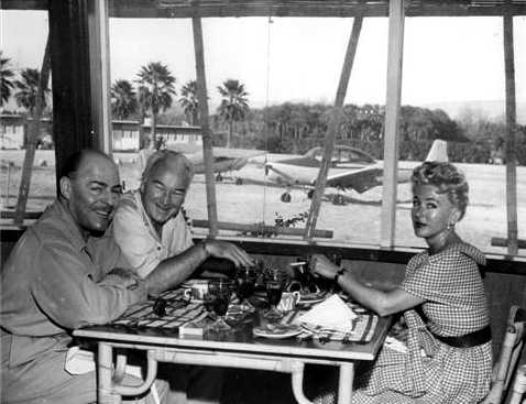
An undated (circa 1950s?) photo of diners in the Palm Desert Airpark restaurant (courtesy of Jonathan Westerling).
According to Kim Houskin, the diners are Brian Donlevy, and William & Grace Boyd.
According to Kim Houskin “Celebrities & regular folk alike would eat at Desert Air.
It was a fly-in resort, complete with pool, rental units etc. They even had a cross runway, a portion of which was used to play polo on.
Edgar Bergen would fly in here in his plane. When President Eisenhower retired to the desert he used the airport.”
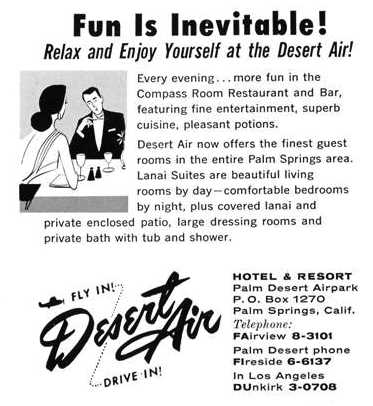
An undated (circa 1950s?) advertisement for the Palm Desert Airpark Hotel & Resort (courtesy of Jonathan Westerling).
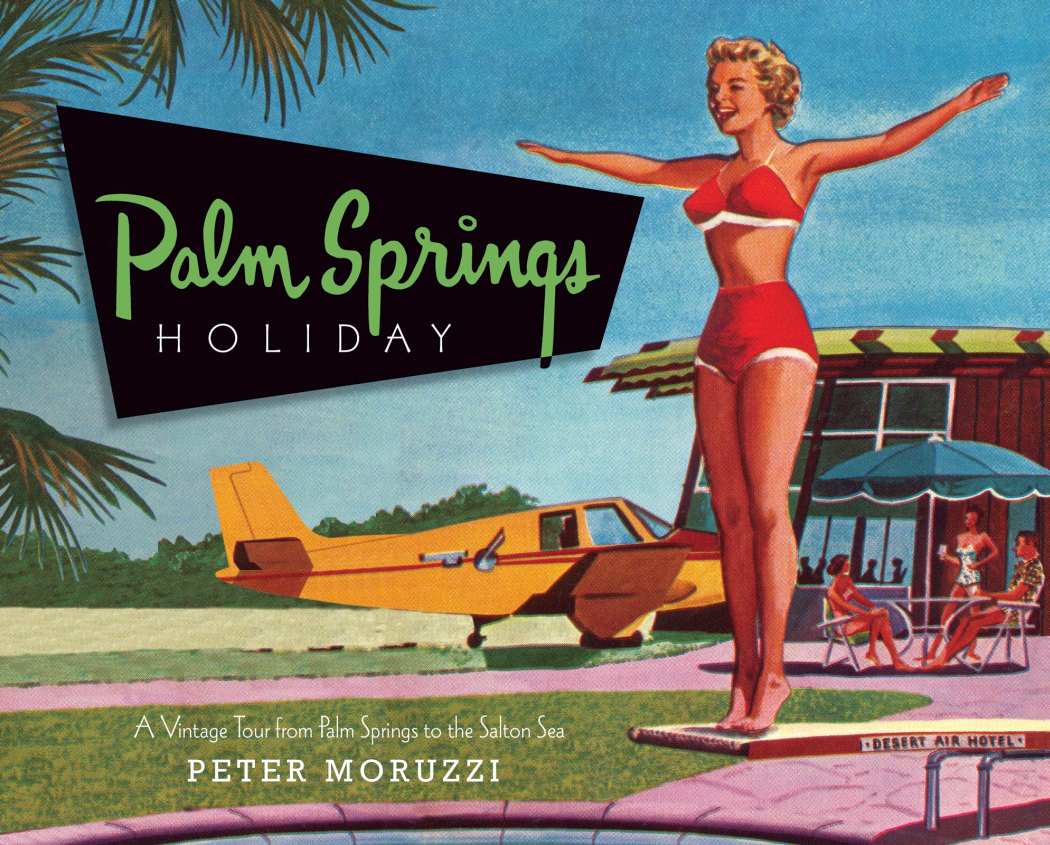
An undated (circa 1950s?) advertisement for the Palm Desert Air Hotel from the cover of Peter Morruzzi's 2009 book, “Palm Springs Holiday” (courtesy of Barry Schiff).
According to Barry Schiff's column “Those Good Old Days” in the April 2014 issue of AOPA Pilot,
“My first of many flights to Palm Desert occurred when I was a 20-year-old college student.
My date & I flew there from Santa Monica in a rented Cessna 140, one in which I also worked as a part-time flight instructor.
I parked our airplane next to the North American Navion owned by famed entertainer & ventriloquist, Edgar Bergen.
His dummy, Charlie McCarthy, sat motionless in the right seat, as if guarding the aircraft.
I have always regretted not having taken a photograph (on film!) of that delightful sight.
We stepped out of the taildragger & onto the cool grass in our bare feet, wearing bathing suits, sunglasses, and baseball caps.
There were no gates, fences, or other security measures.
We strolled 100 feet to our reserved poolside table where cold drinks & hors d’oeuvres were already waiting.”
Barry continued, “At certain times of the year, large clusters of dates fell from palm trees on the far side of the runways.
Visitors were encouraged to take home all they could pick up & carry.
They also were cautioned not to overload their aircraft on hot days.”
According to Richard Arabian, “The facility was located north of Highway 111.
As a youngster I received my 3rd airplane ride there around 1955-56 in a Cessna 195, a memorable experience.
The Desert Air Resort was the main facility on the field & quite a facility it was for the time with an large pool (possibly Olympic size),
three diving boards up to 30', a large ranch-style hotel with restaurant & bar. I understand the adult socializing was quite colorful at times.
The airfield itself was sod with 2 crossing runways, the longest of which was probably 3,000'.
A number of notables frequented the facility, including Hollywood types (Bob Cummings, Robert Taylor & a few other real pilots from WWII)
who had aircraft & flew into either the resort itself or adjacent private residences.”
Henry Meyer recalled, “Palm Desert Airport... Located on the North side of 111, it coexisted with a restaurant, and was a grass strip.
No radio. I landed there in our Apache hauling carpenters to a condominium site in Palm Desert.”
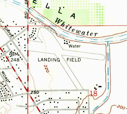
The 1957 USGS topo map depicted the Palm Desert Airpark as 2 runways labeled simply as “Landing Field”.

A circa 1958-59 photo of the Palm Desert Airpark restaurant (courtesy of Cameron Shepherd).
A 1963 FAA Airmen's Guide (courtesy of Jonathan Westerling) described Palm Desert Airpark as having a 3,000' unpaved runway.
According to Joe De Nunzio, the 1963 San Diego Sectional described Palm Desert as a public-use airport with a 3,000' unpaved runway.
Jack Silva recalled, “Palm Desert... had a golf course & a restaurant right next to the strip that I used to go to for breakfast.
It was a great place to fly in to. The strip was manicured grass.
Lots of celebrities flew into that strip. One of the frequent visitors was Bob Cummings in his Twin Beech.”
John Miller recalled, “I used to fly into Palm Desert Airport in the 1960s.
It was located between Bermuda Dunes & Palm Springs Airports.
They had a grass strip & there was a restaurant & motel there.
I used to fly in there in a Cessna 182 when the winter weather had settled in around SNA.
Often times the sprinklers were running & sometimes we'd get a plane wash during touchdown on the grass.
There was a dry wash or river bed at the south end of the runway.
When we taxied up to the restaurant they would put down a red carpet for us to exit on.
Similar to the way Las Vegas would do for small aircraft before it became so huge.
Palm Desert Airport had a swimming pool, restaurant & little motel units placed between grapefruit trees.
There was a scene in Mad, Mad, Mad World where some people pursuing a treasure asked drunken actor Jim Bacus to fly them in an old biplane.”

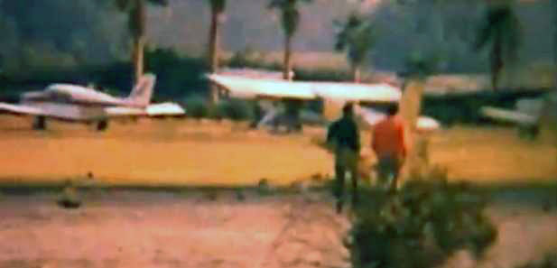
A still from the 1963 movie "It's A Mad, Mad, Mad, Mad World” of a scene shot at Palm Desert Airpark,
showing Charles Lane, Mickey Rooney, and Buddy Hackett in front of several aircraft.
Mike Ward recalled, “There used to be a great little grass field on a golf course in the mid-1960s with a great restaurant.
I flew in there many times. It was at Palm Desert.”

The only aeronautical chart depiction which is available of Palm Desert Airpark
was on the August 1965 San Diego Sectional Chart (courtesy of Ron Kunse).
It depicted Palm Desert as having a 3,000' unpaved runway.

A 1967 airdrome sketch (courtesy of Jonathan Westerling) depicted Palm Desert Airpark as having 2 unpaved runways,
measuring 3,000' east/west & 2,690' northwest/southeast.
The 1967 AOPA Airport Directory (courtesy of Jonathan Westerling)
described Palm Desert Airpark as having 2 grass 3,000' runways, oriented 8/26 & 13/31.

A still from a circa 1968 movie by W.R. Langley of a Goodyear blimp visiting the Palm Desert Airpark.
The last image located of Palm Desert Airpark was a still from a circa 1968 movie by W.R. Langley, showing a line of planes parked in front of palm trees.
According to a 4/6/60 L.A. Times article,
"Henry L. Gogerty operated the Desert Air Hotel & Palm Desert Airpark until 1968."
According to Barry Schiff's column “Those Good Old Days” in the April 2014 issue of AOPA Pilot,
“Like so many other airports, Palm Desert Airpark fell victim to escalating real-estate prices & was gobbled up by land developers in 1968.
There were many other such fly-in destinations that no longer exist, and the sad reality is that virtually no other airports were developed to replace them.
The same is true of almost every airport forced to close for whatever reason.
There used to be so many more places from which pilots could reach for the sky.
Every time an airport closes, those good old days look better & better.”
The 1971 USGS topo map continued to depict 2 runways labeled simply as “Landing Field”.
But the 1973 USGS topo map no longer depicted the airfield, instead showing a golf course covering the site.
Palm Desert Airpark was no longer listed among active airfields in the 1976 AOPA Airport Directory (according to Jonathan Westerling).
According to www.travelgolf.com, "Marriott Hotels & Resorts purchased the adjacent 27-hole Rancho Las Palmas Country Club in September, 1981.
It had initially been an 18-hole golf course called Desert Air.”

A 5/29/09 aerial photo showed no trace remaining of Palm Desert Airpark.
Cameron Sheperd reported in 2011, “I visited the site several years ago -
nothing left, except that the main fairway of the golf course seems to be aligned with the old northwest/southeast runway,
and there's a Desert Air Drive in the condos by the hotel.
Very ritzy, very posh, but it will never have the understated chillout class of the old place, with guest cottages made from recycled WW2 barracks huts.
I think the difference speaks volumes about the way this country has changed.”
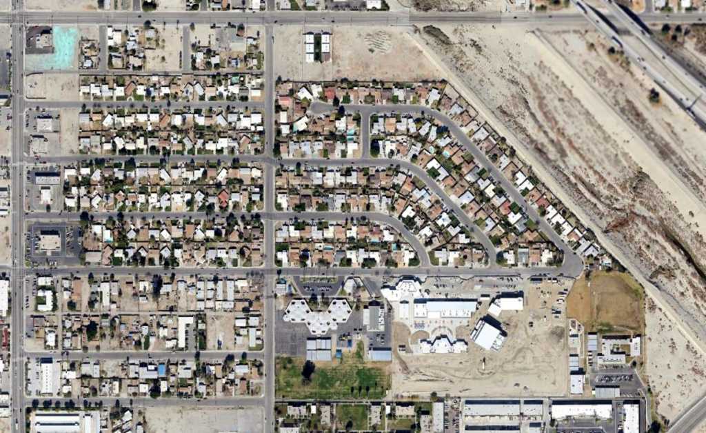
The site of Palm Desert Airpark is located west of the intersection of Monterey Avenue & Avenue Las Palmas.
____________________________________________________
(Original) Palm Springs Municipal Airport / Stevens Airport, Palm Springs, CA
33.827, -116.534 (East of Los Angeles, CA)

A 1928 photo of a Fokker Trimotor (labeled “Rio Grande”) & a Stinson Model B in front of the 2 hangars at the original Palm Springs Airport.
The date of construction for the original Municipal Airport for the town of Palm Springs has not been determined.
According to Cameron Shepherd, the airport was laid out "apparently in the 1920s."
The earliest depiction which has been located of the original Palm Springs Airport
was a 1928 photo of a Fokker Trimotor (labeled “Rio Grande”) & a Curtiss Condor in front of the 2 Palm Springs hangars.
The 1929 "Rand McNally Standard Map of CA With Air Trails" (courtesy of Chris Kennedy)
described the Palm Springs "Stevens Airport" as being operated by W. Seaton, and measuring 2,500' x 300' in size.

A 1931 photo of by Jim Seaton's father of Consolidated PT-3 biplanes in front of the 2 Palm Springs Airport hangars.
According to Jim Seaton, the photo was “taken by my father at the old Palm Springs Airport (Stevens Airfield),
where he managed the airport & flew sightseeing tours with his Ryan Brougham B1."
According to Cameron Shepherd, “The 2 box-like hangars in these photos are the ones that stood at the far north end of the apron on the west side of the field.
The north half of the field site is now covered by apartments so there's no trace left of those 2 hangars.”

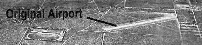
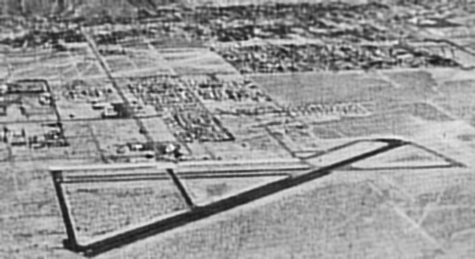
An undated (early 1930s?) aerial view looking northwest at the original Palm Springs Airport (courtesy of Cameron Shepherd).
Cameron Sherherd noted, the photo is “looking down the main northwest/southeast runway.
Probably soon after construction, when the seldom-used crosswind runway still stood out sharply.
The white terminal seen in later photos is not yet built - there is a collection of wooden buildings in the terminal area at the southwest corner of the field (bottom-left), as per earliest photos.
The 2 square hangars isolated at the north end of the ramp are also visible (bottom-right).
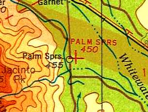
The 1934 San Diego Airway Chart depicted "Palm Sprs" as an auxiliary airfield.

A circa 1936 photo of what appear to be American Airlines DC-3s at the original Palm Springs Municipal Airport,
from the 1937/38 “Palm Springs Pictorial” (courtesy of Cameron Shepherd).
The original caption read, “The vision that is hoped to be a reality soon for the Palm Springs Airport: a regular port of call for major transcontinental air lines.
The photograph above was taken last season when inclement weather conditions made an emergency landing at Palm Springs necessary for one of the lines.”
An aerial photo looking southwest at the original Palm Springs Municipal Airport,
from The Airport Directory Company's 1937 Airports Directory (courtesy of Bob Rambo).
The directory described Palm Springs as a commercial airport having 3 sandy runways,
with the longest being the 3,400' northwest/southeast strip.
A hangar was said to have been marked with "Palm Springs" on the roof.
A circa 1930s-1940s aerial view looking east at the original Palm Springs Airport, courtesy of Cameron Shepherd.
In the above circa 1930s-40s aerial view of the original airport,
a collection of shadows (just to the left of the group of trees & buildings on the right)
could be interpreted as a taildragger aircraft in profile view.
In Cameron Shepherd's words, "You can see how the northeast-southwest runway surface has deteriorated.
It's sharpest in the earliest shots from the 1920s."
In 1939, with military preparations under way for the coming World War,
the Army started to lay out a much larger airfield just to the east of the original Palm Springs Airport.
This was eventually opened as the Palm Springs Army Airfield
(and this is the field which remains open today, as Palm Springs International Airport).
The original Palm Springs Airport remained open during WW2 as a civilian airport.

The original Palm Springs Municipal Airport was depicted as a commercial airport on the 1944 Sectional Chart,
which also depicted the newer Palm Springs AAF.
The 1944 US Army/Navy Directory of Airfields (courtesy of Ken Mercer)
described the original Palm Springs Airport as having a 3,200' unpaved runway.

By the time of the 1945 Mojave AAF Chart,
the original Palm Springs Municipal Airport was depicted with the symbol of an auxiliary airfield,
adjacent to the newer Palm Springs Airport.
A circa 1940s aerial view looking west at the original Palm Springs Airport (courtesy of Bill Wright).
The original Palm Springs Airport was no longer listed among active airfields in the 1945 AAF Airfield Directory (courtesy of Scott Murdock).

A pre-1946 image from a postcard (courtesy of Cameron Shepherd) looking west toward the mountains,
which shows the runway layout of the original Palm Springs Airport (at the bottom-left).
The original “Palm Springs Airport” was abandoned as of 5/23/46,
according to a June 1946 Department of Commerce Airman's Guide (according to Chris Kennedy).
By the time of the 1949 San Diego Sectional Chart (courtesy of Chris Kennedy),
the original Palm Springs Airport was no longer depicted at all.

A 1952 street map, on which Cameron Shepherd has superimposed
the presumed runway layout of the original Palm Springs Airport (on the left side),
and showing its location relative to the new Palm Springs Airport (on the right side).
"Note that East Andreas Road is the same as the old access road."
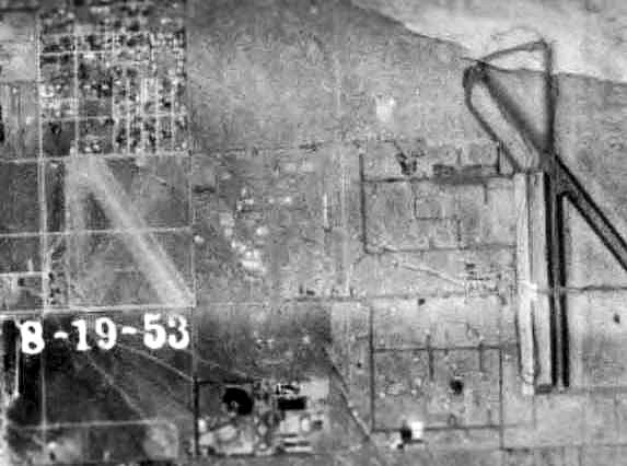
An August 1953 aerial photo (courtesy of Bob Anderson),
showing the relationship between the original Palm Springs Airport (on the left side)
with the new Palm Springs Airport (on the right side).
East Amado Road was built right across the old runways in the 1950s.

A circa-1950s postcard image looking east at the original Palm Springs Airport (courtesy of Cameron Shepherd).
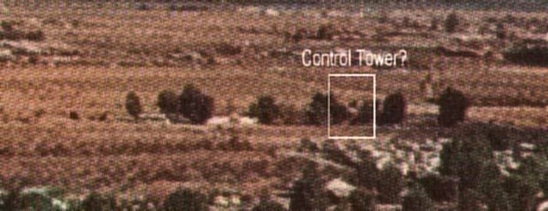
A close-up of the buildings from the circa-1950s postcard image of the original Palm Springs Airport (courtesy of Cameron Shepherd).
"The possible terminal building has a red roof & white walls.
This shows in other photos, and is consistent with municipal/commercial design in Palm Springs in the 1930s -
red tile roofs & whitewashed stucco.
Is that a WW2-style control tower peeking over the trees? It's not in the older shot."

Traces of the original Palm Springs Airport were still visible on the 1957 USGS topo map (courtesy of Kevin Walsh).
As Kevin Walsh pointed out, “The line of the old runway is still indicated as a dashed diagonal from about 'BM 466' to 'BM 433', beneath the 'M' & the 'GS'.”
A circa mid 1950s - mid 1960s aerial view (courtesy of Cameron Shepherd) looking west,
at the new Palm Springs Airport in the foreground
and the original Palm Springs Airport, whose pattern of runways was still visible in the background.
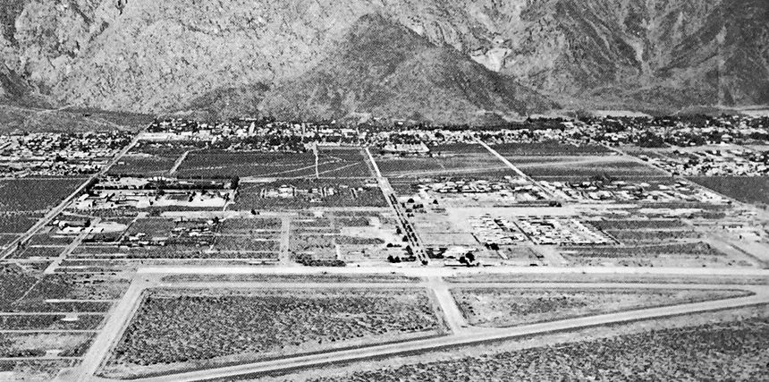
An undated aerial view looking west from a 1961-62 publication (courtesy of Kevin Walsh)
depicted the new Palm Springs Airport in the foreground, with the runways of the original Palm Springs Airport still recognizable in the background.

A 1994 USGS aerial view of the site of the original Palm Springs Airport
showed the former terminal area on what is now the northeast corner of Thaquitz & Avenida Caballeros has been developed.
It has not been determined if any of the buildings still at the site date from its airport days.
However, by closely examining the northeast corner of the above image,
what appears to be traces of the northwest/southeast runway are still visible
in the sand of the few undeveloped portions of the site.
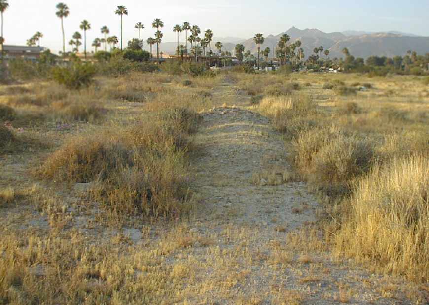
A 2005 photo by Cameron Shepherd, looking along a berm on the northwest side of the site of the runway.
Cameron reported, “Most of the southern half of the site is still undeveloped.
The airfield is quite a lot bigger 'in person' than it appears in the aerial photos.
I think it would have been no problem to get in & out in the biggest 4-engine ships.
No buildings [are] left - most of the old trees by the terminal site survived,
and part of the foundation of the large shed north of the terminal.
There is a very clear indication of the northwest edge of the main runway near the south threshold,
in the form of a large straight earth berm clearly dividing the big old bushes that date to the airport's time
from the small stunted bushes trying to grow since then on the runway surface,
which is still hard-packed & discolored by oil if you dig down about six inches.
The berm is sharply visible as a line with very high albedo in the current aerial photo of the spot.
I guess the earthen berms were supposed to catch wandering taildraggers?”
The Palm Springs Municipal Airport site is about to be built over,
so I've been trying to get all I can from it.”
Cameron Shepherd reported in 2013, “The north half of the field site is now covered by apartments so there's no trace left of the 2 hangars.”
Sal Sorrenti reported, “As of April 2016, what remained of the [original] Palm Springs Airport site has been paved over with asphalt & turned into a parking lot.
There is no longer any evidence of its existence.”

A 2016 aerial view showed no trace remaining of the original Palm Springs Airport.
The old Palm Springs Airport was bounded by present-day Thaquitz Canyon Way, North Sunrise Way,
East Alejo Road, and North Avenida Caballeros (which is quite possibly the old field's western perimeter road).
Thanks to Chris Kennedy for pointing out this airfield.
____________________________________________________
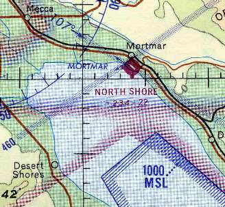
North Shore Airport, Mortmar, CA
33.52 North / 115.94 West (East of Los Angeles, CA)
North Shore Airport, as depicted on the 1966 San Diego Sectional Chart (courtesy of Chris Kennedy).
In a similar manner to what has happened to the former Navy Salton Sea seaplane base,
the rising waters of this inland sea have also swallowed up a small former general aviation airport, the North Shore airport.
It may have been associated with the Salton Sea Air Service,
which still provides seaplane flight instruction in the town of North Shore.
North Shore Airport was apparently built at some point between 1962-66,
as it was not yet depicted at all on the September 1962 San Diego Local Aeronautical Chart (according to Chris Kennedy).
The earliest depiction of North Shore Airport which has been located
was on the 1966 San Diego Sectional Chart (courtesy of Chris Kennedy),
which listed it as "North Shore (Beach Estates)".
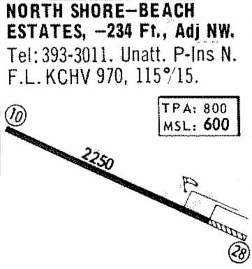
According to K.O. Eckland, North Shore Airport was described
in the 1968 Jeppesen Airport Directory as having a 2,250' paved runway.
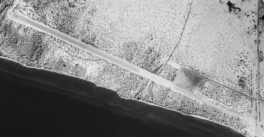
The only photo which has been located of the North Shore Airport during the period it was operational was a 4/16/72 USGS aerial view.
It depicted the field as having a single paved northwest/southeast runway with a ramp.
There were no buildings or aircraft at the airport.
Beach Estates Airport, as depicted in the 1974 Flight Guide (courtesy of Jonathan Westerling).
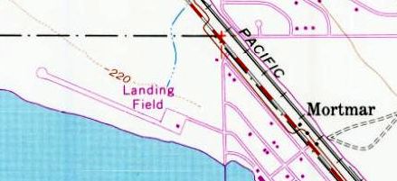
The runway was still depicted on the 1974 USGS topo map, but it was labeled simply "Landing Field".
"North Shore" Airport was described in the 1977 Pilot's Guide to CA Airports (according to Chris Kennedy)
as having a single 2,065' unpaved Runway 10/28.
It was apparently closed at some point between 1977-82,
as North Shore was not listed among active airports in the 1982 AOPA Airport Directory.
Bob Cannon recalled, "North Shore… I landed there a few times.
The last time I had to use the road because the strip was under water.
In fact the road disappeared under water.
That was a failed venture for someone."
The North Shore runway was still depicted on the 1986 USGS topo map, but it was labeled simply "Landing Field".
North Shore was still depicted as an abandoned airfield on the 1987 CA Aeronautical Chart (courtesy of John Voss)
and the 1989 LA Sectional Chart (courtesy of Chris Kennedy).
As can be seen in the 1995 USGS aerial photo,
by that point the rising water level had moved the shore of the Sea to roughly over the center of the former airport.
A portion of the runway was still evident along the western edge,
and the ramp area was still perceptible as well.
It was no longer depicted at all (even as an abandoned airfield) on 1998 aeronautical charts.
The North Shore runway was depicted as a road on the 2003 USGS topo map.

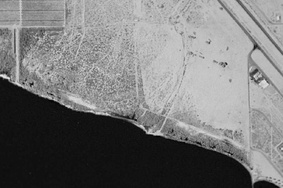
A 5/25/09 aerial view looking east showed a western portion of the North Shore runway still remained.

A December 2011 photo by John Acosta looking along the remains of the North Shore runway.
The site of North Shore Airport is located west of the intersection of Route 111 & Vander Veer Road.
____________________________________________________
Since this site was first put on the web in 1999, its popularity has grown tremendously.
That has caused it to often exceed bandwidth limitations
set by the company which I pay to host it on the web.
If the total quantity of material on this site is to continue to grow,
it will require ever-increasing funding to pay its expenses.
Therefore, I request financial contributions from site visitors,
to help defray the increasing costs of the site
and ensure that it continues to be available & to grow.
What would you pay for a good aviation magazine, or a good aviation book?
Please consider a donation of an equivalent amount, at the least.
This site is not supported by commercial advertising –
it is purely supported by donations.
If you enjoy the site, and would like to make a financial contribution,
you
may use a credit card via
![]() ,
using one of 2 methods:
,
using one of 2 methods:
To make a one-time donation of an amount of your choice:
Or you can sign up for a $10 monthly subscription to help support the site on an ongoing basis:
Or if you prefer to contact me directly concerning a contribution (for a mailing address to send a check),
please contact me at: paulandterryfreeman@gmail.com
If you enjoy this web site, please support it with a financial contribution.
This site covers airfields in all 50 states.