Abandoned & Little-Known Airfields:
Alaska
© 2003, © 2016 by Paul Freeman. Revised 11/23/16.
This site covers airfields in all 50 states: Click here for the site's main menu.
____________________________________________________
Please consider a financial contribution to support the continued growth & operation of this site.
Alexai Point Army Airfield (added 11/23/16) - Amchitka AAF / Amchitka AFB (revised 11/17/15) - Barrow Naval Arctic Research Laboratory Airfield (added 7/24/16)
Original Bethel Airport (revised 3/6/14) - Bethel Airport (2nd location) (revised 8/31/12) - Eightmile Lake Airfield (revised 9/19/11) - Ft. Glenn AAF / Otter Point NAF (revised 5/24/13)
Ft. Randall AAF Satellite Field (added 11/2/13) - (Original) Huslia Airport (revised 11/16/07) - Miller Army Airfield (revised 11/2/13) - Ogliuga Army Airfield (added 11/17/15)
Phillips Field (revised 9/20/14) - Sagwon Airport (added 5/22/16) - Shishmaref Airport (original location) (added 7/19/16)
Weeks Field (revised 3/27/16) - Western Shemya Army Airfield (revised 4/27/16)
____________________________________________________
Alexai Point Army Airfield, Attu Island, AK
52.816, 173.297 (Southwest of Anchorage, AK)
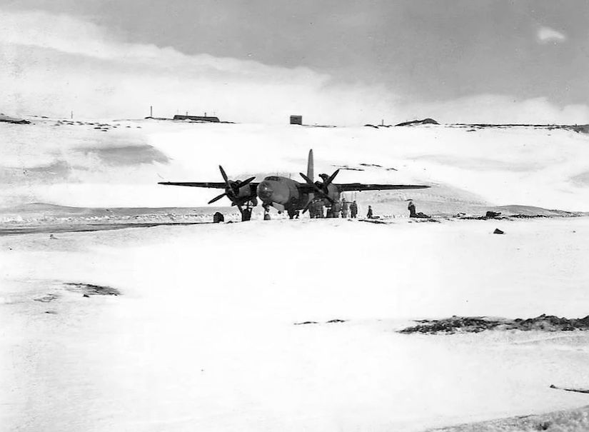
A 1944 photo of a Martin AT-23B Marauder on a snowy Alexai Point Army Airfield.
Attu Island is the westernmost island in the Aleutian Islands of Alaska,
and is significantly closer to mainland Russia than mainland Alaska.
According to Wikipedia, the 301st Independent Infantry Battalion of the Japanese Northern Army landed on Attu Island on 6/7/42, without opposition.
The 42 Attu inhabitants who survived the Japanese invasion were taken to a prison camp near Otaru, Japan, and 16 died during subsequent imprisonment.
American forces eventually returned to Attu on 5/11/43.
The Japanese, who knew the Americans were coming, had pulled back from their shoreline positions & moved to defensive positions on higher ground above the fog.
On 5/30/43, before the battle for Attu was completely over, the building of Alexai Point Airfield was initiated
using Marsden Matting to pave 2 runways on a narrow peninsula on the southeast shore of the island.
The first landing at Alexai Point Airfield was made by an 11th Air Force C-47 arriving on 6/8/43 to deliver fighter crews to Alexai Point & evacuate wounded soldiers.
Shortly afterwards, P-40 Warhawks from the 344th Fighter Squadron arrived to provide air cover over the island.
USAAF units assigned to Alexai Point Army Airfield were:
18th Fighter Squadron, 3/28/44-11/6/45 (P-38 Lightning),
54th Fighter Squadron, 11/20/43-3/8/46 (P-38 Lightning),
344th Fighter Squadron, 6/12/43 - December 1943 (P-40 Warhawk),
77th Bombardment Squadron, July–September 1943; 2/11/44-10/19/45 (B-25 Mitchell, B-26 Marauder).
Alexai Point Army Airfield was intially used for carrying out bombardment operations over Kiska Island during June & July 1943.
After the end of the Aleutian Islands Campaign in late August, Alexai Point & the new Shemya Army Airfield became forward bases for operations against the Kurile Islands of northern Japan.
Alexai Point became home of very long-range (VLR) P-38 Lightning squadrons, providing fighter escort for B-24 Liberators bombers based at Shemya.
By mid-July fighters from Alexai Point Airfield had made their first strike against Japan, a raid against the northern Kuril Islands.
The earliest depictions which have been located of Alexai Point Army Airfield were a series of 1944 photos of a variety of American military aircraft.
A 1944 photo of a Martin AT-23B Marauder on a Alexai Point Army Airfield runway.
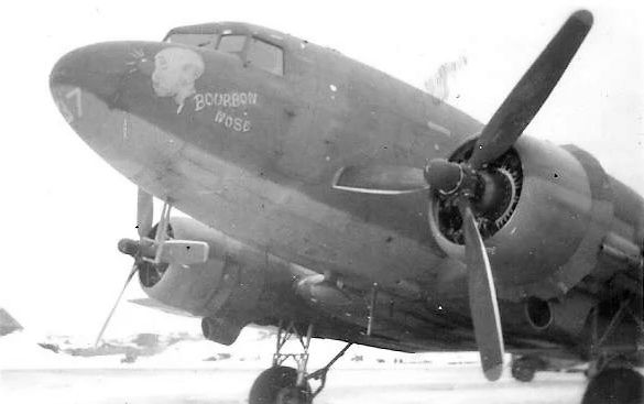
A 1944 photo of a Douglas C-47 Skytrain “Bourbon Nose” at Alexai Point Army Airfield.
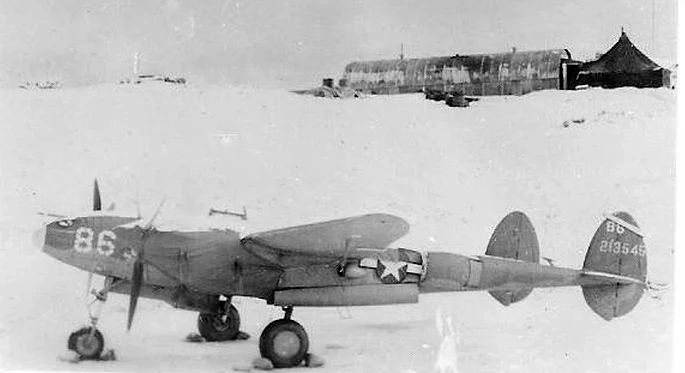
A 1944 photo of a Lockheed P-38 Lightning fighter at a snowy Alexai Point Army Airfield.
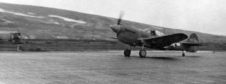
A 1944 photo of a Curtiss P-40 Warhawk fighter on a Alexai Point Army Airfield runway.
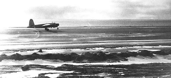
A 1944 photo of a Navy Lockheed PV-1 Ventura bomber on the Marsden Matting of Alexai Point Army Airfield.
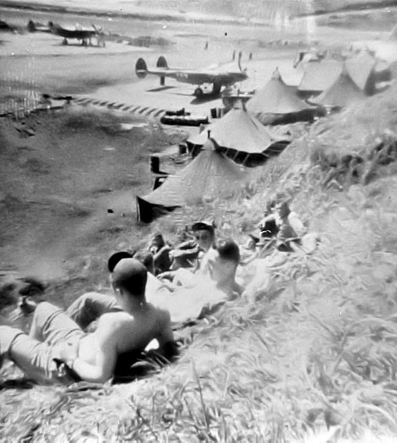
A summer 1943-45 photo of crews relaxing near Lockheed P-38 Lightnings at Alexai Point Army Airfield.
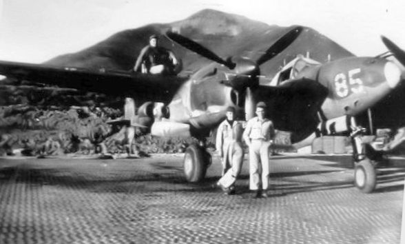
A summer 1943-45 photo of a crew with their Lockheed P-38 Lightning fighter on the Marsden Matting of Alexai Point Army Airfield.
With the end of the war in 1945, combat units were gradually withdrawn from Alexai Point Army Airfield.
The 11th Weather Squadron & the 713th Air Warning Radar Squadron remained until June 1946 when the base was closed.
The facility was abandoned, with most structures dismantled, the usable buildings being reassembled at Naval Air Station Attu.
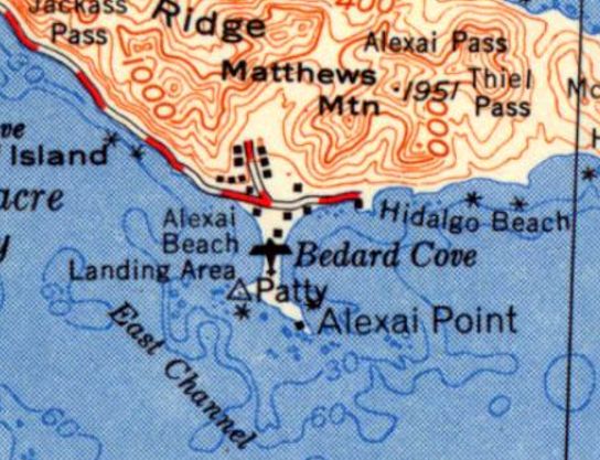
The 1952 USGS topo map depicted Alexai Point Army Airfield simply as a “Landing Area”.
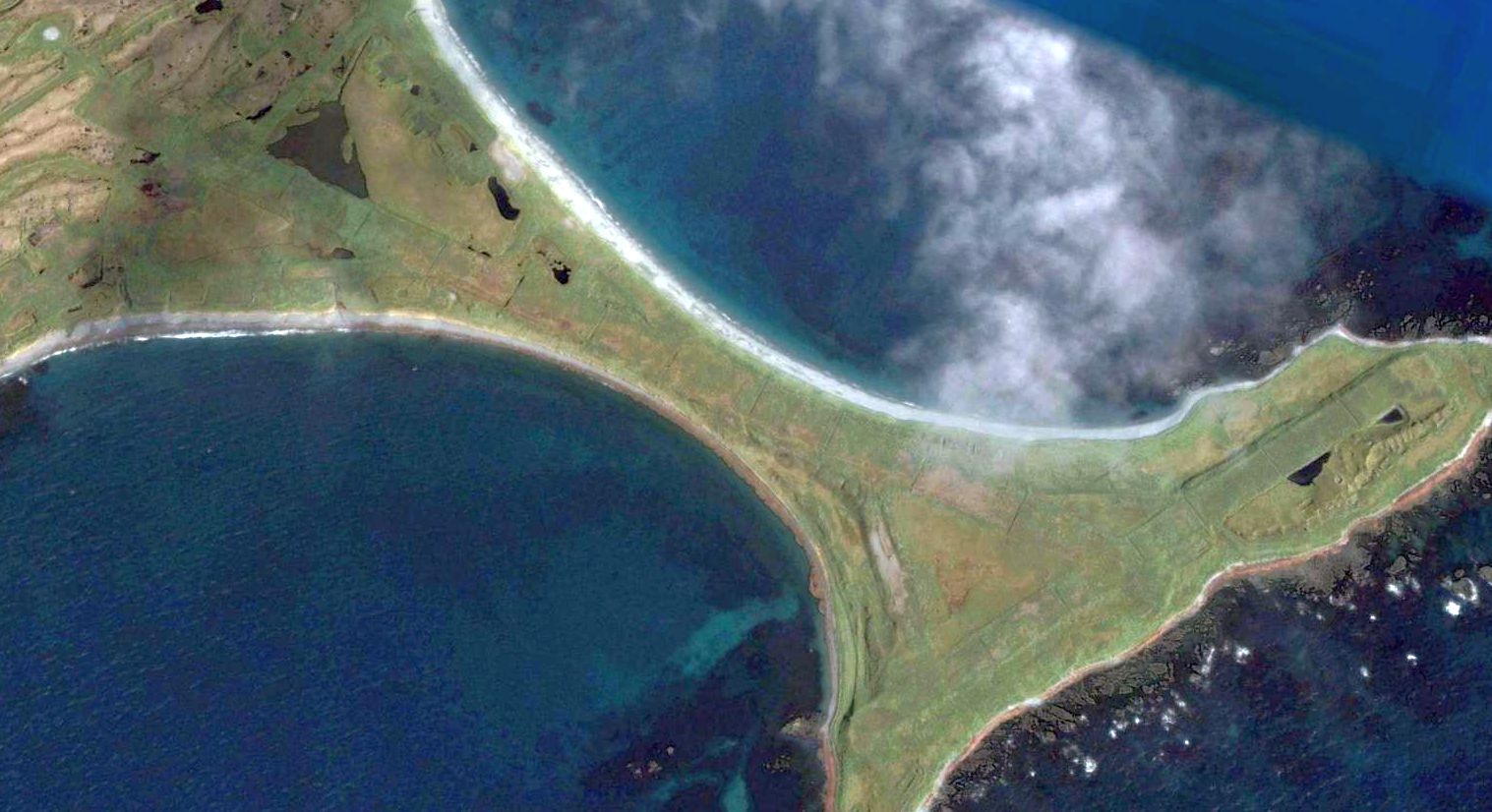
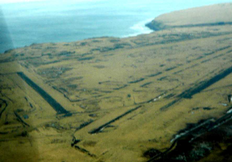
A 2006 aerial view looking northeast shows the 2 runways & taxiways of Alexai Point Army Airfield were still very recognizable.
Other remains include revetments, roads, and anti-aircraft gun emplacements.
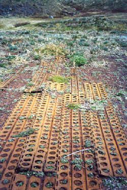
A 2006 photo of the Marsden Matting which remains at the site of Alexai Point Army Airfield.
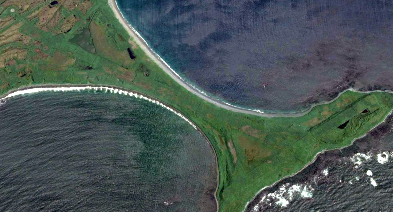
A 2011 aerial view looking northeast shows the 2 runways of Alexai Point Army Airfield were still very recognizable, 65 years after being abandoned.
____________________________________________________
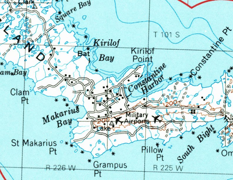
Barrow Naval Arctic Research Laboratory Airfield, Barrow, AK
71.339,-156.671 (North of Anchorage, AK)
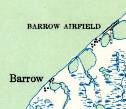
The Barrow Naval Arctic Research Laboratory Airfield, as depicted on the 1949 USGS topo map.
Located on the very northern tip of Alaska, the Barrow Naval Arctic Research Laboratory was established in 1947.
At some point between 1947-49 a small airfield was established to the northeast of the laboratory buildings.
The earliest depiction which has been located of the Barrow Naval Arctic Research Laboratory was on the 1949 USGS topo map.
It depicted “Barrow Airfield” as having a paved northeast/southwest runway & a shorted unpaved north/south strip.
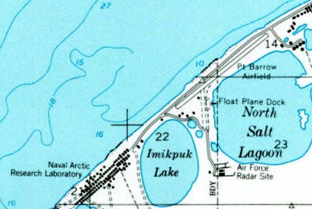
The 1955 USGS topo map depicted “Pt. Barrow Airfield” as having a paved northeast/southwest runway & a shorted unpaved north/south strip.
A float plane dock was depicted to the southeast, and the Air Force Radar Site was further south.
The date of closure of the Barrow Naval Arctic Research Laboratory (and its airfield) has not been determined.
In 1995 the buildings of the Barrow Naval Arctic Research Laboratory were reused as the home of Iḷisaġvik College.
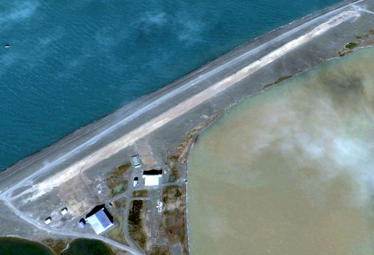
A 2005 aerial view looking north at the Barrow Naval Arctic Research Laboratory Airfield showed the paved northeast/southwest runway remained intact, along with 2 hangars.
According to Dave Noordeloos, “The hangar visible is huge & was still there when I visited in July 2011.
The residents of Barrow now periodically use the old runway to butcher whales.”
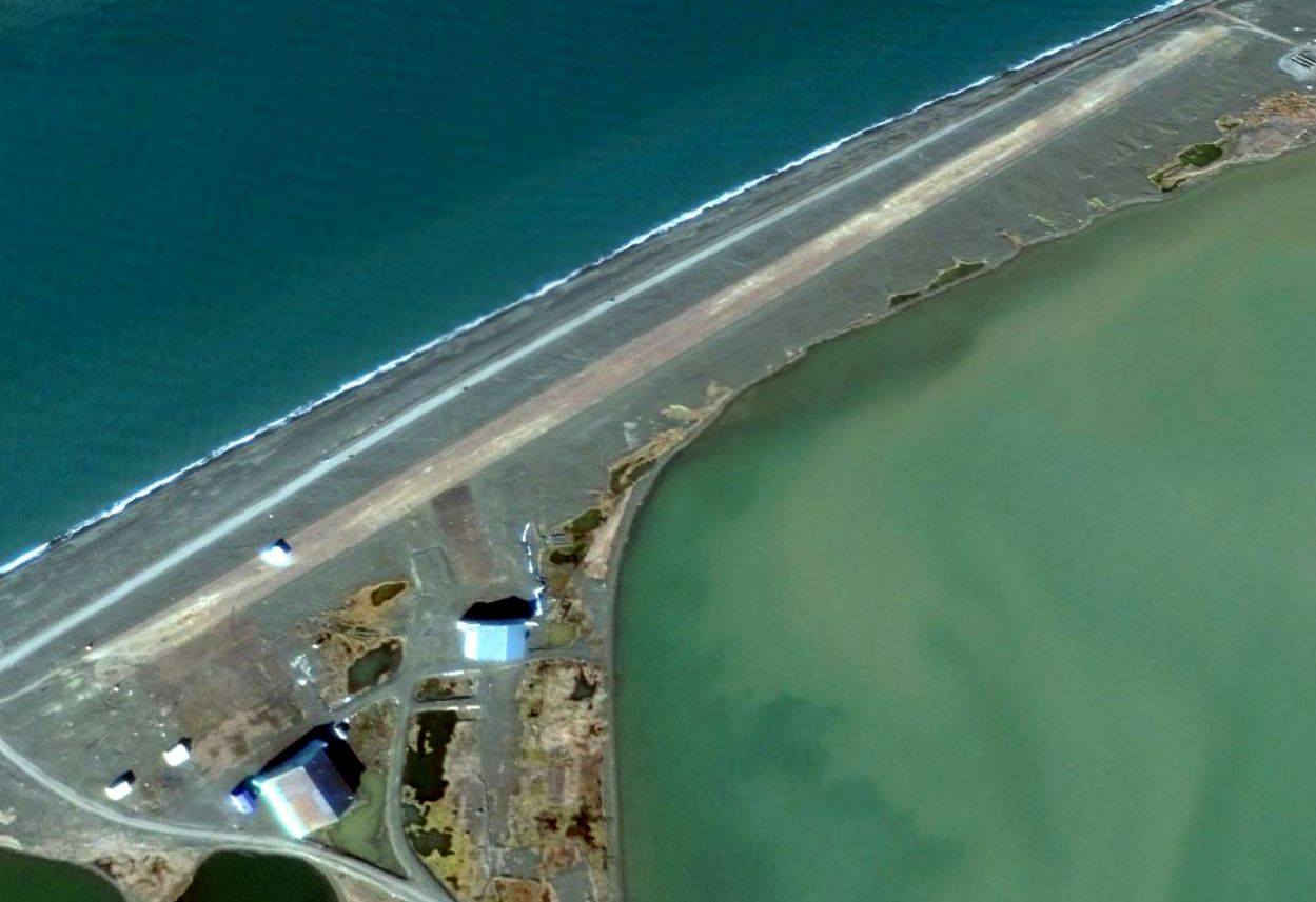
A 2014 aerial view looking north at the Barrow Naval Arctic Research Laboratory Airfield showed the paved northeast/southwest runway remained intact, along with 2 hangars.
Thanks to Dave Noordeloos for pointing out this airfield.
____________________________________________________
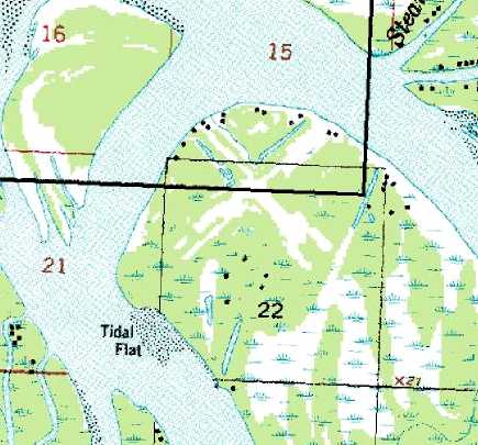
Shishmaref Airport (original location), Shishmaref, AK
66.256, -166.058 (Northwest of Anchorage, AK)
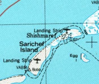
The original location of Shishmaref Airport (the “Landing Strip” on the northeast part of the island), as depicted on the 1950 USGS topo map.
Located on the small island of Sarichef off the coast of Alaska near the Arctic circle, only 87 NM from mainland Siberia,
the tiny village of Shishmaref is a century-old Inupiat Eskimo village whose economy depends partly on subsistence fishing & hunting.
The date of establishment of Shishmaref's original airport has not been determined.
The earliest depiction which has been located of Shishmaref Airport was on the 1950 USGS topo map.
It depicted a “Landing Strip” on the northeast part of the island, along with another Landing Strip on the southwest part of the island.
Shishmaref's original airport had to be closed due to erosion on 6/17/05.
The original airport's north/south runway ran across the narrow width (only 2,000') of the island, but too much land was lost to maintain a long enough runway.
Climate change had caused the Chukchi Sea, which surrounds the island, not to freeze before the arrival of the fierce fall storms, as it had for centuries, leaving the island unprotected.
In the decade before the airport's closure, hundreds of feet of shore as well as several houses had been lost to the storms.
A new Shishmaref Airport was built less than a half-mile to the southwest, but aligning the new airport's runway with the island's predominant southwest/northeast axis
put the runway perpendicular to the prevailing winds, causing it to have a direct crosswind during most flight operations.
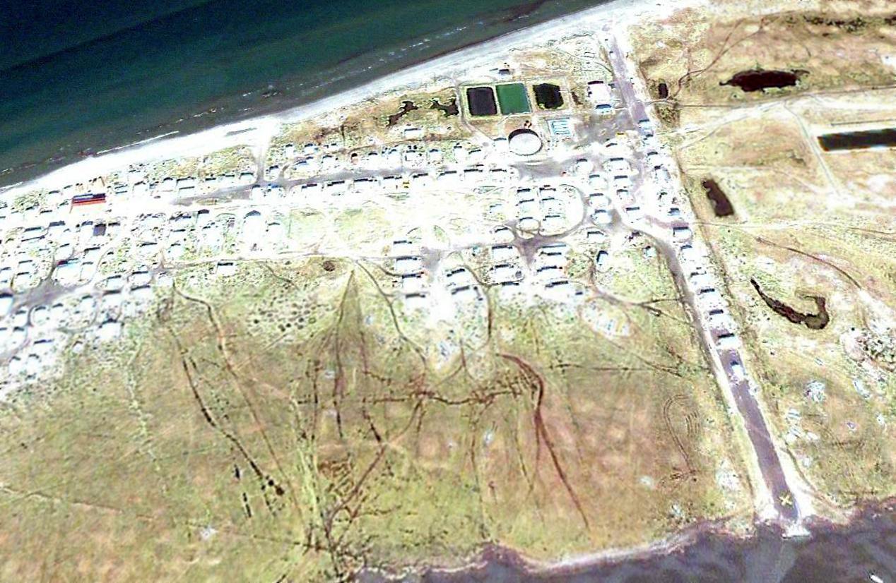
After closure of the original Shishmaref Airport, houses were subsequently built on the former runway.
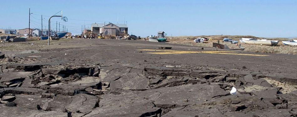
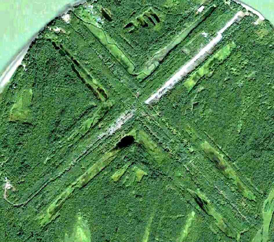
An undated (2005-2016) photo of the runway remains of the original Shishmaref Airport, showing a closed-runway “X” symbol,
and the broken-up pavement due to the shoreline erosion which closed the airport.
An undated (2005-2016) aerial view looking north along the runway remains of the original Shishmaref Airport.
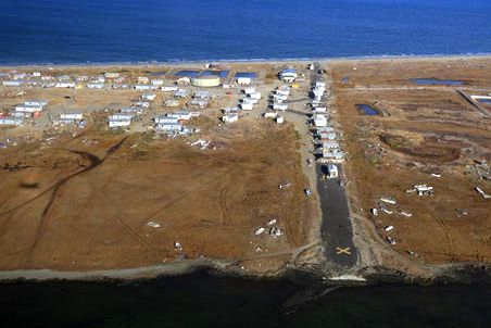
A 2008 aerial view looking north at the remains of the original Shishmaref Airport, showing a closed-runway “X” symbol on the southern end of the former runway.
The village of Shishmaref will eventually have to be evacuated within the next few years if the shoreline erosion continues.
____________________________________________________
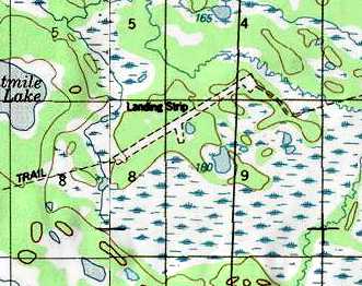
Sagwon Airport (SAG), Sagwon, AK
69.378, -148.689 (South of Prudhoe Bay, AK)
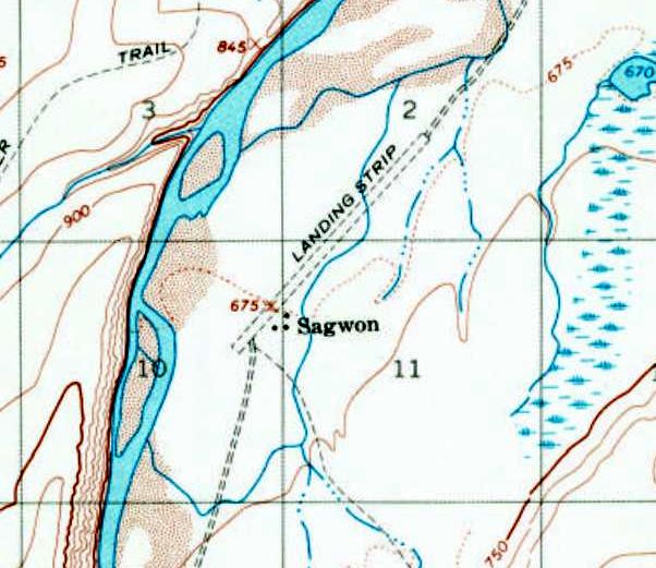
Sagwon Airport, as depicted on the 1971 USGS topo map.
This remote airfield in the Alaskan interior 56 NM south of Prudhoe Bay was evidently established at some point between 1955-71,
as it was not yet depicted on the 1955 USGS topo map.
The earliest depiction which has been located of Sagwon Airport was on the 1971 USGS topo map,
which depicted a single unpaved northeast/southwest runway, labeled simply as “Landing Strip”,
with 3 small buildings on the southeast side.
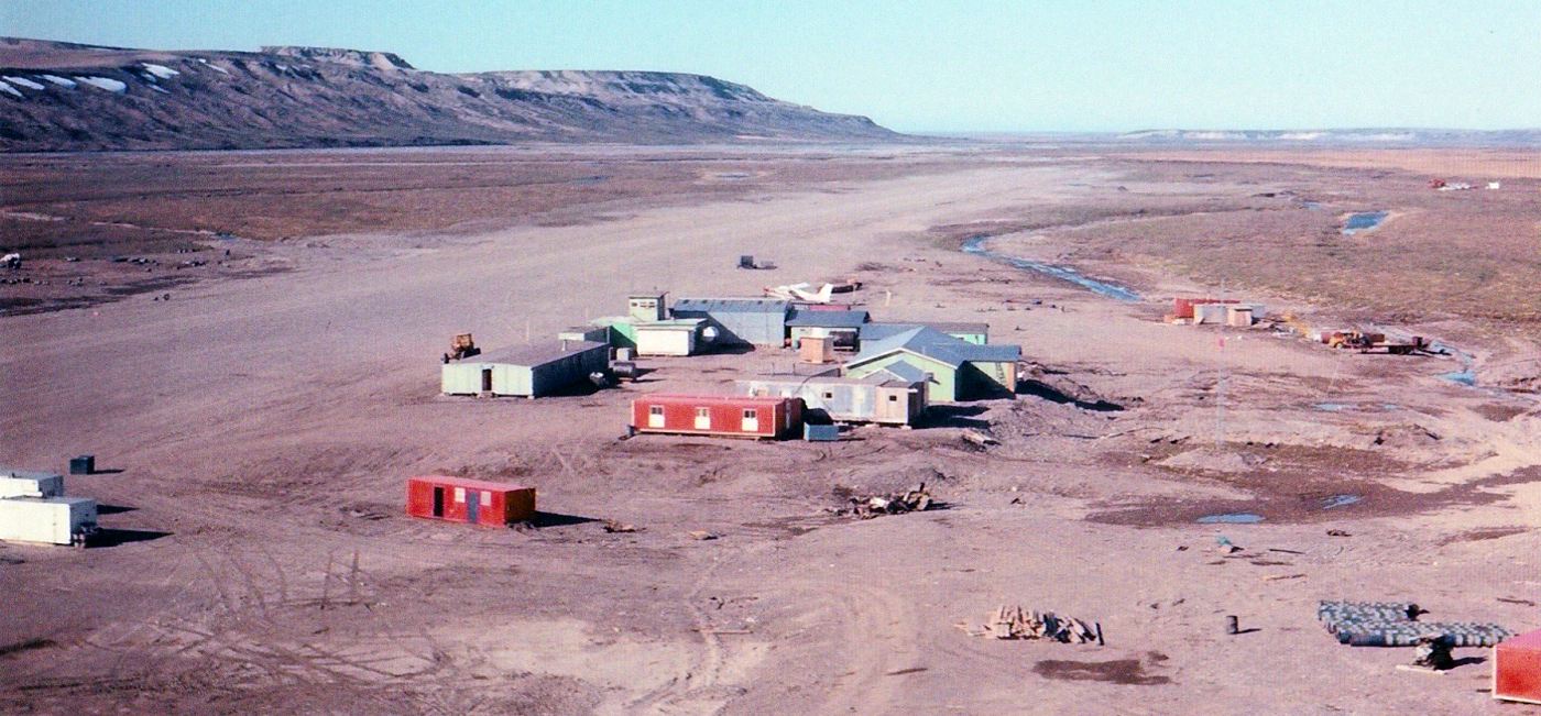
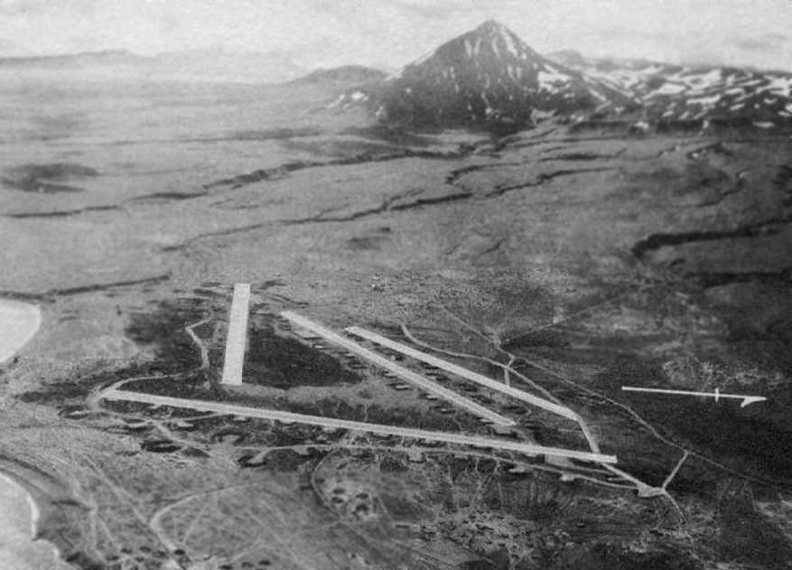
A summer 1972 aerial view by Francis Blake looking north at Sagwon Airport, showing the unpaved runway, several buildings, and a de Havilland DHC-2 Beaver.
Francis Blake recalled, he was at Sagwon “in the summer of 1972 for a couple of months.
I have no idea when it was constructed (likely late 1960s when oil exploration began).
A small 'town', a supply point and staging area, existed when in operation.
Arctic Alaska was indeed very remote then.
If any of the crew were left behind anywhere for whatever reason (collected rock samples had priority over humans),
a large bundle of survival gear was taken out of the helo. And a rifle of puny caliber. Grizzly bears are not uncommon.
I was left behind once on a hill top; took hours to return to fetch me.
Walking on tundra was almost impossible; something like trying to walk on a floor covered with partially inflated soccer balls with water in between.”
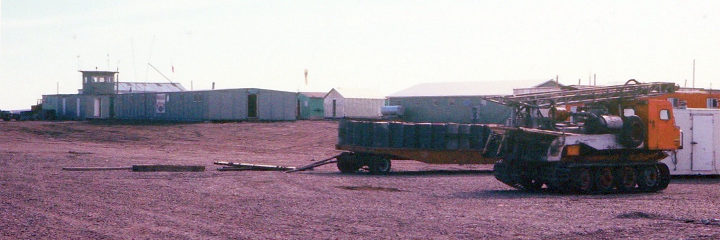
A summer 1972 photo by Francis Blake of the Sagwon Airport buildings, including its control tower.
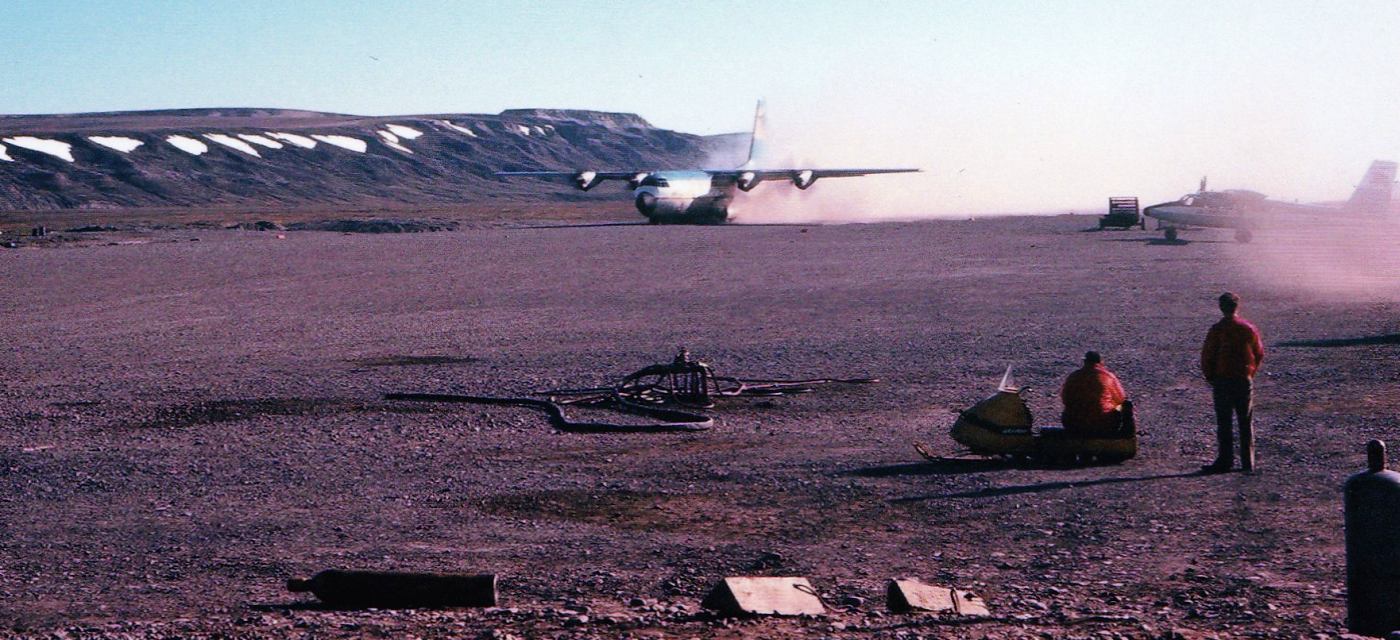
A summer 1972 photo by Francis Blake of a Lockheed L-100 Hercules (a civilian C-130) taking off from Sagwon Airport,
with a de Havilland Twin Otter visible at right.
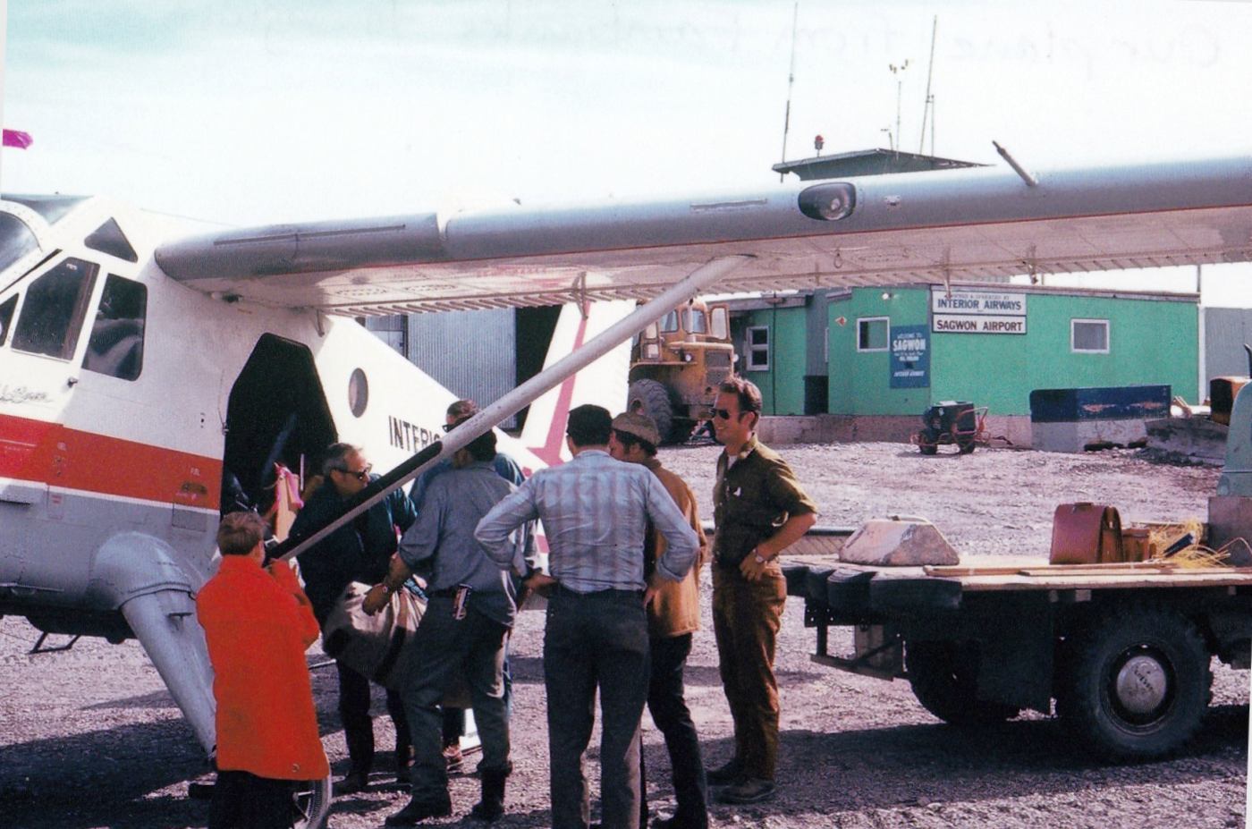
A summer 1972 photo by Francis Blake of an Interior Airway de Havilland Beaver at Sagwon Airport, “our plane from Fairbanks to Sagwon.”
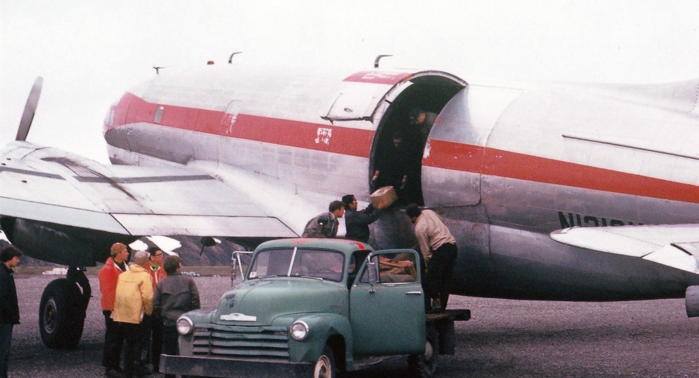
A summer 1972 photo by Francis Blake of a Curtiss C-46 Commando at Sagwon Airport.
Francis recalled that “WW2 C-46s & C-47s were our cargo carriers.”
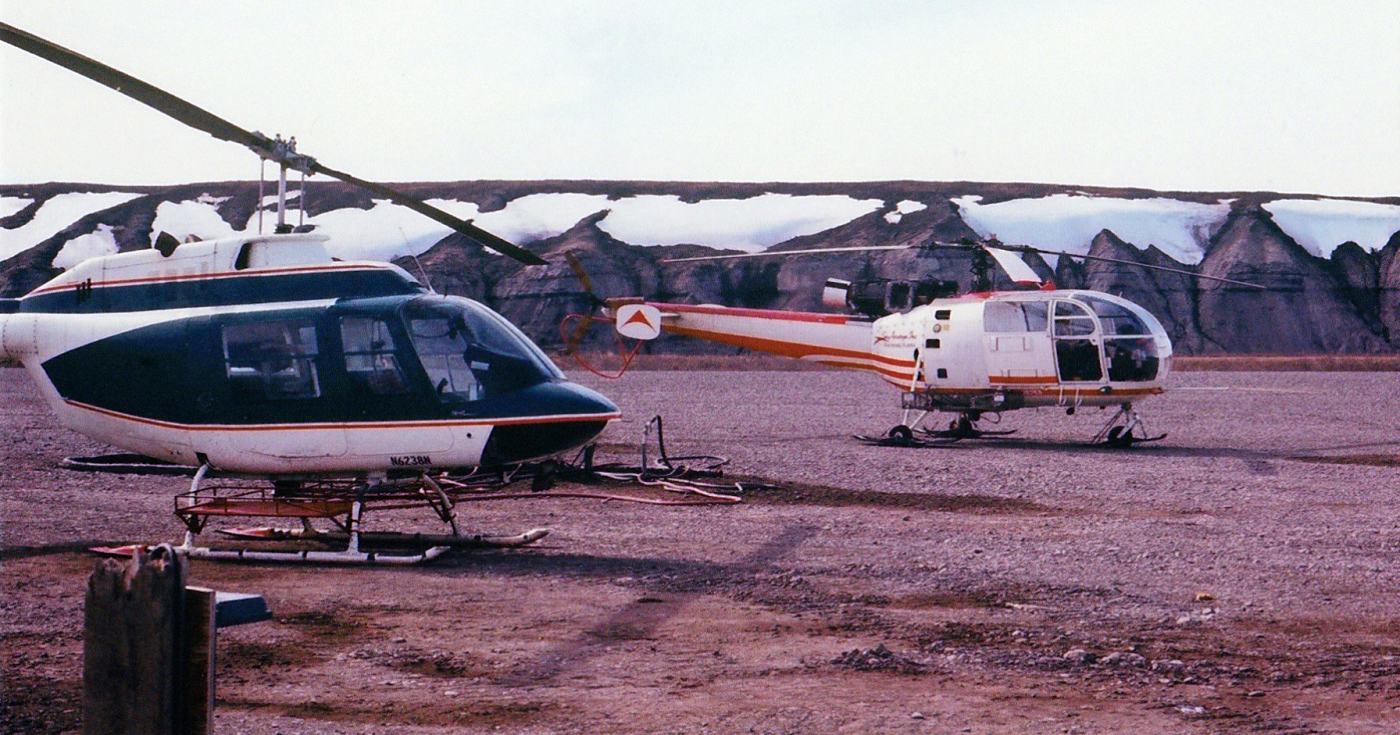
A summer 1972 photo by Francis Blake of “other company helos” at Sagwon Airport: a Bell Jet Ranger & an Aérospatiale Alouette III.
Francis recalled, “Ours was a red & white Bell Jet Ranger.”
Francis Blake recalled of Sagwon Airport, “I have no idea when it was abandoned. The Dalton Highway bypasses it.”
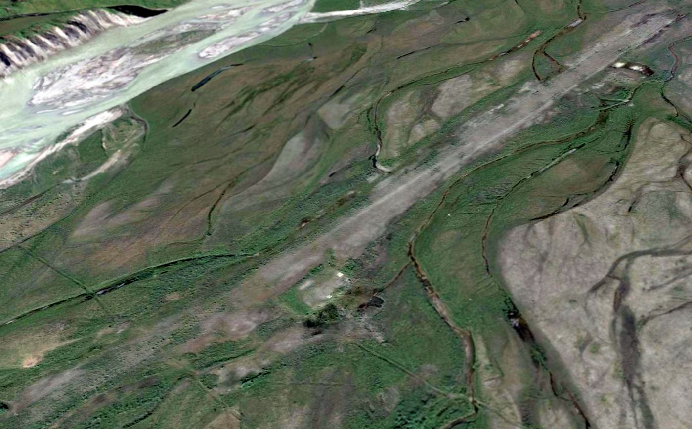
A 2014 aerial view looking north at Sagwon Airport showed the runway remained recognizable though somewhat overgrown.
There appears to be a few small building (or foundation) remaining on the southeast side.
As of 2016, Sagwon Airport is no longer charted as an active airfield.
Thanks to Francis Blake for pointing out this airfield.
____________________________________________________
Ogliuga Army Airfield, Ogliuga Island, AK
51.606, -178.656 (Southwest of Anchorage, AK)
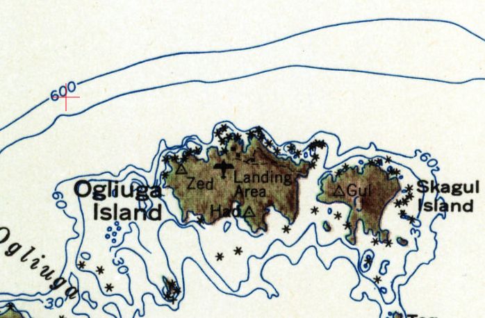
Ogliuga Island AAF was labeled as a “Landing Area” on the 1951 USGS topo map.
Photo of the airfield while in use has not been located.
Ogliuga Island is located at the far western end of the Aleutian Island chain, being located closer to mainland Russia than mainland Alaska.
According to Wikipedia, “Ogliuga Island AAF was established in 1942 as a result of the Japanese invasion of the Aleutian Islands.
Its primary use was as an emergency landing field by USAAF & Naval Air aircraft during the campaign, not having any permanent units assigned.”
According to the U.S. Navy's “Building the Navy's Bases in World War II', “Construction of the emergency landing field
established at Ogliuga for the Army in July 1943, was performed entirely by Seabees.
A 3,000' x 100' runway & four 100'-square parking areas were constructed, with a surface of steel matting.
The only other construction at Ogliuga was a small building for living quarters.”
It has not been determined if Ogliuga Island AAF was ever actually used by any aircraft.
According to Wikipedia, Ogliuga Island AAF “was abandoned after World War II.”
The earliest depiction which has been located of Ogliuga Island AAF was on the 1951 USGS topo map, which labeled it simply as “Landing Area”.
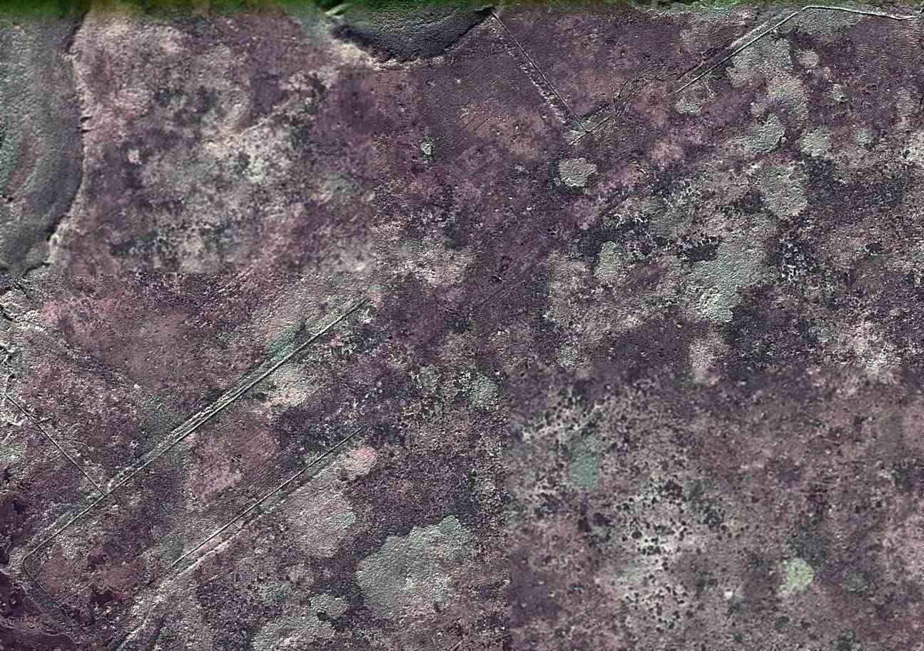
A 2010 aerial photo depicted the remains of a northeast/southwest runway at the site of Ogliuga Island Army Airfield.
According to Wikipedia, “Only some foundations of buildings & the remnants of 2 runways remain.”
Thanks to John Voss for pointing out this airfield.
____________________________________________________
Amchitka Army Airfield / Naval Air Facility Amchitka / Amchitka Air Force Base, Amchitka Island, AK
51.38, 179.27 (Southwest of Anchorage, AK)
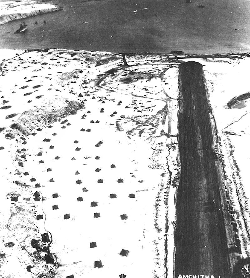
A 3/3/43 aerial view looking east along the Amchitka AAF runway, with personnel tents on the snowy hill to the north of the runway.
According to Wikipedia, American forces made an initially unopposed landing on Amchitka Island on 1/12/43.
Despite facing difficult weather conditions and continual bombing attacks from the Japanese, Army engineers managed to build a runway.
As more troops were landed, heavy construction equipment was brought ashore.
Frozen lakes were drained & the gravel scraped from their beds was used to lay down the bed for a runway.
On 2/16/43 the construction of the first runway at Amchitka (Code Name A-3, oriented east/west) had progressed to the point where light fighters could be brought in.
This airfield was also known as “Fox”, according to the University of AK Fairbanks.
Eighteenth Fighter Squadron Curtis P-40 Warhawks began to arrive from Adak & surprised the Japanese by launching counter-attacks to their raids from Kiska.
Two Japanese light bombers were shot down over the airfield in full view of the construction engineers.
In addition to the P-40s, several Lockheed P-38 Lightnings arrived.
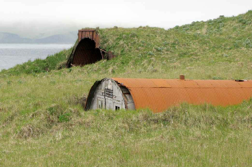
To the north of the main World War II runway were constructed a large number of roads & Quonset huts, and possible temporary aircraft maintenance hangars.
To the south of the main World War II runway were constructed numerous taxiways & a large number of aircraft revetments, likely dating from the Aleutian Campaign.
The aircraft parking was dispersed over a wide area almost to the south shore of the island connected by a taxiway & road network.
As the airfield was attacked on several occasions by Japanese aircraft, the wide dispersal was needed for defense.
Also constructed were a large number of anti-aircraft artillery sites, ammo dumps & other facilities.
The adverse weather conditions included much fog & this caused the loss of many aircraft.
To counter this Fog Investigation & Dispersal Operation (FIDO) was installed on runway Baker (the bomber runway) and it became operational in mid-June 1944.
It was used on several occasions, allowing successful take-off & landing in foggy conditions that would otherwise have prevented safe operations.
With its establishment, the Alaska Command was now 50 miles away from their target, Kiska.
The military eventually built numerous buildings, roads, and a total of 3 airstrips on the island.
At its peak, the occupancy of Amchitka Army Airfield reached 15,000 troops.
Known USAAF units assigned to Amchitka AAF were:
HQ IX Bomber Command, 6/24-9/4/43, HQ 343rd Fighter Group,
7/25/43–1/22/44, 11th Fighter Squadron, 3/27-5/17/43 & 3/23/44-July 1945 (P-40 Warhawk),
18th Fighter Squadron, 2/15/43-3/28/44 (P-40 Warhawk & P-38 Lightning),
54th Fighter Squadron, 3/12-10/18/43 (P-38 Lightning),
344th Fighter Squadron, May-July 1943 (P-40 Warhawk & P-38 Lightning),
632rd Bombardment Squadron (Dive), 7/19-8/1543 (A-24 Banshee),
633rd Bombardment Squadron (Dive), 7/19-8/15/43 (A-24 Banshee),
635th Bombardment Squadron (Dive), 7/19-8/15/43 (A-24 Banshee),
21st Bombardment Squadron, 2/18 - July 1943 (LB-30 & B-24 Liberator),
36th Bombardment Squadron, 5/4-9/13/43 (B-24 Liberator),
73rd Bombardment Squadron, March–April 1943; 6/30 - August 1943 (B-25 Mitchell & B-26 Marauder),
77th Bombardment Squadron, 9/11/43-2/11/44 (B-25 Mitchell & B-26 Marauder),
404th Bombardment Squadron, 6/4/43-2/26/44 (B-24 Liberator).
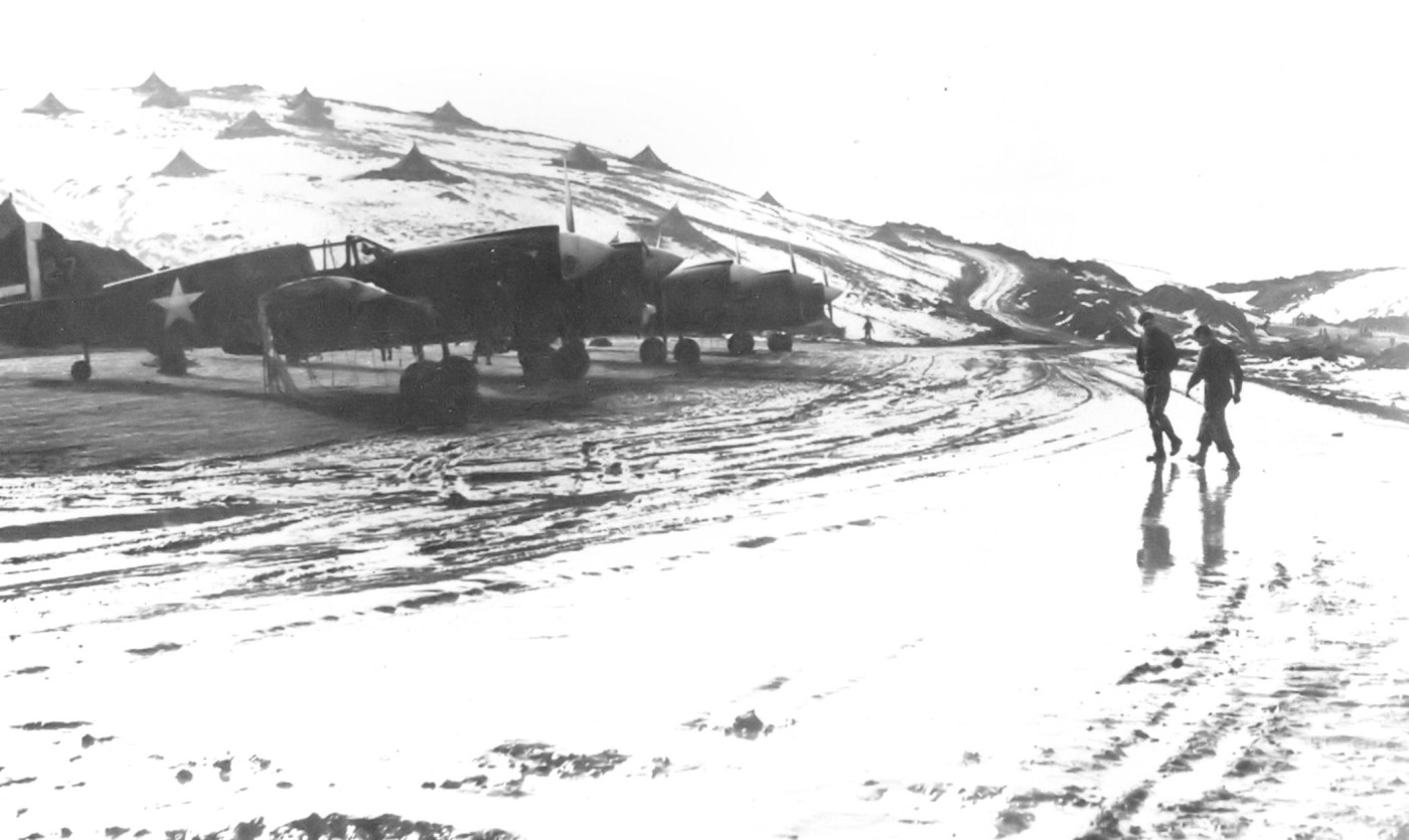
The earliest photo which has been located showing aircraft at Amchitka AAF was a March 1943 photo of 18th Fighter Squadron Curtis P-40s, with personnel tents on the snowy hill to the north of the aircraft.
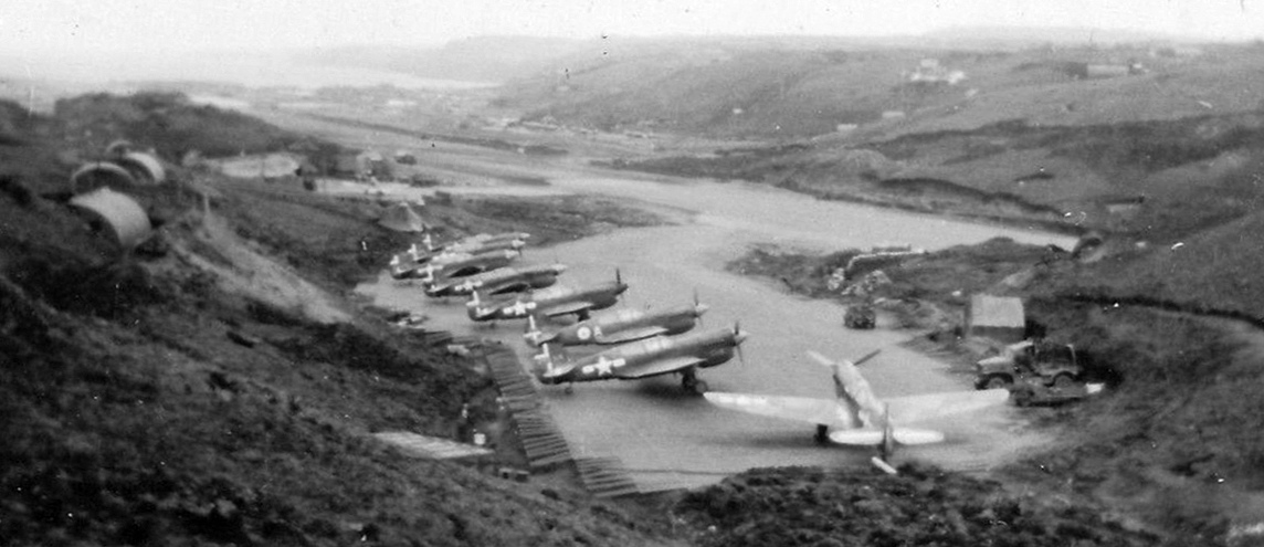
A circa 1943 aerial view looking east at Amchitka AAF showing 8 Curtiss P-40 Warhawks (courtesy of John Voss).
Note the 3rd P-40 from the front is a P-40K from the Royal Canadian Air Force's 111 Squadron.
With the establishment of an American base on Amchitka, the Japanese forces on Kiska Island were put into an untenable situation.
The Battle of the Komandorski Islands, fought on 3/27/43, sealed their fate.
The Japanese, in an attempt to reinforce & resupply their garrison on Attu had dispatched 3 transports which were escorted by 9 warships.
The Japanese commander lost his nerve when he feared American bombers on Amchitka, based on intercepted American radio signals, were preparing to attack.
He ordered his fleet to return to Japan. However, his fears proved groundless as the American aircraft were being prepared for a raid on Kiska island.
Without unloading the bombers & adding external tanks, the 73rd Bombardment Squadron B-25 Mitchells & B-26 Marauders on Amchitka
would have insufficient range to attack the Japanese in the battle area.
This amounted to a strategic defeat, as it ended Japanese attempts to resupply the Aleutian garrisons.
The Americans had essentially isolated the Japanese forces in the Aleutians & their days were numbered.
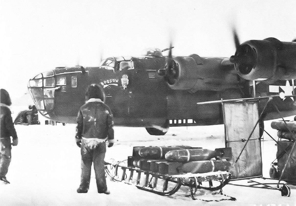
A March 1943 photo of sleds being used to transport bombs to a 21st Bomb Squadron B-24 Liberators at Amchitka AAF.
From its bases on Amchitka, 11th Air Force conducted continual bombing raids on the Japanese on Kiska & Attu.
Long-range B-24 Liberator heavy bombers were moved down from mainland Alaskan bases to operate in the Aleutians
which enabled Air Force commanders to send the bombers with full loads to Attu,
while the B-25 & B-26 medium bombers attacked Kiska several times each day.
Between April 1 & May 11, the 11th Air Force bombers & fighters reached its highest peak of operational activity during its bombing campaign.
Most attacks were directed against Kiska because of Attu being weathered in.
The close proximity of Amchitka allowed the fighters to participate in the attacks & run low-level sweeps over the Japanese positioned on Kiska.
P-38 Lightnings also carried two 500 pound or occasionally one 1,000 pound bomb
and employing glide-bombing tactics went after specific targets such as hangars & fuel tanks; the B-24 bombers dropped their loads on wide-area targets.
Fighters also carried out attacks using 20 pound fragmentation & incendiary bombs.
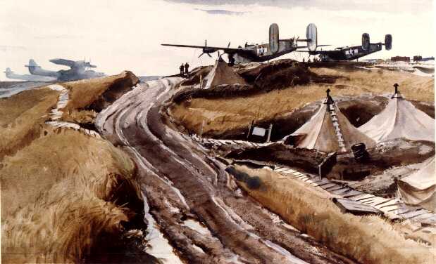
A painting of a WW2 scene of B-24 Liberator bombers & PBY Catalinas at Amchitka AAF.
Air support for the Battle of Attu, which took place from 5/11-5/30/43 was carried out from Amchitka.
The battle, which lasted for more than 2 weeks, ended when most of the Japanese defenders were killed in brutal hand-to-hand combat after a final banzai charge broke through American lines.
Air attacks on the Japanese on Kiska continued from Amchitka, with the culmination being the unopposed United States landing on Kiska on August 15.
The Aleutian Islands campaign was successfully completed on 8/24/43.
In that month, a strategic intercept station was established on the island.
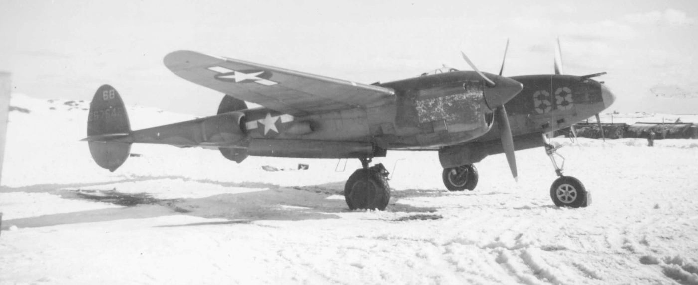
A WW2 photo of an Army Air Forces Lockheed P-38 Lightning fighter at Amchitka AAF (courtesy of John Voss).
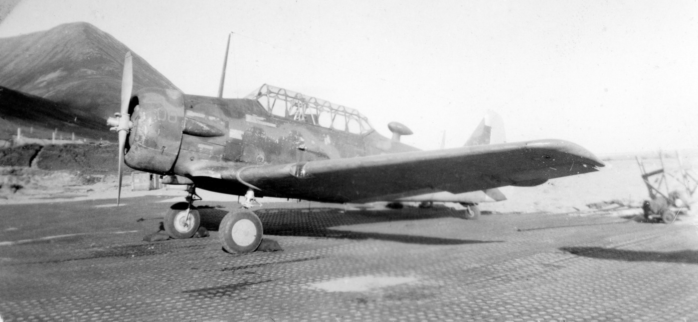
A WW2 photo of a very weather-worn looking North American T-6 Texan trainer at Amchitka AAF (courtesy of John Voss).
What would a trainer have been doing at such a remote location?
A 1943 photo of a Navy Consolidated PBY patrol amphibian (loaded with 2 bombs underwing) at Amchitka AAF (courtesy of John Voss).
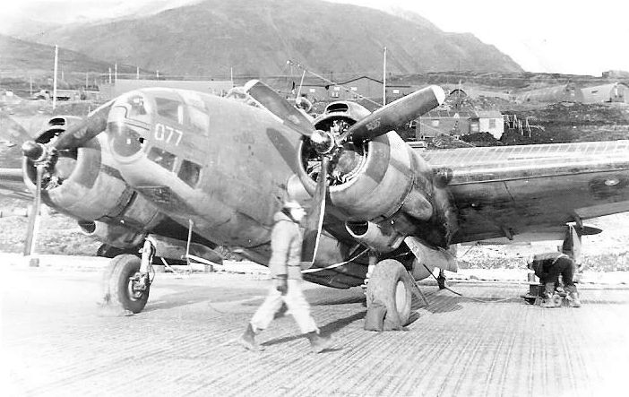
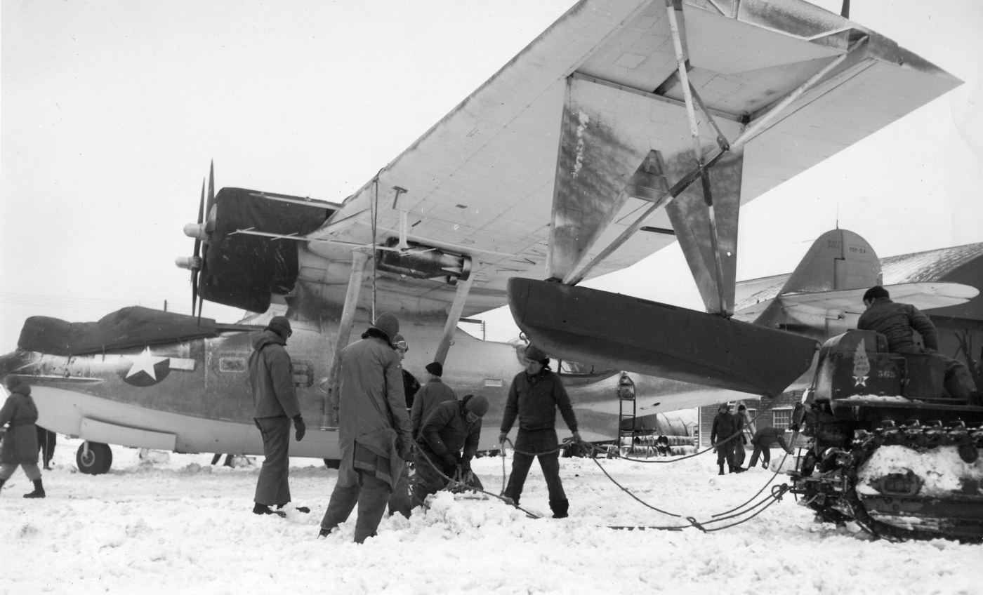
A 12/7/43 photo of 4 Navy Lockheed PV-1 Ventura patrol bombers in front of 2 hangars at Amchitka AAF (courtesy of John Voss).
Most combat squadrons were withdrawn by early 1944, the 11th Fighter Squadron becoming the headquarters garrison of the base until the end of the war.
The mission of Amchitka AAB was that of a communications facility
and also refueling for support & combat aircraft headed to & from Alexai Point Army Airfield on Attu & Shemya Army Airfield.
Amchitka's strategic intercept station remained in operation until February 1945.
On 7/1/47 the Aleutian Section of Alaskan Air Command was inactivated & Amchitka AAF was reassigned to Strategic Air Command.
Under SAC control, the field's mission was to provide refueling to SAC long range aircraft
and to Air Transport Command cargo flights between Japan & the Continental United States.
The base also compiled data by the 11th Weaather Squadron, Air Weather Service, and assisted in Air Rescue & Recovery missions.
The base had one C-47 permanently assigned.
The main World War II runway (7/23) was extended to 8,000' by SAC after WW2 to accommodate B-29s & MATS intercontinental transports.
A 6,000' secondary north/south runway was later constructed to the east,
and to the east of the runway were a series of personnel billeting or aircraft technical sites, and a possible port facility.
SAC or MATS received funding for a third 7,000' northeast/southwest runway to the north side of the main airfield at some point after WW2.
According to the University of AK Fairbanks, Amchitka's 2nd & 3rd runways were designated "Charlie" & "Baker",
and as of the late late 1940s runway "Charlie" was at that time the world's longest runway, at 10,000'.
An undated topo map depicted all 3 Amchitka military runways, along with their extensive network of taxiways & aircraft revetments.
Amchitka was redesignated Amchitka Air Force Base with the establishment of the United States Air Force in September 1947.
The facilities of the postwar SAC / MATS Amchitka Air Force Base were largely north of the 3rd runway.
SAC Operations ceased at Amchitka in February 1949 when the base was put into a caretaker status.
On 12/31/49 the base was closed due to insufficient personnel & staff.
The Army closed its communications facility at Amchitka in August 1950.
On 12/31/50 the 2107th Air Weather Group pulled the last of its personnel out of Amchitka & the facility was abandoned.
The 1951 USGS topo map depicted 2 “Military Airports” at Amchitka.
Amchitka hosted an Air Force White Alice telecommunication system in 1959-61, built on Kirolof Point to the north of the airfield.
Amchitka also hosted a temporary relay station in the 1960s & 1970s.
In the mid-1960s, the Atomic Energy Commission (AEC) used Amchitka for a series of underground nuclear tests.
New facilities were built in the 1960s by the AEC, which also reused the old AFB as its main base station.
In the 1960s a new 5,000' Runway 1/19 was constructed a few miles to the northwest of the WW2 airfield,
and the #3 Air Force runway was refurbished.
The AEC built a series of roads, base camp facilities and support buildings for the nuclear workers over the south part of the island in a similar manner to the Nevada Test Site.
A total of 3 nuclear tests, Long Shot, (1965), Milrow (1969), and Cannikin (1971) were performed.
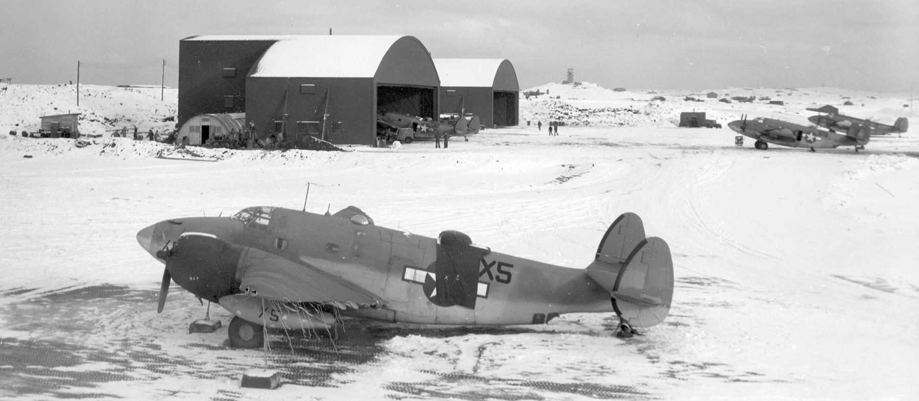
A September 1967 photo by 7th MAS Lodemaster Alan Young of Amchitka's Passenger/Cargo Terminal.
The AEC withdrew from Amchitka in 1973 & their facilities were abandoned.
A sign for Amchitka Airport & an adjacent aircraft propeller relic was placed near the Amchitka air terminal by Jim Coffey,
who recalled, “We were stationed on Amchitka with the Aleutian Island National Wildlife Refuge. I was the Maintenance Engineer there from 1975-78.
At that time there was a population of 6 on the island year round & my family made up 3 of the 6.
We were the first inhabitances to reoccupy the island after the AEC abandoned the site.”
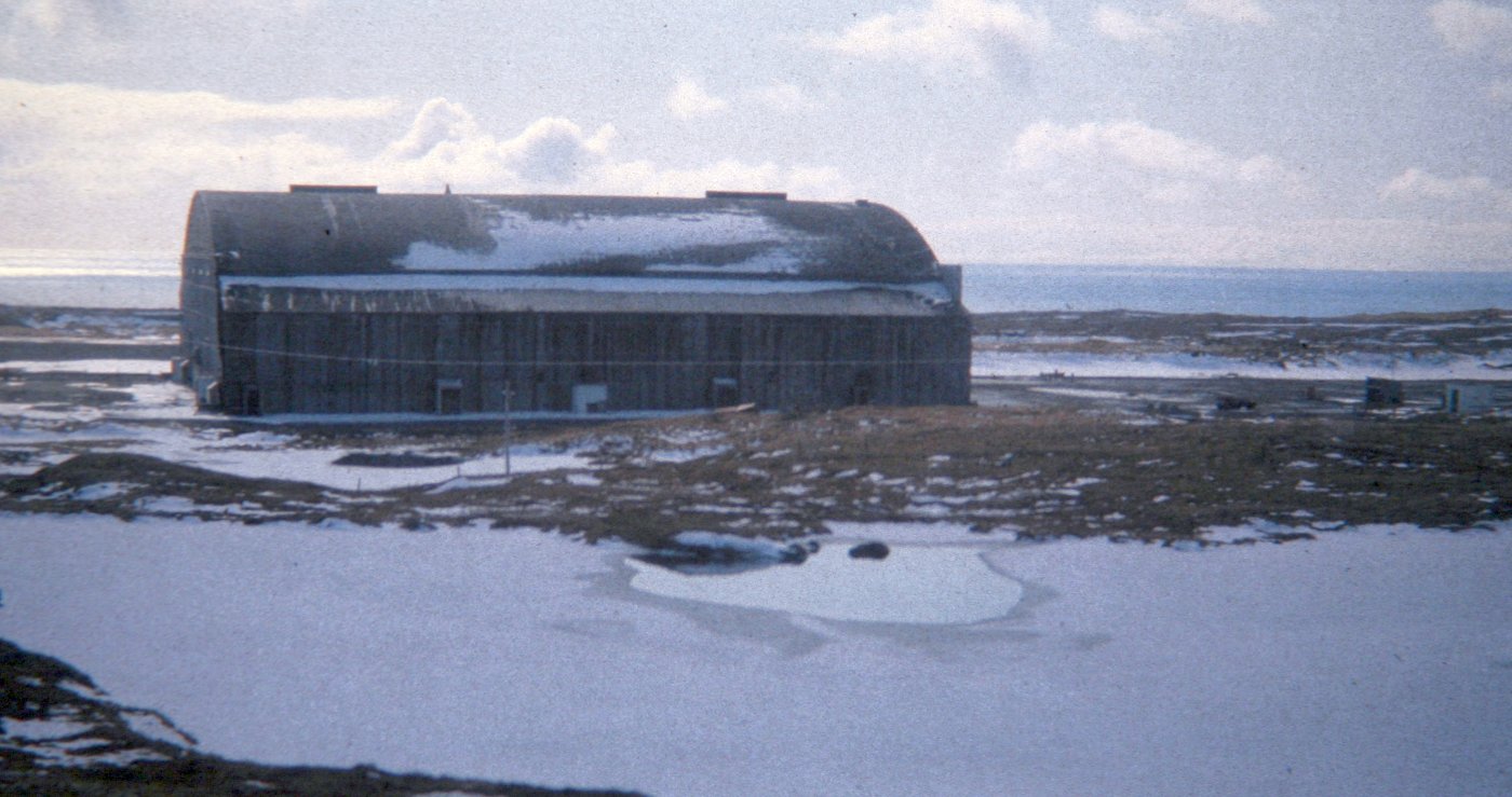
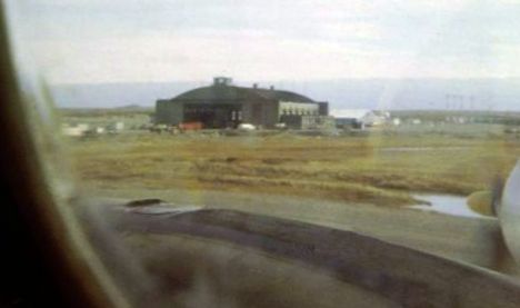
A 1979 photo of Amchitka's South Hangar, located on the south side of the main east/west runway.
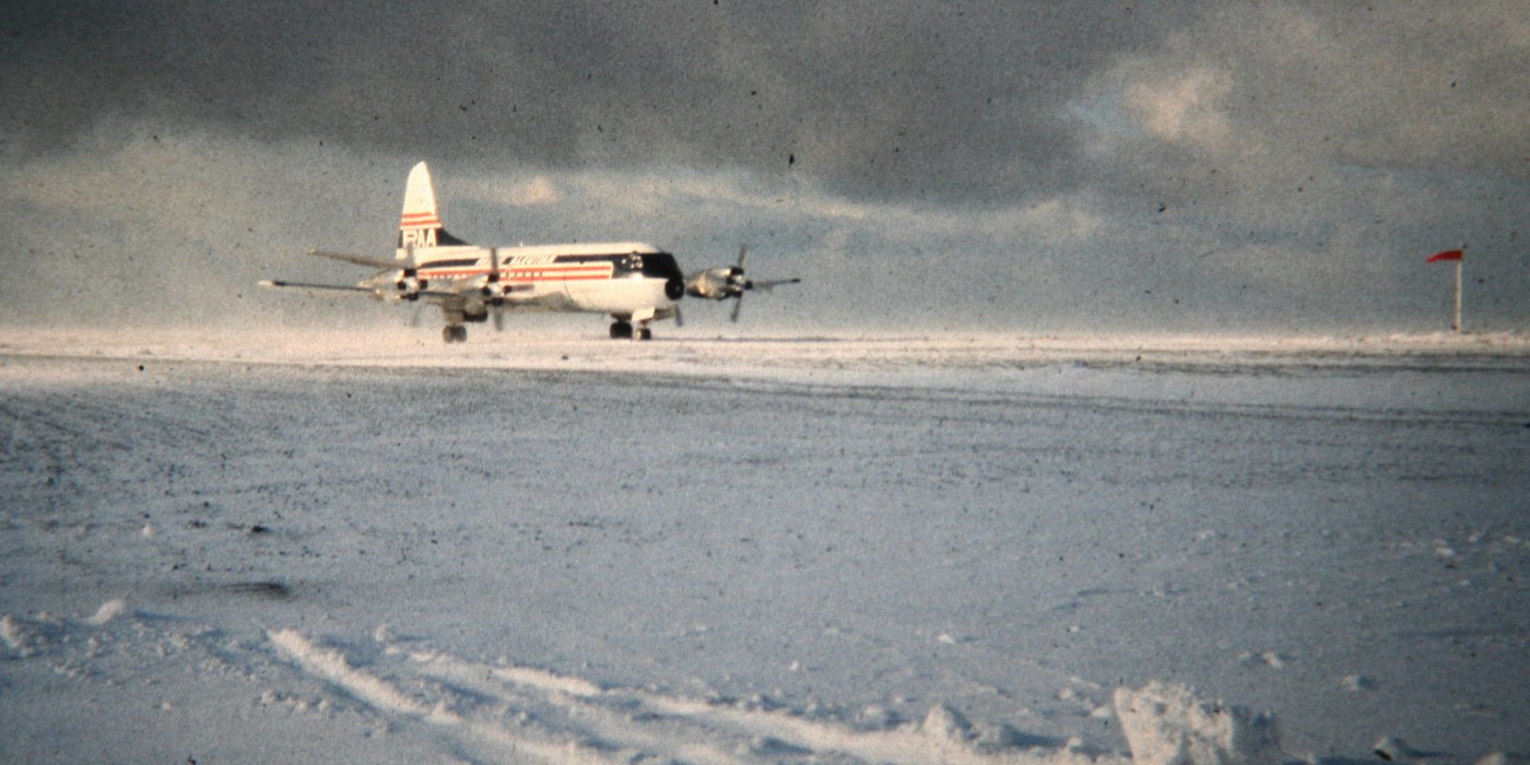
The last photo which has been located of an aircraft ay Amchitka was a 1979 photo of a Reeve Aleutian Airlines Lockheed Electra.
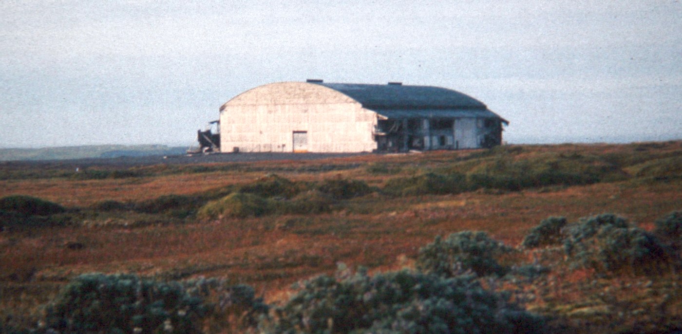
A 1979 photo of Amchitka's North Hangar, located on the north side of the main east/west runway.
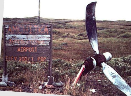
A 1980s photo by D. Hutchinson of the sign for Amchitka Airport & an adjacent aircraft propeller relic, located near the air terminal.
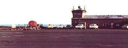
A 1980s photo by D. Hutchinson of the Amchitka Air Terminal showing a control tower cab on top of a hangar.
Note the airport sign & propeller (shown in preceding photo), visible to the left of the red fuel tank.
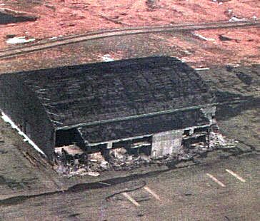
A 1980s aerial view of Amchitka's North hangar, which has since been demolished.
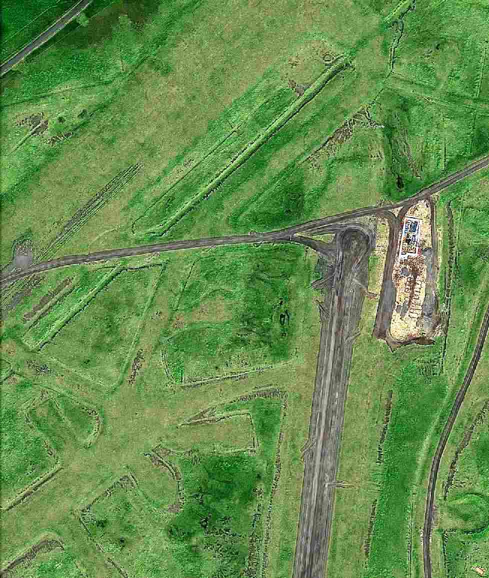
A 1/19/07 aerial view of the remains of the 3 Amchitka AAF/AFB runways, preserved under the snow.
A 1/19/07 aerial view looking northwest at the remains of the Amchitka AEC runway, preserved under the snow.
As of 2015, Amchitka Air Force Base is largely intact, although abandoned in most part for the past 60 years.
Runways, taxiways, aircraft parking dispersal revetments remain along with a large support base with deteriorating buildings.
Due to its remote location, it rests undisturbed with ice & snow covering the base most of the year, exposed to the elements in the short summers.
It is almost constantly under a cloud cover & fog generally obscures the area.
The remnants of the Amchitka AEC facilities are visible over a wide area, generally north of the former AFB.
The Department of Energy continues to monitor the site as part of their remediation program.
This is expected to continue until 2025, after which the site is intended to become a restricted-access wildlife preserve.
Thanks to Bill Grasha for pointing out this airfield.
____________________________________________________
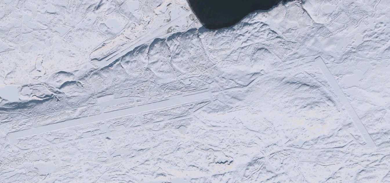
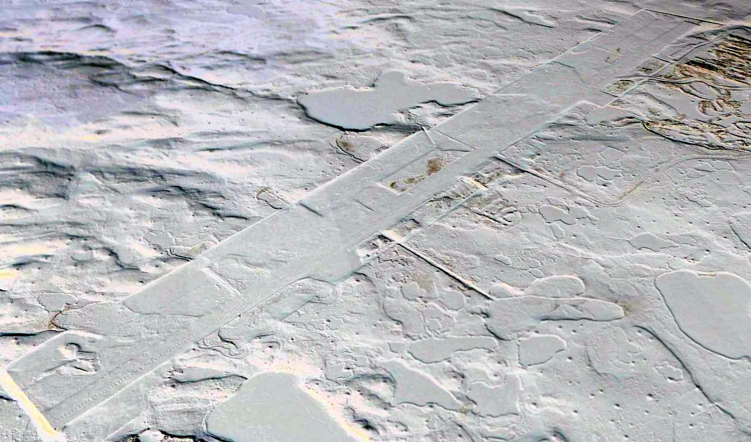
Western Shemya Army Airfield, Shemya Island, AK
52.72, -174.08 (Southwest of Anchorage, AK)
A 1944 aerial view depicted one north/south runway on the western end of Shemya, in addition to the primary airfield on the eastern end.
Shemya Island is one of the western-most American islands of the Aluetian Island chain, being located closer to mainland Russia (438 NM) than mainland Alaska.
On 5/28/43, a small detachment of Alaskan Scouts began reconnaissance of Shemya.
The following day, United States Army Engineers came ashore to begin construction of a runway suitable for B-29 Superfortress bombers.
Tents were erected, a rudimentary electrical system, radios and some rough streets were laid down.
A 10,000' east/west runway was constructed on the eastern portion of the island, along with a 5,000' north/south runway on the western portion.
A wide variety of aircraft flew from Shemya during WW2, but it is presumed the majority of these operated from the primary airfield on the eastern end of the island.
It is not known what specific purpose the western airfield served,
other than presumably serving smaller aircraft (fighters), leaving bombers to the larger airfield on the east end of the island.
With the exception of a small station housekeeping unit, Shemya was abandoned after WW2.
The island was littered with abandoned Army & Navy aircraft wrecks & deteriorating station structures.
Abandoned vehicles, warehouse stores of all types, rations, clothing & all the other tools of war, including ammunition & bombs were simply left out to the elements.
For a time the Air Force considered transferring the island to the Civil Aeronautics Administration.
However, the Air Force decided to retain Shemya because its location provided an ideal refueling stop on the Great Circle Route from Japan to Washington State.
The earliest depiction which has been located of the western Shemya airfield was a 1944 aerial view,
which depicted one north/south runway on the western part of the island, along with the much longer east/west runway on the eastern part of the island.
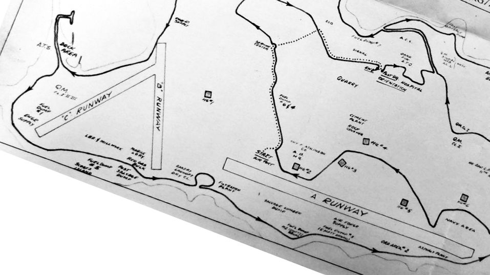
A circa 1945 map of the western end of Shemya (from the National Archives College Park, courtesy of Ron Plante)
depicted “B Runway” & “C Runway” on the western end, along with the much longer “A Runway” to the east.
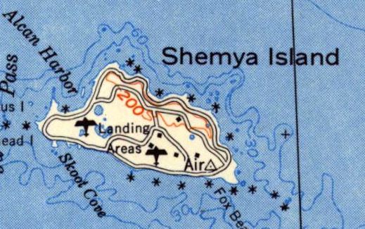
The 1952 USGS topo map simply depicted 2 “Landing Areas” on Shemya Island.
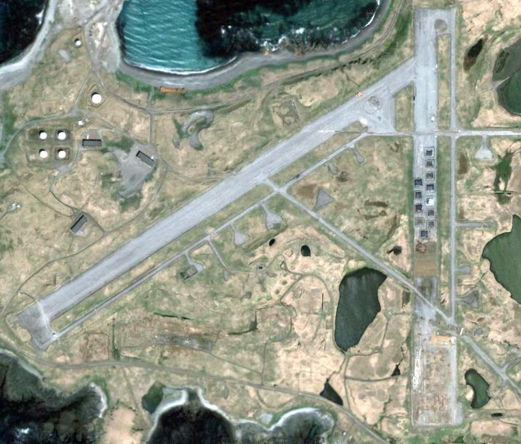
A 2006 aerial view showed the northeast/southwest runway on the west end of Shemya remained intact,
while the southern half of the north/south runway had been removed, and unidentified objects had been placed over the northern half.
____________________________________________________
Fort Randall Army Airfield Satellite Field, Cold Bay, AK
55.176, -162.646 (Northwest of Anchorage, AK)
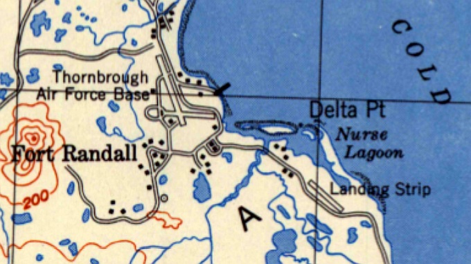
The 1949 USGS topo map depicted both Thornbrough AFB & its “Landing Strip” to the southeast.
Fort Randall Army Airfield was constructed during World War II during the secret military buildup of the Territory of Alaska that began in 1941.
Disguised as civilian employees of the Blair Canning & Packing Company, United States Army personnel in civilian clothes were shipped to Cold Bay.
Construction began in December 1941, and the airfield was ready for operation by March 1942.
The primary airfield had two 5,000' asphalt runways,
and 2 miles to the southeast was a separate satellite field with a single 5,000' gravel northwest/southeast runway.
It is not known what use (if any) the satellite airfield served.
Known units assigned to Fort Randall Army Airfield were:
1942-43: 73rd Bombardment Squadron, 1942-43: 344th Fighter Squadron,
June–July 1942: 54th Fighter Squadron, May–September 1942: 11th Fighter Squadron.
Fort Randall Army was redesignated to a Naval Auxiliary Air Facility on 4/1/43.
A 2-gun 152mm naval gun battery was located at Grant Point (one gun remains on display near the town dump).
A 4-gun 155mm gun battery on Panama mounts was located at Mortensen's Lagoon at Thin Point.
In the spring & summer of 1945, Cold Bay was the site of the largest & most ambitious transfer program of World War II,
Project Hula, in which the United States transferred 149 ships & craft to the Soviet Union
and trained 12,000 Soviet personnel in their operation in anticipation of the Soviet Union entering the war against Japan.
Fort Randall provided housing & classroom space for the instructors & trainees.
At any given time, about 1,500 American personnel were at Cold Bay & Fort Randall during Project Hula.
The installation at Cold Bay was renamed Thornbrough Air Force Base in 1948 for Captain George Thornbrough,
a U.S. Army Air Forces B-26 Marauder pilot.
Captain Thornbrough fought during the Battle of Dutch Harbor in June 1942,
bravely attacking a Japanese aircraft carrier that was launching strike aircraft at Dutch Harbor.
Although his torpedo struck the carrier, it failed to explode.
Captain Thornbrough returned to his airfield to refuel & rearm & then took off to rejoin the fight.
The aircraft & entire crew were lost during their return from this mission, when they were unable to land at Cold Bay.
The wreckage of Captain Thornbrough's aircraft was found 50 miles from Cold Bay on the north side of the Alaska Peninsula the following month.
The earliest depiction which has been located of the satellite field was on the 1949 USGS topo map,
which depicted a single northwest/southeast “Landing Strip” to the southeast of Thornbrough AFB.
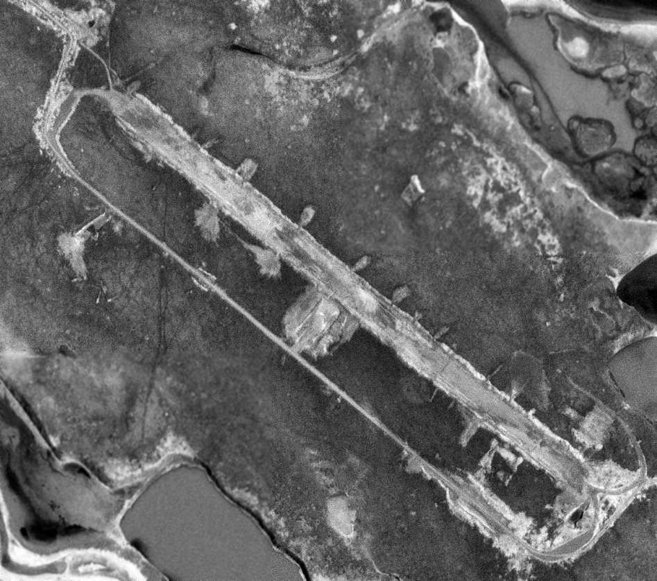
The earliest photo which has been located of the Cold Bay satellite field was a 6/22/73 USGS aerial view.
It depicted a single northwest/southeast runway, heavily deteriorated, with the remains of numerous dispersal parking pads on both sides of the runway.
A 2/27/11 aerial view looking northwest showed the Fort Randall Satellite Field remained recognizable but quite deteriorated,
with many of the dispersal pads no longer evident.
____________________________________________________
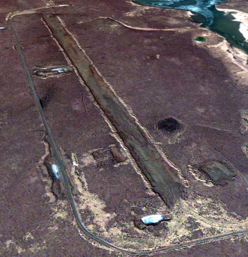
Eightmile Lake Airfield, Eightmile Lake AK
61.843, -151.11 (Northwest of Anchorage, AK)
Eightmile Lake Airfield, as depicted on an undated (pre-2011) USGS topo map (courtesy of Mark Hess).
Accordng to Kenneth Rivard, “This airstrip was built for oil exploration in the 1970s, specifically to land [a] C-130 with drill equipment.
I believe it was Alaska International.
I have been on that strip several times in my PA-18”
It consists of a mile-long (5,300') paved runway, with a paved parking ramp on the southeast side,
without any buildings or other improvements.
It sits in an extremely remote area, devoid of any towns or other settlement.
Was this airfield constructed by the military, or for mining support, or some other purpose?
The earliest depiction which has been located of the Eightmile Lake Airfield was an undated (pre-2011) USGS topo map (courtesy of Mark Hess),
which depicted a single northeast/southwest runway, with a ramp on the south side.
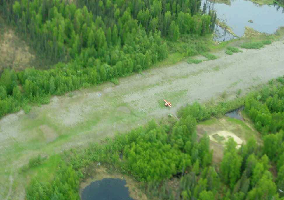
An undated (pre-2011) aerial view (courtesy of Mark Hess) depicted a single light aircraft on the Eightmile Lake runway.
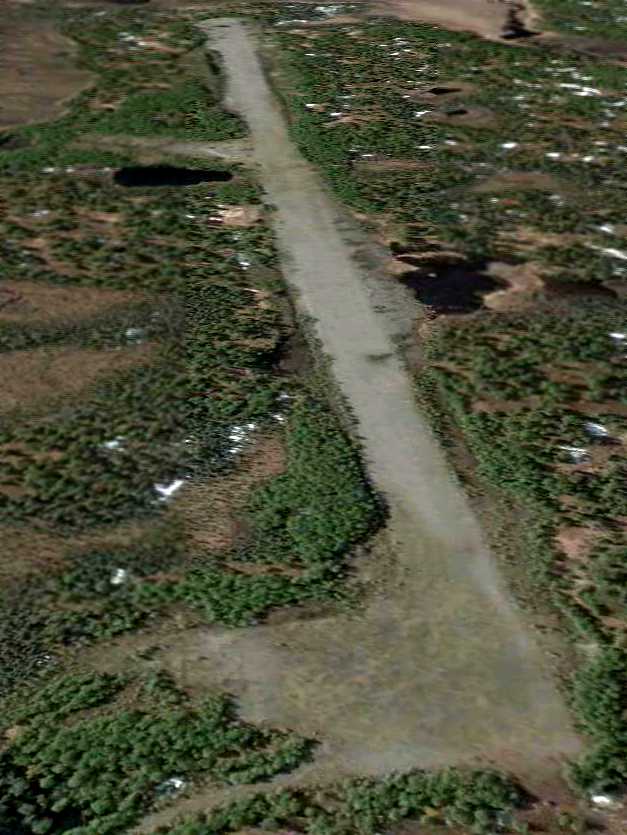
The only dated photo which has been located of the Eightmile Lake Airfield was a May 2011 aerial view looking southwest along the Eighmile Lake runway.
The 2011 Anchorage Sectional Chart depicted the Eighmile Lake Airfield as an “Unverified” airfield.
____________________________________________________
Original Bethel Airport, Bethel AK
60.78, -161.78 (Southwest of Anchorage, AK)
A 1939 aerial view looking east at the original Bethel Airport (from the Nerby family, courtesy of Jojo Prince).
The original location for the airport for the town of Bethel was located adjacent to the west side of the town,
along the northwest bank of the Kuskowim River.
The date of construction of the original Bethel Airport has not been determined.
The earliest depiction of the original Bethel Airport which has been located was a 1939 aerial view.
It depicted the field as having 2 unpaved runways on the northwest shore of the river.
By 1941 the original Bethel Airport was being replaced by a newly-constructed field on the opposite (southeast) bank of the river.
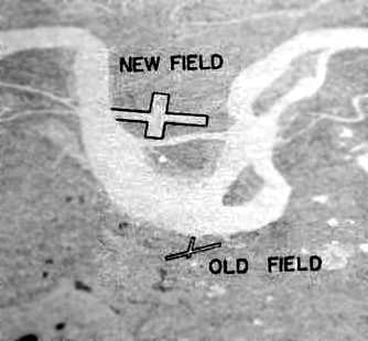
An undated aerial view looking southeast at the original Bethel Airport location (labeled “Old Field”) from a 1943 USAAF Air Route Manual (courtesy of Chris Kennedy).
It depicted the “Old Field” on the northwest bank of the river, with 2 small runways,
as well as the much larger “New Field” on the opposite bank of the river.
The manual said that the “Old field across the river is being abandoned.”
An undated (circa 1940s?) aerial view looking east at the original Bethel Airport (from the Nerby family, courtesy of Jojo Prince).
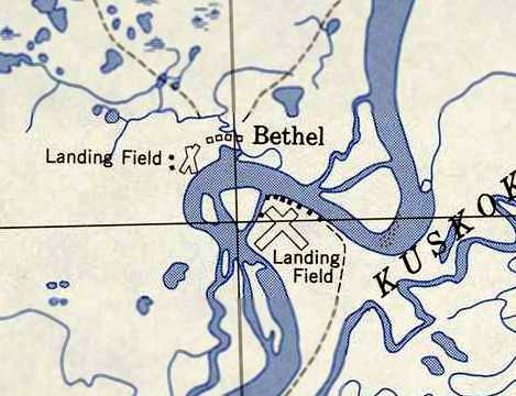
The 1950 USGS topo map (courtesy of Chris Kennedy) depicted the original Bethel Airport location on the west side of the river (labeled “Landing Field”)
as having 2 runways with 2 small buildings on the west side.
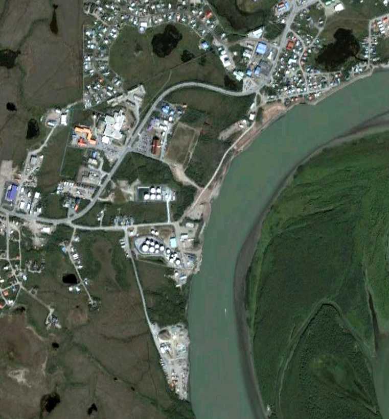
A 8/13/05 aerial view no longer depicted any trace of the original Bethel Airport.
Ironically, the present-day Bethel Airport (the 3rd location of the field) is located only one mile to the west.
____________________________________________________
Bethel Airport (2nd location), Bethel AK
60.775, -161.727 (Southwest of Anchorage, AK)
An undated aerial view looking southeast at the 2nd location of the Bethel Airport (labeled “New Field”)
from a 1943 USAAF Air Route Manual (courtesy of Chris Kennedy).
The second location for the airport for the town of Bethel was located on the southeast bank of the Kuskowim River.
Construction of a runway at this site reportedly began in 1941,
replacing the much-shorter runways of the original airport adjacent to the town.
The earliest depiction of the 2nd location of Bethel Airport which has been located
was an undated aerial view from the 2/20/43 USAAF Air Route Manual (courtesy of Chris Kennedy).
It depicted the “New Field” on the southeast bank of the river, with 2 perpendicular runways,
much larger than the runways of the “Old Field” on the opposite bank of the river.
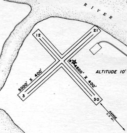
The 2/20/43 USAAF Air Route Manual (courtesy of Chris Kennedy) depicted “Bethel Airfield”
as having 2 asphalt runways: 5,000' Runway 3/21 & 4,500' Runway 12/30.
The field was said to not have any hangars,
but a single small building was depicted just east of the runway intersection.
The field was said to be served by PAA, Star Airways, Peterson Air Service, Woodley Airways, and Peck & Rice Airways.
Bethel was described as being operated by the Civil Aeronautics Administration.
The 1950 USGS topo map (courtesy of Chris Kennedy) depicted the 2nd location of Bethel Airport on the southeast side of the river (labeled “Landing Field”)
as having 2 runways with several small buildings along the west & north sides.
In 1951, control of the Bethel Airport site, plus another 300 acres along Napaskiak Slough, reverted to the USAF.
From 1951-53 the 30th Eng Bn (topo) used 32 acres as a campsite while mapping the area.
In 1954 the 660th Eng Bn used 3 acres for the same purpose.
Neither made any permanent improvements, and the site was abandoned by the DoD in 1954.
The FAA maintained the Bethel Airport site starting in 1955.
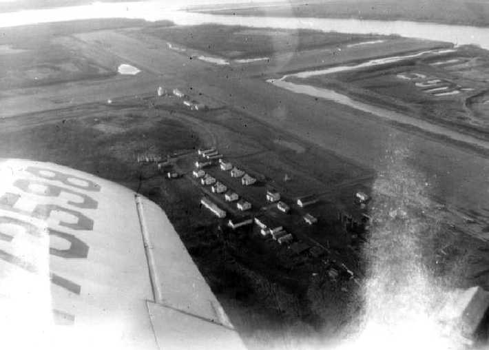
A mid 1957 aerial view by LeRoy German of Bethel Airport, which LeRoy recalled was taken “with a Kodak Brownie Haweye box camera.
The houses were for civilian CAA employees & their families. I am not sure what they were doing there.
I was a one-stripe E-2 radio maintenance man in the Air Force while I was there.
The 5-man Detachment 2, 10th Radio Relay Squadron site there is obscured by the photo smudge.
The relay site was being re-located to Tern Mountain, 100 miles west on the coast to improve radio propagation between Cape Romanzoff & Cape Newenham radar sites.
I spent the last 7 months of my tour at the 2-man Tern Mountain site.
The new airport & the 713th AC&W radar site were under construction northwest of Bethel at this time.
We would cross the river to Bethel on the ice in winter, and by boat in summer.”
By 1957, another Bethel Airport was operating in a 3rd location, one mile to the west.
The 1957 USGS topo map depicted the clearings for the 2 runways at the site of the 2nd location of the Bethel Airport,
but it was unlabeled.
The FAA maintained the property of the 2nd Bethel Airport site until 1959,
after which the it was utilized by residents for their fish camps.
In 1998, a contract was awarded to remove drums of tar that had been eroding into the Kuskokwim River from the Bethel Airport site.
A 8/13/05 aerial showed the very recognizable outline of the perpendicular runways at the site of the 2nd location of Bethel Airport,
with pavement appearing to remain somewhat intact along the former Runway 3/21.
LeRoy German recalled, “I returned there in July 2010 & all that remained was part of the asphalt runway for emergencies.”
____________________________________________________
Fort Glenn Army Airfield / Otter Point Naval Air Facility, Umnak Island, AK
53.375, -167.895 (Southwest of Anchorage, AK)
An undated aerial view looking west at Ft. Glenn AAF (from a February 20, 1943 USAAF Air Route Manual, courtesy of Chris Kennedy).
The Ft. Glenn site was acquired in 1942, according to an Army Corps of Engineers FUDS report (courtesy of Chris Kennedy).
It was located on Umnak Island at Umnak Pass, the narrow body of water separating Umnak & Unalaska islands.
The 102,062-acre site was improved with Quonset huts, buildings, ammunition magazines, hangars, and 4 paved runways.
Blythe Block recalled, “My father, Stan Block, was with the Army Corp of Engineers & helped build the original airfield.
My father was on the detail which brought the Marsden Mats to the first runway.
If you look at the geography of the island, you might wonder how they got the Marsden Mats up the bluffs to the plateau of the island, so that the first runway could be built.
My father & others rigged a 'mule', some kind of diesel engine, and used it to haul each of the heavy steel mats up the bluff, in order to build the first runway.
Because of the presence of that runway, our fighters were able to repel the first Japanese attacks at Dutch Harbor.
My father & mother hosted some of the PBY pilots stationed near Yakutat Bay, pilots who later died defending our country.”
Charles Donovan recalled, “In May 1942 through December 1944 I was stationed at Chernofski Bay & USNAAS Otter Point, Umnak.
Six of us US Navy radiomen were sent there to set up weather reporting stations.
I was at Otter Point when they were installing the Marsden matting to make it.
I saw the first P-40s, P-38s and B-24s use it.”
George Jones reported, “I was watching the Discovery Military Channel [2005].
They were showing a documentary that covered WWII in Alaska - the Aleutian Island Campaign in particular.
The program pointed out that during the initial build up of Alaskan defenses,
a secret airfield (reportedly disguised as a cannery) was built on the Eastern end of Umnak Island.
Fighters launched from that base (which was later to be called Fort Glenn) were successful in turning back the first Japanese attack on Dutch Harbor -
the Japanese had sent in their bombers without fighter escort.
The whole idea of a secret airbase that, apparently, even the Army brass didn't know about, fascinated me.
It sounded like something right out of a Blackhawk Squadron comic book.”
The Navy's facility, Otter Point Naval Air Facility, was adjacent to the Army Airfield.
According to a Navy report (courtesy of Chris Kennedy),
“Construction was carried out entirely by Seabees & the Army.
The development of the facility at Otter Point was approved by the Secretary of the Navy on September 18, 1942,
and Commanding General Alaska Defense Command assigned the required land on September 25, 1942.
The work was done by a detachment of the 8th Construction Battalion.”
The Navy report continued, “Housing & messing facilities for 119 officers & 359 men were constructed,
as well as recreational & ship's service buildings.
Storage facilities consisted of 6,975 square feet for general stores & a 150-cubic-foot freezer.
Buildings for aircraft included a kodiak-type hangar, 160' x 90', a squadron warehouse, and a terminal for air transport service.
Administration offices were housed in 5 buildings with a total floor space of 3,850 square feet.
Radio facilities included a transmitting station, a direction-finder station, and a radar station,
all with separate power houses & with housing & messing provisions for personnel.
The hospital, located in one small building, contained 8 beds.”
The Navy report continued, “The maintenance force of the station was installed in 7 buildings.
Electric power was provided by 3 diesel-electric generators.
All other utilities were furnished by the Army at Fort Glenn, which also provided landing strips & revetments,
aviation gasoline & fuels of other types, provisions, and repair facilities for aircraft.”
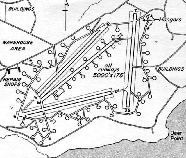
A February 20, 1943 USAAF Air Route Manual (courtesy of Chris Kennedy)
depicted Ft. Glenn AAF as having an unusual airfield layout,
with 4 paved 5,000' runways, two of which were situated only 10 degrees apart.
Runway 4/22 was described as consisting of steel mat, while the other 3 were said to be under construction.
A network of taxiways ringed the runways, along which were sited no less than 60 individual aircraft dispersal pads.
Three hangars were depicted on the northeast corner of the field,
and repair shops were depicted on the west side.
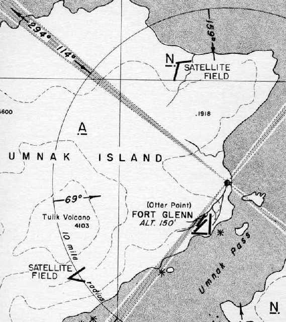
An approach plate for Ft. Glenn AAF from the February 20, 1943 USAAF Air Route Manual (courtesy of Chris Kennedy)
depicted Ft. Glenn's 2 satellite fields, #1 located 9 miles north-northwest & #2 located 7 miles southwest.
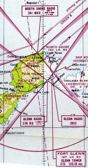
The earliest aeronautical chart depiction which has been located of Ft Glenn AAF
was on the January 1947 World Aeronautical Chart (courtesy of David Brooks).
It depicted Ft. Glenn AAF as having a 8,300' paved runway, and a control tower.
Its 2 satellite airfields were also depicted (North Shore & Pacifier).
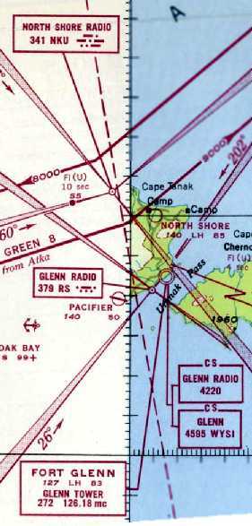
The last aeronautical chart depiction which has been located of Ft Glenn AAF
was on th February 1947 World Aeronautical Chart (courtesy of David Brooks).
It depicted Ft. Glenn AAF as having a 8,300' paved runway, and a control tower.
Its 2 satellite airfields were also depicted (North Shore & Pacifier).
The Ft. Glenn site was excessed between 1952-55 to the Bureau of Land Management
and later transferred to numerous owners (Native corporations & the State of Alaska),
according to an Army Corps of Engineers FUDS report (courtesy of Chris Kennedy).
No airfield at Ft. Glenn was depicted on the April 1988 Dutch Harbor World Aeronautical Chart (according to Chris Kennedy).
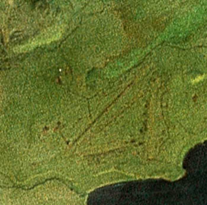
As seen in a circa 2005 aerial photo,
the outlines of the former runways of Ft. Glenn were still barely perceptible,
more than 50 years after the field was abandoned.
Marc Hookerman recalled of the Ft. Glenn Airfield, “I was out there in 2005 on a freight contract,
and we graded one of the old runways so it would be usable for larger aircraft.”
A 2008 aerial view looking south at Ft Glenn Airfield by Dirk Bowen.
Dirk reported, “I went to Fort Glenn today on a medevac.
It's not in the Alaska supplement, although it is still in occasional use.
There is a cattle ranch there now, most of the work including herding is done with R-22s, but 2 runways are still usable.”
A 2008 photo by Dirk Bowen of the King Air 200 he landed at the Ft Glenn Airfield.
Dirt observed, “It was very soft (I also have a shot of the wheels & the tracks we were leaving, about 3/4 inch deep).
We didn't want to turn around because the runway is narrow & most likely softer on the edges,
so we stopped as short as we could & took off from there.”
A 6/16/11 photo by Steve of a Cessna 441 at the Ft Glenn Airfield.
Steve reported, “The feds have put out contracts for hazardous waste cleanup at all the WWII sites in Alaska.
I fly for a charter company & we had the contract to support the cleanup crew at Ft. Glenn.
They found chemical bombs. For the last year & a half the various federal agencies have been shuffling paperwork to get permits, etc. to clean it up.”
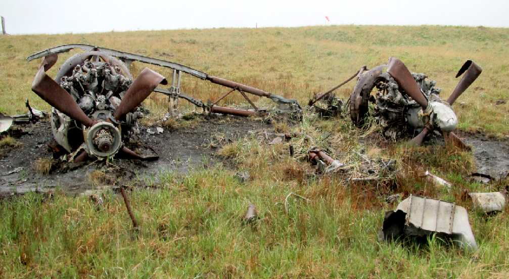
A 6/16/11 photo by Steve of the remains of a Northrop P-61 Black Widow night fighter at the Ft Glenn Airfield (note the windsock in the background).
A 6/16/11 photo by Steve (enhanced by Bill Grasha) of 2 Quonset huts at Ft Glenn, one of which is earthen covered.
Steve reported, “Ft. Glenn was huge, covering many square miles. They laid in underground water pipes & ran phone lines all over.
Some of the Quonset huts are 10 miles or more from the runways.”
A September 2011 satellite picture of the northeastern portion of a runway & other remains at Ft. Glenn (courtesy of Lars Gleitsmann).
____________________________________________________
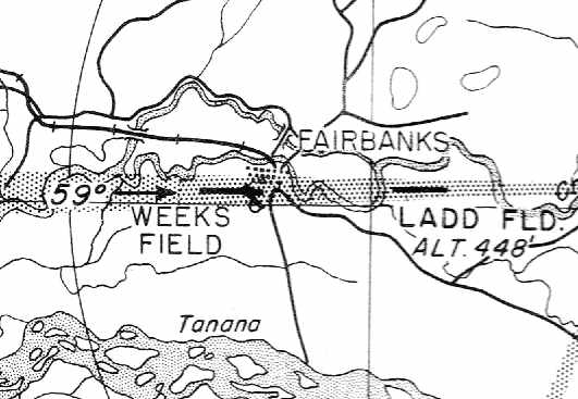
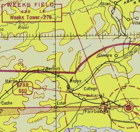
64.838, -147.73 (Northeast of Fairbanks International Airport, AK)
The earliest photo which has been located of a plane at the location which eventually became Weeks Field
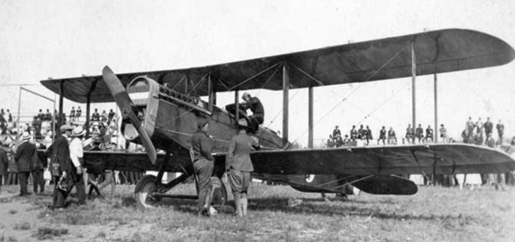
was a 1920 photo of spectators viewing a de Havilland DH.4 biplane from the Black Wolf Squadron.
They were pictured at the old Fairbanks baseball park which would eventually become the location of Weeks Field.
According to the website of the current Fairbanks International Airport,
aviation service in the Fairbanks area was initiated at Weeks Field (also known as Weeks Ball Park) in 1923.
This multi-use facility gained importance in the community & throughout the Alaska aviation system
from the time that Carl Ben Eielson first flew into Fairbanks in 1923 to start Alaskan Airways.
A majority of Fairbanks's general aviation & commercial air traffic was eventually accommodated at Weeks Field through mid-century.
A 1924 photo of James Rodebaugh's first plane in his first hangar, in the old Fairbanks baseball park which later became Weeks Field.
This was the first commercial airplane in Fairbanks. Rodebaugh was sole owner having financed its purchase by himself.
A 1930 revision page of the 1929 Union Oil of California “Airplane Landing Fields of the Pacific West” (courtesy of Chris Kennedy)
described the Fairbanks “Territorial” Airport as being operated the the Alaska Road Commission.
The field was said to have two 2,000' runways(southeast/northwest & east/west), in an X configuration.
The field was said to offer hangars, fuel, and repairs.
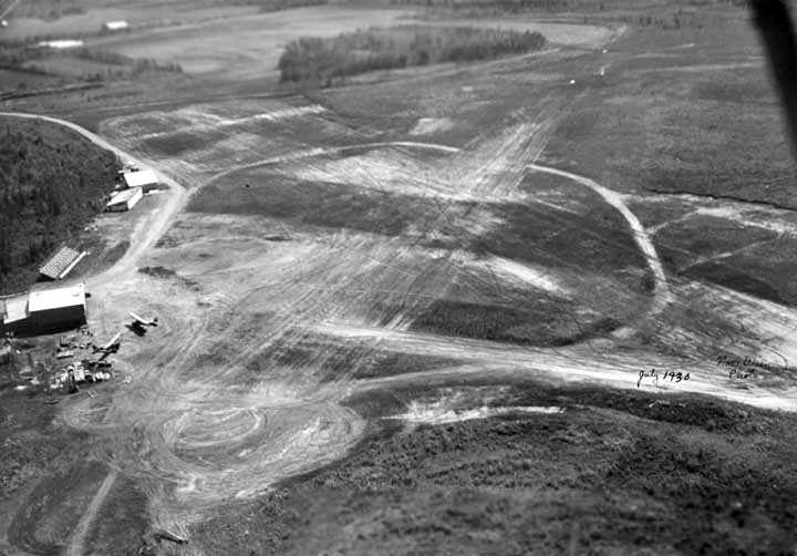
A July 1930 aerial of looking east at Weeks Field (from Alaska's Digital Archives, courtesy of Chris Kennedy).
Several hangars were visible on the north side of the field, along with 2 aircraft.
The field had several unpaved runways.
There is also what appeared to be a set of bleachers, in between the hangars.
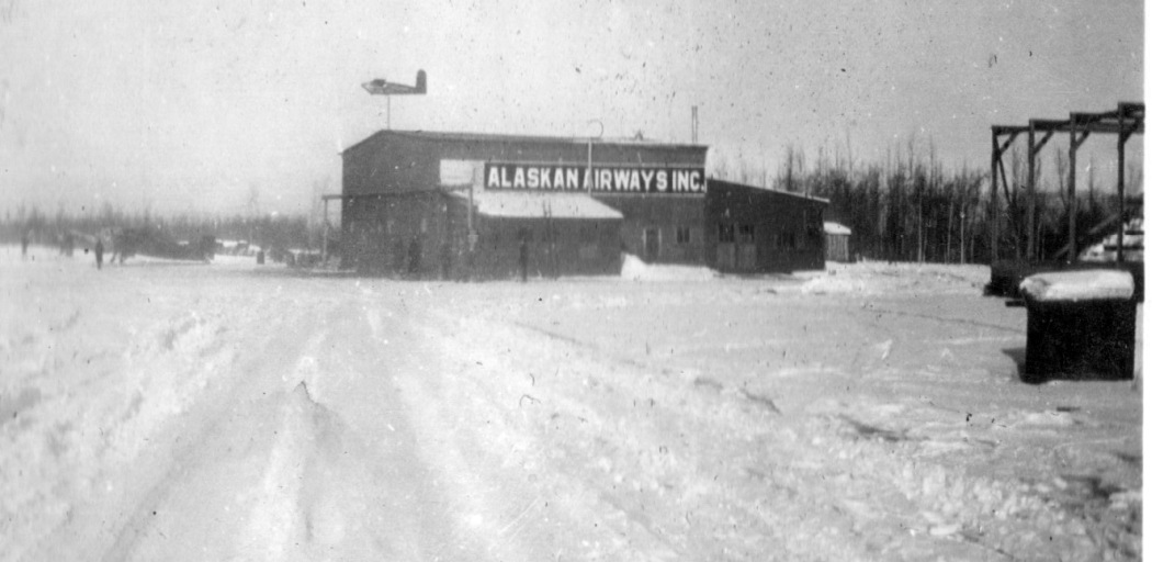
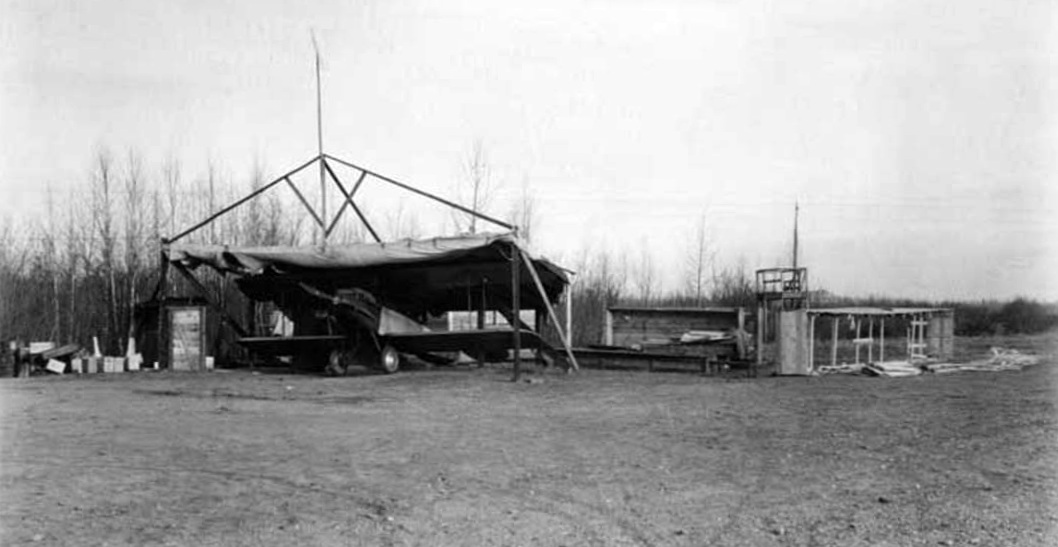
A circa 1931-32 photo by Harold Schober (courtesy of Todd Swain) of an “Alaska Airways Inc” hangar, presumably at Weeks Field.
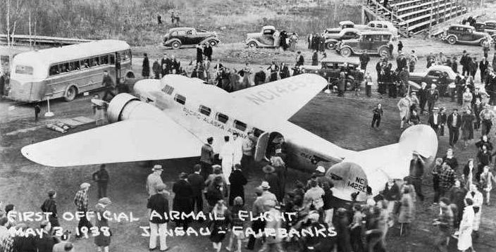
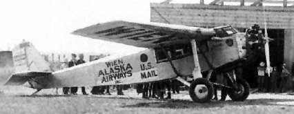
A 5/3/38 photo of Pacific Alaska Airways' Lockheed Electra at Weeks Field,
with a crowd surrounding it upon making the 1st official airmail flight from Juneau to Fairbanks.
According to John Ragle, in 1940 flight instructor Richard Ragle occupied a site on Weeks Field.
The field consisted of a gravel strip (during the summers) running from Gillam Way & ending in the town dump.
The first site occupied by Ragle was at the east end of the runway, off Gillam Way,
and the second was about midway along the north edge of the runway at the end of a skid road bulldozed through the brush.
In the latter, the installation consisted of a couple of "wanigans" on skids,
one of which was arranged so that the nose or engine nacelle of a plane
could be brought inside for the necessary, frequent, maintenance required by propeller-driven planes.
The other wanigan was used for ground-school operations.
The Ragle flying school & air service on Weeks Field continued during 1940 and early 1941
with a Federal Grant through the University of Alaska for pilot training,
and some 50 pilots graduated via this effort.
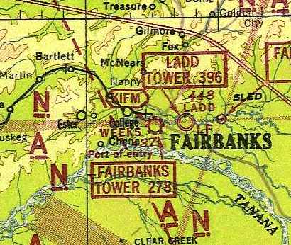
The earliest chart depiction of Weeks Field which has been located
was on the June 1942 Fairbanks Sectional Chart (courtesy of Chris Kennedy).
It depicted Weeks as a commercial/municipal airport.
The Ragle flying school at Weeks Field had ceased operations by 1943 or 1944.
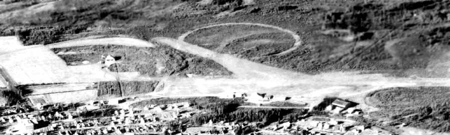
An undated (circa 1940s?) aerial view looking south toward Weeks Field from a postcard (courtesy of Chris Kennedy)
depicted Weeks Field as having several hangars & unpaved runways.
The runway configuration is different than that depicted in an earlier photo.
Also depicted was a large circular marking adjacent to one runway.
According to Pat Fitzgerald, “In one of the history books about Fairbanks it tells of the news of a large dirigible that was going to land in Fairbanks (I believe on it's way around the world.)
The ship needed room to turn around & people practiced for this maneuver.
Sadly the ship never came to town & I believe that circle was it's landing & turnaround area.”
The 1945 USAAF Pilot's Handbook (courtesy of Chris Kennedy)
depicted Weeks Field as having a single east/west runway.
The January 1946 Fairbanks Sectional (courtesy of Chris Kennedy)
depicted Weeks Field as having a commercial/municipal airport.
City growth surrounded Weeks Field in the 1940s,
leading to plans which coalesced in 1948 for development of a new airport to the southwest of Fairbanks,
which eventually became Fairbanks International Airport.
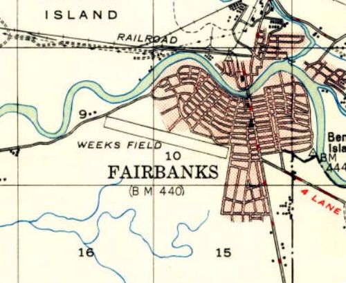
The 1949 USGS topo map depicted Weeks Field as having a single northwest/southeast runway.
The last photo which has been located of Weeks Field was an 8/8/49 USGS aerial view.
It depicted Weeks Field as having a single northwest/southeast runway,
with several planes visible around the east end of the field.
Mary recalled, “In the 1940s, 1950s, and 1960s my family lived in the old Weeks Field Restaurant; my parents turned it into our home.
It was located at 826 Smythe Street, Fairbanks, on the corner of Cowles Street & Smythe Street.”
The Weeks Field control tower was decommissioned on 6/1/51 (according to the Fairbanks FSS website),
and flight operations were shifted from Weeks Field to the new airport in 1951.
Not long after the field closed, the abandoned Weeks Field control tower burned down on 10/18/51.
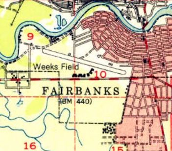
A 9/12/51 USGS aerial photo shows buildings being constructed adjacent to both sides of the Weeks Field runway.
The last map depiction which has been located of Weeks Field was on the 1952 USGS topo map.
It depicted Weeks Field as having a single northwest/southeast runway, with a row of buildings to the south.
The 1955 USGS topo map depicted several streets covering the site of Weeks Field.
Mary recalled, “After many years my mother had it [the former Weeks Field Restaurant] burned down to sell the property.
Much to my dismay; as I would love to have it for historical reasons.”
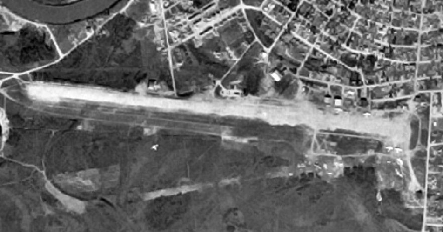
A 6/14/67 USGS aerial photo no longer showed any trace of the Weeks Field runway.
At some point the site of Weeks Field was reused as Weeks Field Park.
As seen in the 1998 USGS aerial photo,
Weeks Field Park occupies a portion of the former airport property.
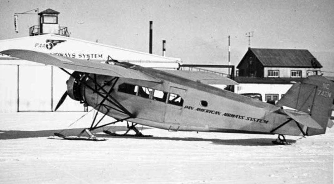
The large building northwest of the center of the photo is reportedly the old Pan-Am hangar, now a bowling alley.
It appears to match a building depicted in the aerial photo several paragraphs above.
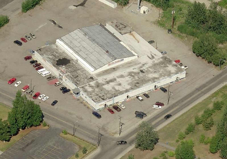
A circa 2010 aerial view looking north at which appears to be the former Weeks Field Pan-Am hangar, surrounded on 3 sides by modern additions,
and reused as the Arctic Bowl bowling alley.
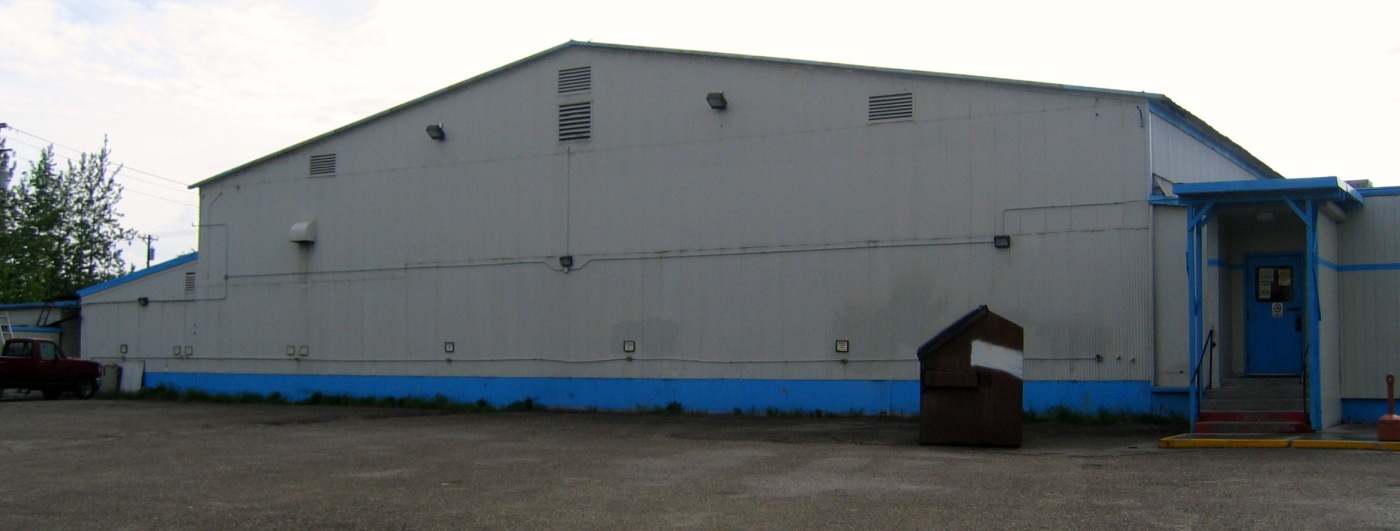
A 9/11/08 photo of the former Weeks Field Pan-Am hangar,
The site of Weeks Field is located northeast of the intersection of Cowles Road & Airport Way.
____________________________________________________
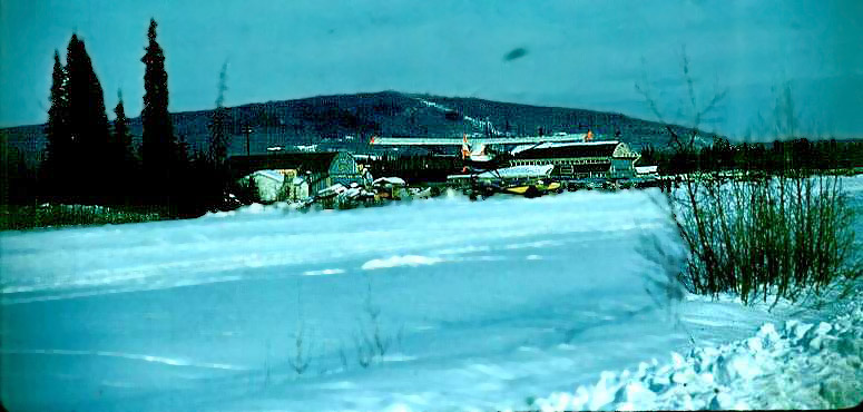
64.85, -147.793 (Northeast of Fairbanks International Airport, AK)
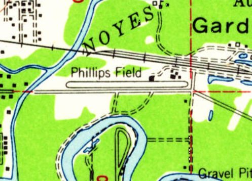
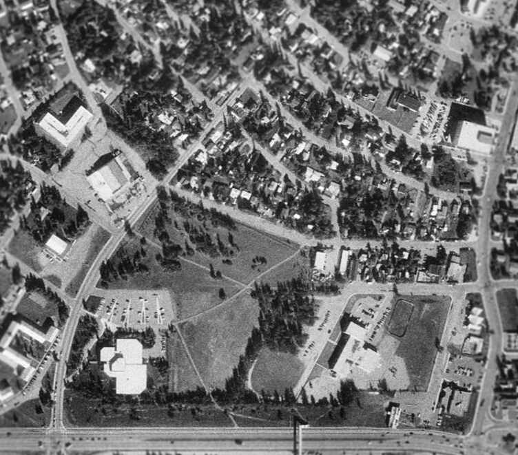
Phillips Field, as depicted on the 1955 USGS topo map.
Phillips Field may have been established at some point between 1952-53,
as it was not yet depicted on a 9/12/51 USGS aerial photo nor on the 1952 USGS topo map.
The earliest reference which has been located to Phillips Field came from Tom Slaney,
who recalled, “ I took my first flying lesson 7/4/53 at Phillips Field.”
The earliest depiction which has been located of Phillips Field was on the 1955 USGS topo map,
which depicted Phillips as having a single east/west runway.
Dave Menard recalled, “In the spring of 1957, I walked out to Phillips Field to see if there were any aircraft of interest.
There was one, the steel frame remains of a Fairchild Pilgrim, which had been burned by the local fire brigade as a training event (sob!).”
The earliest photo which has been located of Phillips Field was a circa 1959 photo (enhanced by Bill Grasha)
looking northeast at a ski-equipped Cub landing at Phillips Field, with 2 hangars in the background.
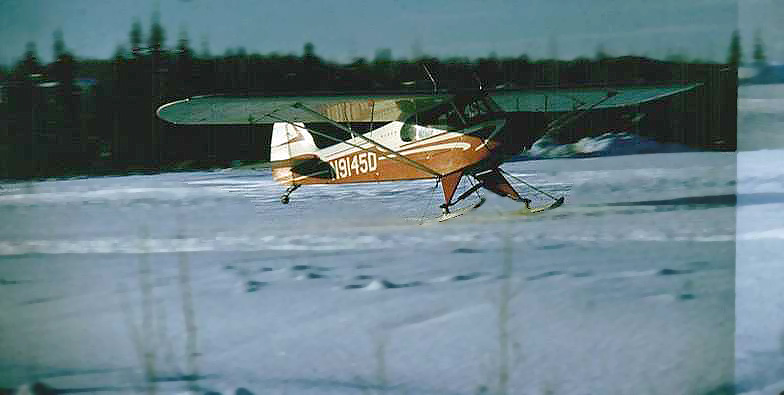
A circa 1959 photo (enhanced by Bill Grasha) of a ski-equipped Cub landing at Phillips Field.
The last photo which has been located showing Phillips Field was a 6/14/67 USGS aerial view.
It depicted Phillips as having a single paved east/west runway, with several buildings & a large quantity of light aircraft on the northeast side.
The 1975 USGS topo map depicted Phillips Field as having a single paved east/west runway,
with a few buildings on the northeast side.
The last depiction which has been located of Phillips Field was on the 1976 USGS topo map.
Bev Hormann recalled, “Phillips Field... I know that the airfield ran into 1971-72. My ex-husband flew out of the field in the fall of 1971 headed north to work.
I remember dropping him off in a brand new 1971 canary yellow Camaro we had borrowed at the small blue at the building next to the blue hangar (that still exists [as of 2013]).”
Greg Garrels recalled that “The hangar in the [northeast corner of Phillips Field] was the location of Bachner Aircraft Service.
It was run by Jess & Ann Bachner. Among other things they were a Piper dealer. I recall getting parts there when the airport was still open.
The motto on their receipts used to say, 'We have everything...Sometimes we can't find it.'”
Dave Critchfield reported, “In September 1989 it was still open the but shortly thereafter, it was closed to make room for the new freeway.”
Phillips Field was no longer depicted on the 1992 USGS topo map.
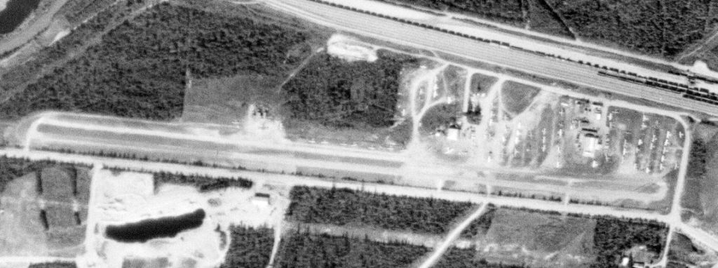
Phillips Field had been covered by the Johansen Expressway by the time of the 1998 USGS aerial view.
The expressway was built right over the runway, but at least 2 hangars remained standing on the northeast side.
It is not known if any of the buildings along the south side date to the property's days as an airport.
A circa 2006-2010 aerial view looking north showed a hangar remaining on the north side of the Phillips Field site.
A circa 2006-2010 aerial view looking north showed the former Bachner Aircraft Service hangar remaining on the northeast corner of the Phillips Field site.
A 6/2/09 aerial view showed that the 2 hangars remained standing on the northeast side of the Phillips Field site.
Dave Critchfield reported in 2010, “Some of the hangars are still there used by other businesses.”
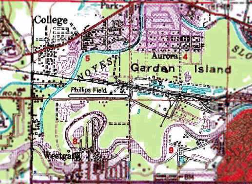
The site of Phillips Field is located east of the intersection of Johansen Expressway & Peger Road.
____________________________________________________
Miller Army Airfield, Cape Chiniak, AK
57.616, -152.194 (Southwest of Anchorage, AK)
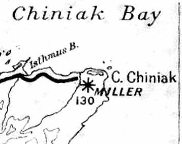
Miller Field, as depicted on a 1946 AK Road Commission Map (courtesy of Timothy Aanerud).
Miller Army Airfield was located on Kodiak Island.
It was evidently built during WW2 as a fighter landing strip,
to assist in any needed defense of Alaska.
The date of construction of Miller Field has not been determined.
It was not yet depicted on a February 1943 USAAF Air Route Manual of Alaska (according to Chris Kennedy).
The earliest depiction of Miller Field which has been located
was on a 1946 AK Road Commission Map (courtesy of Timothy Aanerud).
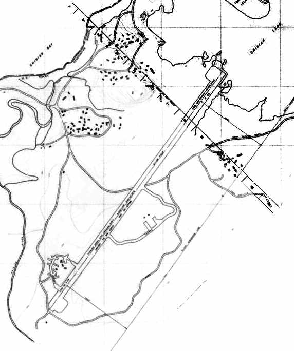
An undated topo map depicting the runway of Miller Field.
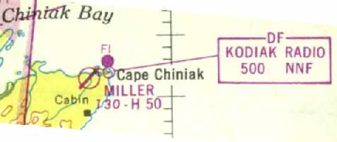
The January 1947 World Aeronautical Chart (courtesy of Timothy Aanerud)
depicted Miller as a civilian airfield, having a single 5,000' hard-surface northeast/southwest runway.
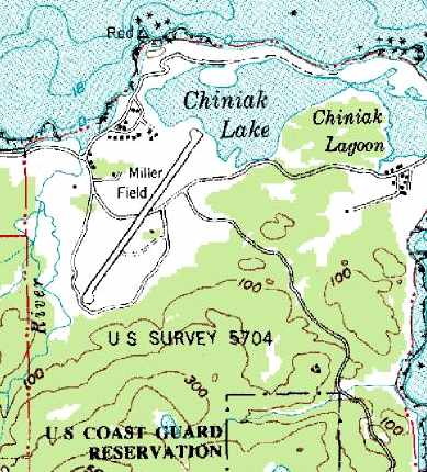
The 1949 USGS topo map depicted Miller as having a single northeast/southwest runway.
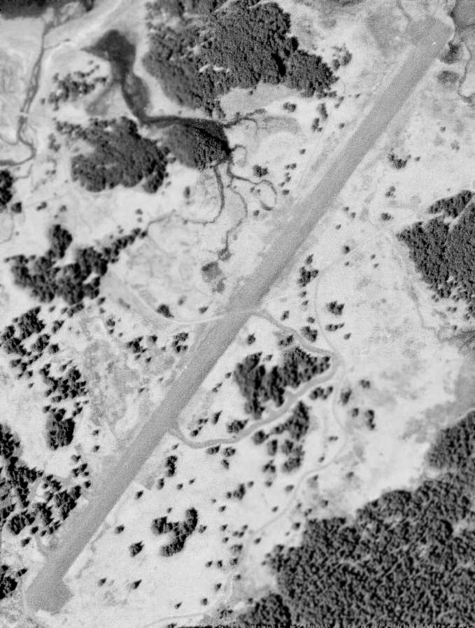
The only photo which has been located of Miller Field was a 6/1/52 USGS aerial view,
which depicted Miller as having a single northeast/southwest paved runway.
According to a book by Tony Smaker (via Timothy Aanerud),
in 1958 a C-124 managed to land at Miller Field,
but tore up good portion of the perforated steel plate which made up Miller's runway surface.
Karl Esch recalled, “My father was the XO of FASRON 114, NAS Kodiak in the late 1950s.
We had a quonset hut for a weekend cabin not far from Miller Field on Chiniak Point.
When our family trekked the 40 miles from the NAS to Chiniak for the weekend,
my father always took the family station wagon for a high speed run down Miller Field to 'blow out the carbon' and thrill his kids.
It was probably the fastest place you could drive, other than the NAS runways, on the entire island.”
Pete Azzole was at Miller Field in 1962. He recalled, "When I was there, Miller Field was merely steel matting.
I don't recall finding any structures or remnants thereof in the immediate vicinity of the field."
According to George Zonoff, “Miller Field was in active use during the period 1962-68
in support of the Air Force Kodiak Tracking Station.
During that period C-124s laden with cargo were able to land without difficulty
on the perforated metal strips despite the absence of air-to-ground communications.
In addition, technical support provided by C-54s landed as well,
although during landing it was clear the perforated landing was 'rolled up'
in front of the landing gear wheels & the aircraft rolled to a stop.
And, plenty of light private aircraft made practice landings & takeoffs during that period.
Notably, after the 1964 earthquake, many families took refuge
at the tracking station & abandoned housing facilities adjacent to the airstrip (Quonset Huts),
and were subsequently flown out on a MATS C-54 once facilities were restored in the City of Kodiak.”
In the 1960s P-3 Orions flew up from Moffett Field CA to Miller Field
to retrieve spy satellite film retrieved by C-130s & dropped off at Fort Miller.
The May 1965 Operational Navigation Chart (courtesy of Chris Kennedy)
depicted Miller Field as having a 5,000' runway.
According to Karl Esch, “All the matting was scavenged for various purposes around the island when the Navy withdrew in the early 1970s.”
Miller Field was most likely maintained until the adjacent Chiniak Kodiak Tracking Station was closed,
according to an article in the March 17 1975 issue of the Kodiak Mirror newspaper (according to Timothy Aanerud).
The last depiction of Miller Field as an active airfield which has been located
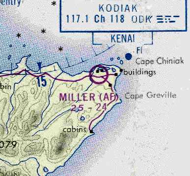
was on the March 1978 Kodiak Sectional Chart (courtesy of Chris Kennedy).
It depicted Miller as an Air Force airfield, but its listed runway configuration had been reduced to only a 2,400' unpaved runway.
Miller Field was evidently closed at some point between 1978-98.
A July 1998 photo by Joe Stevens of the differential GPS transmitter just beside the Miller Field runway.
In 1998 Joe Stevens reported that the Coast Guard had "recently installed a differential GPS transmitter just beside the Miller Field runway.
The runway condition is severely potholed and some of the rusty Marston matting has been partially removed.
It is NOT suitable for landing an airplane."
George Zonoff reported, “A visit to Kodiak in 2004 revealed the metal airstrip had been completely removed
and the landing strip is reverting to native vegetation & in several more years will be completely invisible.”
Karl Esch recalled, “In 2004 & 2006, we drove on what is left of Miller Field, which is not much.
The cattle corral, made in part from Miller Field matting is alongside the road to Pasagshak Bay.
The twisted pieces of matting are near what is now the Alaska Aerospace Development Corporation launch site on Near Cape, Kodiak.”
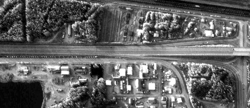
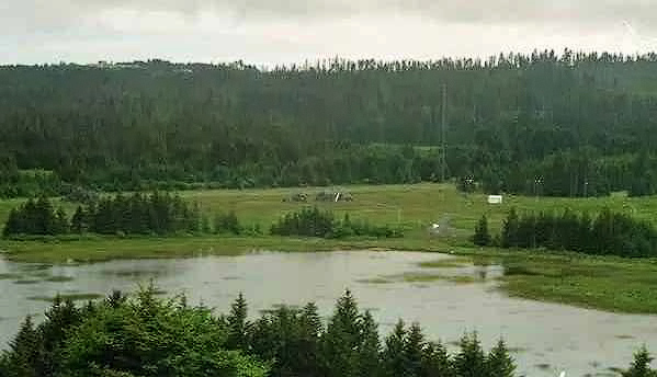
A 7/14/10 view looking southwest along Miller Field showed the runway to remain intact though deteriorated.
____________________________________________________
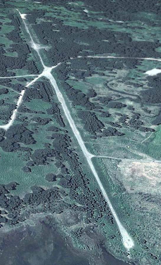
(Original) Huslia Airport, Huslia, AK
65.702, -156.382 (Northwest of Fairbanks, AK)
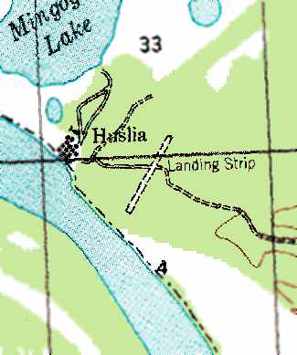
The original Huslia Airport, as depicted on the 1956 USGS topo map.
According to www.explorenorth.com, the first airport was constructed in the little community of Huslia in 1952.
The earliest depiction which has been located of the Huslia Airport was on the 1956 USGS topo map.
It depicted the “Landing Strip” southeast of the town as having a single northeast/southwest runway.
The original Huslia Airport,
as depicted on the May 1965 USAF Operational Navigation Chart (courtesy of Chris Kennedy).
The original Huslia Airport was described in the 1995 AOPA Airport Directory (according to Jonathan Westerling)
as having a single 3,000' gravel Runway 3/21.
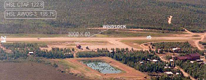
A 1995 photo of the original Huslia Airport (courtesy of the Alaska DOT, via Jonathan Westerling), while it was still open.
A small ramp along the southwest side of the runway had one small building,
but there did not appear to be any hangars.
In 1998 the decision was made to construct a new airport for Huslia that would meet current FAA standards
and provide safer year-round transportation (according to www.house.gov).
The new 4,000' runway was completed in 2000,
at which point the old airport was presumably closed.
According to the FAA, the cost of the new airport was $4,305,612.
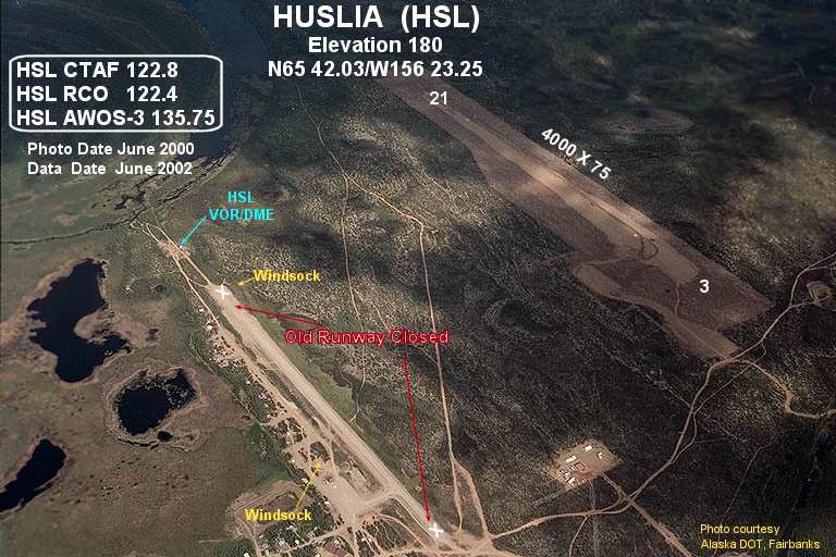
A 2000 photo (courtesy of the Alaska DOT, via Jonathan Westerling) of the original Huslia Airport (bottom left), along with the replacement airport (top right).
The original runway still exists intact, between the town & the new airport.
Thanks to Jonathan Westerling for pointing out this airfield.
____________________________________________________
Since this site was first put on the web in 1999, its popularity has grown tremendously.
That has caused it to often exceed bandwidth limitations
set by the company which I pay to host it on the web.
If the total quantity of material on this site is to continue to grow,
it will require ever-increasing funding to pay its expenses.
Therefore, I request financial contributions from site visitors,
to help defray the increasing costs of the site
and ensure that it continues to be available & to grow.
What would you pay for a good aviation magazine, or a good aviation book?
Please consider a donation of an equivalent amount, at the least.
This site is not supported by commercial advertising –
it is purely supported by donations.
If you enjoy the site, and would like to make a financial contribution,
you
may use a credit card via
![]() ,
using one of 2 methods:
,
using one of 2 methods:
To make a one-time donation of an amount of your choice:
Or you can sign up for a $10 monthly subscription to help support the site on an ongoing basis:
Or if you prefer to contact me directly concerning a contribution (for a mailing address to send a check),
please contact me at: paulandterryfreeman@gmail.com
If you enjoy this web site, please support it with a financial contribution.
This site covers airfields in all 50 states.