 What's New! Detailed Sitemap All images © by Roberto Piperno, owner of the domain. Write to romapip@quipo.it. Text edited by Rosamie Moore. Page added in July 2008. |
  - Seljuk Towns in Asia Minor - Seljuk Towns in Asia Minor(Sultanhan) Historical and Geographical Background Information The nomadic tribes of the deserts and steppes of Central Asia were for centuries at the border of the civilized world; they were for a short period ruled by the heirs of Alexander the Great, then they fell under the influence of the Persian Empire; when this was destroyed by the Arabs, also Central Asia was Islamized. However the imposition of Arabic was limited to the alphabet, because the local (Turkic) languages were not displaced. In the Xth century there was a migration of Turkish-speaking people into Persia; they were slaves and soldiers and they gradually rose in society maintaining their tribal bonds. They were named after Seljuk, the leader of one of these tribes. Togrul, a grandson of Seljuk, profiting from the crisis of the Caliphate of Baghdad, which formally had suzerainty over the Muslim world, established his rule over most of Persia. His successor Alp Arslan expanded Seljuk possessions to Georgia and Armenia, thus coming into contact with the Byzantine Empire. 
Clickable map of the towns covered in this section. The lighter area shows the approximate borders of the Sultanate of Rum. The green line indicates the 1896 railway linking the Asian side of Constantinople with Konya - the first leg of the Constantinople - Baghdad Railway (1900 Times Atlas of the World) In 1071 at Manzikert Alp Arslan defeated the Byzantine army which was led by Emperor Romanos IV who was captured. Alp Arslan agreed to release his prisoner in exchange for a ransom. But worse was yet to come for the emperor, as on his way back to Constantinople he was attacked by a Byzantine rival faction. He surrendered and resigned his rights to the throne. After having been brutally blinded by his enemies he was paraded through the streets of Constantinople on a donkey. He died a few days later. In the following years the Byzantines failed to recover from Manzikert and the Seljuks occupied most of Asia Minor. Their internal rivalries were such that the factions resorted to the Seljuks for help: in 1078 a rebellious general became emperor with the decisive support of a Seljuk army which occupied almost all of the Byzantine possessions in Asia. In 1097 Emperor Alexios I Komnenos with the help of the Crusaders managed to reconquer Nicea and parts of western Asia Minor, but the Seljuks maintained a firm control on its central and eastern sections.
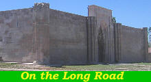
The Seljuk Empire was organized according to a feudal system; local rulers accepted the often nominal suzerainty of the emperor (sultan). In 1092 a dynastic quarrel led to a split of the empire: Kilij Arslan, one of the pretenders proclaimed the independence of the Sultanate of Rum which included central and eastern Anatolia. It was called Rum (i.e. Rome) because its territory had been part of the Roman Empire; in Europe it was called Sultanate of Iconium, after the Latin name of Konya, its capital. The Sultanate prospered; the Crusades threatened it, but at the same time they contributed to its wealth because they were a positive factor for trade between Europe and Asia. Venice and in particular Genoa established trading bases on the Aegean and Black Seas. Seljuk rulers built a net of caravanserais (or hans) which facilitated the flow of goods between these bases and Persia and Syria. The main route was called Uzun Yol, (Long Road) and it was an almost straight line which linked Konya with Kayseri (ancient Cesarea) and Sivas (ancient Sebaste) the two other main towns of the sultanate.
The Sultanate of Rum ended in 1243 when a Mongol army invaded Anatolia; it was an expedition having the sole objective of sacking and looting, but it weakened the supremacy of Konya over the other parts of the country. In 1276 a revolt against the Mongols saw some regional leaders manage to conquer Konya; eventually two groups increased their power: the Osmanli (Ottomans) who had their capital at Bursa in the north-western part of the country and the Karamanoglu (or Karamanids) in its southern part; the latter had their capital at Laranda (today Karaman) and they controlled Konya too. In 1403 central Anatolia was invaded by Timur (or Tamerlane) who defeated and captured Bayezid I, the Ottoman sultan. The Karamanids tried to take advantage of the Ottoman crisis and briefly conquered Bursa. The final confrontation occurred in 1468 when the Ottomans took Laranda, after having conquered Konya.
Central Anatolia is a vast tableland (height: 3,000-4,000 ft) surrounded by high mountains which prevent many rivers from reaching the sea. For this reason there are several lakes, the size of which varies according to the season; in summer, parts of them become dry and are covered by a thick layer of salt. The monotony of the landscape is interrupted by some extinct volcanoes. Even today large extensions of the tableland are almost unpopulated; the presence of water and of intensive farming is signalled by rows of poplar trees.
The tableland is separated from the Mediterranean Sea by the Taurus Range; only a few passes allow communication between the coastal region and the tableland; the valley of the Calicadnus (today Goksu River) is one of them together with the Cilician Gates near Lampron Castle.
This section
Although the title of this section makes reference to the "Long Road", the actual itinerary follows a different route to include Karaman and Mut. Towards the end of the XIXth century the Ottoman Empire, backed by the German one, decided on the construction of a railway to replace the old caravan trail. It was meant to link Constantinople with Baghdad and the Persian Gulf. Its first leg reached Konya: it was extended via Karaman and Adana to the Ottoman provinces in Syria and today's Iraq.
The Seljuks were imbibed with Persian culture and art: this section is mainly devoted to the monuments built by them, but there are also references to buildings and works of art of the civilizations which came before (Hittite, Roman, Byzantine) and of that which followed (Ottoman).
In some of the provincial towns covered in this section, the sight of a foreign traveller taking pictures is still unusual. Children are perfectly aware of the functioning of digital cameras and do not miss the opportunity of having an immediate portrait.
This section also shows some of the unique geological rocks of Cappadocia.
The image used as background for this page shows Mevlana's tomb at Konya. Move to: Konya Karaman Mut and Alahan On the Way to Nigde Nigde Kayseri Cappadocia Sivas Divrigi Map of Turkey with all the locations covered in this website     |


