Hoist Lakes Foot Travel Area
Manistee-Huron National Forest

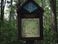
Hoist Lakes Foot Travel Area encompases 10,600 acres of Manistee-Huron National Forest that has been reserved for foot travel. Two connecting loops of wide trails create a 20 mile figure-8 shaped system through the area. Within reach are seven lakes, beaver ponds, meadows, marshes, and second growth forests of aspen, pine, and northern hardwoods. The terrain is hilly enough to be interesting, but not difficult to walk. The trails are well marked with blue diamonds and numbered markers.
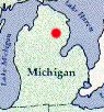
Its location, on the eastern side of the lower peninsula, makes it easliy accessable to the large population of southeastern Michigan. You can camp anywhere (200 feet from water or the trail), but there are very desirable prepared sites at Byron Lake on the western side and North and South Hoist Lakes on the eastern side. These sites are only a mile or so in from trail heads on the eastern and western sides of the area, so you may, as we did, run into groups that have hauled in huge tents and enough equipment for an expedition. From these base camps it is convenient to see the rest of the area by day hiking. There are also water pumps, one near the eastern trail head and one near the western trail head.
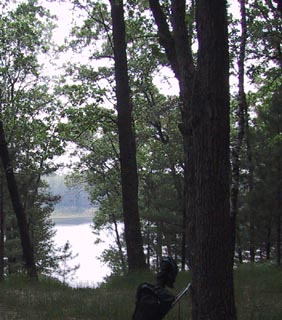
I had read that the camp sites at Byron Lake were particularly nice (left hand photo above) so we decided to camp there. It is about a two and one-half hour drive from Traverse City to the eastern trailhead. We started there about 11:30 A.M. and hiked across the bottom of the figure-8, arriving at the north side of Byron Lake at about 3 P.M. There are four sites on the north side of the lake that are above the lake so you get to look down on it. There are even a couple of rustic outhouses. We set up camp, walked the mile or so to the water pump where I filled a 3.5 Liter wide mouth Platypus container, and our 1 liter water bottles. There remainder of the day we spend relaxing, exploring around the lake, talking to other hikers, etc. This was mid June and the mosquitoes came out in hoards just before dusk, but we were prepared. As we settled in for the night we got to listen first to the churr...churr... of a red-bellied woodpecker, then a chorus of frogs from the lake, then a whip-poor-will, and finally a barred owl. A concert at Interlochen could not do better.
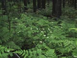
The next day, after sleeping in a bit, we had a very pleasant four hour hike around the northern porion of the figure-8, which passes over forested hills and down into mosquito infested beaver ponds and marshes. On the way home we stopped at the ranger station in the little town of Mio, where I was reminded that we are in Kirtland's Warbler nesting country. The Kirtland's Warbler is a true Michigan bird as it nests only in a very specialized habitat found in the central lower peninsula and, more recently in areas of the upper peninsula of Michigan. It winters in the Bahamas. The forest service has regularly scheduled tours of the the Jack Pine country were these birds nest. I have done this, years ago, so we passed it up this time.
For a trail map, contact the Manistee-Huron National Forest or stop at the ranger station in Mio or Harrisville. If you are a member of the GreatLakesHikes e-mail group you can down load a map by going to files section, then GLH_Events, and finally Maps.