Abandoned & Little-Known Airfields:
Virginia: Virginia Beach
© 2002, © 2016 by Paul Freeman. Revised 9/17/16.
This site covers airfields in all 50 states: Click here for the site's main menu.
____________________________________________________
Please consider a financial contribution to support the continued growth & operation of this site.
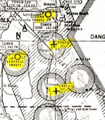
Creeds NOLF (revised 1/29/12) - Fentress NALF (revised 6/22/14) - Fort Story Aux AAF (revised 9/17/16) - Pungo NOLF (revised 5/7/13)
____________________________________________________
Fort Story Auxiliary Army Airfield, Cape Henry, VA
36.925, -76.03 (North of Virginia Beach, VA)
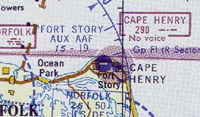
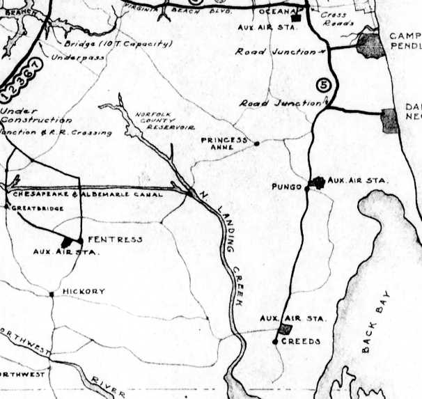
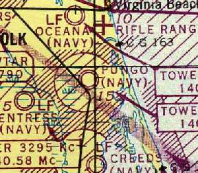
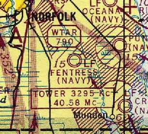
Fort Story Aux AAF, as depicted on the 1961 Norfolk Sectional Chart (courtesy of Chris Kennedy).
Fort Story is located at the tip of Cape Henry,
where the Chesapeake Bay meets the Atlantic Ocean.
The Fort was established in 1914, as a coastal artillery site,
intended to protect the entrance to the Chesapeake Bay.
These defenses were considerably expanded during WW2,
with many heavy guns mounted in fortified concrete batteries (the remnants of which still exist today).
After WW2, Fort Story eventually became the home to the Army's Transportation Command.
At some point between 1956-61, a small auxiliary airfield was constructed at Fort Story.
The purpose of the airfield is unknown.
The airfield was not yet depicted on the January 1956 Norfolk Sectional Chart (according to Chris Kennedy).
Dean Speir recalled, “The 'field' named for my father, Colonel Frank Speir...
[following] his death in a Beechcraft Bonanza over an aerodrome in Dunkirk, NY,
the Army sought to honor him & 'ground-breaking' fights in & out of Fort Story.
'Speir Field' was dedicated in his memory in September 1957.”
The earliest depiction of Fort Story Aux AAF which has been located
was on the 1961 Norfolk Sectional Chart (courtesy of Chris Kennedy).
It described the field as having a single 1,900' paved runway.
The earliest photo which has been located of the Ft. Story Airfield was a 3/3/63 USGS aerial photo.
It depicted Fort Story as having a single east/west asphalt runway,
with a grid of a large number of small buildings on the south side of the runway.
There did not appear to be any aircraft on the field.
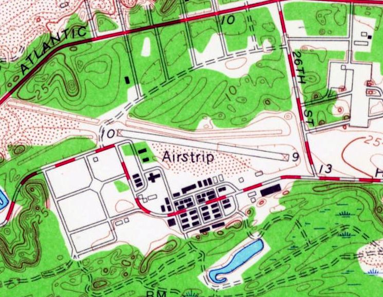
The 1964 USGS topo map depicted Fort Story Aux AAF as a single paved northwest/southeast runway, labeled simply as “Airstrip”.
The Aerodromes table on the 1965 Norfolk Sectional Chart (courtesy of John Voss)
described Fort Story Aux AAF as consisting of a single 1,950' steel mat runway.
Paul Stroman recalled, “There was a landing strip at Ft. Story.
I used to fly an L-19 from Ft. Eustis to there in 1966.”
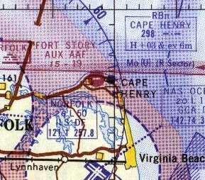
Fort Story Aux AAF was still depicted on the September 1967 Washington Sectional Chart,
and described as having a 1,900' runway.
Fort Story Aux AAF was still depicted on the 1969 USGS topo map.
However, it was evidently closed at some point between 1969-70,
as it was labeled "Closed" on the 1970 Washington Sectional Chart (courtesy of John Clifford).
Navy pilot Michael Strobach recalled, "We used charts we called JOGs when we flew around at night on NVGs.
These JOGs were an excellent resource for abandoned airfields.
Kind of like the US topographical maps.
I first noticed a field listed as 'Speir' on the tip of Cape Henry,
and the runway length was listed as 1,500'.
I used to fly my CH-46 over Fort Story & try to make out the field outline every time I flew over.
I even visited it on the ground, much to my patient wife's frustration!
There isn't anything on the ground that gives a clue to its history.
There is a clearing in the foliage & a long flat area."
"I also noticed that in the VFR Supplement that we fly with,
the helo pad at Fort Story is named 'Speir'.
They must have transferred the name."
Dean Speir recalled, “'Speir Field' stood until sometime in the 1990s when the memorial stone & plaque were relocated and it became 'Speir Heliport'.
Sometime after its half-century anniversary, the Army decommissioned it,
and it would have stayed that way if my sister hadn't raised a minor stink."
By 1998, the Fort Story airfield was no longer depicted at all (even as an abandoned airfield) on Sectional aeronautical charts.
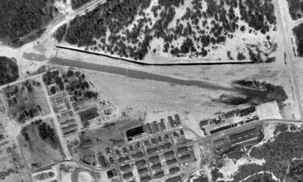
As seen in the 2001 aerial photo, the east/west alignment of the former airfield
is still somewhat recognizable, just north of the groupings of small buildings in the lower portion of the photo.
The site of the former airfield is located southwest of the intersection of Atlantic Avenue & Vung Tau Street.
____________________________________________________
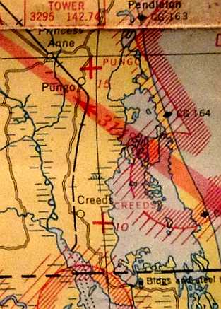
Pungo Naval Outer Landing Field, Virginia Beach VA
36.728, -76.012 (South of Oceana NAS)
“Pungo Auxiliary Air Station”, as depicted on an August 1943 Navy map (courtesy of Mark Hess).
There was no predecessor civilian airport at Pungo before WW2.
Stuart Chaplain reported, “The [Navy] airfield was the first - there was no previous airfield.
It was all farmland & I hoed too much corn to not know that.”
No airfield at this location was depicted on the 1939 USGS topo map,
the July 1941 Norfolk Sectional Chart (courtesy of Chris Kennedy),
nor the 1943 Regional Aeronautical Chart (courtesy of Chris Kennedy).
Pungo NOLF was commissioned in 1943 as a satellite airfield for nearby Norfolk Naval Air Station.
The station's intended mission was to support operations & training
of aircraft intended to operate from escort carriers.
A total of 24 such squadrons passed through Pungo during WW2,
most consisting of TBF or TBM Avenger torpedo bombers
and F4F or FM Wildcat fighters.
The earliest depiction which has been located of the Pungo airfield
was on an August 1943 Navy map (courtesy of Mark Hess).
The earliest aeronautical chart depiction which has been located of the Pungo airfield
was on a 1944 Regional Aeronautical Chart (courtesy of Chris Kennedy).
Pungo's facilities were expanded in 1944.
At its wartime height, the airfield consisted of three 2,500' concrete runways,
taxiways, two large concrete ramps, and a total of 82 buildings.
The station had a complement of up to 1,400 men.
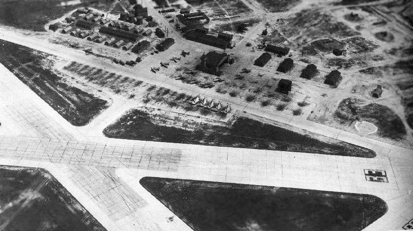
An April 1944 aerial view looking northwest at NAAS Pungo, showing an airfield with 3 concrete runways, and a ramp filled by Navy aircraft.
A WW2-era view of Pungo, looking northeast (National Archives photo), with the ramp filled by Navy aircraft.
A 3/18/45 aerial view looking northeast at Pungo NAAS from the 1945 AAF Airfield Directory (courtesy of Scott Murdock)
depicted the field as having 3 paved runways, with a large number of aircraft parked on the northwest ramp.
The 1945 AAF Airfield Directory (courtesy of Scott Murdock) described Pungo NAAS as “Inactive”.
The field was said to consist of a 441 acre irregularly-shaped property within which were three 2,500' concrete runways.
The field was said to have a single 111' x 53' wooden hangar,
to be owned by the U.S. Government & operated by the Navy.
"Pungo (Navy)" was still depicted on the April 1945 Norfolk Sectional Chart (courtesy of Chris Kennedy).
Following the end of the war, Pungo was disestablished by the Navy in 1945.
Pungo may have been operated for some period of time as a civil airport,
as "Pungo" was depicted as an auxiliary airfield (but not military)
on the September 1945 Norfolk Sectional Chart (courtesy of John Voss).
The last aeronautical chart depiction which has been located showing Pungo as an active airfield
was on the April 1946 Norfolk Sectional Chart (courtesy of Jim Stanton).
It continued to depict Pungo as an auxiliary civilian airfield.
Dean Speir recalled, “When we were at Fort Eustis in 1946, my dad started flying, and found it expedient to travel that way between Forts Eustis & Story.
Problem was, there was no landing strip there, other than Pungo, the decommissioned Naval aerodrome some miles distant.
When we were startioned at Fort Story later that year, he used to house the Bellanca at Pungo... and that was pretty deserted.”
A 1953 aerial photo showed 2 buildings remaining to the northwest of the Pungo ramp.
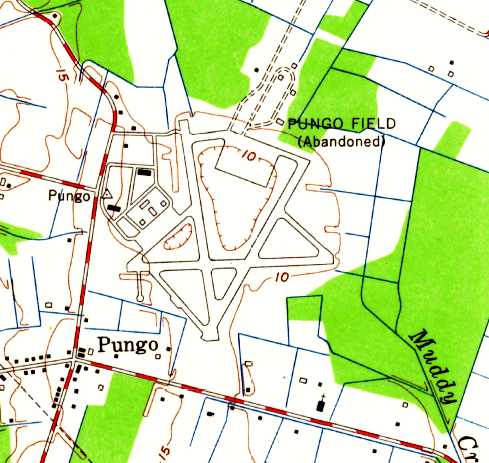
The 1954 USGS topo map depicted “Pungo Field (Abandoned)” as having 3 paved runways, taxiways, ramps, and several buildings.
According to Cort Tompkins, "When the facility was disestablished by the Navy,
the land immediately surrounding the airstrip was sold as farmland.
This now private farmland includes the apron at the end of the longest runway,
to which the Navy would taxi its fighters to sight in their 0.50 caliber machine guns
into a concrete-encased earthen berm 200-300 yards distant.
After its disestablishment by the Navy, the berm became an informal shooting range,
until the early 1970s when the farmer who then owned that portion of the airport
leased the area around the berm to the then newly-formed Virginia Beach Rifle & Pistol Club."
The Pungo airfield was labeled "Aband arpt" on the 1961 Norfolk Sectional Chart (according to Chris Kennedy).
A 1963 aerial photo appeared to show the abandoned airfield in an unchanged condition,
with 2 buildings remaining to the northwest of the Pungo ramp.
At some point between 1963-99, the Pungo property was turned over to the Coast Guard,
which constructed a radio transmitter site over much of the former airfield.
This facility is still in use today by the Coast Guard.
There are many radio towers spread throughout the airfield property,
along with several maintenance buildings situated along the west side of Runway 4/22.
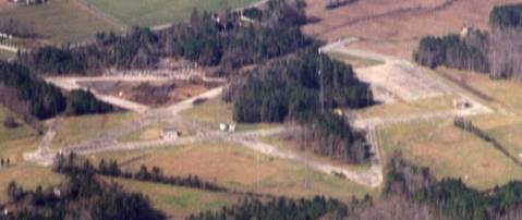
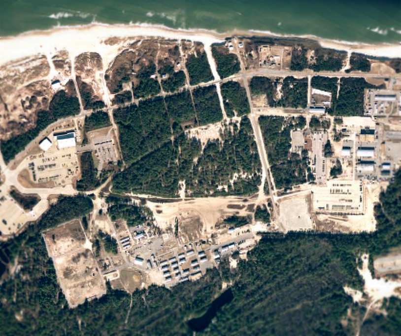
An 11/99 aerial photo by Paul Freeman looking northwest at the Pungo airfield, taken from a Diamond Katana DA20A-1.
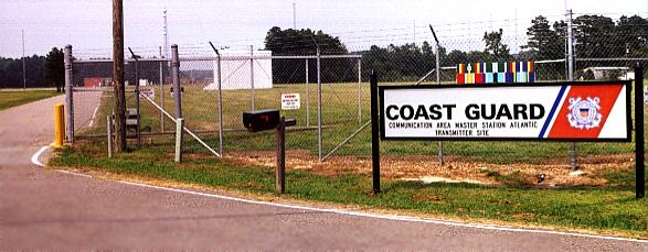
A 7/00 photo by Paul Freeman looking north at the entrance to the current Coast Guard facility at the Pungo airfield.
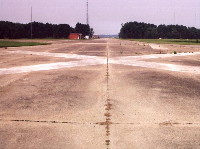
A 7/00 photo by Paul Freeman of the view along Runway 4,
showing radio towers & maintenance buildings along west side of runway.
Paul Freeman visited the site of the Pungo airfield in 2000.
A public road intersects the northern end of Runway 18/36,
and runs over a portion of the taxiway before turning north just before the main ramp area.
All of the runways, taxiways & ramps still existed, in excellent condition.
As of 2000, the Pungo airfield was not depicted at all (even as an abandoned airfield) on current aviation charts,
but was shown as an airfield on local road maps.
Cort Tompkins reported in 2004 that the earthen berm at Pungo
remains in use by the Virginia Beach Rifle & Pistol Club "to this day (imagine all the lead in there!).
Sadly, that portion of the former airport is now being sold to a residential developer -
who will have to find a way to remove the berm as well as several WWII-era bunkers near the airstrips!"
The portion of the airstrip currently retained by the USCG will remain with the USCG.
Also interesting is that the CG-owned portion of the airstrip has now been encircled
with a make-shift wall of huge chunks of concrete debris placed inside the property's chain-link fence.
This likely occurred as a post-9/11 security measure."
A circa 2005 aerial view looking north at the ramp & several runways at the Pungo airfield.
A 2005 aerial view of the Pungo airfield.
A 5/30/10 photo by Don Michalek of an abandoned building at the site of the Pungo airfield.
Don reported, “Over the memorial weekend, the Pungo community opens up the old Pungo NAAF to use as a parking area for the Pungo Strawberry Festival.
Its a rare opportunity to go 'exploring' around the old field.”
A 5/30/10 photo by Don Michalek “looking around the corner of a road that emptied onto the tarmac.”
James Gant reported in 2011, “Pungo Airfield is also now host to an Sports Car Club of America autocross event, and has been for quite some time now.
The event is run by the Old Dominion Region of the SCCA.”
____________________________________________________
Creeds Naval Outer Landing Field (64VA), Creeds VA
36.605, -76.007 (South of Oceana NAS)
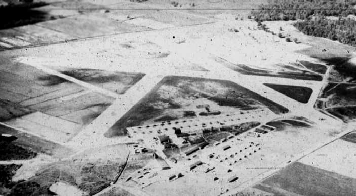
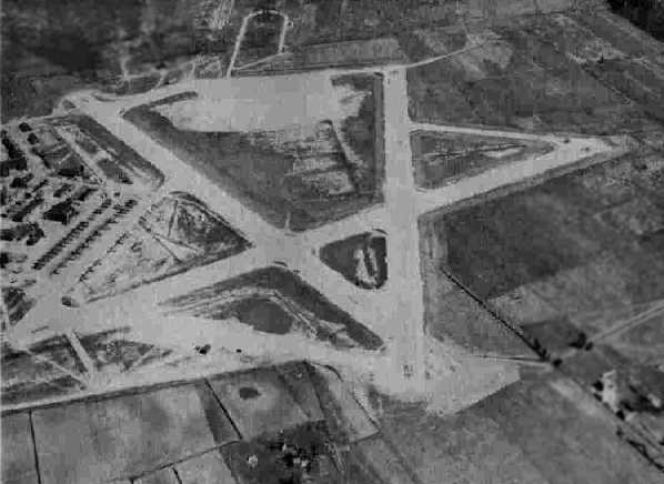
A circa 1941-43 aerial view looking south at Creeds (courtesy of Mark Hess).
Creeds NOLF is located south of Pungo NOLF, along the Atlantic Coast.
No airfield was depicted at this location on the 1939 USGS topo map.
The Navy began construction at the site in mid 1940
of an Outlying Landing Field to support training operations at NAS Norfolk.
The airfield at Creeds was not depicted at all on the July 1941 Norfolk Sectional Chart (courtesy of Chris Kennedy)
or the 1943 Regional Aeronautical Chart (courtesy of Chris Kennedy).
The earliest depiction which has been located of Creeds
was a circa 1941-43 aerial view looking south (courtesy of Mark Hess).
It depicted the field as having 3 paved runways, with a number of aircraft on a paved ramp on the north side.
Creeds was commissioned on 4/5/43 as an auxiliary of NAS Norfolk,
with its mission being the support, operations, training, and maintenance of fleet squadrons.
“Creeds Auxiliary Air Station”, as depicted on an August 1943 Navy map (courtesy of Mark Hess).
The Navy had intended Creeds to function as a base for composite squadrons
of Wildcats & Avengers that would eventually serve on small CVE escort carriers.
The first squadron to arrive at Creeds was VF-1 (appropriately enough!),
followed by VC-52, VB-8, VF-13, and VB-15 throughout 1943.
In early 1944, composite squadrons VC-15, VC-95, and VC-42 had passed through Creeds.
The complement at Creeds reached a total of 1,383 personnel in 1944.
The station was assigned 2 base aircraft, usually GH Howards.
The earliest aeronautical chart depiction which has been located of Creeds
was on a 1944 Regional Aeronautical Chart (courtesy of Chris Kennedy).
CAG-27, CAG-28, and VT-153 were based at Creeds in early 1945.
An expansion program in early 1945 included the installation of permanent lighting,
additional barracks, and additional aircraft parking areas.
The airfield eventually consisted of 3 concrete runways (the longest being 2,500'),
taxiways, and a large ramp area.
The construction program was completed on 8/1/45, just in time for the end of WW2.
A WW2-era view of Creeds, looking south (National Archives photo),
with a large number of Navy aircraft parked on the ramp.
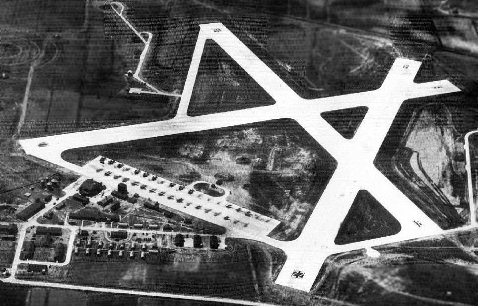
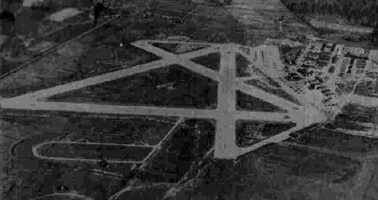
A 3/15/45 aerial view looking north at Creeds NAAS from the 1945 AAF Airfield Directory (courtesy of Scott Murdock)
depicted the field as having 3 paved runways, with a large number of aircraft parked on the northeast ramp.
"Creeds (Navy)" was still depicted on the April 1945 Norfolk Sectional Chart (courtesy of Chris Kennedy).
The 1945 AAF Airfield Directory (courtesy of Scott Murdock) described Creeds NAAS as inactive.
The field was said to consist of a 272 acre irregularly-shaped property within which were three 2,500' concrete runways.
The field was said to have 2 wooden hangars (111' x 59' & 77' x 20'),
to be owned by the U.S. Government & operated by the Navy.
Following the end of WW2, Creeds may have been operated for some period of time as a civil airport,
as "Creeds" was depicted as an auxiliary airfield (but not military)
on the September 1945 Norfolk Sectional Chart (courtesy of John Voss).
Creeds was decommissioned by the Navy on 10/15/45.
The last aeronautical chart depiction which has been located showing Creeds as an active airfield
was on the April 1946 Norfolk Sectional Chart (courtesy of Jim Stanton).
It continued to depict Creeds as an auxiliary civilian airfield.
Some sources indicate that Creeds was still used by the Navy as an Outlying Landing Field into the 1950s
(but perhaps this was in an unofficial capacity).
A 1953 aerial photo did not show any indication of recent aviation usage.
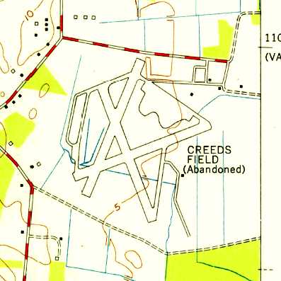
The 1954 USGS topo map depicted “Creeds Field (Abandoned)” as having 3 paved runways, taxiways, ramps, and several buildings.
The Creeds property was conveyed by the Federal Government to the local government in 1961.
It was labeled "Aband arpt" on the 1961 Norfolk Sectional Chart (according to Chris Kennedy).
Thomas Belvins recalled, “ I can remember drag racing at Creeds from my high school days in the early 1960s.”
This reportedly continued into the early 1970s.
At some point between 1961-76 Creeds was apparently reused as a private civilian airfield,
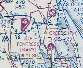
as that is how "Creeds" was depicted on the November 1976 CG-21 World Aeronautical Chart (courtesy of Chris Kennedy).
It was depicted as having 2 paved runways, with the longest being 2,500'.
Don McMahon recalled, “I was a Police Officer in Virginia Beach during the mid-late 1970s
and I know that Creeds was used for organized drag racing on weekends;
we were detailed to it checking for underage drinking & crowd control.
We also used it for driver training, and got ‘buzzed’ once or twice by fighters doing touch & goes.
At the time there were more than a couple of hulks laying around in the woods.”
The use of Creeds as a private airfield evidently ended at some point between 1976-93,
as it was no longer depicted at all on the March 1993 Washington Sectional Chart (courtesy of Carl Taylor).
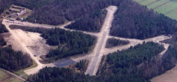
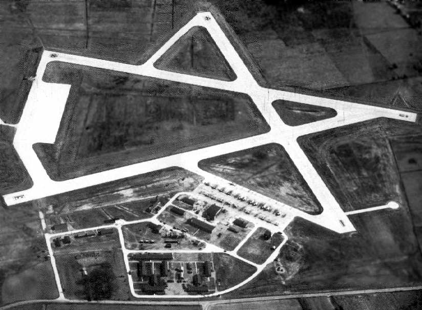
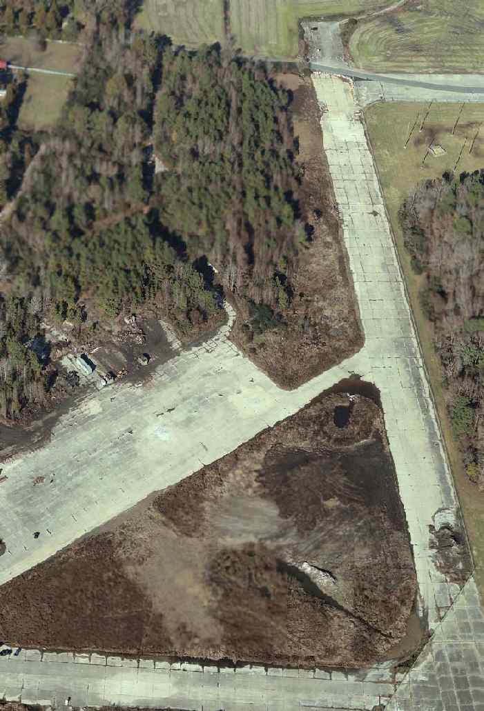
A November 1999 aerial view by Paul Freeman looking southeast at the Creeds airfield.
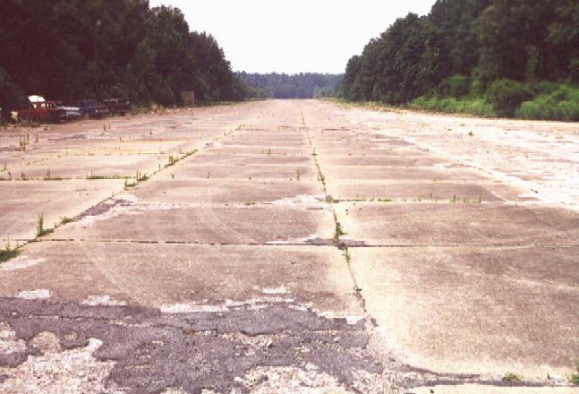
A 7/00 photo by Paul Freeman of Creeds' Runway 35.
Note wrecked cars along west side of runway.
A 7/00 photo by Paul Freeman of the main ramp area at the northeast portion of Creeds NOLF.
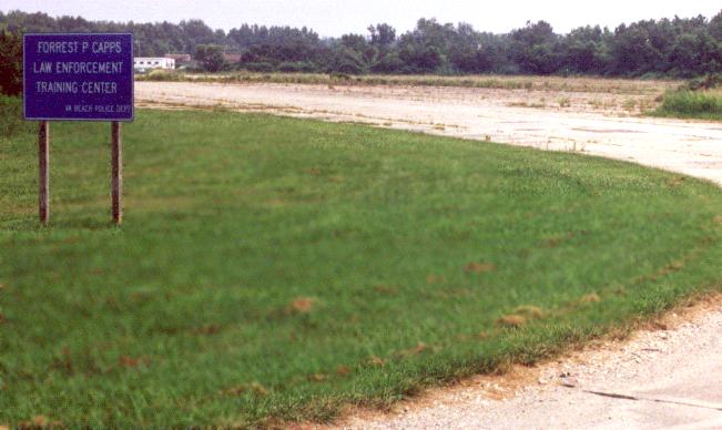
The sign gives the current name of the site - the "Forrest P Capps Law Enforcement Training Center",
whose complex of buildings are visible directly behind & to the right of the sign.
The property is used by the Virginia Beach Police Department as a training area.
They have a complex of trailers & other small buildings at the east end of Runway 8/26,
and abandoned cars & trailers are scattered about the ends of the other runways.
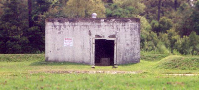
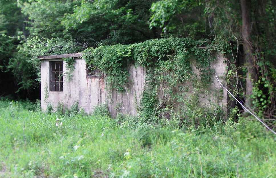
A 7/00 photo by Paul Freeman of the only remaining original building at Creeds:
a curious little single-story concrete structure which sits along a circular concrete road
along the southern edge of the large ramp area at the north end of the airfield.
Two signs say: "Warning. Bio chemicals. Keep out. Gas mask eye protection required."
The original purpose of this building is unknown.
As of 2002 the Virginia Beach Police Department also maintained the only remaining aviation use of the airfield:
a 500' x 175' portion of Runway 3/21 was occasionally used for operations by their Bell 206B helicopters,
and was designated "Creeds Heliport" (VA64).
Although the Airport Facility Directory listed 2 helicopters as being based at the facility,
there was no evidence at the site to suggest any aircraft were currently based there.
The target adjacent to the east side of the airfield was Target #1,
and the target further east was Target #2.
In recent aerial pictures, no trace remains of either of these targets.
Cort Tompkins reported in 2004, "the Virginia Beach (and formerly Princess Anne County) Sheriff's Department
(and now also Virginia Beach Police Department) up until very recently used a berm
in that airstrip area as a firing range.
Due to complaints from residents (and bullets discovered in nearby homes),
the city is now constructing an alternate range in North Carolina.
Further, while the Police Department may land their helicopters at Creeds from time to time,
they are not stationed there (they're farther north, near the municipal center)."
Creeds was not depicted at all (even as an abandoned airfield) on current aviation charts,
but shown as an airfield on local road maps.
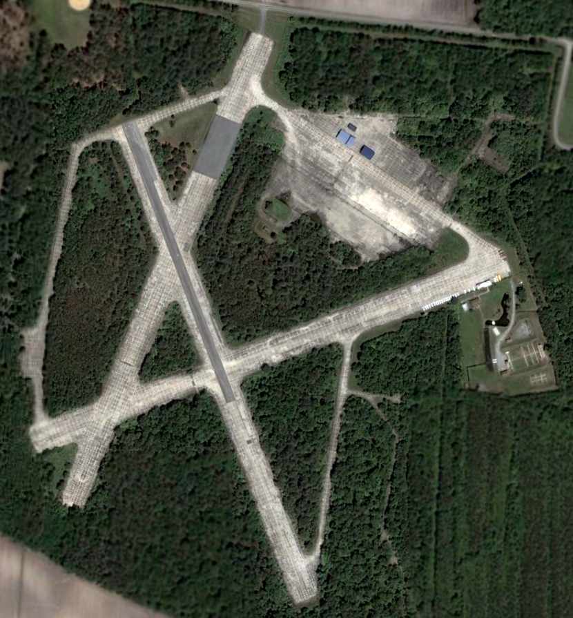
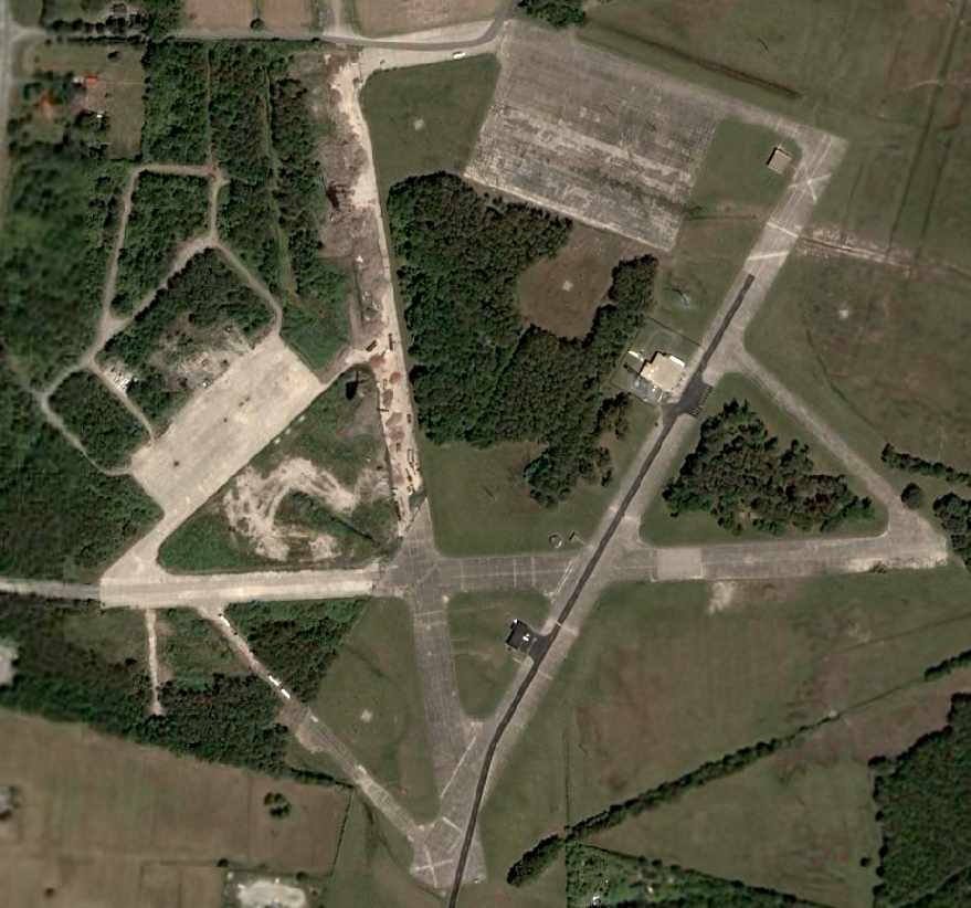
A 2005 aerial view of the Creeds airfield.
A circa 2006 aerial view looking east at the north end of the Creeds airfield.
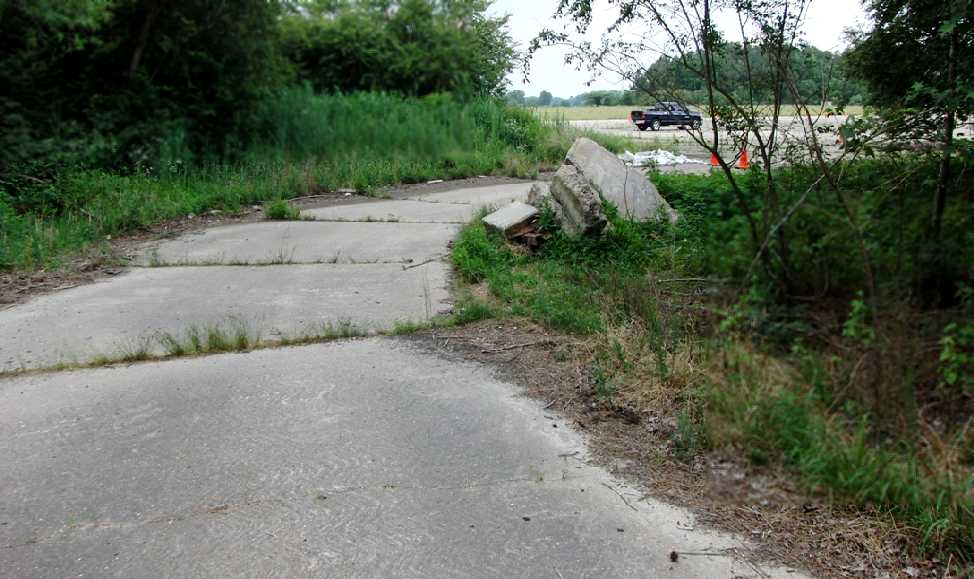
A circa 2006 photo looking south along the former Runway 17 at Creeds.
The Creeds Heliport was evidently closed at some point between 2002-2009,
as the facility was no longer listed with the FAA as a current heliport as of 2009.
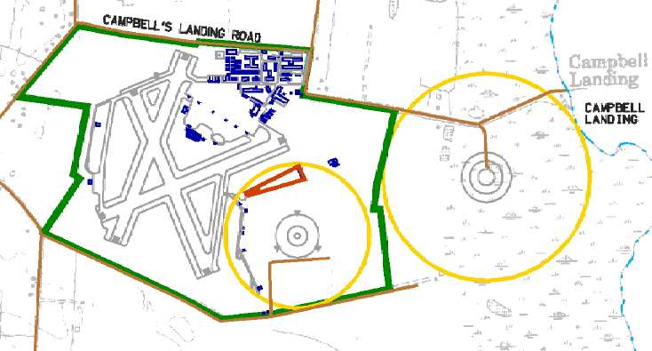
A 2009 plan of the “VA Beach Police Department Law Enforcement Training Center Creeds” (courtesy of Christopher Epperson),
showing the road courses which are planned to be overlaid on the former runways & taxiways.
Christopher reported in 2009, “We are about to reopen the police training facility at Creeds.”
He also indicated that plans were being made to commemorate the Navy personnel who had used the Creeds airfield in years past.
See also: http://pirs.mvr.usace.army.mil/fuds/m-p/navalax/preasses/inpr/11.htm
____________________________________________________
Fentress Naval Auxiliary Landing Field (NFE), Chesapeake, VA
36.705, -76.133 (Southwest of Oceana NAS)
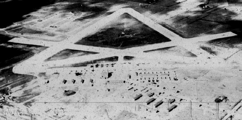
A circa 1941-43 aerial view looking southwest at Fentress (courtesy of Mark Hess).
Fentress was originally commissioned on 4/15/43 as one of several satellite airfields for Norfolk NAS.
The base was primarily home to composite squadrons
of FM Wildcats & TBM Avengers that would eventually serve on small CVE escort carriers.
Fentress could accommodate up to 3 squadrons,
typically composed of 9 Wildcats & 12 Avengers.
The earliest depiction which has been located of Fentress
was a circa 1941-43 aerial view looking southwest (courtesy of Mark Hess).
It depicted the field as having 4 paved runways, with a large number of buildings on the east side.
“Fentress Auxiliary Air Station”, as depicted on an August 1943 Navy map (courtesy of Mark Hess).
Several composite squadrons passed through Fentress in 1943.
The base was designated as a night flying field in 1944,
and Field Carrier Landing Practice night training commenced.
The base's complement peaked in 1944 with a total of 1,384 personnel.
Aircraft assigned to Fentress included six SNJs, an NE Piper Cub, a PBY Catalina amphibian, and a GH Howard.
A new construction program was begun in 1944.
Fentress temporarily closed for a month for the installation of runway lighting.
The earliest aeronautical chart depiction which has been located of Fentress
was on a 1944 Regional Aeronautical Chart (courtesy of Chris Kennedy).
A WW2-era National Archives picture of the Fentress ramp.
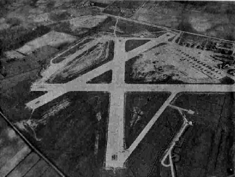
A 3/18/45 aerial view looking north at Fentress NAAS from the 1945 AAF Airfield Directory (courtesy of Scott Murdock)
depicted the field as having 4 paved runways, with a large number of aircraft parked on the northeast ramp.
The directory described Fentress as a 388 acre irregularly-shaped property within which were four 2,500' concrete runways.
The field was said to have one wooden 111' x 58' hangars,
to be owned by the U.S. Government & operated by the Navy.
By the end of WW2, the Fentress airfield consisted of four 2,500' concrete runways,
along with numerous taxiways & large ramp areas.
Fentress was placed in Caretaker status in 1946,
and became an Outlying Landing Field for NAS Oceana.
According to Robert Crabtree, “When WWII was over all the buildings were locked & boarded up.
They hired one local man as caretaker named McClanahan.”
According to Robert Crabtree, CWO Davidson was the first commander of NALF Fentress after it was reopened.
In the postwar period, with higher-performance aircraft starting to be operated from Oceana,
with their attendant need for much longer runways,
a modern 8,000' paved Runway 5/23 was built at Fentress at some point between 1946-51.
Robert Crabtree served at Fentress starting in 1951.
He recalled, “All furnishings, tools, pencils, some weapons & ammunition were uncovered when we moved in.
I had purchased a commercial speed graphic camera & set up my own darkroom in one of the empty buildings.
The Oceana Crash & Salvage Crew sent a crash crew to NALF Fentress on a daily basis
to stand-by for carrier practice shortly after adding the 8,000' runway.
A short time later a crew of about 35 men were sent there full-time.
Many of these people were Reservists & their talents varied making this crew most unique & interesting.”
Robert continued, “Fentress was located deep in the Dismal Swamp.
We were about 8 miles away from the one good bar there named Kay's Place
that we all visited almost on a daily basis.
The Navy allowed us to use a vehicle to make one run twice a day to the nearest bus stop.
For convenience we stole a bus stop sign & installed it in front of the bar.
Most of the time our vehicle of choice was our Navy ambulance.”
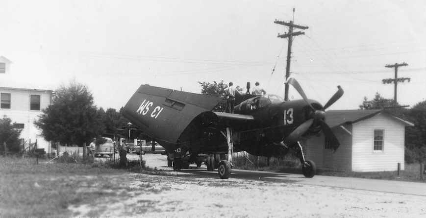
A 1952-53 photo by Robert Crabtree of a Grumman AF-2 Guardian, “Unlucky #13...
being towed out the Fentress Gate back to NAS Oceana after landing at Fentress wheels up.”
Robert Crabtree recalled, “Carrier practice was done with a Landing Signal Officer,
Radioman with communication trailer & a couple of others to keep records.
They would come down from Norfolk or Oceana & fly with 4 planes
in carrier operational formation at a height of about 300 feet on base leg.
They would hang the plane by the prop & drop on the cut.
They would touch down & give her the gun & go around again in the same for hours.”
Robert continued, “Some units would bring us donuts, we would furnish coffee
and would watch the Arthur Godfrey show on TV.
They would also come with their swim suits.
There is a good sized lake across the road from the front entrance
that was formed from fill they used when the 8,000' runway was built.
It was one of the best fresh water swimming holes anywhere around.
The store at the gate was owned by Mennonites.”
Robert continued, “Oceana would send about 7 tractors & mowing machines
down to mow our acres several times a year.
We would have drag races on the airfield if they were left there over the weekend.
Once 2 collided & a transfer case was busted.
We paid a local old time Mennonite blacksmith big time to forge
and weld the cast iron transfer case that was busted.
We had plenty of Navy gray paint. No one ever knew what we had done.”
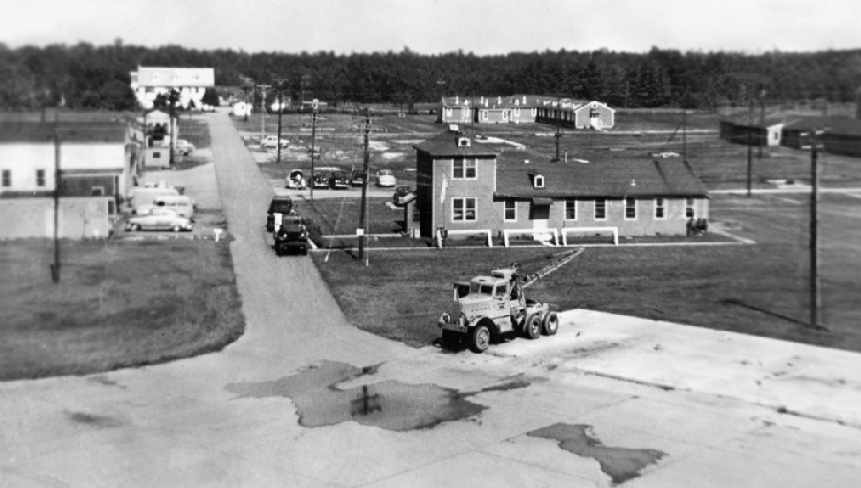
A 1954 photo by Robert Crabtree of the buildings of NALF Fentress, taken from the control tower.
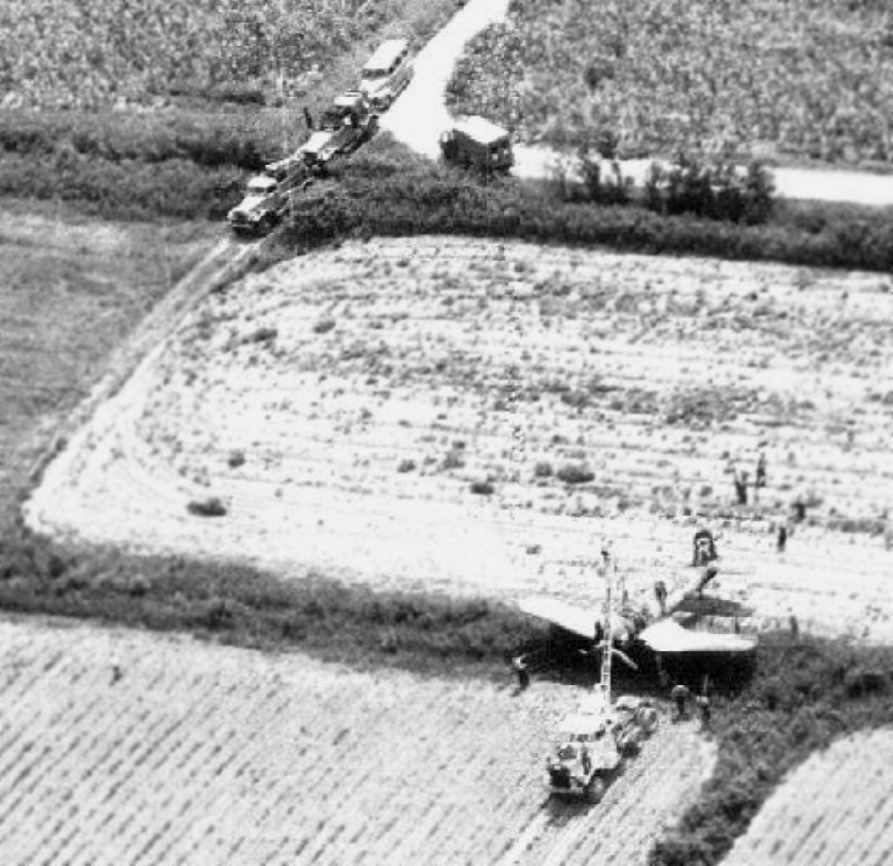
A 1953 photo by Robert Crabtree of an F4U Corsair which crashed off the end of the Fentress runway.
According to Robert, “This was quite an undertaking getting the plane across irrigation ditches.
Just about all our equipment is shown in this photo.
The Corsair photo was just by chance taken by me.
I had been driving a large Tournapull Crane to the site that had rear wheels 10 feet wide apart on center.
I had to go across several of those irrigation ditches with drain pipes that were 10 feet long.
One had been collapsed that stopped me in my tracks.
The chopper was flying overhead, I waved him down, he picked me up & I was able to take the photo on the way in.”
Robert Crabtree recalled, “I had never heard of the Confederate Air Force.
A Reserve squadron came from Houston for their 2 weeks, many of them were Colonels.
Now this was the most interesting time of my life.
They were flying F6Fs, F4Fs, F4Us and an F8F.
I was asked to take photos of one of them buzzing the field.
I got in the middle of the runway & this dude flew with his prop about 6 inches from the ground.
I ran & was told not to worry that the pilot was one of the best & was a Colonel in the Confederate Air Force.
It took a lot of talk to get me to believe them. I took the photos & they were happy.
The Corsair may have been one of those guys.”
The 1961 & 1965 Norfolk Sectional Charts (according to Chris Kennedy)
depicted both the old & new runways at Fentress,
and the Aerodromes table on the charts listed the number of runways as 5.
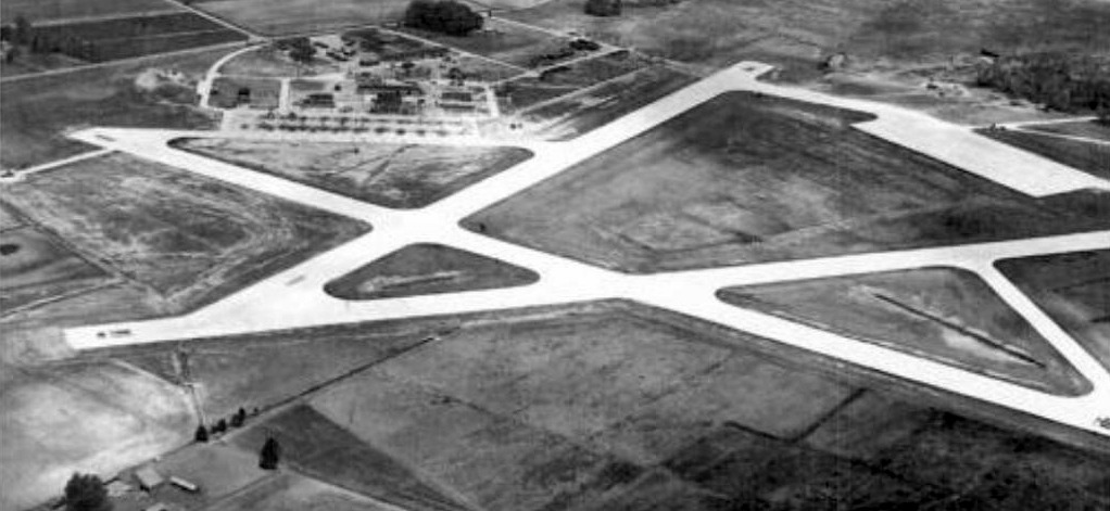
A 1966 aerial view by Ralph Bigelow looking southwest at Fentress Field.
Ralph recalled, I was “stationed there as top turret operator on an MB5.”
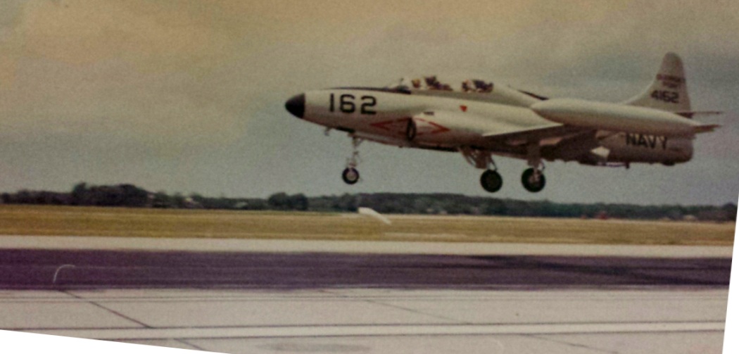
A 1966 aerial view by Ralph Bigelow of a Lockheed T-1A SeaStar making an approach at Fentress Field.
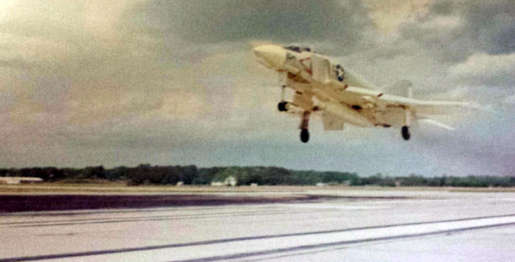
A 1966 aerial view by Ralph Bigelow of a McDonnell F-4 Phantom making an approach at Fentress Field.
A June 21, 1974 DOD aerial view by PHC Barnes, looking north at Fentress Auxiliary Landing Field,
with the modern runway in the foreground & the WW2-era runways in the background.
"ALF Fentress (Navy)", as depicted on the November 1976 CG-21 World Aeronautical Chart (courtesy of Chris Kennedy).
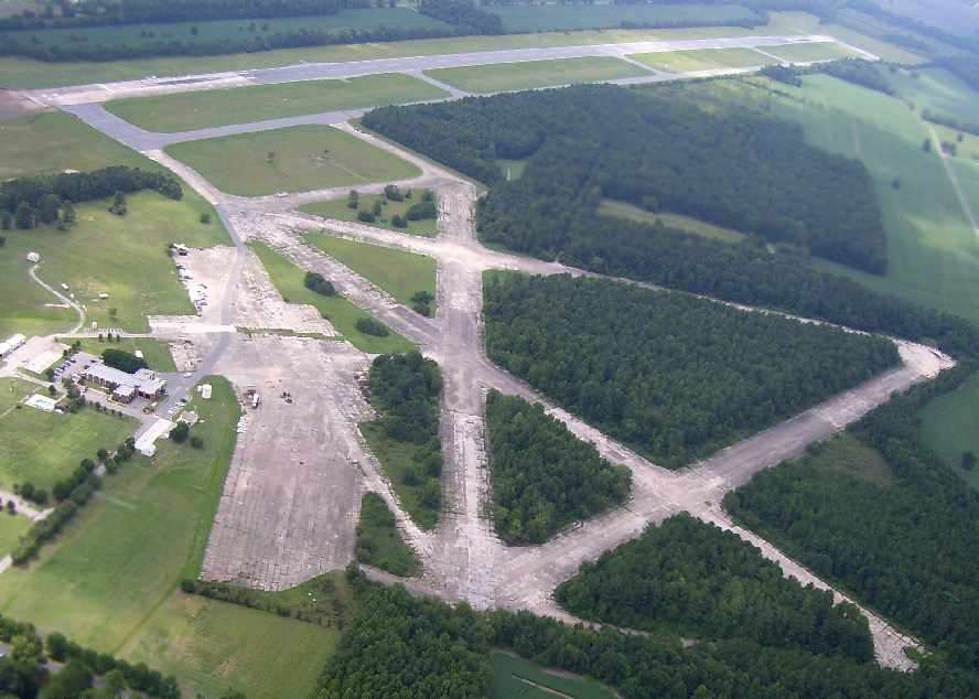
At some point after 1965, the original WW2-era runways at Fentress were abandoned,
with the single postwar jet-capable runway being the only one still used.
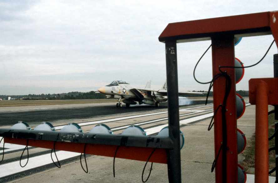
A November 30, 1987 DOD photo by Joseph Higgins of a Fighter Squadron 143 Grumman F-14A Tomcat
making a practice carrier landing at Fentress Auxiliary Landing Field.
The Fresnel Lens Optical Landing System lights are in the foreground.
Fentress is still in use as a satellite airfield for NAS Oceana today.

An aerial photo taken by Paul Freeman 11/99, from a Diamond Katana DA20A-1, looking northeast at the Fentress airfield.
On April 9, 2001 an F-14A (159591 / AD-225 / cn 138) of VF-101 Grim Reapers
belly-landed at Fentress after suffering a landing gear failure.
According to Scott Shea, “The F-14D had a nose landing gear failure. The nose landing gear failed to extend.
I heard it actually had the issue at NAS Oceana, which it was then told to land at Fentress for unknown reasons.
It landed & skidded down the runway on its nose; pilot & WSO uninjured.
It was removed from the runway & the squadron could be seen robbing/removing/cannibalizing it for parts on weekends.”
What a sad end for such a mighty Mach 2 fighter.”
However, Curtis Rohnert reported, “I was part of the team sent in to salvage peaces off the F-14 that landed there.
The Navy use to use a civilian contractor with some Navy personal to supplement.
Myself & another sailor were a part of this team.
I was onboard for 3 months. My permanent Squadron being VF-211.
The team was called SARDIP. I can't remember what that stood for,
but I can say that the aircraft did not have a nose gear failure, all gear were lowered after touchdown.
That’s why the main gear look collapsed.
If it did have a nose landing gear failure the main gears would still be down & locked.”
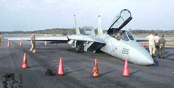
The F-14A which belly landed at Fentress on April 9, 2001.
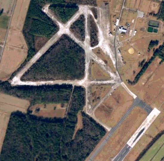
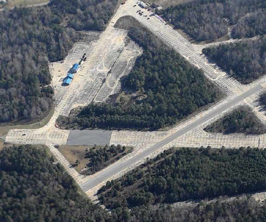
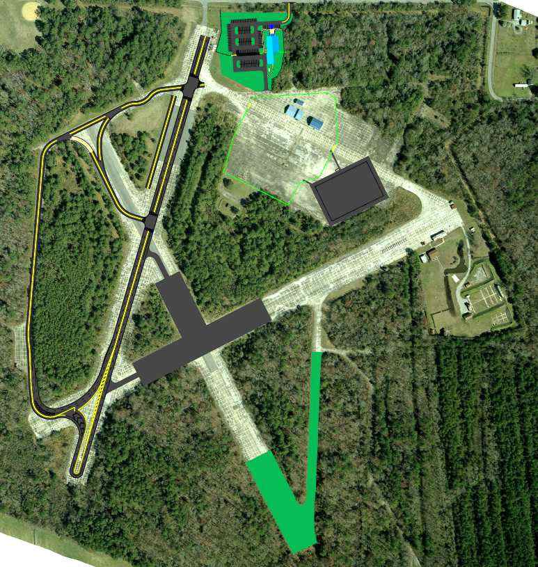
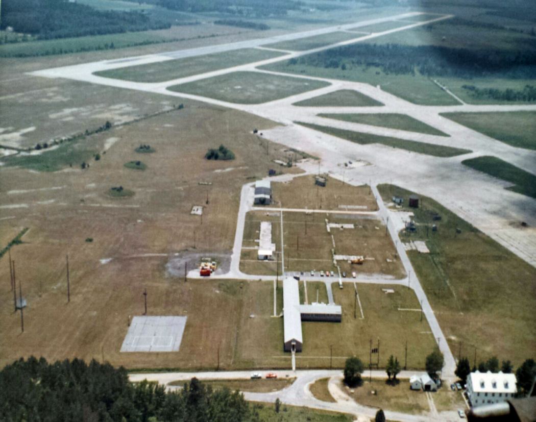
A circa 2000 aerial view of the WW2-vintage portion of Fentress.
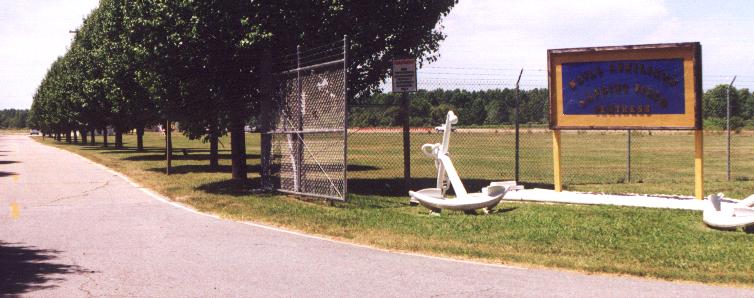
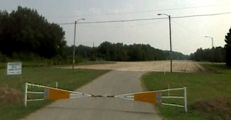
A 7/02 photo by Paul Freeman of the Fentress NALF entrance.
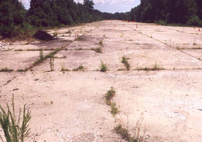
A 7/02 photo by Paul Freeman of the view along Fentress' original Runway 5.
Note traffic cones at the far end of the runway -
Portions of the abandoned runways are used for driver training
by the Virginia Beach Police Department.
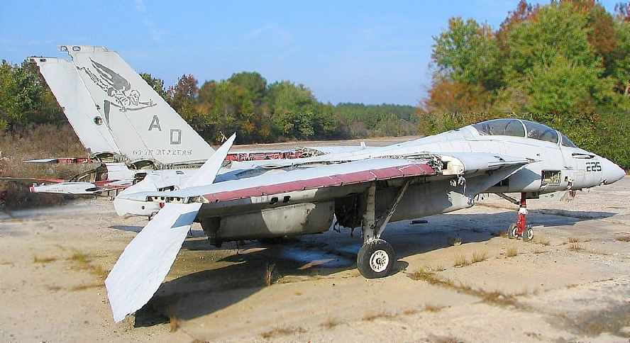
An October 2004 photo by Michael Carlyle of the F-14A which had belly landed at Fentress on April 9, 2001.
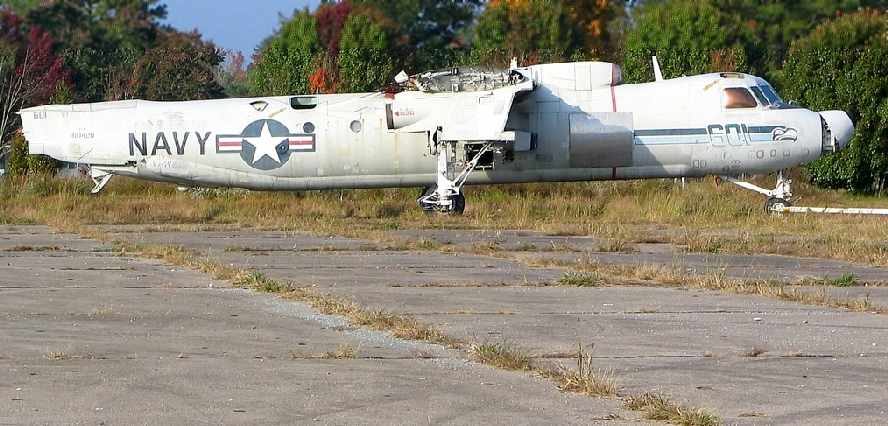
An October 2004 photo by Michael Carlyle of the E-2C (160420 / AC-601 / cn A040) of VAW-126
at Fentress which had hit a deer while taxiing at night.
Michael reported, “The deer ran into the prop & was thrown through the fuselage damaging the airframe beyond repair.
You can see a shiny aluminum patch just ahead of the wing to repair the skin where the deer entered the fuse.
The airframe is now used for fire practice.”
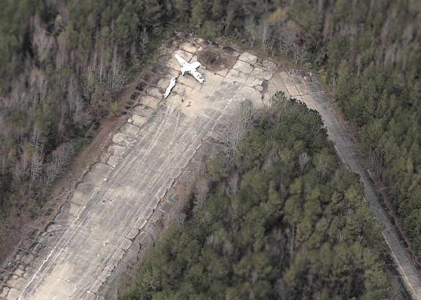
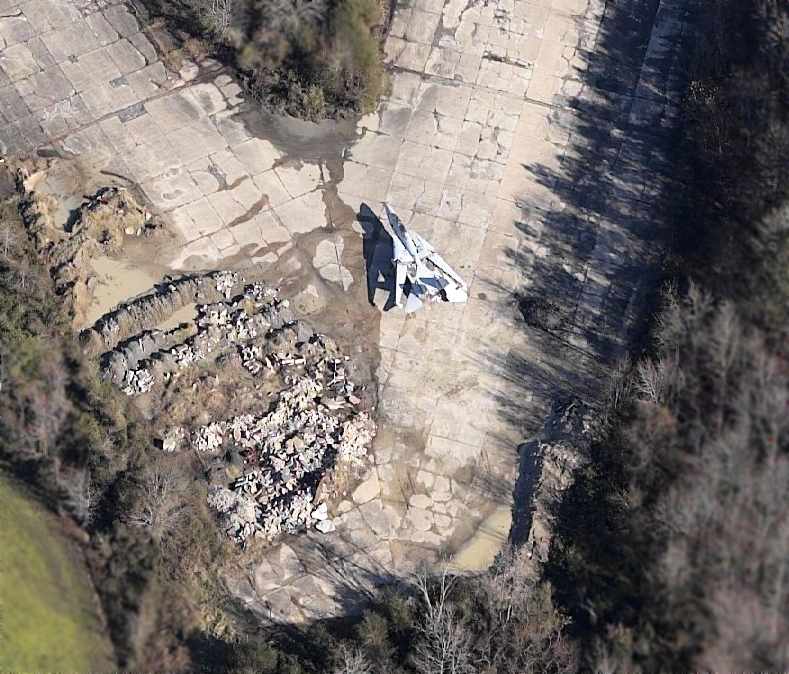
A circa 2005 aerial view looking west at what appears to be the fuselage of a Grumman E-2 Hawkeye,
along with an unidentified fuselage structure,
which sit at the northwest corner of the abandoned WW2-era Fentress runways.
Scott Shea reported in 2006, “The E-2 Hawkeye is actually there because it hit a deer in the runway.
The carcass of the deer entered the blade arc & was slung through the fuselage of the Hawkeye.
They deemed the aircraft structurally unairworthy.”
A circa 2005 aerial view looking east at the Grumman F-14 Tomcat,
which sits at the southwest corner of the abandoned WW2-era Fentress runways.
Scott Shea reported in 2006, “On Weekends, NALF Fentress is open for radio controlled aircraft modelers.
Its one of the best R/C sites in the area; we use the taxiway as the runway.
Occasionally, we get asked by the ABF's to cease operations because of inbound aircraft.
They practice carrier landings just a few hundred feet in front of us!
Its frustrating to have to stop flying for a while but at the same time,
how many chances do you have to see F-14s & F/A-18s practice carrier landings that close!”
Even though Fentress was built as an "outlying" field,
the rapidly growing suburbs of Virginia Beach have been expanding ever more closely to the field.
This has resulted in considerable pressure by the local community on the Navy
to cease operations at Fentress, replacing it with yet another outlying field,
even further from the current suburban sprawl.
It seems to matter not that those who complain about the jet noise over their newly built suburbs
in fact chose to move next to an military airfield that was there before they were.
Your tax dollars at work.
An August 2007 aerial view by DC Air National Guard flight engineer Kent Ferrell looking south at the Fentress airfield.
Kent reported, “I took the picture from our C-130 while we were doing some training out of Oceana NAS.”
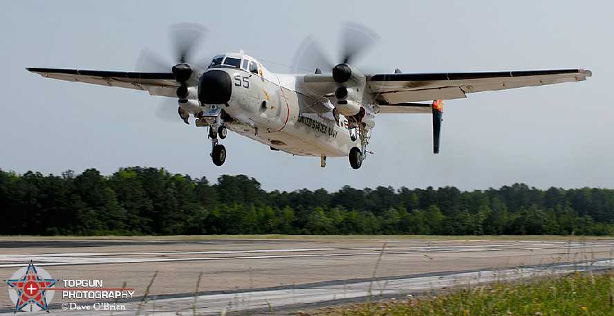
A circa 2008 photo by Dave O'Brien taken from the Fentress LSO station, showing a C-2 Greyhound on short final.
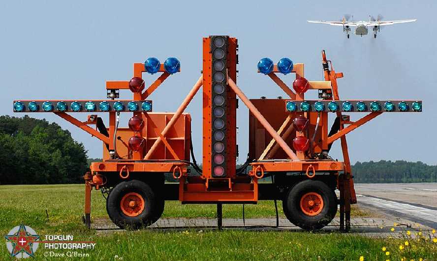
A circa 2008 photo by Dave O'Brien of the FLOLS system at Fentress, with the C-2 Greyhound climbing out in the background.
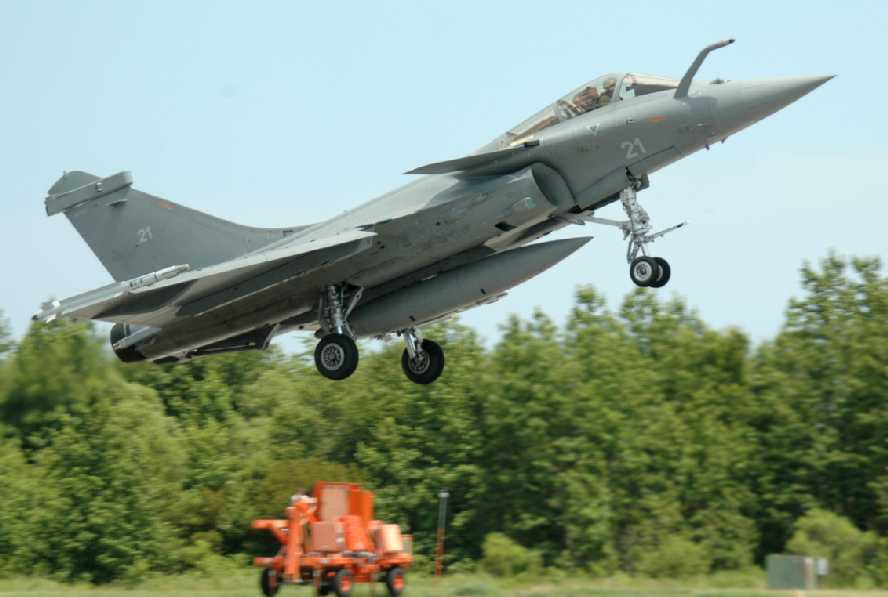
A July 2008 photo by NALF Fentress Crash Chief ABHC(AW/SW) Kris Smith of a French Navy Dassault Rafale M doing a touch & go at Fentress,
with the FLOLS gear in the background.
____________________________________________________
Since this site was first put on the web in 1999, its popularity has grown tremendously.
That has caused it to often exceed bandwidth limitations
set by the company which I pay to host it on the web.
If the total quantity of material on this site is to continue to grow,
it will require ever-increasing funding to pay its expenses.
Therefore, I request financial contributions from site visitors,
to help defray the increasing costs of the site
and ensure that it continues to be available & to grow.
What would you pay for a good aviation magazine, or a good aviation book?
Please consider a donation of an equivalent amount, at the least.
This site is not supported by commercial advertising –
it is purely supported by donations.
If you enjoy the site, and would like to make a financial contribution,
you
may use a credit card via
![]() ,
using one of 2 methods:
,
using one of 2 methods:
To make a one-time donation of an amount of your choice:
Or you can sign up for a $10 monthly subscription to help support the site on an ongoing basis:
Or if you prefer to contact me directly concerning a contribution (for a mailing address to send a check),
please contact me at: paulandterryfreeman@gmail.com
If you enjoy this web site, please support it with a financial contribution.
please contact me at: paulandterryfreeman@gmail.com
If you enjoy this web site, please support it with a financial contribution.
____________________________________________________
This site covers airfields in all 50 states.