Abandoned & Little-Known Airfields:
Central Virginia
© 2002, © 2016 by Paul Freeman. Revised 8/27/16.
____________________________________________________
Please consider a financial contribution to support the continued growth & operation of this site.
Clarksville-Finchley Airport (revised 10/6/15) - (Original) Culpeper Airport (revised 5/17/15) - Gordonsville Intermedidate Field (revised 5/6/13)
Burke Field / Hartman Field / Harrisonburg Airport / Shenandoah Airways Airfield / Blue Ridge Air Lines Airfield (revised 2/23/14) - Shenandoah Airport (revised 7/16/16)
South Hill Municipal (revised 6/15/14) - Staunton Aiport (revised 2/23/14) - University of Virginia Airport / Milton Field (revised 8/27/16) - Valley Airport (revised 2/23/14)
____________________________________________________
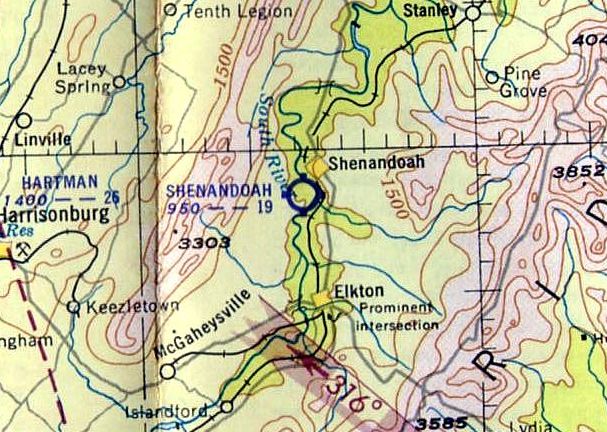
Shenandoah Airport, Shenandoah, VA
38.474, -78.627 (Southwest of Washington, DC)
Shenandoah Airport, as depicted on the 1953 Huntington Sectional Chart.
Photo of the airport while in use has not been located.
The date of establishment of this small general aviation airport to the southwest of the town of Shenandoah has not been determined.
The earliest reference to Shenandoah Airport which has been located came from Charles Jenkins: “It was there in the 1940s.
Dad said an Army Air Corps plane landed there with engine trouble. Dad said he caught rides there as a kid in the 1940s.”
However, Shenandoah Airport was not yet depicted on the 1949 USGS topo map.
According to Bill Fravel, “Shenandoah: I flew with my father (William E. Fravel) on this sod strip, first in a Cub & then a Luscombe.
My first flight was around 1951. The owner of the land had a Cessna.
I grew up at 723 9th Street & my father claimed he built our house so he could see planes using the field.
The field ran uphill from near the Shenandoah River with a tall stand of trees & had a small shack (where I read flying magazines),
a hangar for the Cessna & a sheetmetal windsock near midfield.
I heard a story that a Civil Air Patrol twin-engine plane once landed & ran out of strip & ended up in the swamp just shy of the road & a house across the street at the south end.
The State of Virginia filled in the swamp to extend the strip.
I have heard it called the strip at Rinacas Corner.
It was a farm belonging to the owner of the Cessna & he just made his own strip;
there was usually corn on both sides & he still had a road that crossed the strip, which mad for interesting landing in the tail-draggers.
If you still had a bit too much speed, it would put you airborne - get to log 2 landings!”
According to Debbie Burton, "Jennings Meadows owned the hangar where the plane was kept
and the little office was on property owned by my granddad Charlie Morrison.
He & Grandpa Meadows we called him owned the plane together - it would seat 2 adults & a child in back
and Everett Taylor owned the land where the landing strip was.”
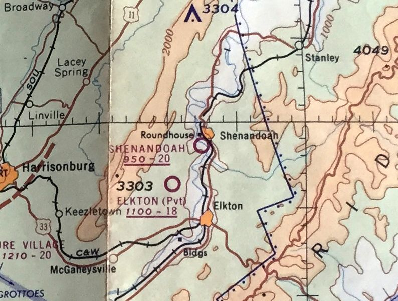
The earliest depiction which has been located of Shenandoah Airport was on the 1953 Huntington Sectional Chart,
which depicted Shenandoah Airport as having a mere 1,900' unpaved runway.
According to Bill Fravel, Shenandoah Airport “was there when I graduated from Shenandoah High School in 1961 & I believe still there in 1966.”
The last aeronautical chart depiction which has been located of Shenandoah Airport was on the July 1962 Huntington Sectional Chart.
It depicted Shenandoah Airport as having a 2,000' unpaved runways.
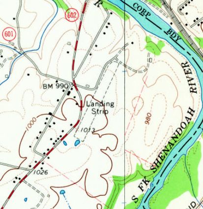
The 1965 USGS topo map depicted Shenandoah Airport as an unpaved northeast/southwest runway, labeled simply as “Landing Strip”.
There were no buildings depicted on the airport.
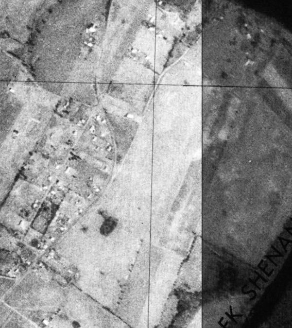
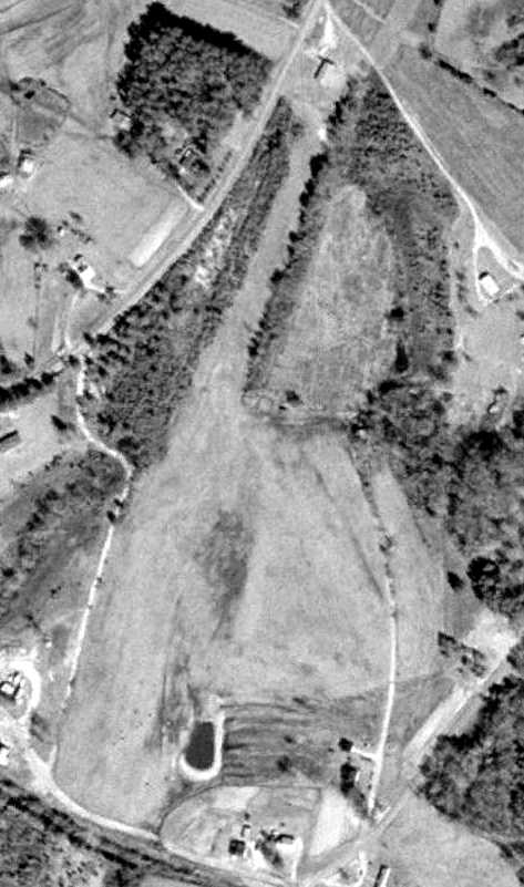
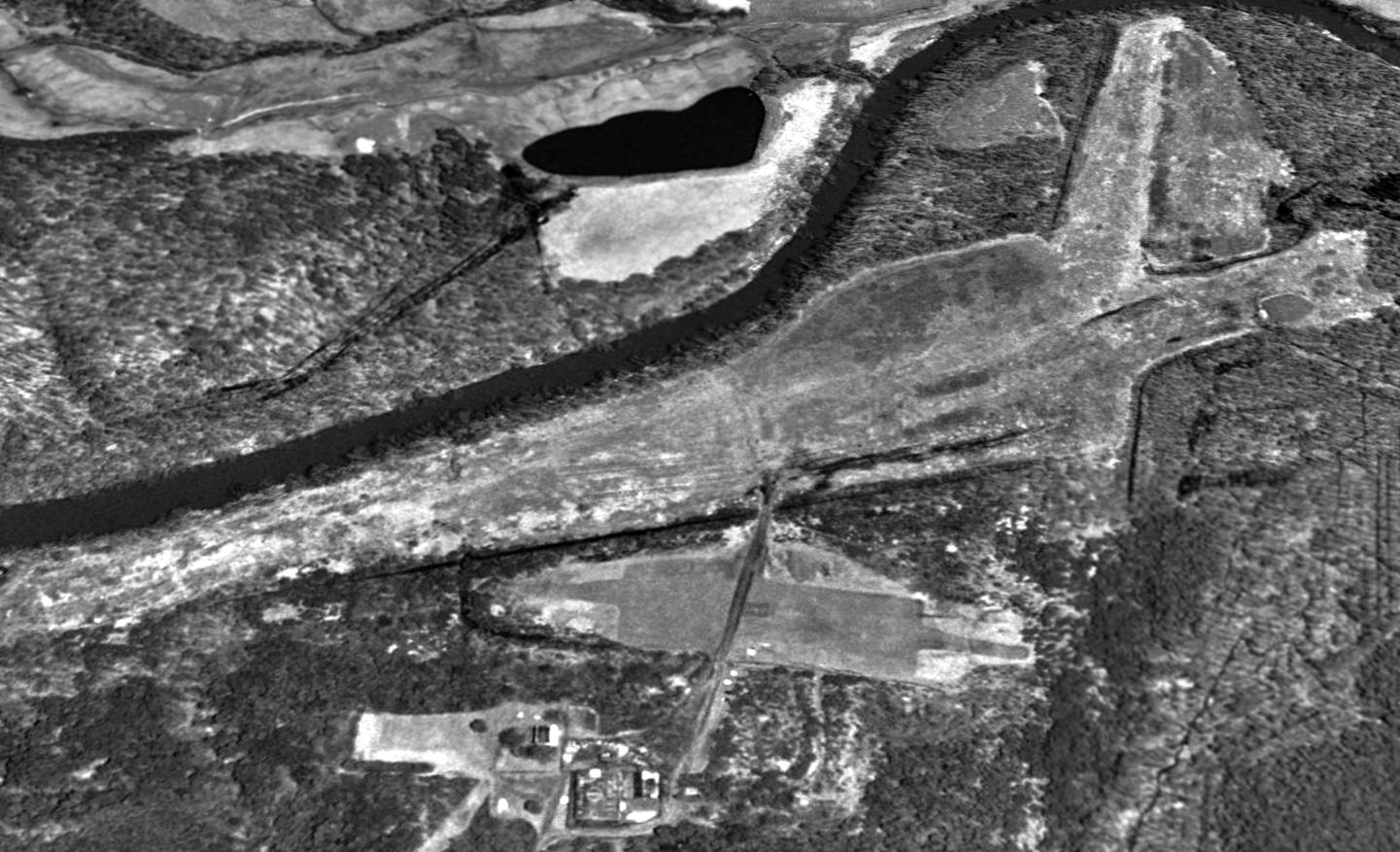
The earliest photo which has been located of Shenandoah Airport was a 1977 USGS aerial view.
Although the runway remained clear, there was no indication of any recent aviation usage.
The 1978 USGS topo map depicted Shenandoah Airport in the same fashion as the 1965 topo map.
According to Bill Fravel, “I believe the original owner sold the farm & the strip was just plowed back under.”
Shenandoah Airport was evidently closed by 1987, as the runway was no longer depicted on the 1987 USGS topo map.
According to Bill Fravel, “I was home for my 50th high school reunion [2011] and drove over there; I saw no trace [of Shenandoah Airport].
Where the hangar once stood is a farm animal feed lot.”
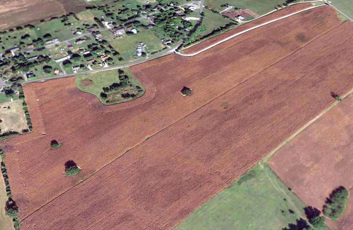
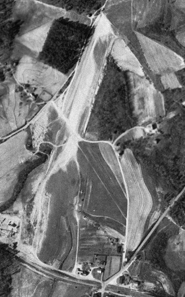
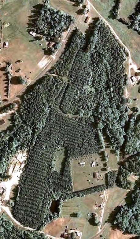
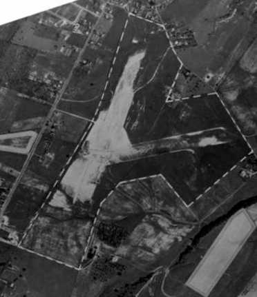
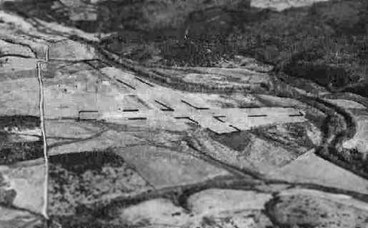
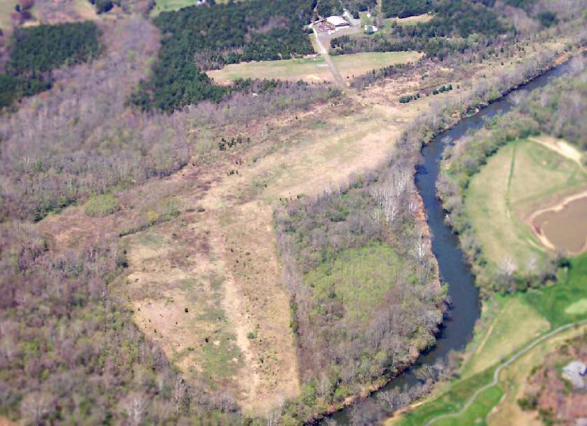
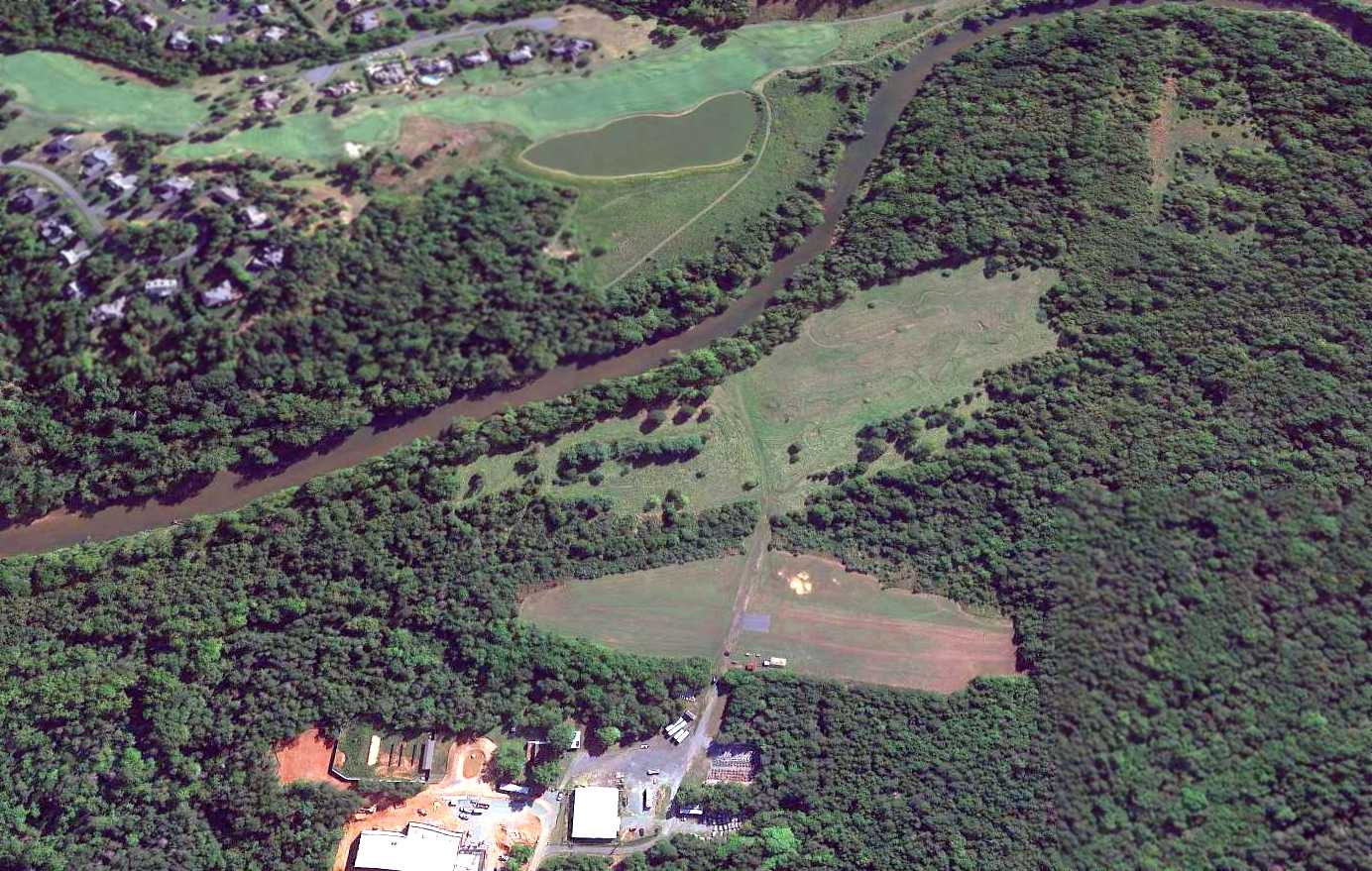
Amazingly a 2015 aerial view looking northwest still showed a recognizable outline of the Shenandoah Airport runway decades after it was abandoned.
The site of Shenandoah Airport is located southeast of the intersection of Route 602 & Route 947.
Thanks to Bill Fravel for pointing out this airfield.
____________________________________________________
Burke Field / Hartman Field / Harrisonburg Airport / Shenandoah Airways Airfield /
Blue Ridge Air Lines Airfield, Harrisonburg, VA
38.453, -78.878 (Southwest of Richmond, VA)
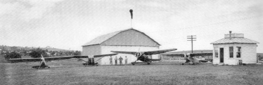
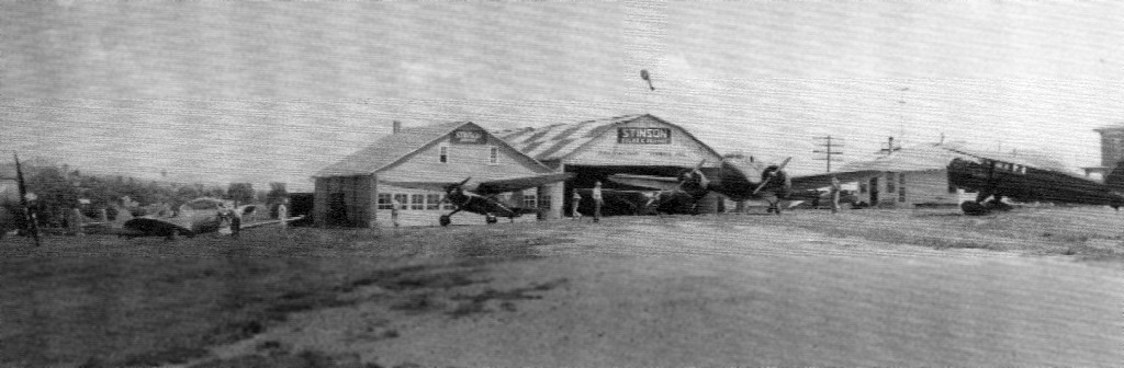
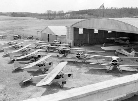
A circa 1941 photo of 4 planes in front of a hangar & office of Hartman Field.
According to the book “Hartman Airfield” by Randall Jones,
“In 1939 [Dan] Hartman leased a 44 acre family farm to establish an airport.
It was located northwest of Harrisonburg, just outside the city limits, situated between the town & the Mennonite community of Park View.
The land offered 360 degrees of good visibility.
He initially called it Burke Field, honoring the family from whom he leased the land,
although it was licensed as Hartman Field in November 1939.”
According to the book "Virginia Airports" by Vera Rollo & Norman Crabill (published by the VAHS),
“Hartman Field: The property was owned by John Burke.
Application for license made 10/23/39 by Dan Hartman & Joseph Koch.
License granted with restrictions 11/24/39.
This was a private-commercial, sod field with a 2,600' runway.
Operations began in December 1939. Operator/manager was John Dean.
Hartman operated Laird, Fleet, Standard, Pitcairn, Stinson, and Piper aircraft.”
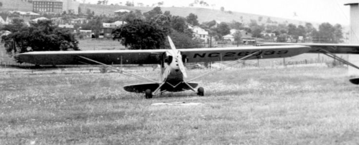
A closeup from the circa 1941 photo showing a Piper Cub at Hartman Field, with Eastern Mennonite College in the background.
Hartman Field was not depicted at all on the 1941 or 1943 USGS topo maps.
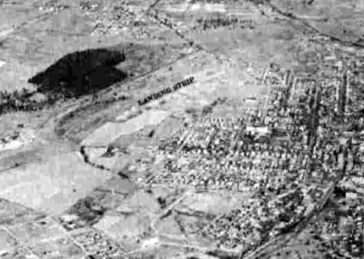
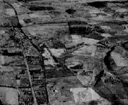
A circa 1942-45 aerial view looking north at Hartman Field (labeled “Landing Strip”) from the 1945 AAF Airfield Directory (courtesy of Scott Murdock).
The directory described Hartman Field as a 46 acre irregularly-shaped property
having a 2,200' stone & sod northeast/southwest runway.
Hartman was said to have 3 concrete block hangars, the largest measuring 60' x 46'.
The field was said to be owned & operated by private interests.
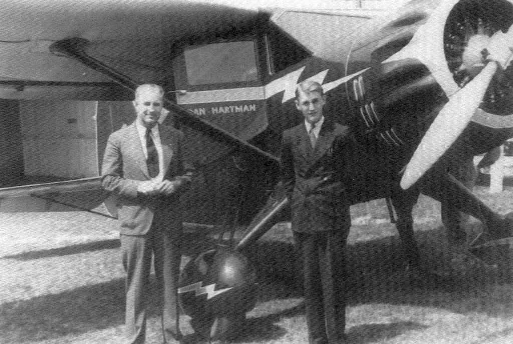
A circa 1946 photo of Dan Hartman & son in front of a Stinson (?) at Hartman Field.
A circa 1946 photo of a total of 6 planes in front of the hangars at Hartman Field.
According to Micheal McMurtrey, “The Cessna Bobcat may be s/n 5332, NC53799, purchased by Dan Hartman Airways Inc. in April 1946.”
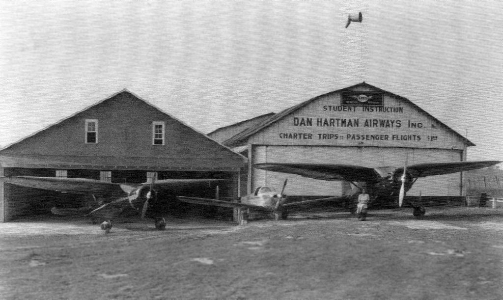
A circa 1946 photo Ottie Showalter (the Hartman Field office manager) sitting on the wheel of a Stinson Reliant, along with another Stinson & an Ercoupe, at Hartman Field.
Ned Swartz recalled, “Hartman Field: I remember my grandfather taking me to see airplanes at this site when I was about 2 or 3 –
one of the few memories I have at that age (about 60 years ago)!”
Perhaps the most exciting event at Hartman Field was an episode in the late 1940s or early 1950s, as described in the book “Hartman Airfield” by Randall Jones.
A Marine Corps F4U Corsair fighter made an emergency landing at Hartman
after another Corsair from its flight crashed elsewhere in Harrisonburg during stormy weather.
The next day a big Marine C-47 transport landed at Hartman bringing military accident investigators,
certainly the biggest plane to ever land at the tiny airport.
Jim Bentch recalled, “Dan Hartman’s Airport: It was still in operation in the early 1950s while I was still a child.”
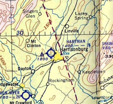
The only aeronautical chart depiction which has been located of Hartman Field was on the 1953 Huntington Sectional Chart,
which depicted Hartman as having a 2,600' unpaved runway.
According to the book “Hartman Airfield” by Randall Jones, Hartman Airfield closed in 1953.
It was eventually replaced by the much larger Shenandoah Valley Regional Airport, which opened in 1957.
A 4/6/63 USGS aerial photo showed that houses had covered much of the site of Hartman Field,
but a small portion of the runway remained in the center of the photo.
According to the book “Hartman Airfield” by Randall Jones, the subdivision covering most of Hartman Field was built in the 1960s & 1970s,
with Hartman Drive having been built directly over the runway.
The larger of the 2 hangars burned down in 1996.
As of 2006, the smaller hangar remained standing,
along with the airport office, which was expanded over the years & was reused as a consignment shop.
A 4/10/12 aerial photo showed no trace remaining of Hartman Field.
The site of Hartman Field is located at the intersection of Wolfe Street & Hartman Drive, appropriately enough.
See also: “Hartman Airfield” by Randall Jones.
____________________________________________________
Clarksville-Finchley Airport, Clarksville, VA
36.656, -78.493 (Southwest of Richmond, VA)
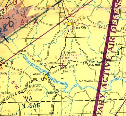
Clarksville-finchley Airport, as depicted on the March 1945 Winston-Salem Sectional Chart (courtesy of Dick Merrill).
Clarksville-Finchley Airport was evidently established at some point between 1937-45,
as it was not listed among active airfields in The Airport Directory Company's 1937 Airport Directory (courtesy of Bob Rambo).
The earliest depiction which has been located of Clarksville-Finchley Airport
was on the March 1945 Winston-Salem Sectional Chart (courtesy of Dick Merrill),
which depicted Clarksville-Finchley as an auxiliary airfield.
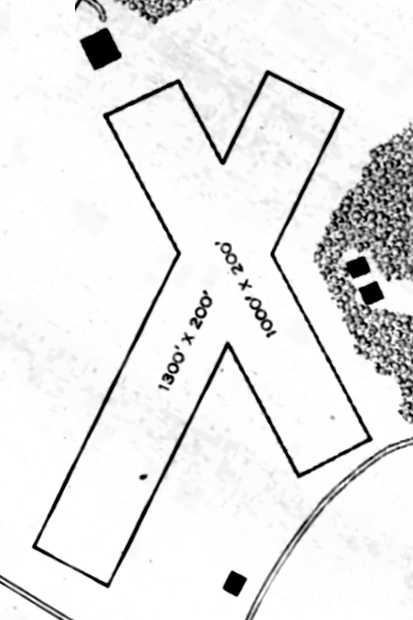
The 1945 AAF Airfield Directory (courtesy of Scott Murdock)
described Clarksville-Finchley Airport as a 35 acre irregularly-shaped property having 2 sod runways,
measuring 1,300' northeast/southwest & 1,000' northwest/sooutheast.
The field was said to have a single 58' x 40' wood hangar,
and to be owned by private interests, but “Not in operation” (presumably due to wartime restrictions).
According to the book "Virginia Airports" by Vera Rollo & Norman Crabill (published by the VAHS),
“Clarksville-Finchley Airport... was a turf field, a private-commercial operation.”
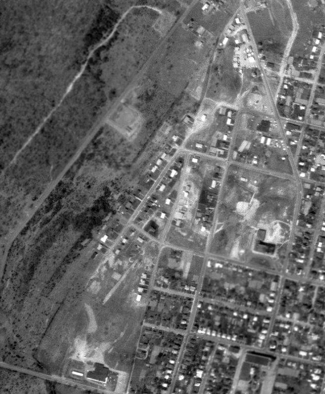
The only photo which has been located showing Clarksville-Finchley Airport in operation was a 3/17/54 USGS aerial view.
It depicted Clarksville-Finchley as having 2 unpaved runways, with one single-engine aircraft visible in the middle of the field.
The 1955 USGS topo map depicted Clarksville-Finchley as having 2 unpaved runways, labeled simply as “Airstrip”.
The 1968 USGS topo map depicted the “Airstrip” in an unchanged fashion.
Clarksville-Finchley Airport was evidently closed at some point between 1968-72,
as it was no longer depicted on the 1972 USGS topo map.
It was presumably replaced by the larger Marks Municipal Airport, which opened in 1961 a few miles to the southwest.
The 3/11/94 USGS aerial photo showed the 2 runways of Clarksville-Finchley Airport remained clear.
A building at the north end may have dated from the site's airport days.
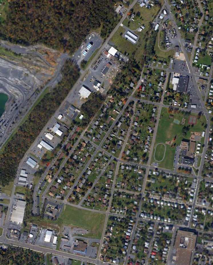
A 2003 aerial photo showed the site of the runways remained clear.
A 2007 aerial photo showed crops had been planted on the location of the runways.
A 6/20/11 aerial photo showed crops covering the location of the Clarksville-Finchley runways.
The site of Clarksville-Finchley Airport is located northwest of the intersection of Routes 58 & 703.
____________________________________________________
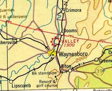
Valley Airport (original location), Waynesboro, VA
38.095, -78.87 West (Northwest of Richmond, VA)
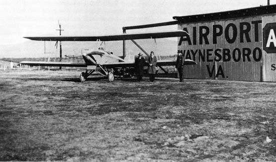
A circa 1931 photo of C. C. "Rip" Loth's 2-seat biplane at Waynesboro.
The date of establishment of the Valley Airport has not been determined.
The earliest reference which has been located to Valley Airport
comes from Clover Archer, curator of the Waynesboro Heritage Foundation,
who reported: “We have 2 artifacts relating to Valley Airport.
They are trophies that were awarded to Valley Airport at an Air Derby on October 12, 1928.
One of them says: 'Air Derby, Thompson Field, Oct 12-1928, Speed Race. Won By Valley Airport.'”
The earliest photo which has been located of Valley Airport
was a circa 1931 photo of C. C. "Rip" Loth's 2-seat biplane at Waynesboro.
The earliest airport directory listing which has been located of the Valley Airport
was in The Airport Directory Company's 1933 Airport Directory (according to Chris Kennedy).
It described Valley Airport as being located 1.75 miles northwest of the town of Waynesboro
(which may have described an earlier location, or it may have been in error).
which depicted Valley Airport as having 2 grass runways.
No hangars were depicted on the field.
The Airport Directory Company's 1937 Airport Directory (courtesy of Bob Rambo)
described Valley Airport as being located 1.75 miles northeast of the town of Waynesboro
(which agrees with later chart depictions of the field's location).
It described Valley as a commercial airport, consisting of a 50-acre sod field.
The field was said to have 2 runways in an “L” shape: 2,250' northwest/southeast & 2,000 northeast/southwest.
A 1937 photo of a Piper Cub at Valley Airport.
A 1937 photo of a Kinner Bird biplane at Valley Airport.
The earliest aeronautical chart depiction which has been located of the Valley Airport
was on the June 1939 Huntington Sectional Chart (courtesy of Chris Kennedy).
It depicted Valley as a commercial/municipal airport.
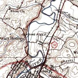
The 1939 USGS topo map depicted Valley as an irregularly-shaped outline, labeled “Landing Field”.
An undated aerial view looking north depicted Valley Airport as having 2 unpaved runways, with 11 light aircraft parked around a hangar on the east side.
No hangars were depicted on the field.
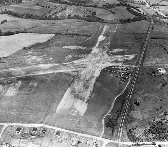
The last photo which has been located of the Valley Airport was a circa 1942-45 aerial view looking north
from the 1945 AAF Airfield Directory (courtesy of Scott Murdock).
The directory described Valley Airport as a 110 acre irregularly-shaped property
within which were 2 sod runways, measuring 2,600' NNW/SSE & 2,400' ENE/WSW.
The field was said to have 3 hangars, with the largest being a 94' x 60' cement block structure.
The airport was said to be privately owned & operated.
The November 1945 Huntington Sectional Chart (courtesy of Chris Kennedy)
depicted Valley as a commercial/municipal airport.
The last depiction which has been located of the original Valley Airport was on the 1953 Huntington Sectional Chart,
which depicted Valley as having a 2,900' unpaved runway.
The original location of Valley Airport was evidently closed at some point in 1953,
as Clover Archer (curator of the Waynesboro Heritage Foundation) reported,
“GE bought the property & built their plant there in 1953.”
A replacement Valley Airport was eventually opened at another location to the west of Waynesboro,
as the new field was depicted on the July 1954 Huntington Sectional Chart (courtesy of Chris Kennedy),
but the original airfield (to the northeast of the town) was no longer depicted.
As seen in a February 1, 2007 aerial photo,
the site of Valley Airport has been covered by a large industrial building (the GE plant),
and it does not appear as if any trace remains of the former airport.
The site of the original Valley Airport is located northwest of the intersection of Route 340 & Hopeman Parkway.
____________________________________________________
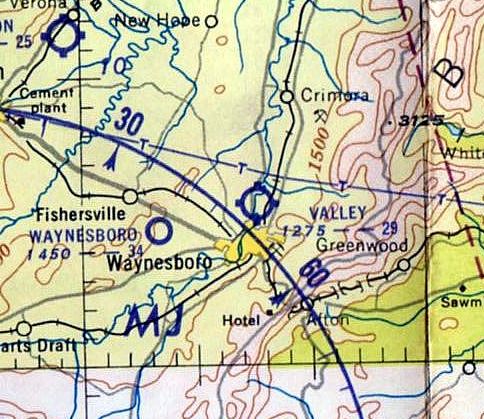
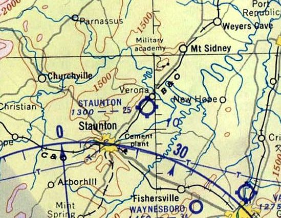
38.195, -79.01 West (Northwest of Richmond, VA)
Staunton Airport, as depicted on the June 1939 Huntington Sectional Chart (courtesy of Chris Kennedy).
The date of establishment of the Staunton Airport has not been determined.
The earliest reference which has been located to the Staunton Airport
was in The Airport Directory Company's 1937 Airport Directory (courtesy of Bob Rambo).
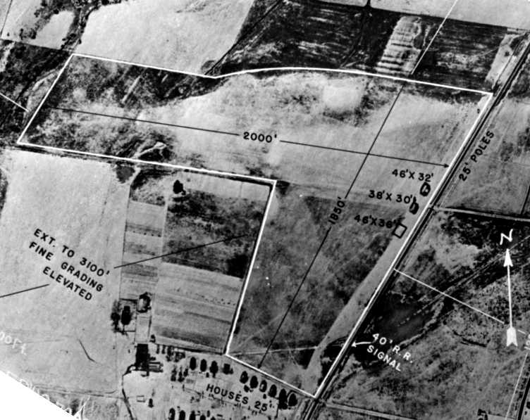
It described Staunton as an auxiliary airfield located 5 miles north of the town of Staunton, consisting of an 117 acre field.
The field was said to have 2 runways in a “V” shape, oriented east/west & north/south, with the longest being 2,630'.
The earliest depiction which has been located of the Staunton Airport
was on the June 1939 Huntington Sectional Chart (courtesy of Chris Kennedy).
It depicted Staunton as a commercial/municipal airport.
The earliest photo which has been located of the Staunton Airport was an 8/23/39 aerial view.
It depicted Staunton as having 2 unpaved runways.
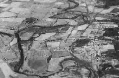
The last photo which has been located showing the Staunton Airport while it was operational was a circa 1942-45 aerial view looking northeast
from the 1945 AAF Airfield Directory (courtesy of Scott Murdock).
The directory described Staunton Airport as a 118 acre triangular property
within which were 2 sod runways, measuring 2,630' NNE/SSW & 2,100' east/west.
The field was said to have a single 80' x 68' metal hangar,
and to owned by the City of Staunton & operated by private interests.
The November 1945 Huntington Sectional Chart (courtesy of Chris Kennedy)
depicted Staunton as a commercial/municipal airport.
The last depiction which has been located of the Staunton Airport was on the 1947 USGS topo map.
It labeled the site simply as “Airport”, and did not depict any runways or property outline,
just an open area with a few small buildings along the edges.
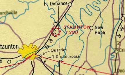
The Staunton Airport was evidently closed at some point between 1945-51,
as a 1951 aerial view looking northeast (courtesy of Willard Keeling) showed the the abandoned hangar of the former Staunton Airport
(marked with “Staunton” on the roof), with the remains of the runway in front, amidst the construction of the Westinghouse plant adjacent to the site of the airport.
Willard noted, “The picture was part of the estate of the former maintenance supervisor at Westinghouse.”
According to Willard Keeling, “The site of the Staunton Airport was used to build Smith's Transfer...
a very large trucking company that served the east coast from sometime in the 1950s until it closed in the later 1970s.”
Ironically the 1953 Huntington Sectional Chart continued to depict Staunton Airport,
even though it had been physically removed for at least 2 years by that point.
The Staunton Airport was no longer depicted at all on the July 1954 Huntington Sectional Chart (courtesy of Chris Kennedy).
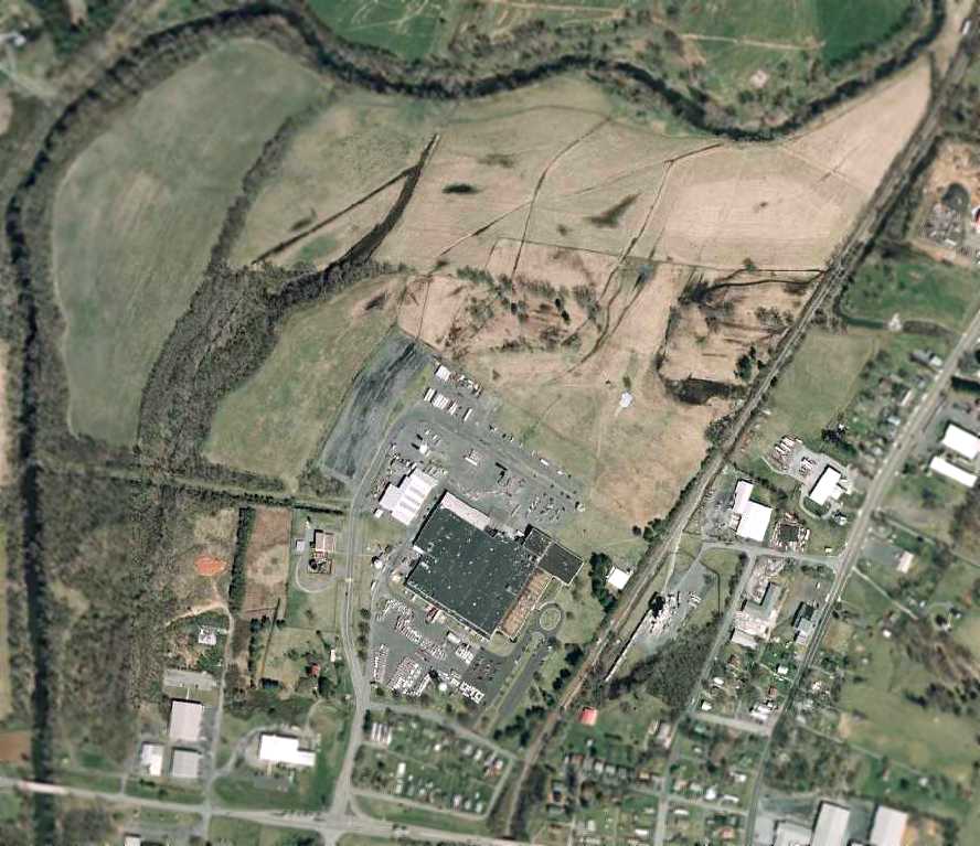
The 1998 USGS aerial photo showed that the site of Staunton Airport had been covered by several buildings,
and it did not appear as if any trace remained of the former airport.
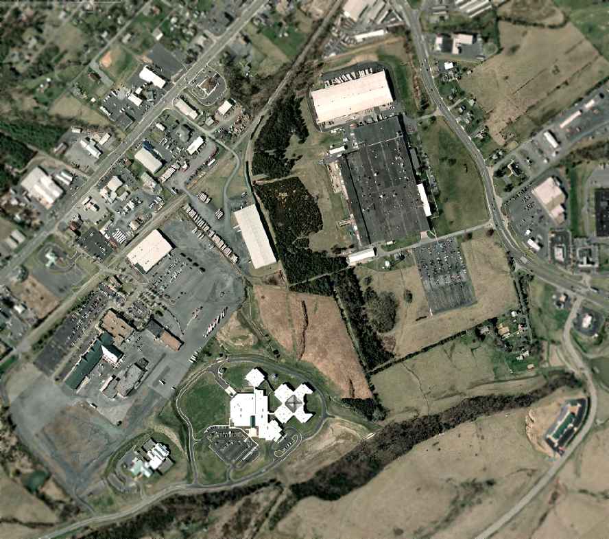
As seen in a February 1, 2007 aerial photo,
it does not appear as if any trace remains of the former Staunton Airport.
Willard Keeling reported in 2010, “The site now is the Augusta County Government Center
and no remains can be seen of the original airport use.”
The site of Staunton Airport is located south of the intersection of Route 11 & Laurel Hill Road.
____________________________________________________
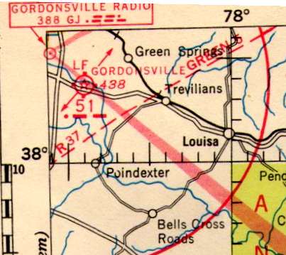
Gordonsville Intermedidate Field, Gordonsville, VA
38.065, -78.165 (Northwest of Richmond, VA)
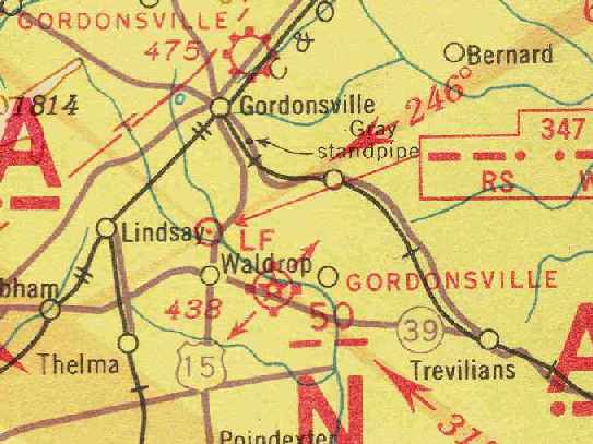
Gordonsville Intermediate Field, as depicted on the June 1939 Huntington Sectional Chart (courtesy of Chris Kennedy).
The Gordsonsville Intermediate Field was one of the network of fields established in the 1930s by the Department of Commerce
for the emergency use of commercial aircraft flying along airways between major cities.
The Gordsonsville Intermediate Field was evidently established at some point between 1937-38,
as it was not yet listed in The Airport Directory Company's 1937 Airport Directory (courtesy of Bob Rambo).
Note that the 1937 directory only described the Gordonsville Airport north of the town.
The earliest reference to the Gordsonsville Intermediate Field which has been located
was in The Airport Directory Company's 1938 Airport Directory (courtesy of Chris Kennedy).
It described the Gordonsville airfield (5 miles southeast of the town of Gordonsville)
as the Department of Commerce's Intermediate Field Site 50, along the Nashville-Washington Airway.
The field was said to have 2 sod runways in a T-shape, measuring 3,125' northwest/southeast & 2,250' northeast/southwest.
The field was said to have a hangar, but to offer no other services.
The earliest depiction which has been located of Gordonsville Intermediate Field
was on the June 1939 Huntington Sectional Chart (courtesy of Chris Kennedy),
which depicted it as Intermediate Field Site 50.
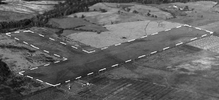
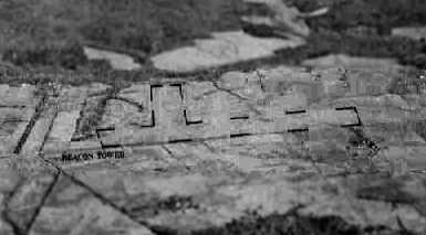
An October 1939 aerial view looking northeast at the Gordonsville Intermediate Field
(courtesy of the National Archives, photo # 18-LMU-08-829P).
The photo depicted the field as having 2 grass runways in a “T” shape,
with a rotating beacon across the road the south.
There were no hangars visible in the photo.
The 1945 AAF Airfield Directory (courtesy of Scott Murdock)
described Gordonsville Intermediate Field as a 70 acre T-shaped property
within which were 2 sod runways, measuring 3,125' WNW/ESE & 2,250' northeast/southwest.
The field was said to not have any hangars,
to be privately owned, but operated by the Civil Aeronautics Administration.
The April 1946 Norfolk Sectional Chart (courtesy of Jim Stanton)
showed that Gordonsville had been redesignated to Site 51 at some point between 1939-46.
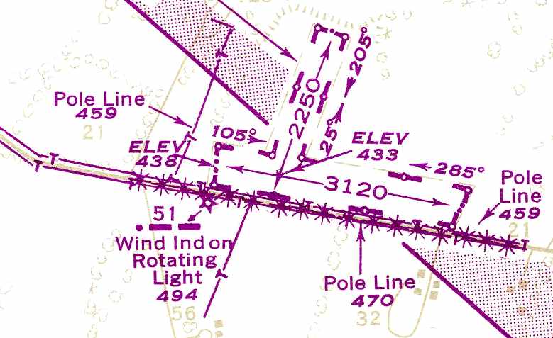
The 1948 USAAF Pilot's Handbook (courtesy of Chris Kennedy)
depicted the Gordonsville Intermediate Field as having 2 unpaved runways:
3,120' northwest/southeast & 2,250' northeast/southwest.
No buildings were depicted at the site.
The last depiction which has been located of the Gordonsville Intermediate Field as an active airfield
was on the January 1957 Huntington Sectional Chart (courtesy of Chris Kennedy).
It described the field as having 2 runways, with the longest being a 3,221' turf strip.
The Gordsonsville Intermediate Field was evidently abandoned at some point between 1957-58,
as it was no longer depicted at all on the May 1958 Huntington Sectional Chart (courtesy of Chris Kennedy).
This was longer than many of the other Intermediate Fields had lasted,
as their need had long ago been obviated by the advances in range & reliability of commercial aircraft.
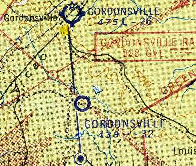
Nothing at the site of Gordsonsville Intermediate Field was depicted on the 1961 USGS topo map.
The 1994 USGS aerial photo showed the outlines of Gordonsville Intermediate Field's 2 former runways as still evident,
although divided up into separate fields.
It did not appear as if any of the buildings at the site dated from its days as an airfield.
As seen in a February 1, 2007 USGS aerial view,
the outlines of Gordonsville Intermediate Field's 2 former runways were still evident,
although divided up into separate fields.
It did not appear as if any of the buildings at the site dated from its days as an airfield.
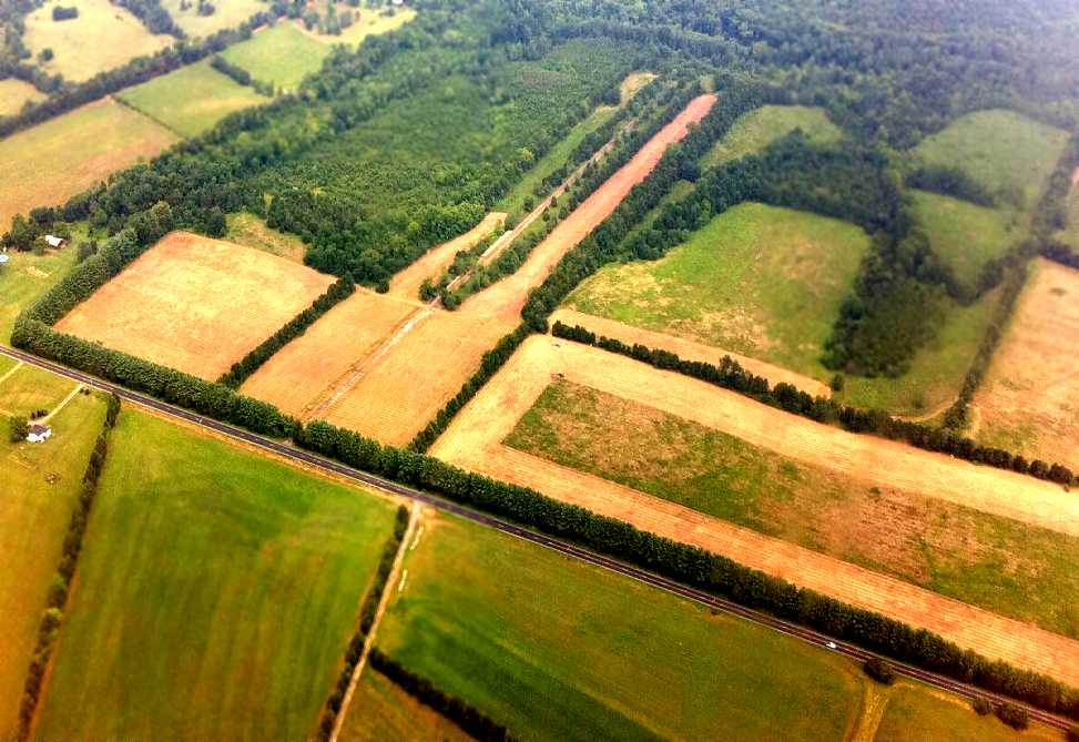
A July 2011 aerial view by Seth Cassaday looking north at the still-recognizable outline of Gordonsville Intermediate Field.
The site of Gordonsville Intermediate Field is located north of the intersection of Route 22 & Nolting Road.
____________________________________________________
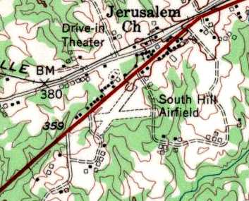
South Hill Municipal Airport, South Hill, VA
36.712, -78.167 (Southwest of Richmond, VA)
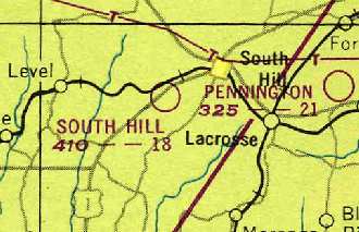
South Hill Municipal Airport, as depicted on the October 1948 Winston-Salem Sectional Chart (courtesy of Chris Kennedy).
The South Hill Municipal Airport was apparently built at some point between 1945-48,
as it was not depicted on the March 1945 Winston-Salem Sectional Chart (according to Chris Kennedy).
The earliest depiction of the field which has been located
was on the October 1948 Winston-Salem Sectional Chart (courtesy of Chris Kennedy).
It depicted South Hill as having an 1,800' unpaved runway.
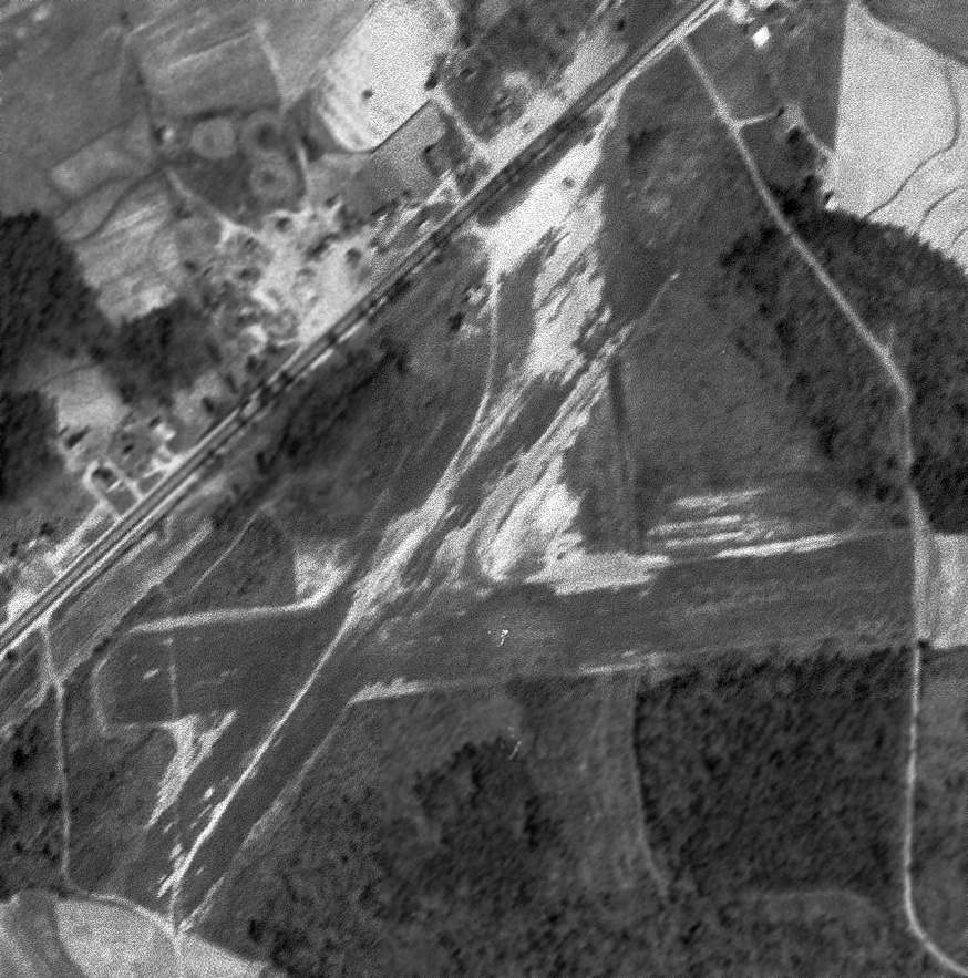
The earliest photo which has been located of South Hill Airport was a 3/17/54 USGS aerial view,
which depicted South Hill as having 2 unpaved runways in an “X”-shape.
What appeared to be 1 or 2 T-hangars were on the north side of the field.
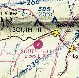
The 1955 USGS topo map depicted “South Hill Airfield” as having 2 unpaved runways in an “X”-shape.
South Hill apparently gained a paved runway at some point between 1955-62,
as the March 1966 Winston-Salem Sectional Chart (courtesy of Chris Kennedy)
depicted the field as having a 2,200' paved runway.
The 1970 VA Airport Directory (courtesy of Stephen Mahaley)
described South Hill Municipal Airport as having a single 2,000' paved Runway 4/22.
The outline of a former grass crosswind runway was also depicted.
Four small hangars were depicted along the northwest side of the runway.
The manager was listed as H. E. Bailey.
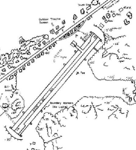
A September 28, 1973 aerial view by Kenneth Keeton looking southeast at South Hill Municipal Airport.
Several individual T-hangars were visible along the northwest side of the runway.
South Hill Airport, as depicted on the 1975 Washington Sectional Chart (courtesy of Ed Drury)
The 1979 Flight Guide (courtesy of Chris Kennedy) depicted South Hill Municipal Airport
as having a single 2,200' paved runway 4/22, with a ramp at the northern part of the runway, with 4 small buildings (hangars?).
South Hill Municipal Airport apparently was closed at some point between 1979-86,
as it was not listed in the 1986 Flight Guide (according to Chris Kennedy).
This was most likely due to competition from the new & larger Mecklenburg-Brunswick Regional Airport
which was built at some point between 1962-78, four miles southeast of the town of South Hill.
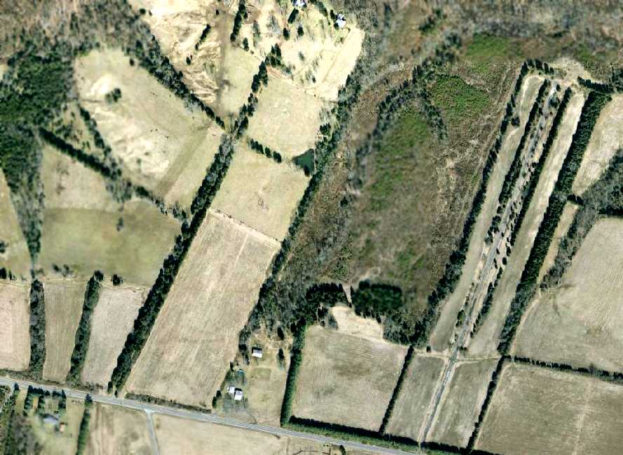
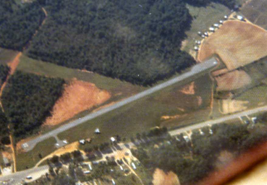
In the 1996 USGS aerial photo,
it appeared as if the former runway had been reused as a road (Montgomery Street)
in an industrial park which had been built on the site of the former airport.
A February 1, 2007 aerial photo showed the site of the former airport to be basically unchanged since 1996,
with the former paved runway still being reused as a road (Montgomery Street) in the middle of the industrial park.
The site of South Hill Municipal Airport is located south of the intersection of Route 1 & Bailey Road.
____________________________________________________
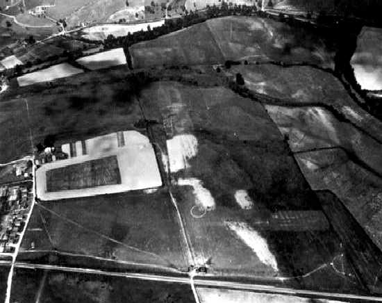
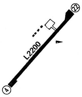
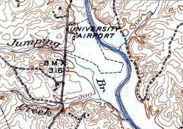
University of Virginia Airport / Milton Field, Milton, VA
37.995, -78.395 (East of Charlottesville, VA)
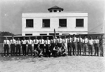
An undated photo of the University's fleet of training aircraft in front of Milton Field's hangar (courtesy of Rick Harshbarger),
with a total of 13 aircraft visible outside & inside the hangar (including Piper Cubs & unidentified biplanes).
Also known as Milton Field, the airport of the University of Virginia was located along the west bank of the Rivanna River,
east of Milton Road, one mile south of Milton, VA.
The University's airfield was Central Virginia's first & only commercial airport for many years.
No airfield was visible at this location on a 5/4/37 aerial photo.
According to an article by Maura Singleton in the University of VA Alumni Association Magazine (courtesy of Mark Harvey),
in 1939, the University's move to buy Hughes River Farm along the west bank of the Rivanna River
stirred the ire of residents in the surrounding agrarian communities of Milton, Shadwell & Keswick.
The prospect of low-flying aircraft piloted by young guns from the local university posed untold hazards.
The property, owned by W.D. Hayden, had in fact originally been part of Thomas Jefferson's 5,000-acre plantation,
and was possibly one of the sites of his water-powered manufacturing enterprises.
The University, which already offered students ground training in aeronautics,
had a compelling reason for wanting to build an airfield.
The Civilian Pilot Training Program, a government-sponsored program
designed to provide a pool of civilian pilots for military service, was newly launched.
Hitler had just invaded Poland; the threat of involvement in the war loomed large.
Lawyers for the property owners association shared their gripes at an October 20, 1939
hearing by the State Corporation Commission in Richmond, where they delivered their trump card, to wit:
Mr. Jefferson did not allow for an airport or a school of flight in the University's 1812 charter.
The SCC judges weren't swayed.
Commercial license in hand, the University purchased the 90 acres of level floodplain for $17,800
and cleared the cornfields for 2 crisscrossing runways, oriented north/south & east/west, plus a 3rd short north/south runway.
It would seem that big things were expected: the dedication ceremony on 4/28/40 attracted a crowd of 2,000 people.
The usual formalities - the local chapter of the Daughters of the American Revolution presented a flag to the University,
the dean of engineering gave a speech - were interrupted by the unexpected & dramatic arrival of one of the SCC judges,
who touched down in a Stinson Reliant.
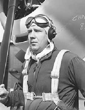
An undated photo of Walter "Roy" Franke.
That the University undertook such a project was due to the energies & talents of 2 men:
Frederick Morse & Walter "Roy" Franke. Both were aviators.
Morse chaired the Department of Mechanical Engineering,
and Franke was a structural engineer & part-time instructor for U.Va.
Morse & Franke developed the first wind tunnel at the University.
If both men were born to fly, they were also born teachers.
Morse became the director of the University's Civilian Pilot Training Program & headed the ground school.
As second in command, Franke was the flight operations director & essentially ran the airport.
The flight school moved into high gear almost immediately.
The first pilot training class began in November 1939.
Lasting 4 or 5 months, each class enrolled 30 students.
That schedule became more compressed when the U.S. entered the war,
with a new class receiving pilot certification every 2 months.
In late 1940, with a $21,000 grant from the Works Progress Administration, the University expanded Milton Airport.
The runways were extended, a new & larger hangar was constructed, and a 2-story cinderblock administration building was built.
Most students learned on the Piper Cub J-3, which was considered the "Model T" of aviation -
cheap, easy to fly, and forgiving on landings.
With a gross weight of 1,220 pounds, and a maximum speed of 85 mph,
the Cub was an excellent trainer, requiring only 800 feet of takeoff room.
An instructor strapped himself into the seat as students learned rolls,
forced landings, figure eights, stalls, spins & steep power turns.
For advanced training, students flew the T-6 Texan.
Designed to prepare pilots to fly bombers & fighters,
this aircraft could roll, loop, spin & snap, and gave training in all types of tactics,
from ground strafing to bombardment & aerial dogfighting.
To earn their wings, students had to complete 72 hours of a ground course that included classes in meteorology,
theory of flight, engines, instrumentation, elementary air navigation & civil air regulations.
The flight course called for a minimum of 17 hours with an instructor & 18 hours solo.
"For extra flying time, students could hop on a tractor & bush hog the airfield,"
recalls Fritz Franke, Roy Franke's son.
The Airport Directory Company's 1941 Airports Directory (courtesy of Chris Kennedy)
described the University of VA Airport as having 2 sod runways: 2,400' north/south & 1,800' east/west.
The field was said to have hangars.
The "University of VA" was depicted as a commercial airport
on the September 1941 9M Regional Aeronautical Chart (courtesy of Chris Kennedy).
When the U.S. became involved in World War II,
the Army & Navy took over existing airfields such as Milton Airport
to groom pilots until their own training centers could be built.
During this period of intensive training, the staff of ground & flight instructors & service personnel numbered almost 25.
A Civil Air Patrol squadron was established by Frederick Morse at Milton Field during WW2.
The University of VA Airport was described in the 1944 US Army/Navy Directory of Airfields (courtesy of Ken Mercer)
as having a 3,500' runway.
A circa 1942-45 aerial view looking north at the UVA Airport from the 1945 AAF Airfield Directory (courtesy of Scott Murdock)
depicted the field as having 2 grass runways.
The directory described UVA Airport as a 178 acre irregularly-shaped property
within which were 2 clay & loam runways, measuring 3,500' north/south & 2,500' WNW/ESE.
The field was said to have 2 hangars: 150' x 80' metal, and 60' x 40' wood.
The airport was said to be owned by the State of VA, and be privately operated.
The 1945 Haire Publishing Company Airport Directory (courtesy of Chris Kennedy)
described the University of Virginia Airport as having 2 sod runways
(with the longest being a 3,500' north/south strip),
and said that the field also had a single 80' x 100' hangar.
It listed the operator as Virginia Cub Distributors,
and listed the manager as W. R. Franke.
After the war, the University's flying field continued in its dual capacity as a commercial airport,
but the University's interest in its own airport started to decline.
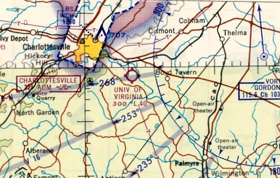
The "University of VA" was depicted as a commercial/municipal airport
on the March 1945 Winston-Salem Sectional Chart (courtesy of Dick Merrill).
The 1946 USGS topo map depicted the “University Airport” as having an irregularly-shaped outline,
with 3 buildings along the northwest side.
In 1948 the Board of Visitors granted permission to lease the airport,
but urged University officials to dispose of the property as soon as possible.
At one time, the University's fleet included a Grumman Wildcat, a Spartan NP-1, and a couple of Stinsons.
When faculty needed to attend conferences around the state,
they sometimes used Frederick Morse's 4-passenger plane, nicknamed the "Blue Goose",
or a Beechcraft 18, a World War II military aircraft that was reconditioned for use as executive transport.
The Beechcraft was declared surplus by the University just a year after its purchase,
however, because of the lack of licensed pilots to fly it.
Business at Milton Field began to dwindle with the opening of the Charlottesville-Albemarle Airport,
eight miles north of town, in 1955.
The engineering school used a single-engine Stinson Voyager
to teach an undergraduate lab course, but that, too, was eventually stopped.
"The students flew as passengers & did measurements.
They were like flight-test engineers," says George Matthews, a professor emeritus of aerospace engineering.
"That course got deleted in the mid-1960s due to growing liability concerns.
The plane was sold, and U.Va. didn't buy any more."
The Civil Air Patrol squadron which had been established during WW2 continued in peacetime.
Reid, who served as Morse's adjunct, recalls that the club was a mix of students, faculty & local citizens.
"We were involved in search & rescue missions in the area," he says.
"We got called a lot, because there was no organized air activity then for missing aircraft."
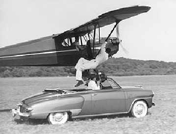
An undated photo of a stunt act at Milton Field,
in which a stuntman climbed up from a moving car into a Piper as it flew along the runway.
The crowds that came to the airport now came as spectators for the Sunday afternoon aerobatic shows.
Helmetless men performed maneuvers the likes of which, these days, seem downright rash -
wing walking, hanging precariously upside down from a plane's strut to snatch an object from the ground.
Another popular stunt involved racing a convertible the length of the landing strip,
from which a rider was plucked by a low-flying plane.
A 6/20/57 aerial view depicted UVA Airport as having 2 grass runways, with a few hangars & 2 light planes on the northwest side.
Bob Somers conducted flight instruction at the University of Virginia Airport in a red & white Aeronca 7AC in 1959.
The UVA Airport was listed among active airports in the 1962 AOPA Airport Directory,
with a single 3,800' turf runway (18/36), and the operator listed as J.W. Taylor.
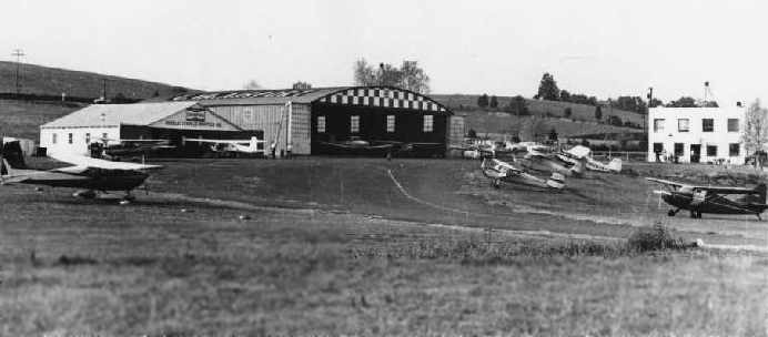
A 1962 picture in the book "Virginia Airports" by Vera Rollo & Norman Crabill (published by the VAHS)
depicted the UVA Airport as having a large arched-roof hangar, a smaller hangar, and a 2-story office building.
The
University's last plane was sold off in the mid-1960s.
From the time of its dedication to the end of its commercial use, Milton Airport had a life span of a mere 25 years.
Roy Franke continued to lease the airport for a number of years
and serviced private planes before turning over the lease in 1964 to 2 partners,
a local businessman & a judge.
A few flying & parachuting clubs used the field, but otherwise the partners didn't have much success.
A 4/23/64 USGS aerial view depicted one twin-engine plane parked next to the Milton Field hangar.
The last aeronautical chart depiction which has been located of University of VA Airport
was on the October 1965 Winston-Salem Sectional Chart (courtesy of Ron Kunse).
It depicted UVA Airport as having a 4,000' unpaved runway.
A 12/4/66 aerial view depicted 3 light planes on the field.
The 1968 VA Airport Directory (courtesy of Don Thompson) described the UVA Airport
as having 2 grass runways, and listed the operator as Charlottesville Aviation Inc.
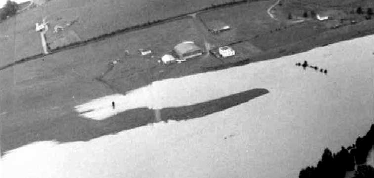
with water covering the entire runway area, with the hangars & office building just having been spared from being inundated.
A single plane was located next to the hangar.
At some point between 1968-70, the airfield was apparently renamed "Monticello",
as that is how it was labeled on the 1970 Washington Sectional Chart (courtesy of John Clifford).
In the UVA Airport's latter years the operator was Horizon Aviation,
which also ran a fixed-base operation at Charlottesville Airport (according to the book "Virginia Airports").
Milton Field officially closed in 1971,
according to an article in the University of VA Alumni Association Magazine (courtesy of Mark Harvey).
However, Monticello Airport was still depicted as an active public-use airfield
on the 1973 Washington Sectional Chart (courtesy of Mike Keefe),
and it wasn't until 1974 that the operating license for the UVA Airport was canceled,
according to the book "Virginia Airports".
A 10/6/74 aerial view showed the airport remained intact, but no aircraft were visible on the field.
By the time of the 1975 Washington Sectional Chart (courtesy of Ed Drury),
the airport was no longer depicted at all.
Over the subsequent years, Milton Airport has become a kind of anomaly,
serving every purpose except its original one.
A hay farmer leased it briefly, then for 10 years it functioned as a tree farm.
A 1992 aerial photo in the book "Virginia Airports" showed that the area around the hangars had become thickly wooded.
This is in stark contrast to photos of the same area from the 1960s,
when then area around the hangars was an open grassy area.
The airport made a brief news splash in the early 1990s
when volunteers with the Virginia Canals & Navigation Society found a 60' long bateau, intact,
stuck in the riverbank on the property.
Before a flood swept it away, archeologists were able to date it to Jefferson's time,
and guessed that its machine-made nails were probably made in Monticello's shop.
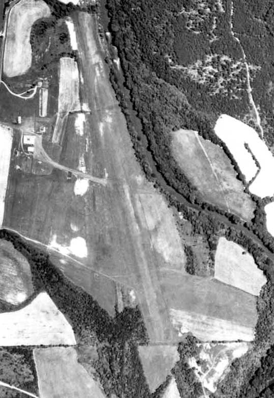
A 1994 USGS aerial view looking east at UVA Airport showed the airport & its hangar remained intact though deteriorated,
although a grass area just east of the hangar had been newly cleared for radio-controlled model aircraft operation.
In a 1994 report by the state Joint Legislative Audit & Review Committee,
the Milton Airport property was declared surplus by the University,
and was included among state-owned properties that could be put up for sale.
In 1995, when word spread that the University was considering disposing of the airport, interest was reawakened.
The nearby Clifton Inn made inquiries, considering the property for a sports complex.
Albemarle County also looked into acquiring it for recreational use,
its flat runways well suited for soccer or softball fields.
Even the state Department of Corrections made a site inspection.
The fact that most of the property lies in a floodplain (less than 35 acres are developable) has kept its prospects modest.
But perhaps more formidable than its topography has been the opposition of local landowners.
Just across the Rivanna River is the private, gated golf community of Glenmore,
whose residents have thwarted such schemes.
Monticello, too, has followed various proposals with particular concern
because the property is situated within its "viewshed."
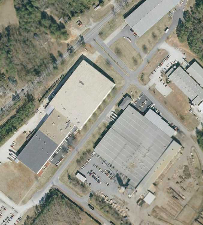
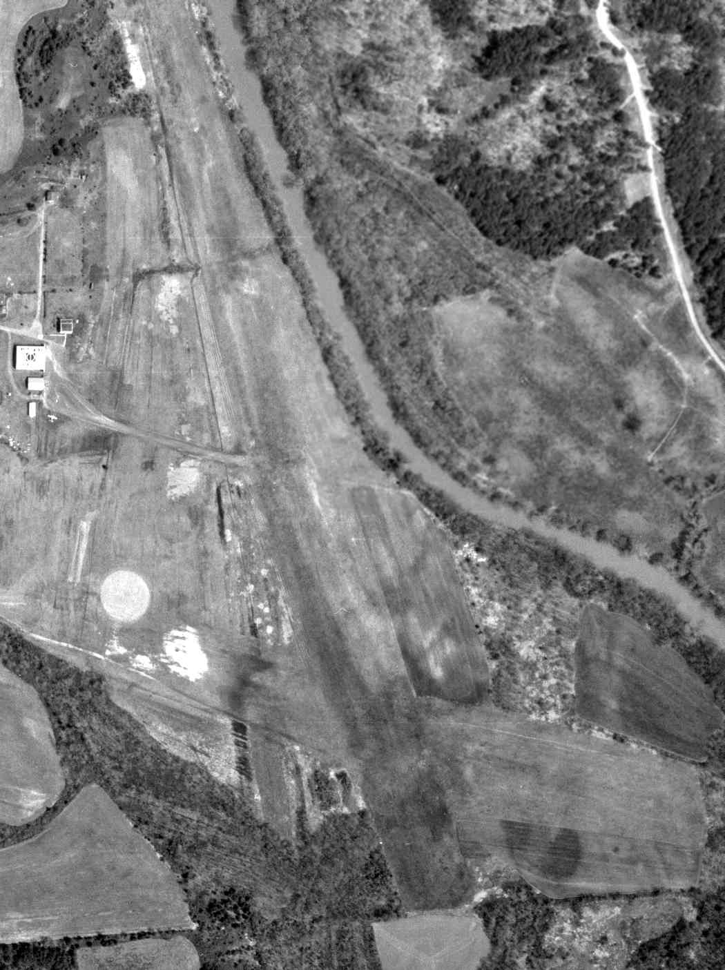
Aerial view looking west, taken from a Diamond Katana DA20-C1, by Paul Freeman, 2002.
The larger hangar still remained standing,
but the cleared areas of the former runways were becoming overgrown.
The former airfield was no longer depicted at all (even as an abandoned airfield)
on the 2002 Washington Sectional Chart.
As of 2003, local law enforcement agencies use part of the former airport property as a shooting range
and for training exercises involving dogs.
The U.S. Army ROTC likes the varied terrain for field training drills.
The U.S. Air Force maintains an air monitoring station there as part of the Comprehensive Test Ban Treaty,
measuring radionuclides in the atmosphere.
Franke, who keeps a watchful eye over the property while doing environmental research & computer work there,
is also the station's operations technician.
The former hangar has been used to store thousands of folded graduation chairs,
along with recycling containers & snow-removal equipment.
As of 2003, there is still flying taking place, albeit of different dimensions.
The amateur Rivanna Radio Airplane Club uses the short runway
in exchange for keeping the area free of trash & the grass mown.
Their weekend air shows have an avid following.
On the other runways, U.Va. students fly a solar-powered airship,
which is also kept in the former hangar.
Although Milton Field was still listed by the University as surplus property,
it hasn't yet been sold (as of 2003).
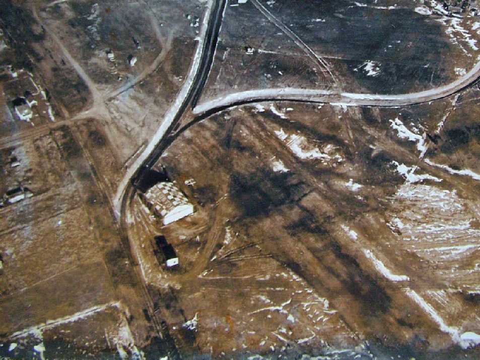
A circa 2010 aerial view looking west at Milton Field showed the larger hangar still remained standing,
with “UVA Airport” still recognizable painted on both sides of its roof.
Fritz Franke reported in 2015, “UVa Airport... It is being used a lot by the Architecture School & Engineering School.
They conduct classes, workshops, and events out there. They basically have taken over the entire hangar.
Plus, there's now a huge facility that is an indoor firing range supporting the UVa, Albemarle county, and Charlottesville police departments.
With the Rotunda being renovated, the airport is being used as a storage/staging area for the project.
There's a new area that now houses the inventory for brick, slate, and stone for all of the historic buildings on the lawn.
There is also talk of building some warehouses out there.
And with all this activity happening, all the buildings are being fixed up & modernized.”
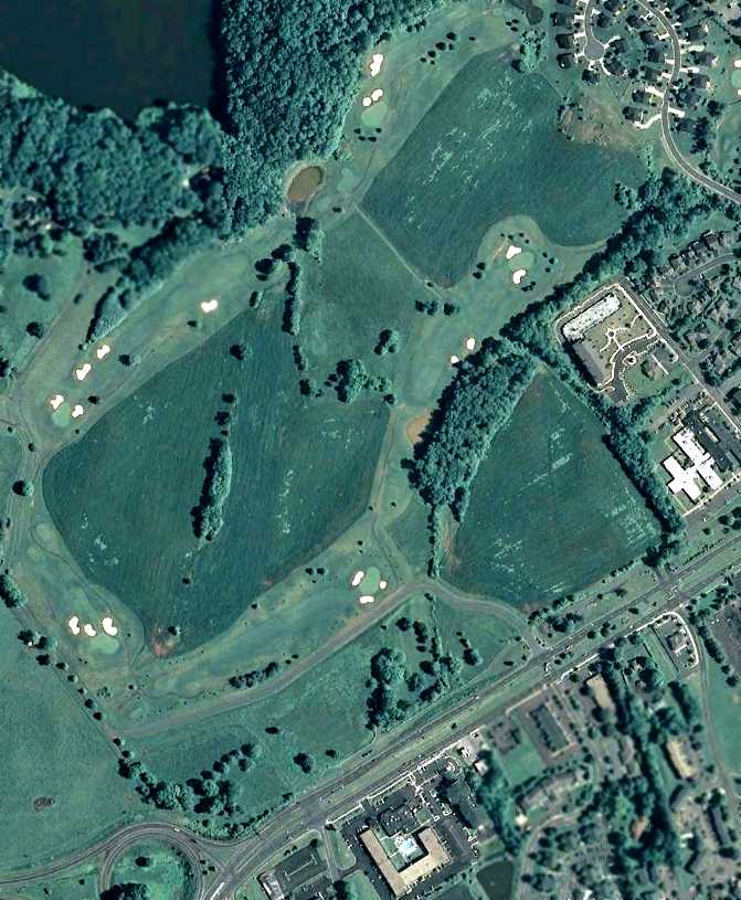
A 2015 aerial view looking east at Milton Field showed the site was no longer recognizable as a former airport,
with trees having filled in the area of the 2 former runways.
The sole remnant of the airport was the hangar which still remained on the west side (bottom-center), but a new building was being constructed to the north of it.
Thanks to Charles Robertson for pointing out this field.
____________________________________________________
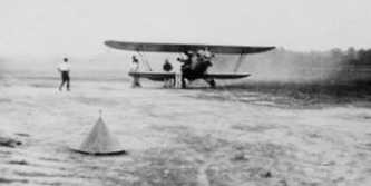
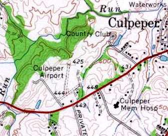
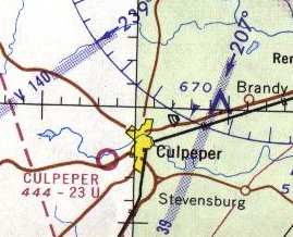
Original Culpeper Airport, Culpeper, VA
38.46, -78.022 (Southwest of Washington, DC)
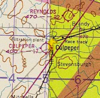
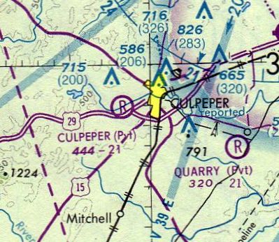
The original Culpeper Airport, as depicted on the 1947 Washington Sectional Chart.
The original Culpeper Airport was opened in 1946,
when Peter Jarvis leased land from Tom Cline along Route 29 across from the current Holiday Inn
a mile or so southwest of the town of Culpeper.
According to the book "Virginia Airports" by Vera Rollo & Norman Crabill (published by the VAHS),
Jarvis' applied for his operating license for the airfield on 1/29/46,
and it was approved on 6/12/46.
Jarvis hoped his airport could realize significant income from G.I. Bill students,
but that never really materialized, and it was in financial trouble within several years.
The 1947 Washington Sectional Chart depicted Culpeper as having a 1,700' unpaved runway.
A number of tenants & students banded together to form the Culpeper Flying Club,
later the Culpeper Flying Corporation, to keep the field & their flying going.
Bill Carpenter (who had flown out of Lindsey’s farm in the 1930s) led the group,
operated the field & became even more of a Culpeper aerial legend.
Bill owned several aircraft throughout his career,
but usually flew his Piper PA-11 Cub which has been in the family for several decades.
In its early career, NC 4854M graced the cover of the March 1948 Flying Magazine
(which sold for 25 cents at the newsstand).
He bought it from the Reeds when they needed cash to make one of the airport payments to Jarvis.
One of Bill’s favorite tricks was to go up on a windy day, fly up Main Street,
throttle back to near idle & drift backwards or just "hover" over Main & Davis.
Of course he would land on any field or meadow,
but then getting somewhere on the ground was a chore.
So he made a rig & mounted a small motor-bike outside on the right side of the fuselage
and he would putt-putt to wherever he needed to go after landing.
Back then the rules weren’t so stiff.
Nearly 20 planes were based at a time at the old Culpeper field,
and some 90 airplanes were based there over a 30 year period after WW2,
including Cessna, Pipers, Beechcrafts, Culvers, Luscombes, Bellancas, Stinsons, and Swifts.
But the Culpeper field wasn’t very big.
Initially Runway 6/24 was only 1,600', with a bit of a grade on 24, although it was 300' wide.
In 1947, a crosswind Runway 1/19 of a whopping 2,150' was constructed, albeit only 200' wide.
These were fine for Luscombes & Pipers, but it was a tight squeeze for some of the "hotter" aircraft.
T. I. Martin, long-term Mayor of Culpeper (and for whom the replacement airport was later named)
happened to be at the field one day when golfer Arnold Palmer landed his Aero Commander.
With the brakes locked & the wheels sliding over the grass,
Palmer's Commander stopped "within inches" of the far end.
After stepping out, Palmer turned to Martin & just said, "Damned short strip", and went off to his game.
Bill Carpenter’s son, Glen, claims he also once saw a twin Beech squeeze into the strip
and watched thirteen people (admittedly some children) clamber out.
He said it looked like the Volkswagon in a circus & you could see the shock struts expand as they deplaned.
Surprisingly, considerable night flying was done, even though the field was initially unlit.
Some boundary lights were later installed on Runway 6/24.
The 1949 Washington Sectional Chart (courtesy of Mike Keefe)
described Culpeper as having a 2,900' unpaved runway.
Peter Jarvis sold the field in 1949 to Harry Lehman & Frank & Evelyn Reed
(who had previously operated Beacon & Hyde Fields),
but he had to repossess it in 1950 after payments fell behind.
However, Jarvis died prematurely from a sudden heart attack in 1951.
Merton Meade recalled “The old Culpeper field was a lot of fun.
Very nice grass & the Holiday Inn across the street was where we usually had lunch.”

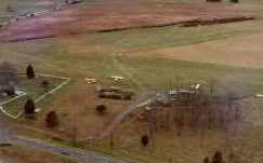
A circa 1950 aerial view of the original Culpeper Airport.
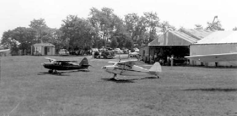
A circa 1950 view of the ramp area at the original Culpeper Airport.
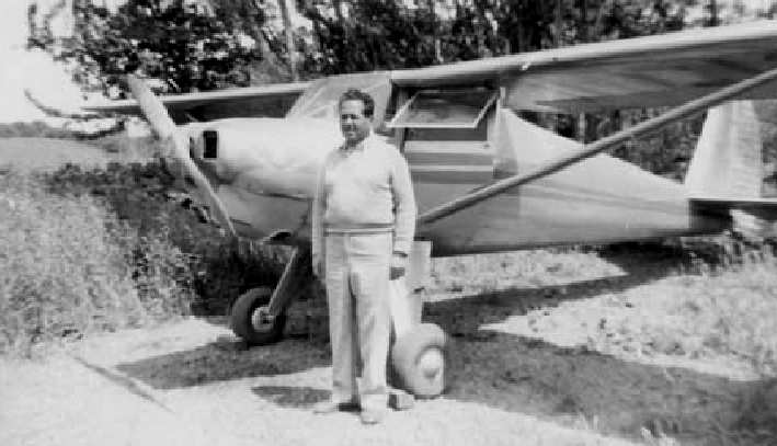
Peter Jarvis & his Luscombe at the original Culpeper Airport.
The runway length had been reduced on the 1951 Washington Sectional Chart (courtesy of Mike Keefe),
which described Culpeper as having a 2,300' unpaved runway.
A 2/25/59 USGS aerial view showed the original Culpeper Airport to have 2 grass runways, with a building & 3 single-engine planes at the southeast end.
The original Culpeper Airport, as depicted on the 1961 USGS topo map.
The 1962 AOPA Airport Directory described the field as having 2 turf runways:
2,300' Runway 1/19 & 1,700' Runway 5/23.
The operator was listed as Culpeper Flying Service.
The original Culpeper Airport was depicted on the 1964 Washington Sectional Chart (courtesy of John Voss)
as having a 2,300' unpaved runway.
An 11/22/69 USGS aerial view showed the original Culpeper Airport to have 2 grass runways, with a building & 10 single-engine planes at the southeast end.
Perhaps more surprisingly, but maybe not so much given the caliber of those running the operations & training,
there were few incidents or crashes at the field; none of the latter by residents.
But as the town grew, there was clearly a need for a bigger & paved field.
The old field was surrounded & couldn’t really be enlarged.
A site for a new Culpeper Airport was selected at Elkwood, about 6 miles northeast of Culpeper,
and the new T. I. Martin Culpeper Municipal (later County & still later Regional) Airport opened in 1969.
The original Culpeper field continued in operation for a few more years.
It was still depicted on the 1973 Washington Sectional Chart (courtesy of Mike Keefe),
and was described as having a 2,100' unpaved runway.
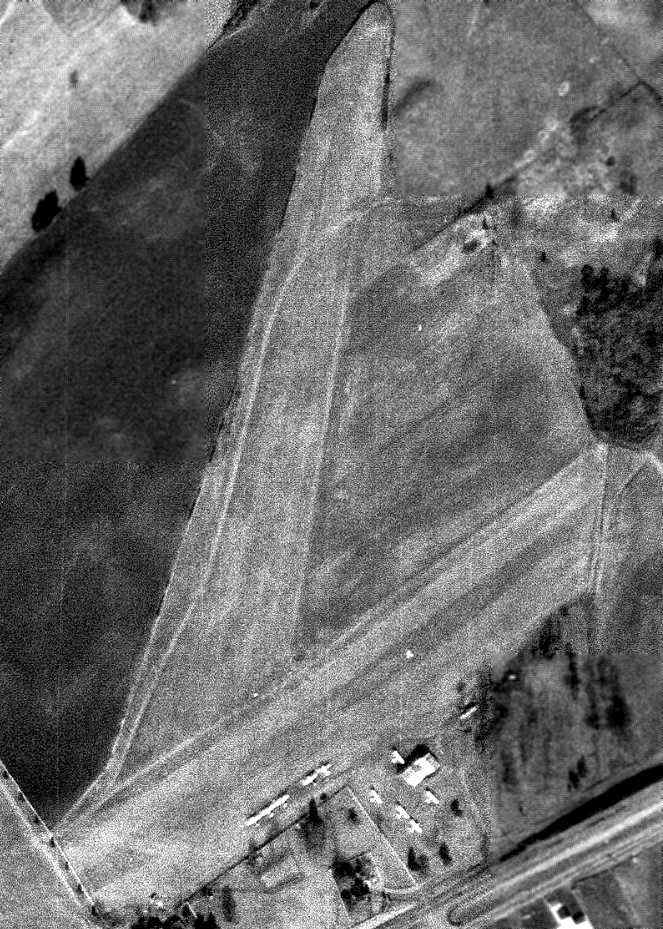
The last photo which has been located showing the original Culpeper Airport still in operation
was a 4/17/72 USGS aerial view (courtesy of Dallam Oliver-Lee).
It showed a row of 8 light aircraft at the field.
The status of the original Culpeper Airport had changed to a private airfield
by the time of the 1975 Washington Sectional Chart (courtesy of Ed Drury).
The last aeronautical chart depiction which has been located of the original Culpeper Airport
was on the August 1976 Cincinatti Sectional Chart (courtesy of Mitchell Hymowitz).
After slowly running out of customers, the original Culpeper field closed in 1977.
The 2 runways of the old Culpeper Airport were still depicted on the 1984 USGS topo map,
but it was erroneously labeled "Martin Field".
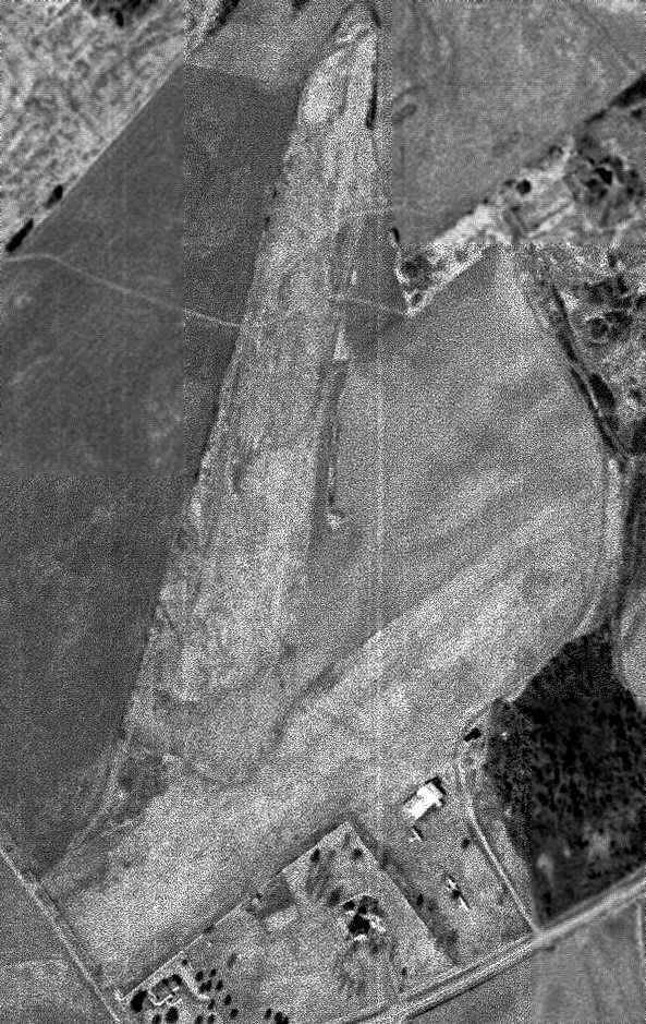
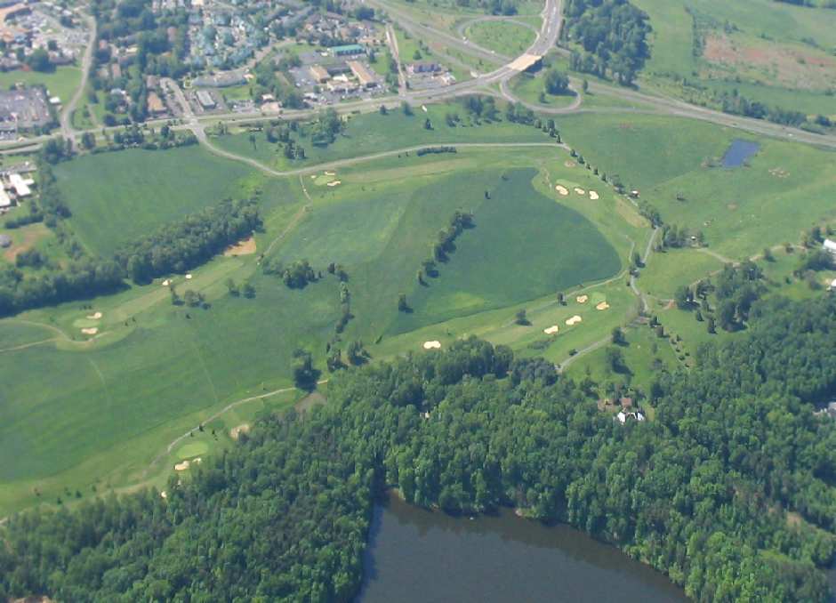
A 4/3/94 USGS aerial photo (courtesy of Dallam Oliver-Lee) showed that the property of the former airport had been redeveloped as a golf course.
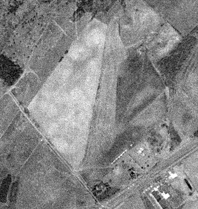
A 2003 aerial view by Paul Freeman looking southeast at the site of the original Culpeper Airport.
The alignment of the former Runway 1/19 was still recognizable
as the row of trees going diagonally from the center of the photo toward the upper-right.
A 6/20/11 aerial view (courtesy of Dallam Oliver-Lee) showed a row of trees along the west side of the property which traced the outline of a runway
as the last remaining trace of the original Culpeper Airport.
The site of the original Culpeper Airport is located north of the intersection of Route 29 & Madison Road.
____________________________________________________
Since this site was first put on the web in 1999, its popularity has grown tremendously.
That has caused it to often exceed bandwidth limitations
set by the company which I pay to host it on the web.
If the total quantity of material on this site is to continue to grow,
it will require ever-increasing funding to pay its expenses.
Therefore, I request financial contributions from site visitors,
to help defray the increasing costs of the site
and ensure that it continues to be available & to grow.
What would you pay for a good aviation magazine, or a good aviation book?
Please consider a donation of an equivalent amount, at the least.
This site is not supported by commercial advertising –
it is purely supported by donations.
If you enjoy the site, and would like to make a financial contribution,
you
may use a credit card via
![]() ,
using one of 2 methods:
,
using one of 2 methods:
To make a one-time donation of an amount of your choice:
Or you can sign up for a $10 monthly subscription to help support the site on an ongoing basis:
Or if you prefer to contact me directly concerning a contribution (for a mailing address to send a check),
please contact me at: paulandterryfreeman@gmail.com
If you enjoy this web site, please support it with a financial contribution.
please contact me at: paulandterryfreeman@gmail.com
If you enjoy this web site, please support it with a financial contribution.
____________________________________________________
This site covers airfields in all 50 states.