Abandoned & Little-Known Airfields:
New Mexico: Roswell area
© 2002, © 2016 by Paul Freeman. Revised 7/6/16.
This site covers airfields in all 50 states: Click here for the site's main menu.
____________________________________________________
Please consider a financial contribution to support the continued growth & operation of this site.
Roswell Aux AAF #1 (revised 8/22/14) - Roswell Aux AAF #2 (revised 8/22/14)
Roswell Aux AAF #3 (revised 8/22/14) - Roswell Aux AAF #4 (revised 8/22/14)
Roswell Aux AAF #8 / Artesia Field (revised 6/14/14) - Roswell Aux AAF #9 / Roswell Municipal Airport (revised 7/6/16)
___________________________________________________________
Roswell Auxiliary Army Airfield #1, Southwest of Roswell, NM
33.24, -104.63 (Northeast of El Paso, TX)
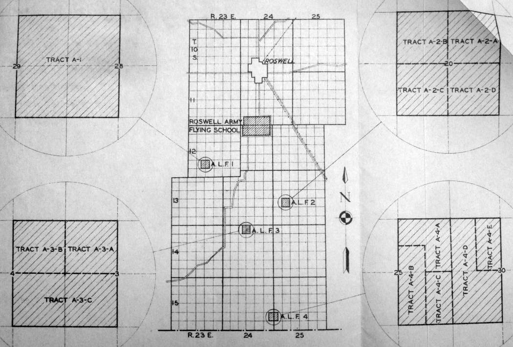
A 12/12/42 AAF map of Roswell AAF & its satellite airfields (found by Ron Plante at NARA Denver).
This field was built during WW2 as one of 9 satellite airfields for Roswell AAF (6 miles northeast),
which conducted training in the B-29 bomber.
The date of construction of the field has not been determined.
The earliest depiction of Roswell Aux #1 which has been located
was a 12/12/42 AAF map of Roswell AAF & its satellite airfields (found by Ron Plante at NARA Denver).
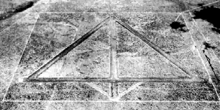
The earliest photo which has been located of Roswell AAF Aux #1
was a 10/5/43 aerial view looking north from the 1945 AAF Airfield Directory (courtesy of Scott Murdock).
It depicted “Roswell AAF Auxiliary #1” as having 4 runways.
The earliest aeronautical chart depiction which has been located of Roswell Aux #1
was on the February 1944 Roswell Sectional Chart (courtesy of Chris Kennedy).
It depicted Roswell Auxiliary #1 in relation to its parent airfield, Roswell AAF.
A 1944 AAF map of Roswell AAF & its satellite airfields (courtesy of John Voss)
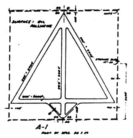
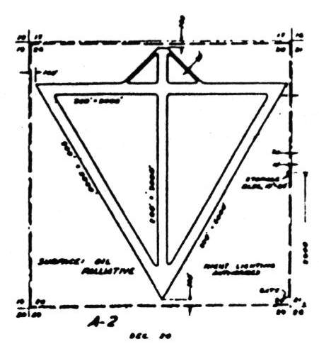
depicted Roswell Auxiliary #1 as having 4 oiled 5,200' runways.
The 1945 AAF Airfield Directory (courtesy of Scott Murdock) described “Roswell AAF Auxiliary #1”
as a 640 acre square property within which were 4 oiled 5,500' runways.
The field was said to not have any hangars.
to be owned by the U.S. Government, and operated by the Army Air Forces.
The date of closure of Roswell Aux #1 has not been determined.
It may have been closed at some point in 1945,
as it was not depicted on the 1945 Roswell Sectional Chart (courtesy of Chris Kennedy),
even though several other Roswell auxiliary fields were still depicted.
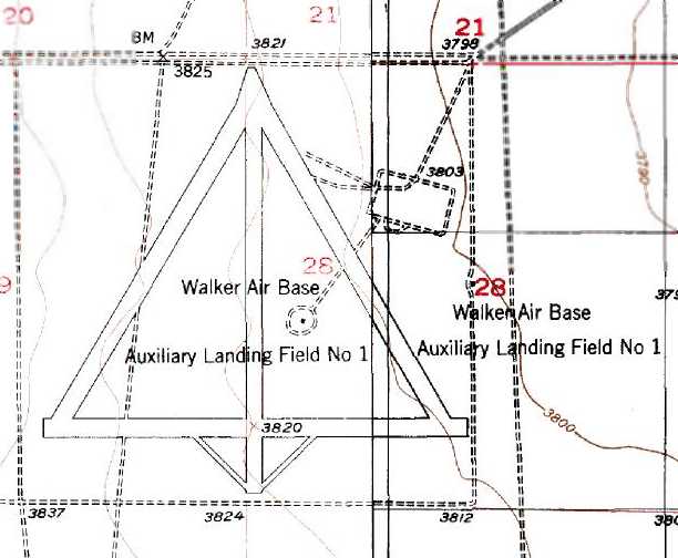
The 1949 USGS topo map depicted the 4 runways as “Walker Air Base Auxiliary Landing Field #1”.
It does not appear as if the airfield was ever reused for civil flying.
It was not depicted at all (even as an abandoned airfield)
on the 1966 Roswell Sectional Chart (courtesy of John Voss).
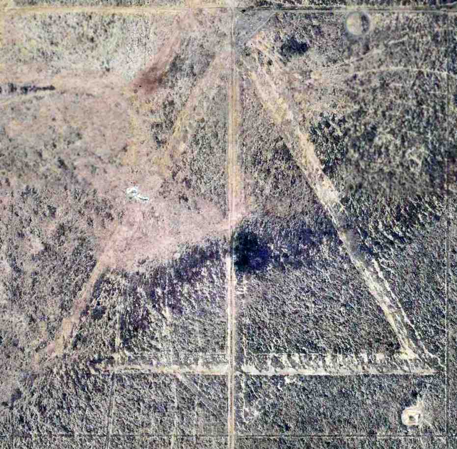
Although somewhat deteriorated, the airfield was still quite apparent in a 9/15/12 aerial photo.
The airfield is not depicted at all (even as an abandoned airfield) on 2002 aeronautical charts.
______________________________________________________
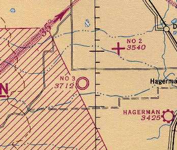
Roswell Auxiliary Army Airfield #2, Dexter, NM
33.18 North / 104.47 West (Northeast of El Paso, TX)
A 12/12/42 AAF map of Roswell AAF & its satellite airfields (found by Ron Plante at NARA Denver).
Photo of the airfield while in use has not been located.
This field was built during WW2 as one of 9 satellite airfields for Roswell AAF (10 miles north),
which conducted training in the B-29 bomber.
The date of construction of Roswell Aux #2 has not been determined.
The earliest depiction which has been located of Roswell Aux #2
was a 12/12/42 AAF map of Roswell AAF & its satellite airfields (found by Ron Plante at NARA Denver).
The airfield layout of Roswell Auxiliary #2,
from a 1944 AAF map of Roswell AAF & its satellite airfields (courtesy of John Voss).
It depicted Roswell Aux #2 as having 4 oiled 5,200' runways.
The only aeronautical chart depiction which has been located of Roswell Aux #2
was on the 1945 Roswell Sectional Chart (courtesy of Chris Kennedy).
Roswell Aux #2 was evidently closed at some point in 1945,
as it was not listed among the active Roswell Auxiliary airfields in the 1945 AAF Airfield Directory (courtesy of Scott Murdock).
It does not appear as if the Roswell Aux #2 airfield was ever reused for civil flying.
It was not depicted at all (even as an abandoned airfield)
on the 1950 USGS topo map nor on the 1966 Roswell Sectional Chart (courtesy of John Voss).
Although somewhat deteriorated, the airfield was still quite apparent in the 1997 USGS aerial photo.
The airfield is not depicted at all (even as an abandoned airfield) on 2002 aeronautical charts.
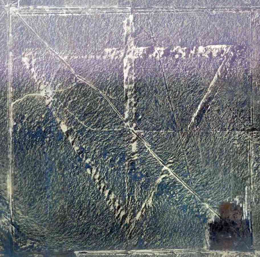
The remains of the 4 runways were still recognizable in a 3/27/10 aerial photo.
Roswell Auxiliary #2 is located southwest of the intersection of Route 285 & Shawnee Road.
______________________________________________________
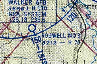
Roswell Auxiliary Army Airfield #3, Dexter, NM
33.13 North / 104.55 West (Northeast of El Paso, TX)
A 12/12/42 AAF map of Roswell AAF & its satellite airfields (found by Ron Plante at NARA Denver).
This field was built during WW2 as one of 9 satellite airfields for Roswell AAF (located 11 miles north),
which conducted training in the B-29 bomber.
The date of construction of the field has not been determined.
The earliest depiction of Roswell Aux #3 which has been located
was a 12/12/42 AAF map of Roswell AAF & its satellite airfields (found by Ron Plante at NARA Denver).
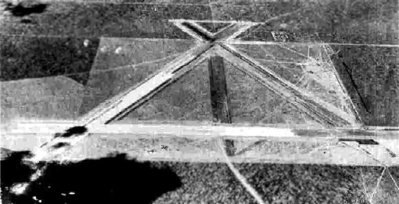
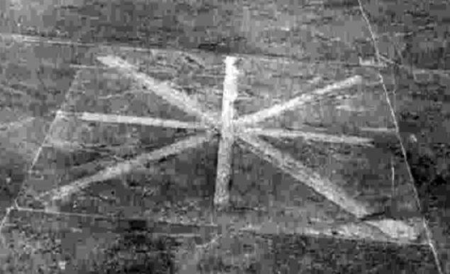
The earliest photo which has been located of Roswell Aux #3
was a 10/5/43 aerial view looking north from the 1945 AAF Airfield Directory (courtesy of Scott Murdock).
It depicted “Roswell AAF Auxiliary #3” as having 4 runways.
The earliest aeronautical chart depiction which has been located of Roswell Aux #3
was on the 1945 Roswell Sectional Chart (courtesy of Chris Kennedy).
Roswell Aux #3 may have had a more important role than the rest of the Roswell auxiliary fields,
as it was depicted with the normal military airfield symbol,
as opposed to the "auxiliary" field symbol used for all of the other Roswell auxiliary fields.
The 1945 AAF Airfield Directory (courtesy of Scott Murdock) described “Roswell AAF Auxiliary #3”
as a 760 acre square property within which were 3 bituminous 7,000' runways.
The field was said to not have any hangars.
to be owned by the U.S. Government, and operated by the Army Air Forces.
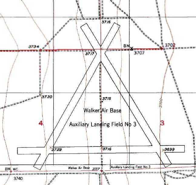
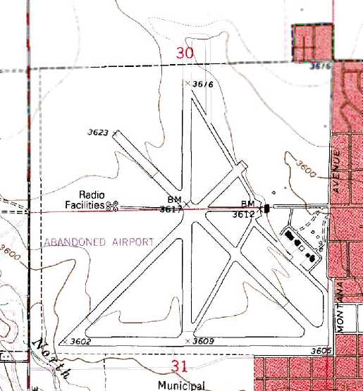
The 1949 USGS topo map depicted 3 runways,
labeled “Walker Air Base Auxiliary Landing Field #3”.
"Roswell #3" was still depicted on the March 1954 Roswell Sectional Chart(courtesy of Chris Kennedy).
It was depicted as having a 7,000' hard surface runway.
"Roswell #3" was still depicted as an active airfield
on the February 1958 Estacado Plain World Aeronautical Chart(courtesy of Chris Kennedy).
It was depicted as having a 7,000' hard surface runway.
The Roswell Aux #3 airfield was apparently abandoned at some point between 1958-60,
as it was no longer depicted at all on the August 1960 Estacado Plain World Aeronautical Chart (according to Chris Kennedy).
The evident reason for the closure of the Roswell Aux #3 airfield
was so that the property could be reused as the location of one of 2 Nike-Hercules surface-to-air missile batteries
which were constructed to defend nearby Walker AFB, a SAC bomber base.
The Roswell Aux #3 property became home to both components (control site & launch site) of Walker Nike Battery WA-50.
However, in a bizarre example of military planning, the Walker Nike sites (WA-10 & WA-50)
were activated in April 1960 & then deactivated a mere 2 months later,
without ever having been declared operational.
Tom Tracey reported, "Back in 1973-74, that airfield & its buildings were home to Villa Solano State School,
which was a state institution for mentally handicapped boys.
I was the vocational director at Villa Solano.
I kept a Taylorcraft at the Roswell Industrial Air Center & regularly commuted from the air center
(I lived in the old base housing) to work at Villa Solano in the T-Craft.
In 1973, a friend of mine & I built a Starduster Two.
We really didn't want to crash & burn on our first flight,
right in front of the FAA guys in the control tower at the Air Center.
We took the Starduster, in pieces, to the old runway at Villa Solano, put her together,
and flew her out of there for about a month.
The same goes for a KR-1 a year later."
Tom continued, "On weekends, a bunch of us pilots would use that runway
(T-Crafts, Pacers, Super Cruisers, Ercoupes, and even one Swift).
Good places for camping right next to the runway.
Lots of underground bunkers still intact.
We used to keep 55 gallon barrels of gas in one of them."
The 1975 USGS topo map only depicted a single runway (northeast/southwest),
labeled “Walker Air Base Auxiliary Landing Field #3 (Abandoned)”.
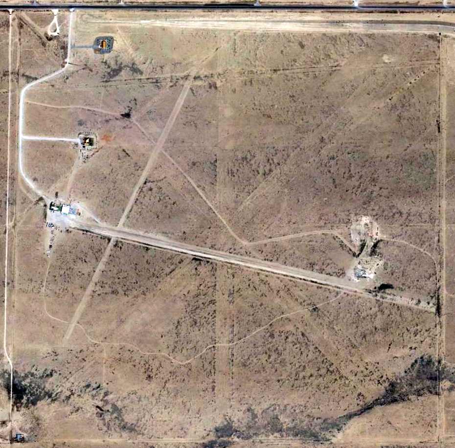
At some point the former Nike control site was reused as the location of the Roswell Correctional Center,
and the launch site was abandoned but partially intact.
Don Tedrow recalled, "I arrived at the Roswell Industrial Air Center in 1980, my first ATC posting.
I know that Auxiliary Field #3 was already in use as a correctional facility at that time.
I recall landing there once or twice, probably in 1981 or so.
I recall some pilots occasionally using it up through about 1983 or so,
when the Prison officials put word out they didn't want any aviation activity there any more."
Tom Tracey reported, "I've used that old runway at that place ever since.
I recently flew down that way from Grants, NM in my Sonerai II and landed there.
Now days, all the prison officials get all bent out of shape about it.
God knows how many guys you could fly out of there in a Sonerai.
"Why in the $%& do people think old airports make good minimum security prisons?
Why not just let a bunch of pilots make them back into airports?
I've been in the control center for the place. Nothing left in it to speak of."
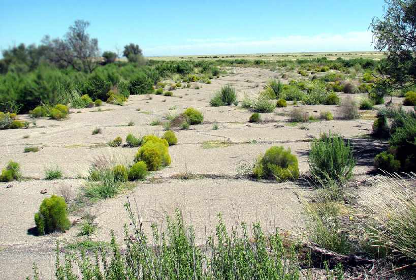
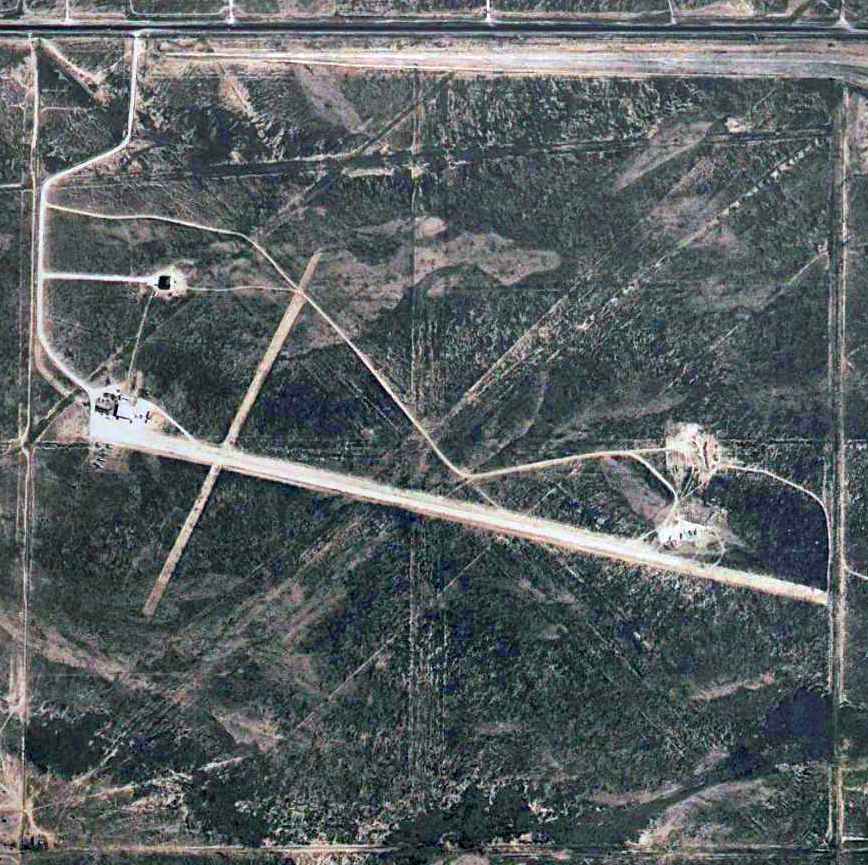
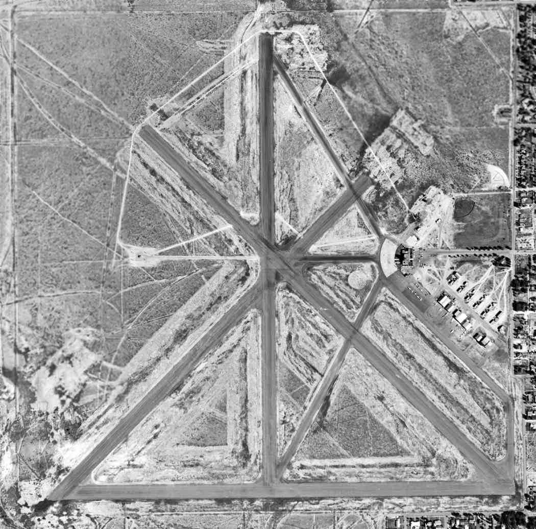
A 2006 photo by Scott Murdock of the remains of pavement at the site of Roswell Aux AAF #3.
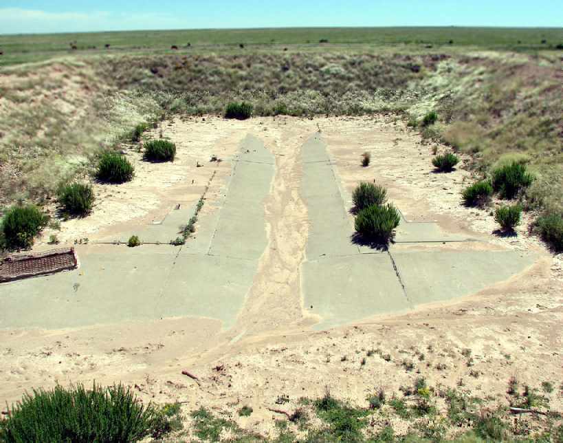
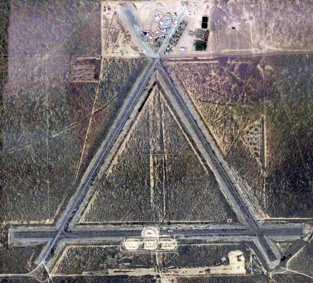
A 3/27/10 aerial photo showed the airfield to remain in good condition.
The former Nike missile launch site appeared to be in the center of the east/west runway,
with the remains of the 3 launchers visible as 3 cleared rectangular areas.
The precise location of the Nike control site is unknown,
but it may have been at the northern runway intersection in the area now occupied by prison buildings.
See also: http://www.airforcebase.net/usaf/usafnike.html
______________________________________________________
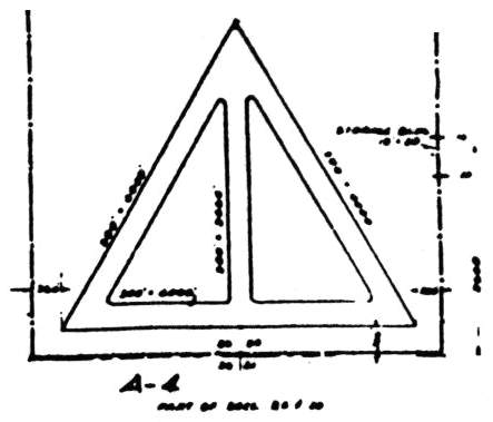
Roswell Auxiliary Army Airfield #4, Lake Arthur, NM
32.98 North / 104.49 West (Northeast of El Paso, TX)
A 12/12/42 AAF map of Roswell AAF & its satellite airfields (found by Ron Plante at NARA Denver).
Photo of the airfield while in use has not been located.
This field was built during WW2 as one of a string of satellite airfields for Roswell AAF (21 miles north),
which conducted training in the B-29 bomber.
The date of construction of the field has not been determined.
The earliest depiction of the field which has been located
was a 12/12/42 AAF map of Roswell AAF & its satellite airfields (found by Ron Plante at NARA Denver).
The airfield layout of Roswell Auxiliary #4,
from a 1944 AAF map of Roswell AAF & its satellite airfields (courtesy of John Voss).
This airfield was somewhat smaller than the other Roswell auxiliary fields -
it was depicted as having 4 oiled 4,500' runways.
Roswell Aux #4 was evidently closed at some point between 1944-45,
as it was not depicted on the 1945 Roswell Sectional Chart (courtesy of Chris Kennedy),
nor listed among the active Roswell Auxiliary airfields in the 1945 AAF Airfield Directory (courtesy of Scott Murdock).
The 1949 USGS topo map depicted 3 paved runways, labeled “Walker Air Base Auxiliary Landing Field”.
It does not appear as if Roswell Aux #4 was ever reused for civil flying,
as it was not depicted at all (even as an abandoned airfield)
on the 1966 Roswell Sectional Chart (courtesy of John Voss) or subsequent aeronautical charts.
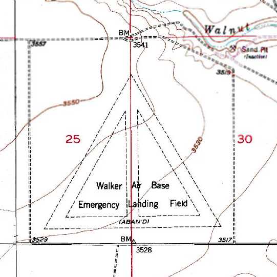
The 1975 USGS topo map depicted 4 runways,
labeled “Walker Air Base Emergency Landing Field”.
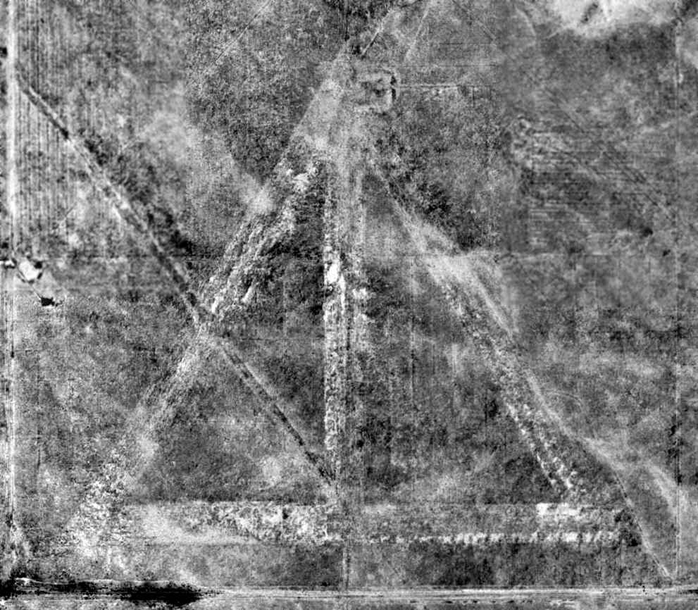
Although somewhat deteriorated, the airfield was still quite apparent in a 10/8/97 USGS aerial photo.
The airfield is not depicted at all (even as an abandoned airfield) on 2002 aeronautical charts.
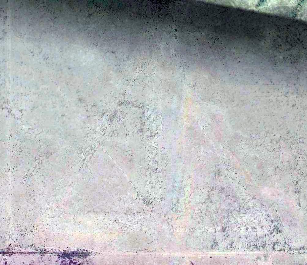
The outline of the Roswell Aux #4 airfield was barely recognizable in a 4/16/13 aerial photo -
it had deteriorated much more so than the other Roswell-area auxiliary airfields.
Roswell Auxiliary #4 is located northwest of the intersection of Route 2 & East Jackson Road.
______________________________________________________
(Original) Artesia Municipal Airport / Roswell Auxiliary Army Airfield #8 / Artesia Field, Artesia, NM
32.84 North / 104.51 West (Northeast of El Paso, TX)
A 9/2/41 aerial view looking north at “Artesia Municipal Airport (Old)” from the 1945 AAF Airfield Directory (courtesy of Scott Murdock).
The date of construction of this airport has not been determined.
The earliest photo which has been located of the original Artesia Municipal Airport (west-southwest of the town)
was a 9/2/41 aerial view looking north from the 1945 AAF Airfield Directory (courtesy of Scott Murdock).
It depicted “Artesia Municipal Airport (Old)” as having 4 unpaved runways.
The 1945 AAF Airfield Directory (courtesy of Scott Murdock) described “Artesia Municipal Airport (Old)”
as a 640 acre square-shaped property having 4 sod & clay runways,
the longest being a 6,300' northeast/southwest strip.
The field was said to have a single 40' x 28' metal hangar, and to be owned by the U.S. Government.
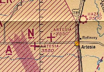
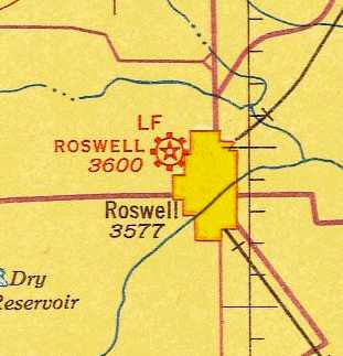
The 1945 Roswell Sectional Chart (courtesy of Chris Kennedy) depicted 2 auxiliary airfields labeled "Artesia" -
the original Artesia Municipal Airport (south of the road) & what later became the present-day Artesia Airport (north of the road).
This field may have been used during WW2 as Roswell Auxiliary Airfield #8, one of 9 satellite airfields for Roswell AAF (located 7 miles south),
which conducted training in the B-29 bomber.
The Artesia Aux #8 airfield was evidently abandoned at some point between 1945-46,
as the June 1946 Department of Commerce Airman's Guide (according to Chris Kennedy)
described the “Artesia Municipal Airport, old” as abandoned as of 5/15/46.
The 1957 USGS topo map depicted 4 unpaved runways, labeled "Emergency Landing Field (Abandoned)".
It was no longer depicted at all (even as an abandoned airfield)
on the 1966 Roswell Sectional Chart (courtesy of John Voss).
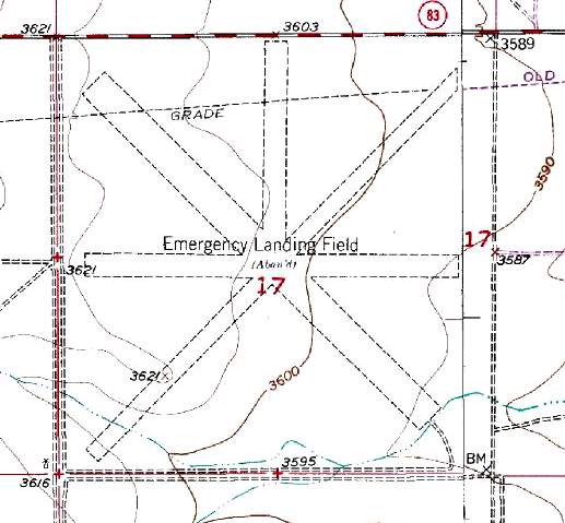
It was labeled "Emergency Landing Field (Abandoned)" on the 1991 USGS topo map.
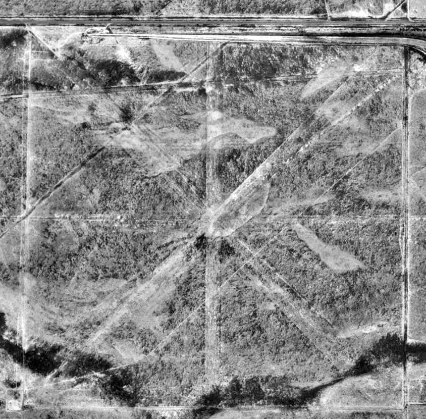
The remains of the runways were badly deteriorated but still recognizable in the 1997 USGS aerial photo.
The airfield appeared to have consisted of 4 runways (the longest was 6,300'),
which may or may not have been paved.
It was not depicted at all (even as an abandoned airfield) on 2002 aeronautical charts.
A 6/30/05 aerial view (courtesy of Chris Kennedy) shows that a new airfield
was built over the site of the old Artesia airfield at some point between 1997-2005, with 2 newly cleared dirt runways.
Strange though that neither runway was constructed over the alignment of one of the 4 former runways.
Chris noted, “There's nothing in the Airport/Facility Directory, but it sure likes like there's a hangar there & an airplane parked next to it.”
A 4/16/13 aerial view showed a single small twin-engine aircraft (with a bent left wingtip) parked on the southwest side of the east/west runway.
The site of Artesia Auxiliary Army Airfield #8 is located only 2 miles southwest of the present-day Artesia Municipal Airport.
______________________________________________________
Roswell Municipal Airport / Roswell Auxiliary Army Airfield #9, Roswell, NM
33.41, -104.55 (Northeast of El Paso, TX)
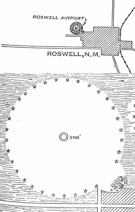
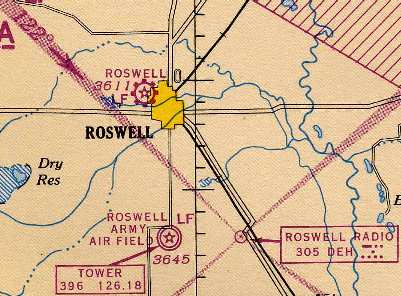
The location & layout of the Roswell Airport,
as depicted on the 5/24/30 Department of Commerce Airway Bulletin (courtesy of Jonathan Westerling).
The Roswell Municipal Airport was originally located adjacent to the northwest side of the town.
The date of construction of the Roswell Municipal Airport has not been determined.
The earliest reference to the field which has been located
was in the November 1929 Standard Oil "Airplane Landing Fields of the Pacific West" (courtesy of Chris Kennedy).
It described Roswell Municipal Airport as being located "1 mile northwest of town",
and said the field consisted of a 3,100' sod "any direction" landing area.
A steel hangar was said to have the field name painted on the roof.
The earliest depiction of the Roswell Airport which has been located
was on the May 24, 1930 Department of Commerce Airway Bulletin (courtesy of Jonathan Westerling).
It described Roswell as a municipal field, owned & operated by the Roswell Airport Company.
The field was described as a 3,100' diameter circular sod landing area, measuring 350 acres.
A hangar, administration building, and beacon tower were depicted in the southeast edge of the field.
The earliest aeronautical chart depiction which has been located of the Roswell Airport
was on the 1935 Roswell Sectional Chart.
It depicted Roswell as a commercial/municipal airport.
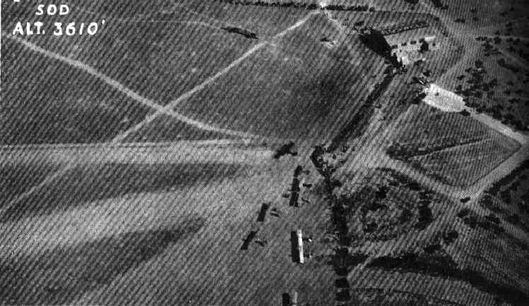
An aerial view of Roswell Municipal, showing several airplanes & a single hangar (with "Roswell" painted on the roof),
from the Airport Directory Company's 1937 Airports Directory (courtesy of Bob Rambo).
The directory described Roswell Municipal as consisting of a 3,100' diameter circular sod field.
Roswell Municipal Airport was taken over by the military during WW2
and used as one of 9 satellite airfields for Roswell AAF (located 7 miles south),
which conducted training in the B-29 bomber.
Roswell's circular landing area was evidently replaced with longer runways at some point between 1937-44,
as the April 1944 US Army/Navy Directory of Airfields (courtesy of Ken Mercer)
described Roswell Airport as having a 5,600' unpaved runway.
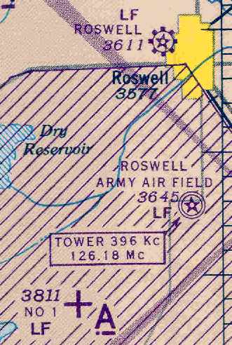
Roswell Airport, as depicted on the 1945 Roswell Sectional Chart (courtesy of Chris Kennedy).
After WW2 the airport resumed its civilian role as the Roswell Municipal Airport.
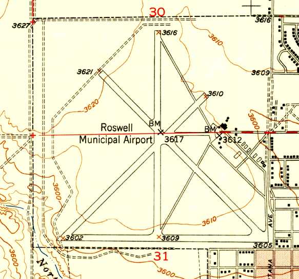
The 1949 USGS topo map depicted “Roswell Municipal Airport” as having 4 paved runways, taxiways, ramps, and several hangars.
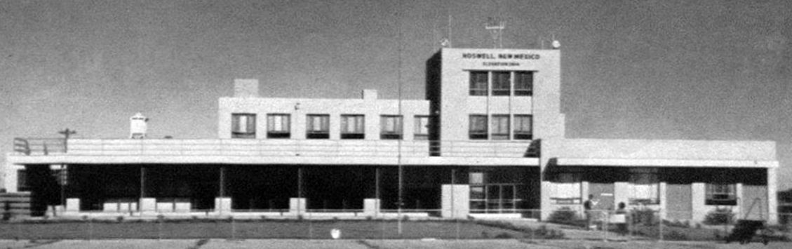
An undated (pre-1960) photo of the Roswell Airport terminal building, before it gained a control tower on top
(from a 9/1/15 City of Roswell press release “Former city airport’s terminal building coming down”, courtesy of Tim Hahn).
The Roswell Airport terminal building gained a control tower on top in 1960,
according to the 9/1/15 City of Roswell press release “Former city airport’s terminal building coming down” (courtesy of Tim Hahn).
A 9/22/61 USGS aerial photo depicted Roswell as having 4 paved runways,
with a number of light aircraft on the ramp near the hangars on the east side.
Roswell Municipal Airport was listed among active airports in the 1962 AOPA Airport Directory,
with 4 paved runways, and the operators listed as Airlane Aviation & Callens Flying Service.
“Roswell Municipal Airport” was depicted on the 1964 USGS topo map in an unchanged fashion compared to the 1949 topo map.

Roswell Municipal Airport was depicted on the 1966 Roswell Sectional Chart (courtesy of John Voss)
as having 4 paved runways, with the longest being 5,800'.
The Roswell Municipal Airport was closed in 1975,
after the much larger Walker AFB (former Roswell AAF) had been closed by the military & made available for civil use.
The 1975 USGS topo map depicted 4 runways, taxiways, ramps, and several hangars, labeled “Abandoned Airport”.
The north end of the north/south runway had been somewhat lengthened at some point between 1964-75.
According to Don Tedrow, "During the early 1980s,
the old Roswell Municipal Airport & Terminal was used by the Roswell Police Department.
Several of the older controllers I worked with had worked the original Muni airport before it closed.
The last aircraft I know of landing there would have been a Mooney during the winter of 1980-81.
The Mooney got disoriented in a snowstorm & landed on the old runways,
dodging some barricades the Police had erected as obstacles for pursuit training.
He flew it out a few days later after the weather cleared."
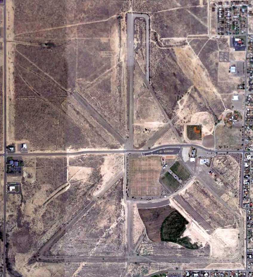
A 2003 photo by Dick Merrill of the remains of Roswell Municipal Airport.
The property of the former airport was still largely intact, and the outlines of the former runways were still recognizable.
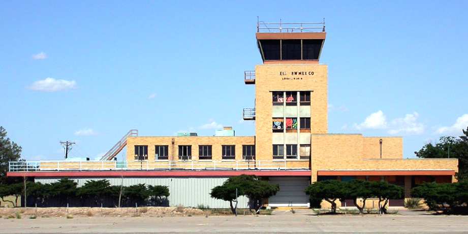
A 2003 photo by Thomas Grimm of the former control tower of the former Roswell Municipal Airport,
now reused as a teen center.
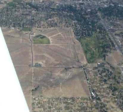
Thomas Grimm visited the site of the former Roswell Municipal Airport in 2003.
"The old terminal is now a Teen Center of some sort.
The city has made part of the old airfield into a park (The green area in the [above 2003 aerial ] photo
and I believe the terminal is at the top of the green area),
and the rest of it awaits development of some sort."
Jane Batson reported in 2005, “The REACH 2000 Board is starting the process
to get the old Roswell Municipal Airport declared a historic property on the state & national registers.”
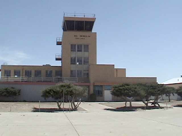
A 2006 photo of the Roswell Municipal control tower by John Wienand.
John Wienand visited the site of the Roswell Municipal Airport in 2006.
He reported, “The field & buildings were in fair repair
until the city or whomever developed it into a high end residential development.
Golf course, recreation facility, soccer fields and the like.
The terminal & the original shed is still standing, painted desert tan.
Parts of the runway/taxiway are still visible from the air but have been converted to gravel for running, etc.
The tower & terminal is unused but secured, and attractively maintained.
From the top of the tower a lot of the concrete taxiways & runways are visible,
or at least their outlines of where they used to be.
The city owns [the site of the former airport].
They really did well with it, aside from moving the airport from the city center,
its an attractive part of town, has lead to other development around it,
and how often in urban planning do you get 2 or 3 thousand acres to develop in the center of town?
Hats off to Roswell for turning that entire situation around.”
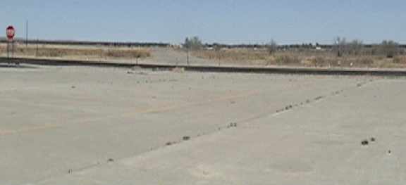
A 2006 photo by John Wienand of the remains of runways at the site of the former Roswell Municipal Airport.
John reported the photo “is looking northeast from the base of the control tower with 2 or 3 taxiways visible, converted to gravel.
The black ribbon visible in the middle of the frame is a new connector road an 18-hole golf course,
residential development, and extensive landscaping have gone into the area.”
A 3/27/10 aerial photo showed the remains of the 4 paved runways at Roswell were still quite apparent.
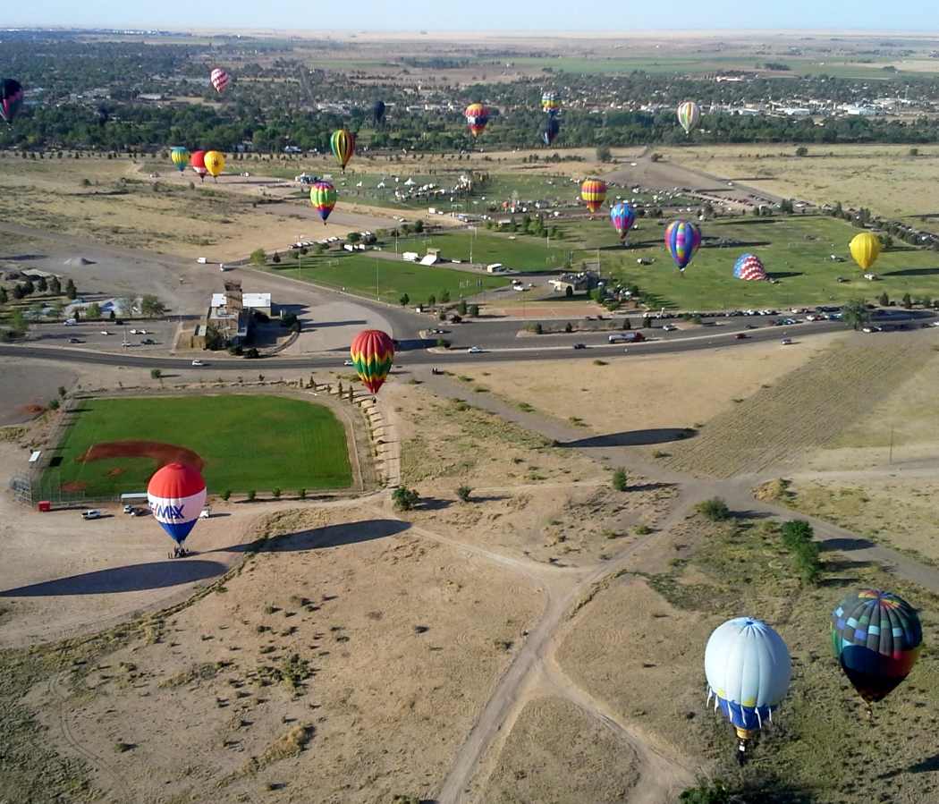
A remarkable May 2014 aerial view by Gil Davis looking south from his balloon at the Roswell Municipal Airport control tower, taken during the Roswell Old-timer's balloon rally.
Gil reported, “I noticed some interesting things from the air - runways!
You can clearly see the runways extending out from the field.”
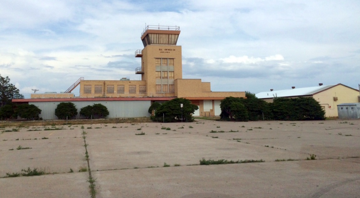
A 7/3/15 photo by Timothy Hahn of the abandoned Roswell Municipal Airport control tower & ramp.
Timothy reported, “Unfortunately, the local news says it is slated for demolition this year. The teen center that was there moved to a new location.
There are 2 parks there & several soccer & baseball fields.”
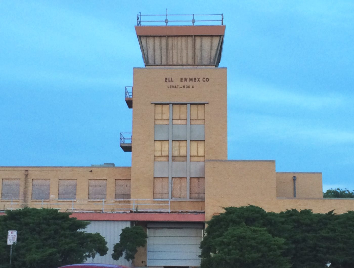
A 7/3/15 photo by Timothy Hahn of the abandoned Roswell Municipal Airport control tower.
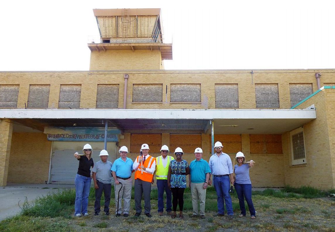
A photo of Roswell city employees gathered to begin the demolition of the Roswell Airport terminal building
(from a 9/1/15 City of Roswell press release “Former city airport’s terminal building coming down”, courtesy of Tim Hahn).
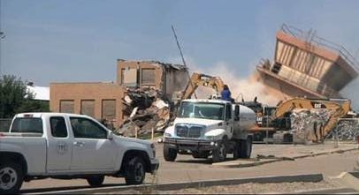
A sad 2015 photo showing the Roswell Municipal Airport control tower being demolished (courtesy of Tim Hahn).
____________________________________________________
Since this site was first put on the web in 1999, its popularity has grown tremendously.
That has caused it to often exceed bandwidth limitations
set by the company which I pay to host it on the web.
If the total quantity of material on this site is to continue to grow,
it will require ever-increasing funding to pay its expenses.
Therefore, I request financial contributions from site visitors,
to help defray the increasing costs of the site
and ensure that it continues to be available & to grow.
What would you pay for a good aviation magazine, or a good aviation book?
Please consider a donation of an equivalent amount, at the least.
This site is not supported by commercial advertising –
it is purely supported by donations.
If you enjoy the site, and would like to make a financial contribution,
you
may use a credit card via
![]() ,
using one of 2 methods:
,
using one of 2 methods:
To make a one-time donation of an amount of your choice:
Or you can sign up for a $10 monthly subscription to help support the site on an ongoing basis:
Or if you prefer to contact me directly concerning a contribution (for a mailing address to send a check),
please contact me at: paulandterryfreeman@gmail.com
If you enjoy this web site, please support it with a financial contribution.
please contact me at: paulandterryfreeman@gmail.com
If you enjoy this web site, please support it with a financial contribution.
____________________________________________________
This site covers airfields in all 50 states.