Abandoned & Little-Known Airfields:
New Hampshire
© 1999, © 2016 by Paul Freeman. Revised 10/11/16.
____________________________________________________
Please consider a financial contribution to support the continued growth & operation of this site.
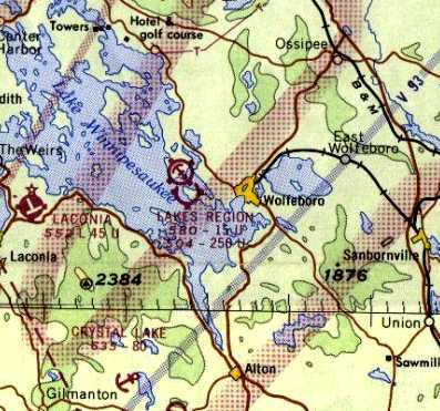
Alstead Airfield / Whitcomb Landing Strip (added 10/11/16) - Cibor Airport / Rye Airfield (revised 5/24/14)
Lakes Region Airport (revised 6/19/16) - Northeastern Gliderport / New England Gliderport (added 10/26/13)
Pike Airfield (revised 5/6/16) - Riverside Airport (revised 7/22/16) - White Mountain Airport (revised 8/23/16)
____________________________________________________
Alstead Airfield / Whitcomb Landing Strip, Walpole, NH
43.128, -72.402 (North of Boston, MA)
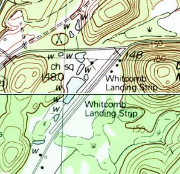
Whitcomb Landing Strip, as depicted on the 1985 USGS topo map.
This small general aviation airport was evidently established at some point between 1972-75,
as it was not yet depicted on the 1972 USGS topo map.
The earliest depiction which has been located of Whitcomb Landing Strip was on the 1985 USGS topo map.
It depicted a single paved northeast/southwest runway.
Rick Boswell reported in 2016, “I am a NH resident and have for 30+ years driven past the airport in Alstead [Whitcomb].
It was previously identified on Sectional Charts as Alstead.
In the earlier years, it was operational but shut down sometime in the last 20 or so years.”
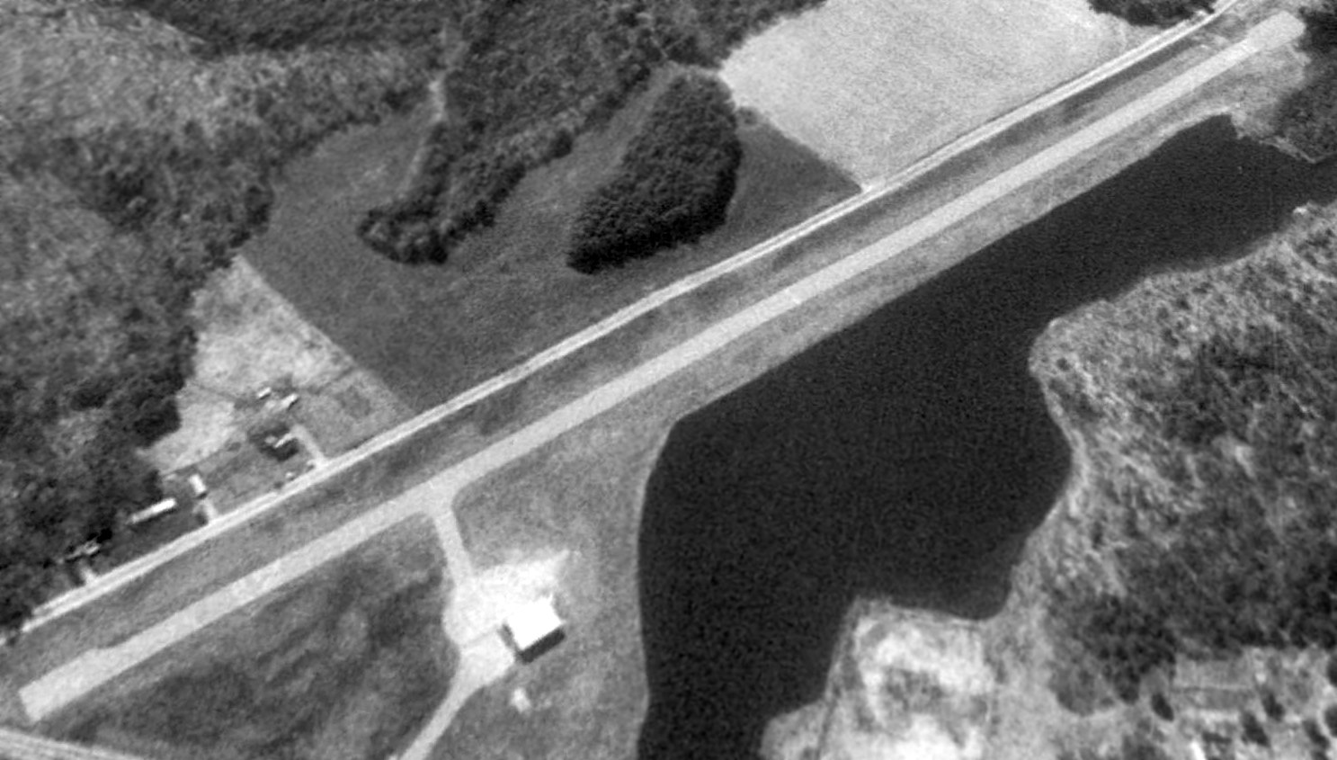
The earliest photo which has been located of Whitcomb Landing Strip was a 1992 USGS aerial view looking southeast.
It depicted Whitcomb as having a single paved runway, with a taxiway leading to a small hangar on the west side.
There were no aircraft visible on the field.
The 1998 USGS topo map depicted Whitcomb Landing Strip
as having a single paved northeast/southwest runway, with one hangar on the west side.
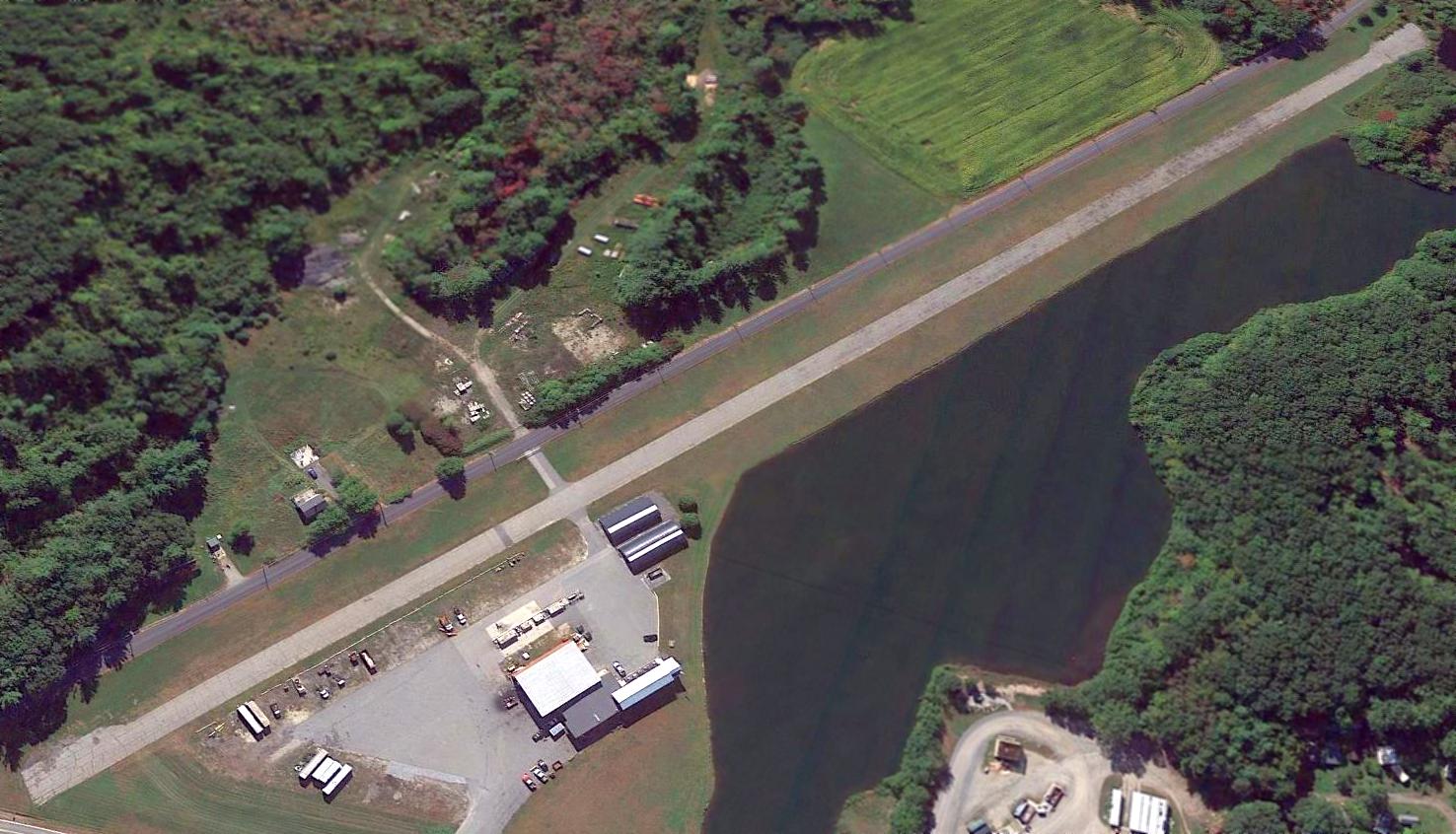
A 2014 aerial view looking southeast showed the Whitcomb Landing Strip remained intact though somewhat deteriorated.
Rick Boswell reported in 2016, “A construction materials company has taken over the site.
An asphalt paving company (Whitcomb Company I think) is now located there.
The paved runway remains visible but is in rough shape.”
Whitcomb Landing Strip is located southwest of the intersection of Whitcomb Road & Old Drewsville Road.
Thanks to Rick Boswell for pointing out this airfield.
____________________________________________________
Riverside Airport, Ashland, NH
43.74, -71.67 (North of Boston, MA)
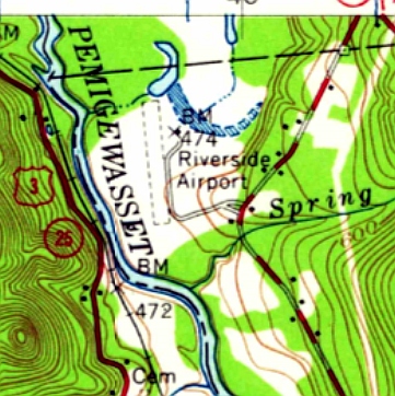
Riverside Airport, as depicted on the 1956 USGS topo map.
This small general aviation airport was evidently established at some point between 1945-56,
as it was not yet depicted on the 1945 Boston Sectional Chart.
The earliest depiction which has been located of Riverside Airport was on the 1956 USGS topo map.
It depicted Riverside as having a single unpaved north/south runway, with a small building on the northeast side.
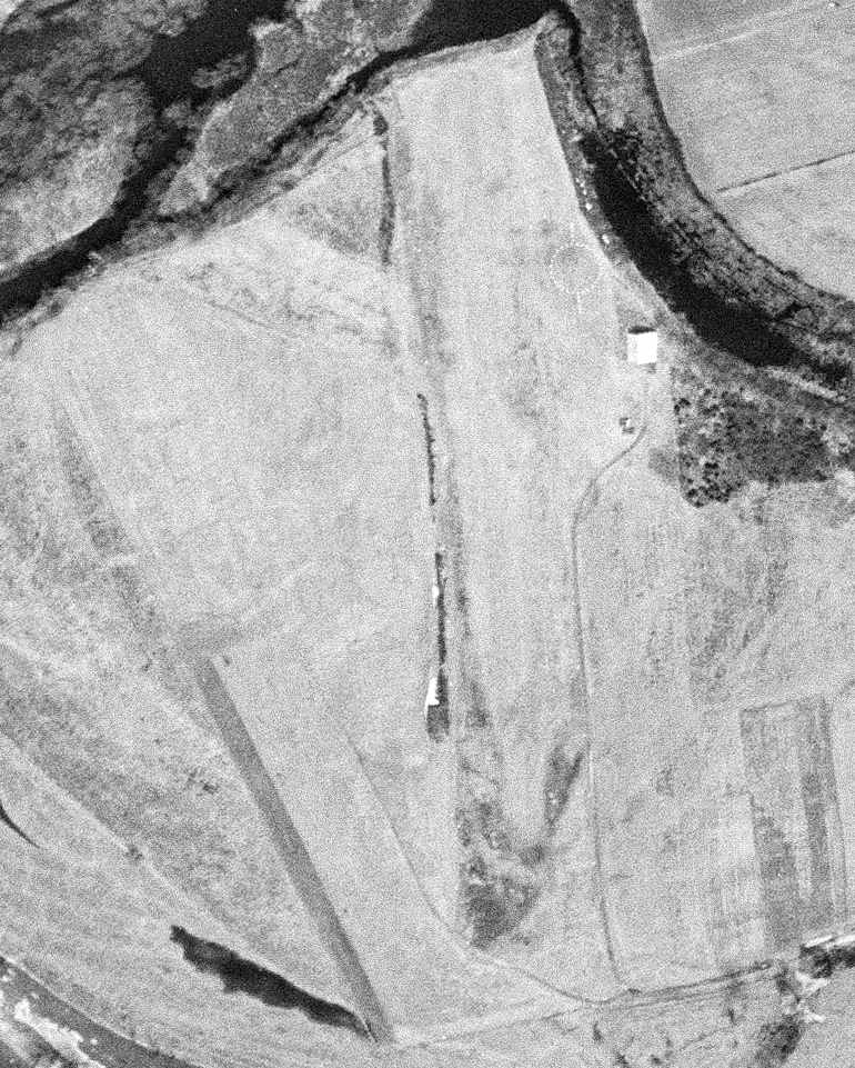
The earliest photo which has been located of Riverside Airport was a 5/2/56 USGS aerial view.
It depicted Riverside as having a single grass north/south runway, with an airport circle marking & a single hangar on the northeast side.
There were no aircraft visible on the field.

The only aeronautical chart depiction which has been located of Riverside Airport was on the 1965 Boston Sectional Chart.
It depicted Riverside as having an 1,800' unpaved runway.
Riverside Airport looked largely unchanged in a 1972 aerial photo,
the only difference being that the airport circle marking was gone.
The last reference which has been located indicating the Riverside Airport as being in use
was a report of a 8/23/93 accident involving a Bellanca 7ECA,
in which its pilot walked into its moving propeller.
The last depiction which has been located of Riverside Airport was on the 1988 USGS topo map.
Dick Bicknell recalled, “Riverside was an annual fly-in fall location for Delta Pilot Reunions, in the late 1980 - early 1990s.”
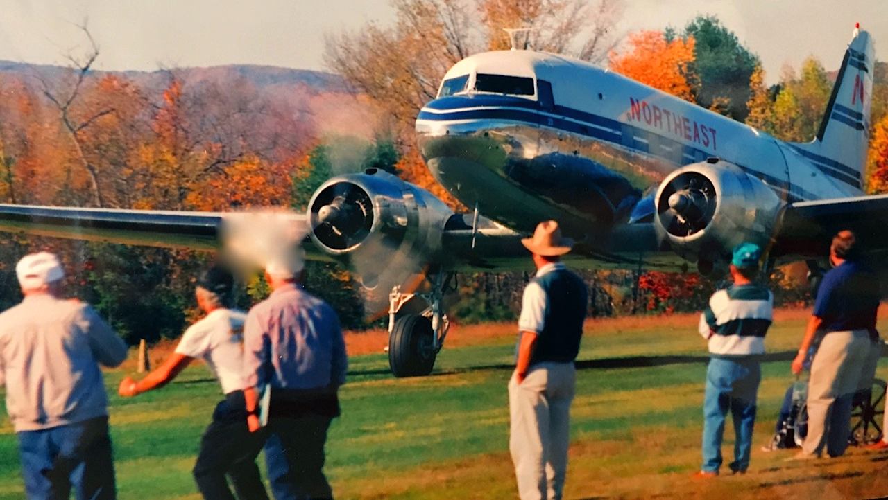
The earliest photo which has been located showing an aircraft at Riverside Airport
was an amazing circa 1990 photo by Dick Bicknell of a “a gorgeous Northeast Airlines restored DC-3 on the initial take off roll”
from the mere 1,900' grass strip during a Delta pilot reunion.
Dick recalled, “The runway was 1,900' plus the golf course which the DC-3 slid on to - the grass being covered with morning dew (no damage done).”
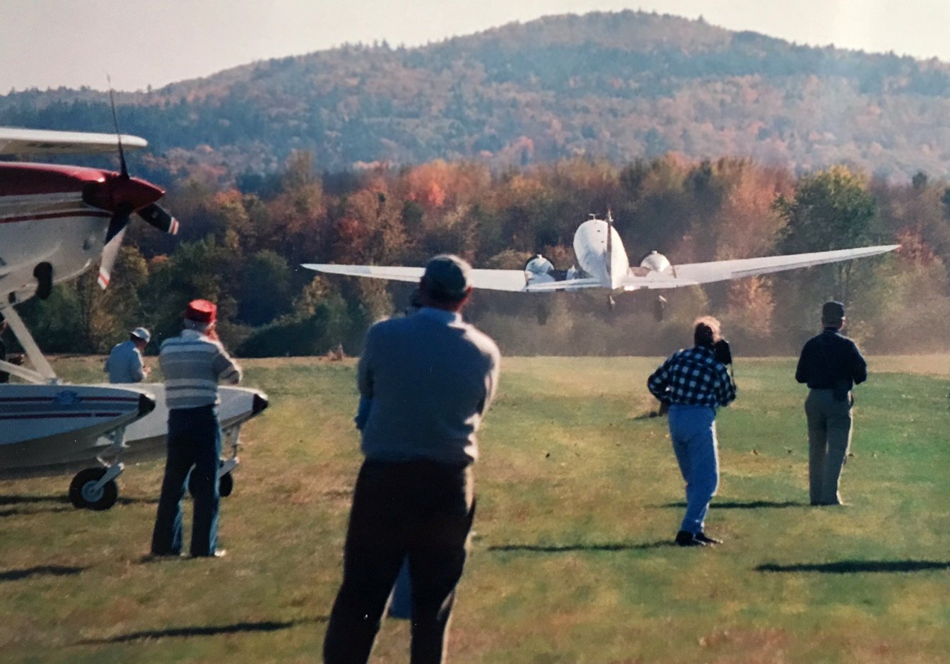
A circa 1990 photo by Dick Bicknell of the Northeast Airlines restored DC-3 departing from Riverside Airport.
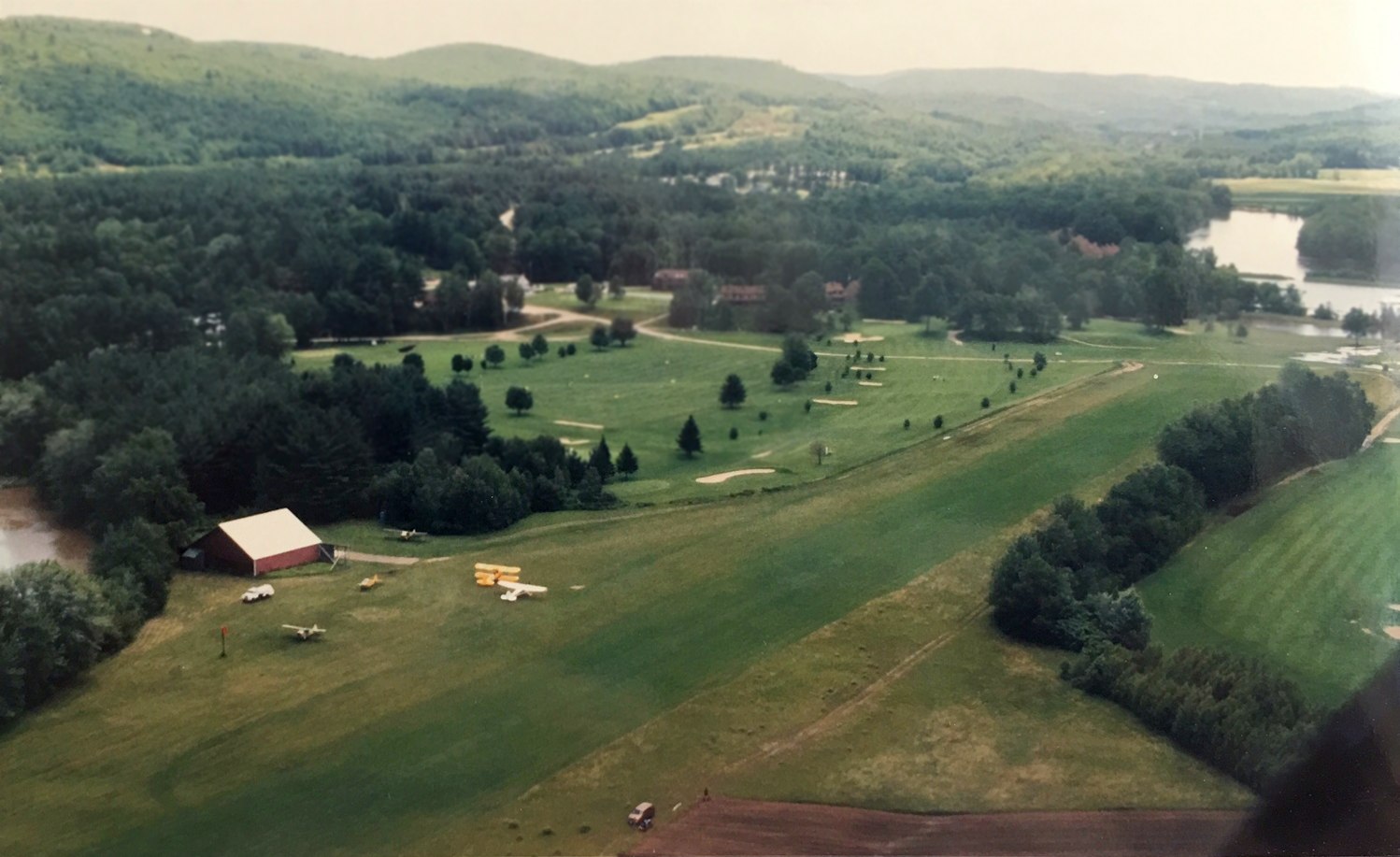
A circa 1990 aerial view by Dick Bicknell looking southeast at Riverside Airport, showing 5 light single-engine aircraft next to the hangar & nice grass runway.
A 1998 USGS aerial photo showed the runway & hangar of Riverside Airport remained intact,
but a golf course had been constructed around the field.
Riverside Airport was evidently closed at some point between 1988-2001,
as the 2001 USGS topo map only labeled the site as “golf course”,
and it did not appear on the 2007 Sectional Chart (according to Dick Whittle).
According to Dick Whittle, the Riverside Airport operations moved to the nearby Plymouth Airport.
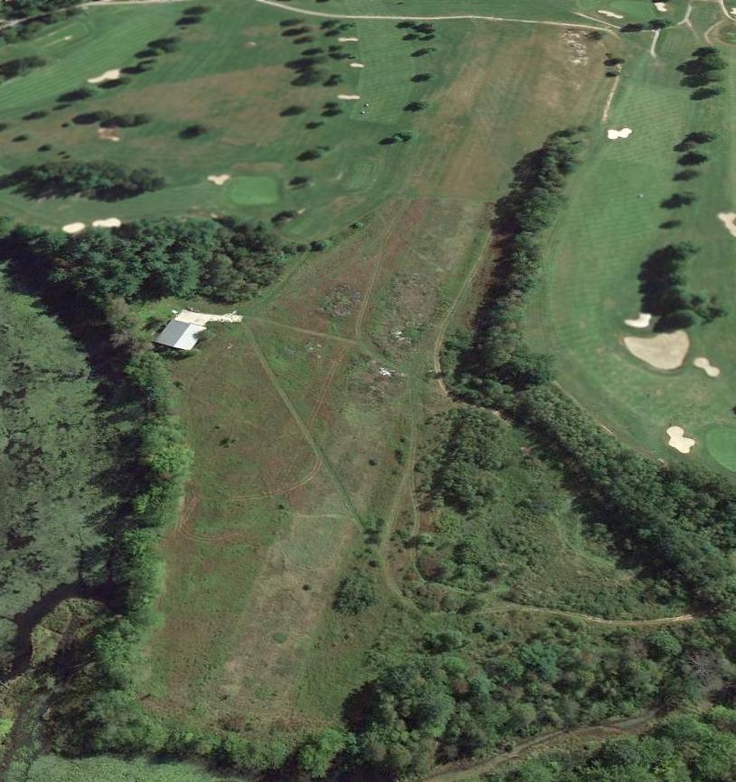
A 9/19/13 aerial view looking southeast showed the runway & hangar of Riverside Airport remained intact, surrounded by a golf course.
As of 2014, street maps labeled the site of Riverside Airport as the White Mountain Country Club.
The site of Riverside Airport is located north of the intersection of North Ashland Road & Airport Road,
appropriately enough.
Thanks to Dick Whittle for pointing out this airfield.
____________________________________________________
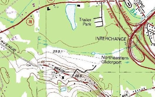
Northeastern Gliderport / New England Gliderport, Salem, NH
42.76 North / 71.24 West (North of Boston, MA)
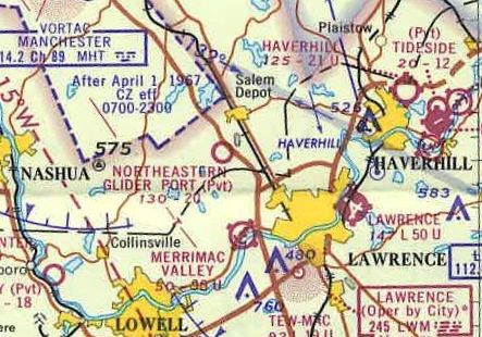
The recently opened Northeastern Glider Port, as depicted on the 1967 Sectional Chart (courtesy of Jonathan Westerling).
According to Jonathan Westerling, “The Northeastern Gliderport was a surprisingly long-lived airfield
catering exclusively to glider operations & open from May through October.
The airfield was started by Dorothy & James Doyle on rented land in Salem NH adjacent to recently completed Interstate 93
in about 1965 (it was not listed in the 1963 Airmans Guide).
The Doyles quickly established their airfield as an exciting new aviation-oriented destination through many articles in the local paper, and even the Boston Globe.”
A 1965 ad in Soaring Magazine touted “Northeastern Gliderport is the only airport in New England set up specifically for sailplane operations.
Powered aircraft visitors are welcome.
Besides being sailplane operators we are also Schweizer sailplane dealers.
See us before you buy - NORTHEASTERN LIGHT AIRCRAFT. INC.”
According to Jonathan Westerling, “For the first several years, the airport hosted annual Glider Meets with contests for pilots & displays for spectators.
The 1967 AOPA Airports USA guide lists Northern Gliderport as having a 2,000' grass Runway 10/28.
The runway was largely unchanged throughout the life of the airfield according to airport directories.
I distinctly remember watching a glider come in over the highway on final when I was a small kid in the back of our Chevy wagon.
I think it was always a private field, but it was well used, and due to the nearby Interstate developed a public awareness even though you couldn’t see the runway.”
According to Jonathan Westerling, “The airfield was featured in an Associated Press news article about the 90th birthday of May Kimball.”
According to the 1966 news item (carried across the country): “If I make it to my 90th birthday, I'm going up in a glider.”
May Kimball, a sprightly, blue-eyed widow, made that pledge last year.
The idea came to her on her 89th birthday as she visited the home of her niece, Mrs. Rudolph Dietrich, in Methuen.
A glider passed over the house & Mrs. Kimball vowed then she'd take a glider ride on her 90th birthday.
She called a Methuen gliderport owner, James Doyle of Andover, and made arrangements for her first flight.
This week she achieved her ambition with an exhilarating glider flight over the Lawrence, MA area.
“Oh, how wonderful, just wonderful. It's so pretty”, Mrs, Kimball exulted when the 20 minutes of soaring was over.
The earliest depiction which has been located of the Northeastern Glider Port was on the 1967 Sectional Chart (courtesy of Jonathan Westerling).
It depicted the Glider Port as a private airfield with a 2,000' unpaved runway.
According to Jonathan Westerling, “According to aerial photography, between 1966-68, a modest terminal building was constructed at the airfield.
At some point thereafter ownership of the Gliderport was transferred to Joe & Ginny Dion.”
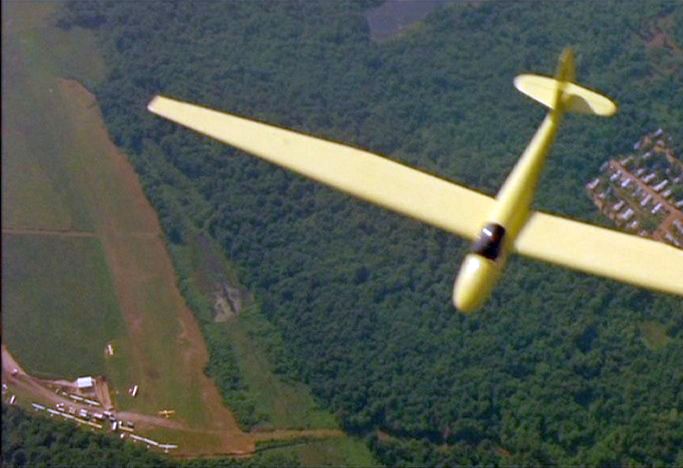
The earliest photo which has been located of the Northeastern Gliderport was an aerial view looking west at a glider (type unidentified) overflying the Gliderport
from the filming of the 1968 movie “The Thomas Crown Affair” (courtesy of Jonathan Westerling).
It depicted over a dozen gliders & single-engine aircraft parked around a small building on the southeast side of an east/west grass runway.
According to Jonathan Westerling, “Portions of the movie The Thomas Crown Affair (the 1968 version) with Steve McQueen & Faye Dunaway were filmed at the Northeast Gliderport.”
According to movie-locations.com, “The airborne scenes were filmed in New Hampshire, at the former Salem Glider Airport.
Although Steve McQueen was filmed in the cockpit on the ground, a local pilot actually flew the plane.”
An online note from Eliza Proctor stated: “Regarding the gliding sequence in The Thomas Crown Affair (1968) with Steve McQueen as pilot... filmed in New England.
Close-ups of McQueen were filmed on the ground & a local glider pilot flew for all other footage [it was a Schweizer registration N9860E].
I don't know the pilot's identity... he was a friend of my father (who was asked to be McQueen's double for the film, but declined).”
In reply to this, Jack O'Leary stated, “The pilot's name was [Leonard] McMasters.
Steve McQueen was in the glider mounted on a tripod for filming cockpit scenes all done at the former Gliderport in Salem off of Brady Avenue.”
The 1987 USGS topo map (courtesy of Jonathan Westerling) depicted the Northeastern Gliderport as having a single unpaved northwest/southeast runway,
with one small building on the southeast side.
The Salem Gliderport was no longer listed in the 1989 AOPA Airports USA (according to Jonathan Westerling).
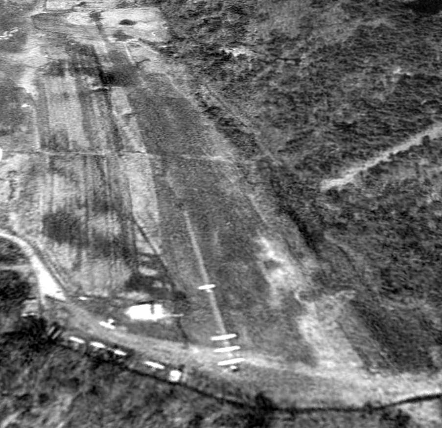
A 4/28/92 USGS aerial view looking northwest depicted 9 gliders & aircraft at the Northeastern Gliderport,
including what looked like 3 gliders lined up to be towed in turn by an aircraft ahead of them.
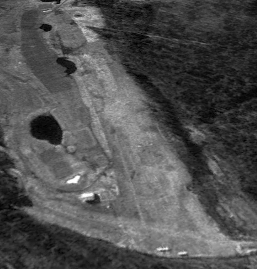
The last photo which has been located which appears to still show aircraft at the Northeast Gliderport was a 3/28/95 USGS aerial view looking northwest.
What appeared to be 2 single-engine aircraft were visible in the foreground at the east end of the runway.
The airport building appeared to remain standing, but construction of a golf course had started adjacent to the south side of the runway,
which would eventually take over the airport property within a few years.
According to Jonathan Westerling, “Joe & Ginny Dion ran the Gliderport until it lost its lease sometime in the 1990s.”
At some point between 1987-96 the field had evidently been renamed New England Gliderport,
as that is how it was depicted on the 1996 Sectional Chart (courtesy of Jonathan Westerling).
The New England Gliderport evidently did not last for very long,
as a 4/10/98 USGS aerial photo showed a golf driving range having been built over the runway.
A 6/10/10 aerial view looking northwest showed the runway outline of Northeast Gliderport remained recognizable,
although the property is used as a golf driving range.
The former airport building remains in use, presumably to support the driving range.
As of 2013 street maps label the site of Northeast Gliderport as Campbell's Scottish Highland Range golf course.
The site of Northeast Gliderport is located northwest of the intersection of Brady Avenue & Courtland Drive.
____________________________________________________
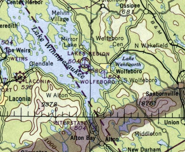
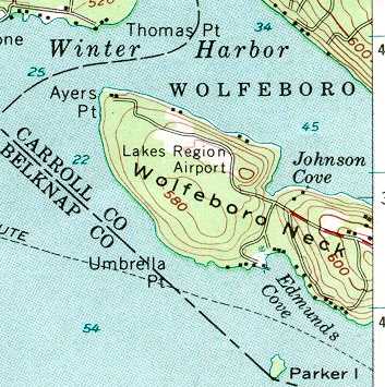
Lakes Region Airport (69NH), Wolfeboro, NH
43.59, -71.27 (North of Boston, MA)
Lakes Region Airport, as depicted on the July 1946 Boston Sectional Chart.
After the Hurricane of 1938 destroyed the huge maple syrup enterprise of his family,
Ralph Merwin Horn asked his father if he could finally build an airport on their 100+ acres of Wolfeboro Neck property.
With permission granted, Merwin pulled the stumps of hundreds of mangled maple trees.
Wolfeboro townspeople helped pull stumps too, with tractors & trucks.
Lakes Region Airport was not yet depicted on the 1945 Boston Sectional Chart (courtesy of John Voss).
According to a memorial plaque for Ralph Horn, he founded Lakes Region Airport in 1945.
The earliest depiction which has been located of Lakes Region Airport was on the July 1946 Boston Sectional Chart.
It depicted Lakes Region as a commercial/municipal airport, with an adjacent seaplane base.
Merwin married Eleanor, and the two put in exhausting hours - for 4 decades - to make the airport the busy enterprise it finally became.
Often there would be 4 floatplanes at the dock, dozens of aircraft at the tie-downs,
3 or 4 aircraft in the hangar for repairs/maintenance, and takeoffs & landings day & night.
The 1956 USGS topo map depicted Lakes Region Airport as a clearing, but without any other airport-specific features.
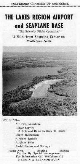
The earliest photo which has been located of the Lakes Region Airport
was an undated aerial view looking east from a 1956 Wolfeboro Chamber of Commerce brochure for the Lakes Region Airport & Seaplane Base.
The operators were listed as Merwin & Eleanor Horn.
The last aeronautical chart depiction which has been located of Lakes Region Airport was on the 1965 Boston Sectional Chart (courtesy of John Voss).
It depicted Lakes Region Airport as having a 1,500' unpaved runway & an adjacent seaplane base.
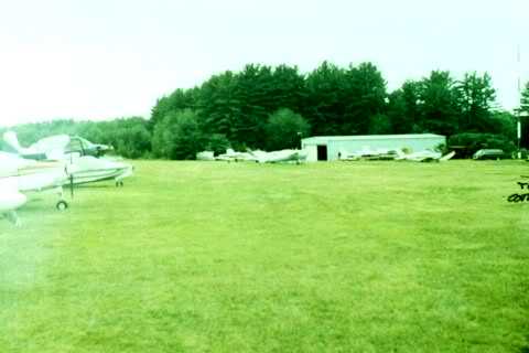
An undated photo of several planes & a hangar at Lakes Region Airport.
Acres Per Second reported that a second owner “paid $750,000 for the airport in 1995 - on a literal handshake with Ralph Horn.
Upon the 1995 airport tract's approval for development,
the Town of Wolfeboro was promised that half of the land would remain as original forest 'In Perpetuity'.”
Lakes Region Airport founder Ralph Horn passed away in 1997.
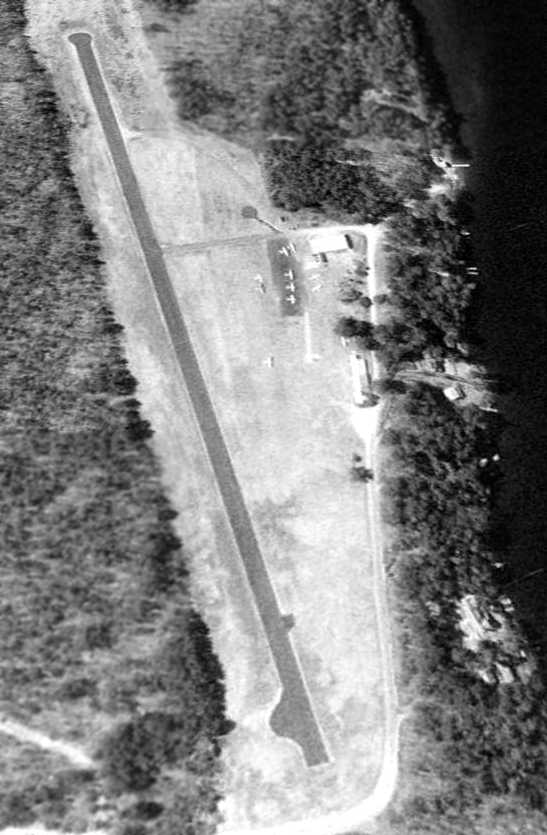
A 4/11/98 USGS aerial view looking northwest at Lakes Region Airport showed a healthy little general aviation airport,
with a single asphalt runway, a few small buildings, and 11 light aircraft.
John Zanchi recalled, “I owned an aircraft for which I rented one of the original T-hangars & had been a local year-round customer of the FBO.
I also assisted them when they needed an extra pilot, or simply a very light pilot, for scenic flights either in land or sea planes.
When we learned the airport was threatened with closure by the developer who had gained control
I was one of the 4 patrons of 8B8 who created the Committee to Save Lakes Region Airpark in 1999.
The town of Wolfeboro did want to see the airport & seaplane base preserved but the developer who had taken control from Ralph Merwin Horn
the one who wanted the airport closed, ASAP after Merwin passed away.”
John continued, “In spite of that, the airport would have been saved if the NH Attorney General's office, representing the NH DOT Div of Aeronautics,
which had a right of first refusal on the sale of the airport, had followed a course of action that we recommended which was to send a specific letter to the developer.
The State's attorney said our approach was incorrect, however a ruling against the NH Division of Aeronautics by the judge in the Superior Court of Southern Carroll County,
explicitly stated that if they had sent the letter we advised the Division of Aeronautics would have prevailed
and 8B8 would have been saved & operated by the Airport Authority that had been created by the NH legislature.
After that ruling sealed the fate of the airport the developer moved as quickly as possible to finish the shutdown of the airport & begin redevelopment as housing lots.
Eventually years later the bulk of the property was purchased by a member of the Marriott family when the developer was facing possible foreclosure.”
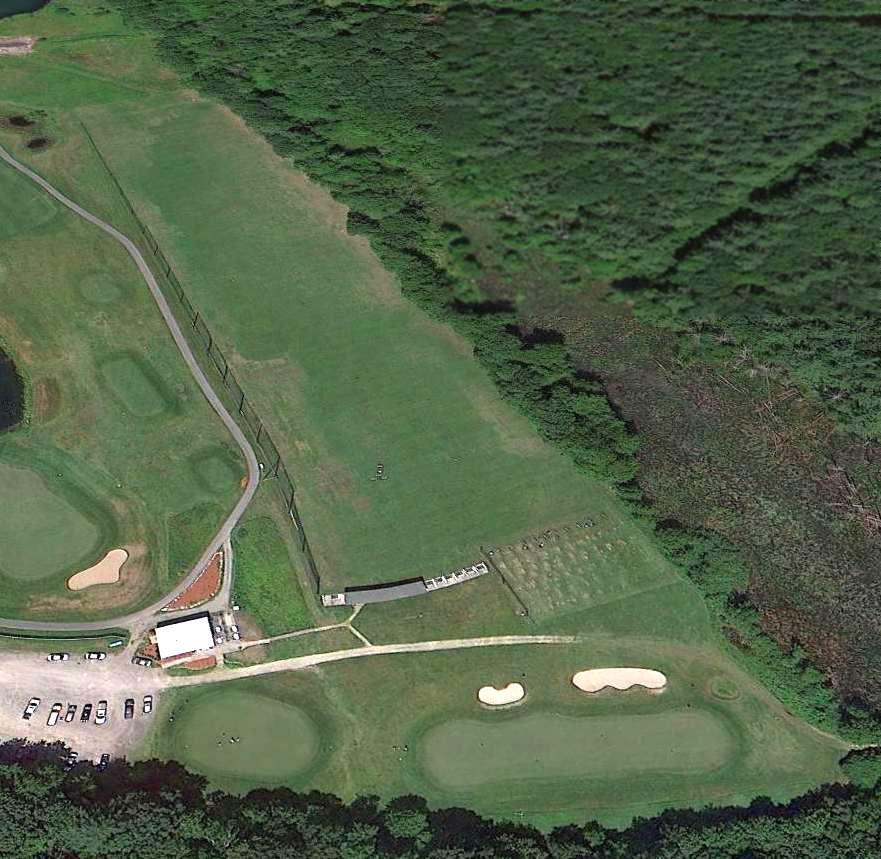
A 7/7/03 aerial view looking northwest at Lakes Region Airport showed only 3 light aircraft visible on the field.
In 2005 it was reported that the runway was scheduled to be torn up that year,
with 38 home sites having been laid out covering the airport property.
Paul H. reported in 2005, “I've been travelling to Winnipesaukee every August for the past 16 years.
For most of that time, Lakes Region Airpark was the way we got there.
Even now, three years after I last used the airport, it seems strange to get there any other way.
To me, the Airpark was the heart & soul of the Lakes Region. Wolfeboro meant Airpark.
The seaplanes tied up at the dock were evocative of the north woods.
Coming over the dark ridges of trees to the narrow little runway, surrounded on three sides by clear water,
it was obvious that I was a long way from Washington, DC, if not in another world entirely.”
Paul H. continued, “Over my 16 years, I got a once-a-year snapshot of the Airpark, and watched its fortunes rise & fall.
There was a golden period in the mid-1990s when there were lots of people there, even a Saturday hamburger cookout.
Then, there was a bleak period of deterioration & no fuel available.
In the late 1990s, there was a brilliant recovery, and the airport returned to health.
This was short-lived, and the facility went into its final decline.
At the end, I had to use my own stakes to tie the aircraft down
and it required a long negotiation to get a local car rental place to transport us between the airpark & the Sandy Island dock.
I felt disloyal not to use Wolfeboro, but the airport was becoming almost impossible to use as a gateway to the region.”
Paul H. continued, “This summer, they started digging up the runway.
Lots of little houses on the way, all built out of ticky-tacky & all looking just the same.
All part of a general pattern of removing beauty & individuality from Wolfeboro.”
Acres Per Second reported in 2005, “The entire airport property has been re-sold to the Marriott Family: The price is yet unknown.
The seller, an insider”, had purchased the airport in 1995 from Ralph Horn.
Acres Per Second continued, “The Marriotts own a huge chunk of contiguous waterfront properties on Tuftonboro Neck (in sight of the airport)
and have been looking to buy abutters' properties which have much calmer waters on which to waterski.
One recent photo shows one end of the existing estate, so the Marriotts aren't likely to rebuild the airport or to replant the area in forest.
Since groundbreaking & dynamiting early last year, that one lakefront lot is still under construction with the usual McMansion
on a lot that extends about 300' wide, and extends nearly 400' from the water's edge.
Lot sales have been non-existant, with the 'model home' rarely visited.
It may have been that rugged, winding, jarring start to a 4-mile-ride to Wolfeboro that failed the developer.
At only 20', the lake is not particularly deep between the paired estates (Ayer's Point to Thomas Point),
so a bridge constructed between the two Marriott mega-estates can't be ruled out.”
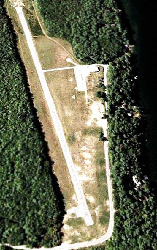
A 10/7/06 aerial view showed the airport property in a state of redevelopment,
with most of the runway pavement having been removed at some point between 2003-2006,
along with one airport building.
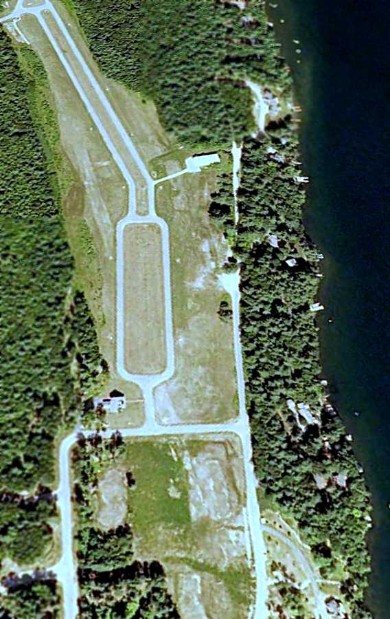
A 7/5/09 aerial view looking northwest at the site of Lakes Region Airport showed that portions of the paved runway remain,
but the majority had been cleared & covered by new streets for a housing development, yet to be built.
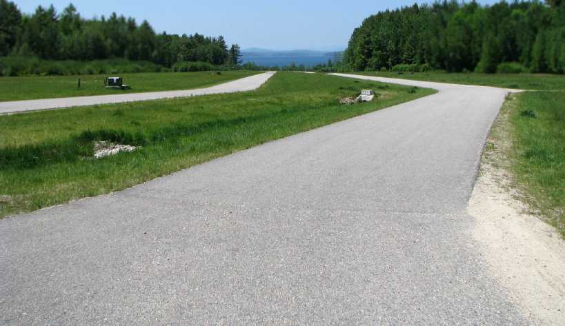
A 2010 photo by Kevin Porter looking west along the former runway at the site of Lakes Region Airport.
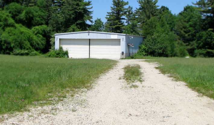
A 2010 photo by Kevin Porter looking north at a former hangar which remains at the site of Lakes Region Airport.
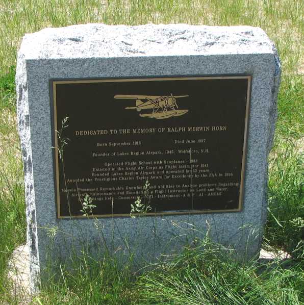
A 2010 photo by Kevin Porter of a 1997 memorial plaque dedicated to Lakes Region Airport founder Ralph Merwin.
Kevin Porter reported on a visit to the site of Lakes Region Airport in 2010:
“My GPS directed me to the airport with no indication that it had closed, but I arrived to find it in the condition depicted in Google Maps.
Some time between my GPS' last update in 2008 and May of 2010, the airport has been demolished & is in the process of being turned into a subdivision of houses.
A number of roads & utility conduits have been constructed across the former runway, and a demonstration house has been built at the west end of the runway.
The only hints of the land's former use as an airport are a small hangar along the tree line, and a plaque in place in the grass at the west end of the road network.”
As of 2011, the former airport was being marketed as a development called “Grand View Commons”.
The site of Lakes Region Airport is located northwest of the intersection of Forest Road & Broadside Road.
____________________________________________________
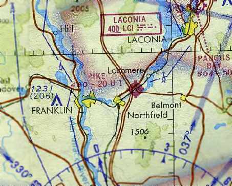
Pike Airfield (8B7), Tilton, NH
43.46, -71.56 (Northwest of Boston, MA)
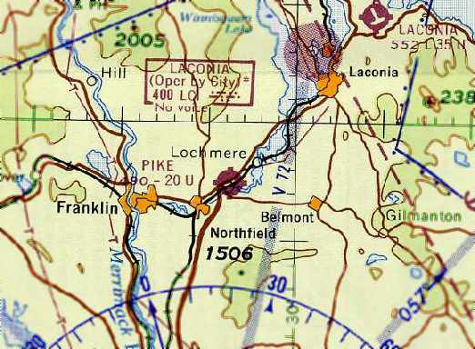
The Pike Airfield, as depicted on the March 1963 Boston Sectional Chart (courtesy of Chris Kennedy).
According to Cynthia Pike Baron, the Pike Airfield “was originally built to service 2 small aircraft:
one owned by the company & the other by one of its Vice Presidents.
The runway was used almost daily to run parts, supplies, or people to various jobs & locations
throughout New Hampshire, Vermont and Upstate New York.”
It was evidently established at some point between 1962-63,
as it was not yet depicted on a 1956 aerial photo nor listed among active airfields in the 1962 AOPA Airport Directory (according to Chris Kennedy).
The earliest depiction of the Pike Airfield which has been located
was on the March 1963 Boston Sectional Chart (courtesy of Chris Kennedy).
It depicted Pike as a public-use airfield having a single east/west paved 2,000' runway.
Pike Airfield was listed in the 1963 AOPA Airport Directory (according to Chris Kennedy).
According to Lou Maglio, “It was owned by Milo Pike who had the Pike Construction Company Asphalt Company & Paving Company.
It was listed on the old sectional as 'Pike'.
I made a few approaches by it in 1970 as my folks had a cottage up the street on Lake Winnesquam.
It was about a 1,600' paved strip with trees / power lines on each end.
I never landed as I was too 'green' & continued on to Laconia!”
The January 1971 NY Sectional Chart (courtesy of Chris Kennedy)
depicted Pike as a public-use airfield having a single east/west paved 2,000' runway.
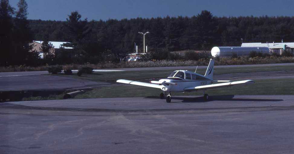
The earliest photo which has been located of the Pike Airfield was a 5/2/74 USGS aerial view.
It depicted Pike as having a single northeast/southwest runway.
Pike Airfield was listed in the “Low Use” section of the 1979 Flight Guide (according to Chris Kennedy).
A 5/3/81 USGS aerial view depicted Pike Airfield as having a single northeast/southwest runway.
What may have been one light single-engine aircraft was visible on the north side of the eastern end of the runway.
The last directory reference to the Pike Airfield which has been located
was its listing in the 1982 AOPA Airports USA Directory (according to Chris Kennedy).
Its status had also changed to a private airfield.
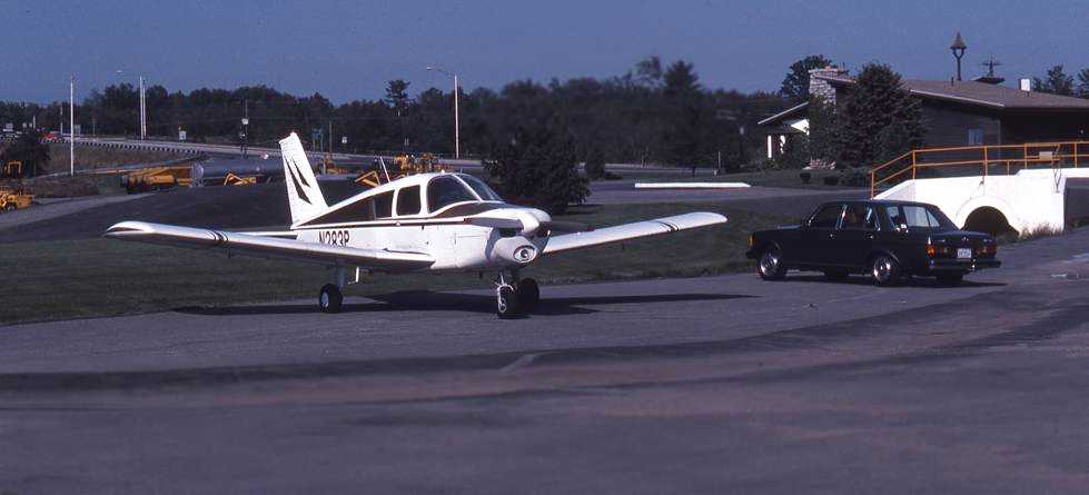
An 8/15/82 photo by Dave Murphy of his Piper “Cherokee 140 sitting in the office parking lot (not 'ramp'!) at the southwest end of the runway.
I had flown up from Mansfield to visit friends who have a home in Salisbury. Pike was the closest field to their place.
I called the folks at Pike & got permission to land & stay overnight.
I could have met my friends at Laconia, but what fun would that have been?
I regret not taking more pics of the surrounding area, but at the time I was interested in the plane with the Tonka-toys in the background!”
An 8/15/82 photo by Dave Murphy of his Piper Cherokee 140 at Pike Airfield.
Dave remarked, “You can see a portion of the runway & displaced threshold.
The drainage ditch flows under the runway & then under the railroad.
The approach to this end was over power lines & Route 140, which was elevated to cross over the railroad tracks.
There was a dip coming off the runway then going up a slight slope to the lot.
The runway itself may have had a camber to it to help drain rain off.
I think the runway was level with the tracks, which can't be seen behind the bushes.”
According to Cynthia Pike Baron, “In the early to mid-1980s,
the plane was replaced with a Bell Jet Ranger helicopter & the runway had pretty much seen its last days.”
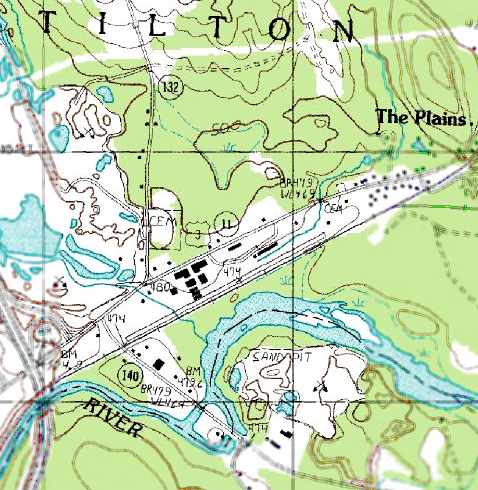
The 1987 USGS topo map still depicted a single 2,900' northeast/southwest paved runway,
but it was unlabeled, which presumably indicates the field was abandoned by that point.
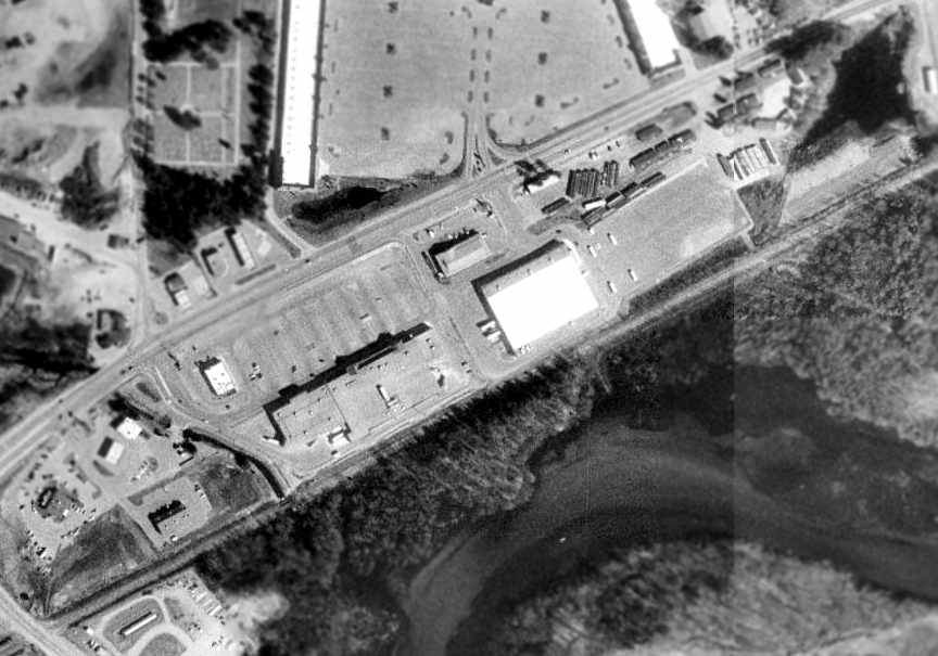
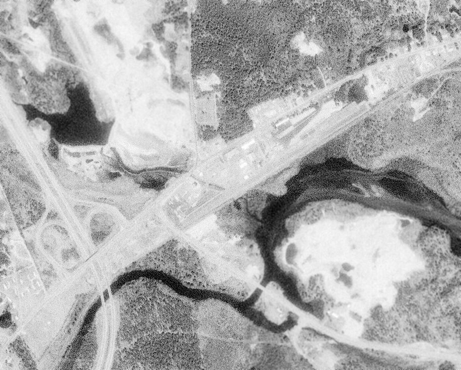
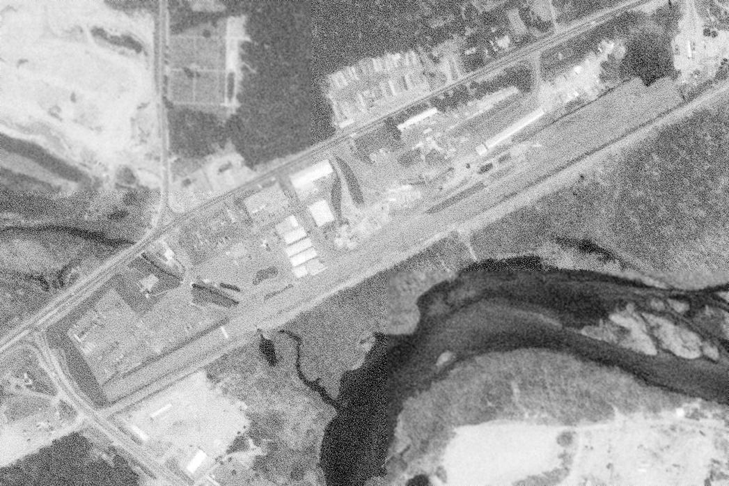
As of the 1998 USGS aerial photo,
several buildings have covered much of the location of the former Pike runway.
Only a small portion at the northeast corner of the former runway still appeared to remain intact.
A 2006 photo by Lou Maglio, looking northwest along the location of the former Pike runway.
Lou reported that the site of the former Pike airfield
“is now the access road behind a Super Stop & Shop and a BJ's Warehouse.”
A circa 2007 aerial view looking east at the last remnant of the Pike Airfield – a small section of runway pavement on the east end.
The site of Pike Airfield is located on the south side of Route 3, just east of its intersection with Interstate 93.
____________________________________________________
Cibor Airport (NH28) / Rye Airfield, Rye, NH
43.01 North / 70.8 West (Northeast of Boston, MA)
Cibor Airport, as depicted on the 1985 USGS topo map.
Photo of the airport while open has not been located.
This small airfield was evidently established at some point after 1962,
as it was not yet depicted on a 1962 aerial photo.
According to Tom, the field was “named for it's builder Jake Ciborowski.
Jake was a little arrogant & thought he'd do what he wanted.
Apparently forgot the town could make laws.”
According to Mike Wheet, the members of a local radio-controlled model airplane group reported
“that the field was constructed at some point in the very early 1960s,
but the town of Rye almost immediately slapped a severe restriction on the number of takeoffs & landings at the field.
The restriction effectively prevented anything but personal use by the field owner,
and the airport was closed sometime the late 1960s.
The paved single Runway 10/28 had about 2,500 usable feet,
with paved displaced thresholds of at least 500' at each end.”
No airfield at this location was depicted on the March 1963 Boston Sectional Chart (according to Chris Kennedy)
or the January 1971 New York Sectional Chart (according to Chris Kennedy).
Mike reported that the club “R/C Aces... were using the field for flying radio controlled models in the early 1970s.”
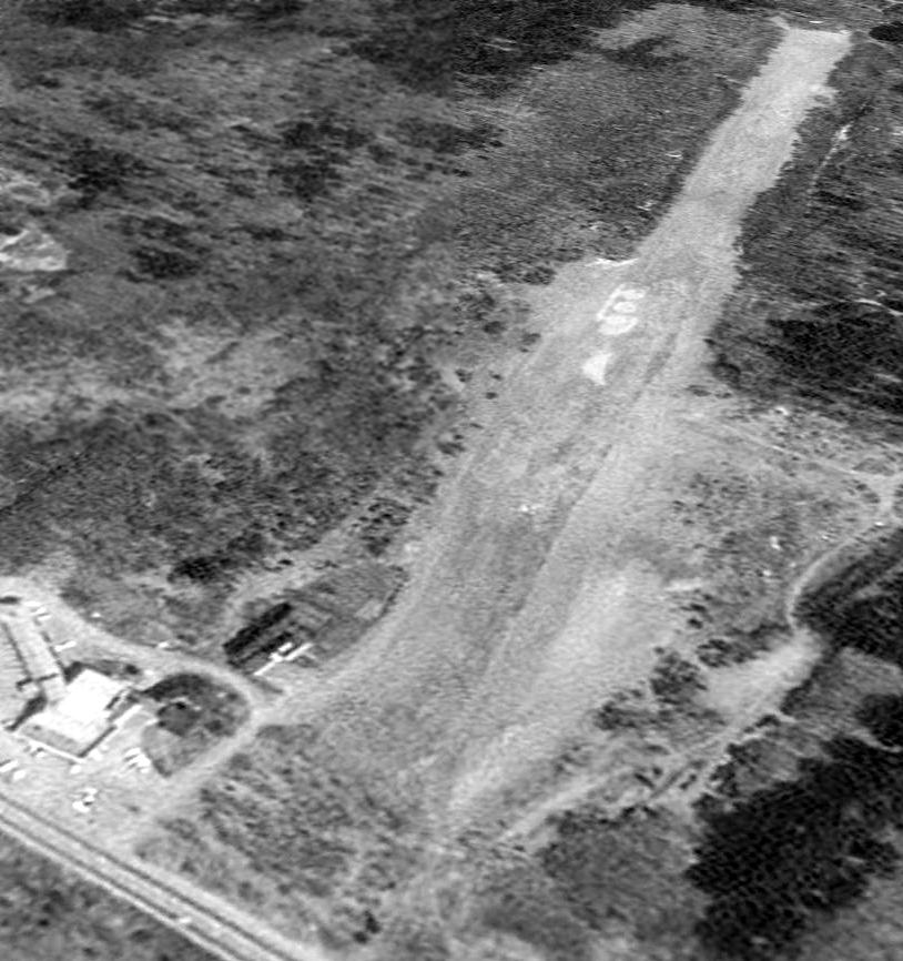
The earliest photo which has been located of Cibor Airport was on a 1974 aerial photo,
which depicted a single unpaved east/west runway, with two closed-runway “X” symbols along the west end.
A single small building (hangar) was located on the northwest side,
near was visible possibly one single-engine aircraft.
Rob Sargent recalled, “I lived across the street in Rye [from] March 1975 – July 1977, and I never saw or heard a takeoff or landing there.
A bunch of us from Pease AFB used to spend Saturdays & Sundays flying model rockets there & once in awhile saw some radio-controlled planes flying.
There was a small Quonset hut on the left but it was abandoned.”
Apparently Cibor Airport was reopened as a private field at some point between 1971-76,
as it was listed as a private field in the 1976 AOPA Airports USA Directory (according to Chris Kennedy).
It described the field as having a single 2,500' asphalt Runway 9/27,
and the field's status was listed as "Private. Closed to public."
The last photo which has been located showing an aircraft at Cibor Airport was a 1978 aerial photo,
which depicted a one single-engine aircraft on the northwest side.
The last listing which has been located of Cibor as an active airport
was in the 1982 AOPA Airports USA Directory (according to Chris Kennedy).
It described the field as having a single 2,500' asphalt Runway 10/28,
and the field's status was listed as "Private. Closed to public."
Cibor Airport was evidently completely closed by 1984,
as it was no longer depicted at all on the 1984 Sectional Chart (according to Mike Wheet).
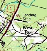
The 1985 USGS topo map still depicted a single runway,
but it was labeled simply as “Landing Strip”,
which most likely indicated that the airfield had closed by that point.
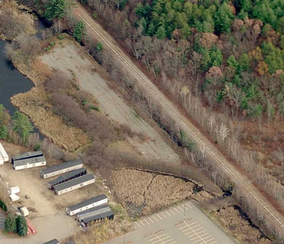
The earliest photo which is available of Cibor Airport was a 4/28/92 USGS aerial view looking northeast,
in which the airport remained intact, but there was no sign of any recent aviation usage.
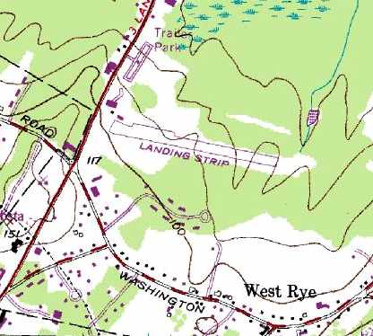
The 1993 USGS topo map still depicted a single 2,500' east/west runway, labeled simply as "Landing Strip",
along with a few small buildings along the northwest side of the property.
Ironically, Mike Wheet reported that Cibor Field was still represented in Microsoft Flight Simulator 2002.
A 2003 aerial photo showed that Airfield Road & a large building had been built over the location of the runway.
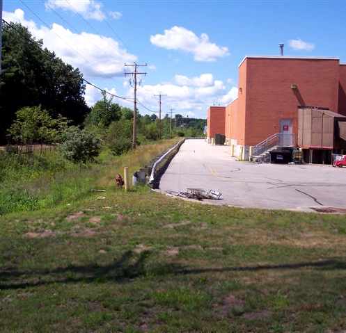
As of 2003, the site of the former airport had become the site of the “Rye Airfield” skatepark.
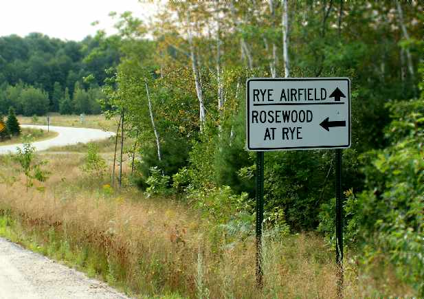
A 2005 photo by Rich Peabody of a road sign that remains for “Rye Airfield”.
Rich reported, “Apparently the builder of Cibor
decided that it was a good thing to chop the trees at one end of the strip...
and apparently he did so... but the property with the trees belonged to a local judge.
Things apparently deteriorated from there...
the field was slapped with restrictions because of the proximity to Pease [AFB] as well,
and the 'war' raged for about 10 years.”
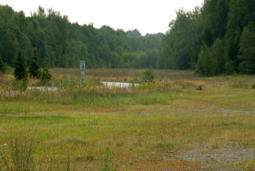
A 2005 photo by Rich Peabody looking southeast from the northwest end of the former Rye Airfield.
Tom reported in 2006 that the former airfield “is now the site of several large structures
and is used as an indoor/outdoor skateboard park.
It could in no way function even as an emergency 'landing strip'.”
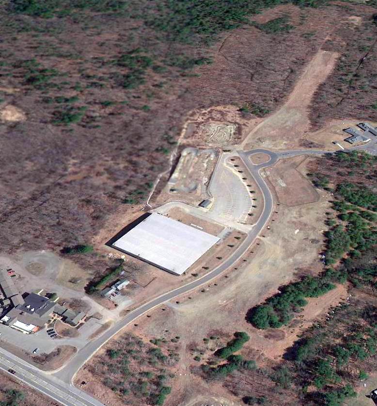
A 4/7/13 aerial view looking northeast showed the eastern runway end remained recognizable.
It also appears that several airport-related buildings remain on the northwest side (bottom-left).
The site of Cibor Airport is located northeast of the intersection of Lafayette Road & Washington Road.
____________________________________________________
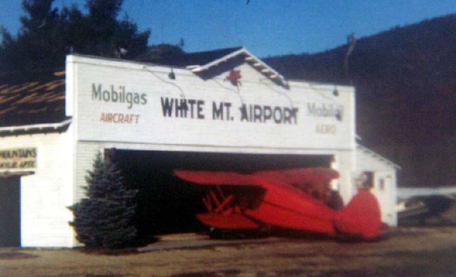
White Mountain Airport (CWN), North Conway, NH
44.02, -71.11 (North of Boston, MA)
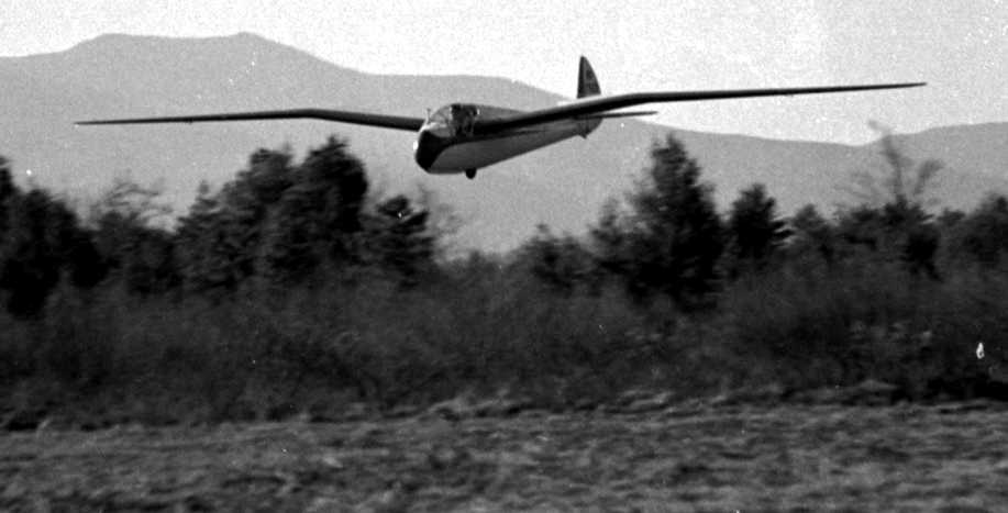
A 10/25/38 photo of Lewin Barringer making the 1st wave soaring flight in the U.S., conducted from the White Mountain Airport.
According to Wylie Apte, Jr., what would eventually become White Mountain Airport
started out as a site for weekend barnstorming in 1928.
"It was then a horse racing track.
As you may know racetracks were often used for landing & takeoffs as it was a known prepared surface.
My father, Wylie Sr (commercial license # 392) officially moved there with an airplane operation in 1930;
the field was then improved under the WPA projects under the Roosevelt era."
The Department of Commerce's 1934 Airport Directory (courtesy of Chris Kennedy)
described White Mountain Airport as a commercial airport having a single 1,800' sod & sand runway.
On 10/25/38, Lewin Barringer made the 1st wave soaring flight in the U.S., from the White Mountain Airport.
He took off from the North Conway airfield & reached an altitude of 9,500' by "climbing in the holes between the clouds."
An undated photo of an Ibis sailplane (designed by Harland Ross) in front of the White Mountain Airport hangar.
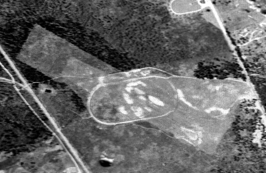
A 6/1/39 aerial view depicted White Mountain Airport as having a rectangular northwest/southeast grass runway
extending outward from the oval horse racing track which predated the airport.
Two small buildings sat on the west side of the field.
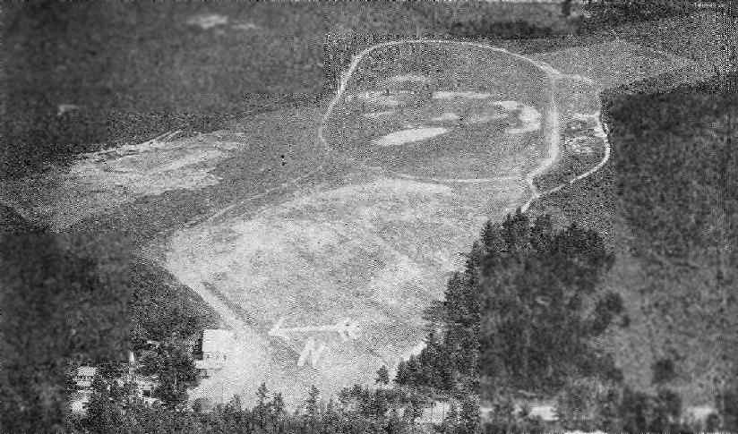
An aerial view looking east at the White Mountain Airport,
from the Airport Directory Company's 1941 Airport Directory (courtesy of Chris Kennedy).
It prominently depicted the oval horse racing track which predated the airport,
with the airport's runway extending away from the track toward the northwest & southeast.
The directory described White Mountain as a commercial airport
having an irregularly-shaped 2,300' x 800' grass landing area,
with "additional area under development."
The field's name was said to be painted on its hangar roof.
An undated photo of a ski-equipped Waco UKC biplane in front of a White Mountain Airport hangar.
According to Wylie Apte, Jr. recalled, "The property was unofficially owned by the town of Conway.
My father operated it as an airport yearly as a tenant until WW2
when he was required to close & he was recalled to active AAF duty patrolling the East coast for enemy submarines."
The 1942 USGS topo map labeled the site simply as "Airport", but did not depict any runways.
Instead it still depicted the oval horse racing track which predated the airport.
A 10/10/42 aerial view looking north from the 1945 AAF Airfield Directory (courtesy of Scott Murdock)
depicted White Mountain Airport as having a single unpaved northwest/southeast runway.
The 1942 Lewiston Sectional Chart (courtesy of Mike Keefe)
depicted White Mountain as a commercial airport.
The 1945 AAF Airfield Directory (courtesy of Scott Murdock) described White Mountain Airport
as a 120 acre triangular property having 2 sod runways, measuring 2,300' northwest/southeast & 2,000' east/west.
The field was said to have a single 60' x 50' wooden hangar,
and to be owned & operated by private interests.
Wylie Apte, Jr. recalled, "After the war, the town called him [Wylie Apte Sr.] in & said there was no future in aviation
and therefore he had to vacate or purchase the property.
He struggled & bought the airport at a time when financing anything was practically unheard of.
Improvements followed as aviation grew,
private donations added to the airport's growth as bigger & better aircraft came along.”
A 1955 photo of a pretty 1939 Waco VKS-7F, NC31651, in front of the White Mountain Airport hangar (courtesy of Jonathan Westerling).
According to Wylie Apte, “A new paved runway was installed in 1961, 3,000'.
Business improved to where it became a major attraction for tourism & businesses,
and commuters started buying vacation homes & depending on the airport."
The 1962 AOPA Airport Directory described White Mountain Airport as consisting of a 3,000' asphalt Runway 15/33.
The operator was listed as Wylie Apte.
A 1963 aerial view by David Cullinan looking north at the White Mountain Airport.
Dennis Yanez recalled, “White Mountain Airport... I flew out of that strip in September 1963
on a 2 hour fly around the area in a Cessna 170 called 'The Green Grasshopper' with the field operator on a sightseeing trip.
Also subsequently flew into White Moutain several times doing cross-countries for my Private Pilots License. Nice little operation!”
Tom Kenny recalled, “Wylie Apte Jr (Bunky) & my dad were great friends before my dad passed away back in 1967.
As a kid I used to go up flying in the old Wacos often (flying over 4th of July parade was fantastic).
Some of my best memories are at that old airport.
In the 1960s it was a basic strip & little log cabin office with vintage Coke machine out front.
Nothing like hanging out at the airfield on a warm summer day.”
The 1965 Boston Sectional Chart (courtesy of John Voss) depicted White Mountain Airport
as having a 2,900' paved runway & an NDB radio beacon on the field.
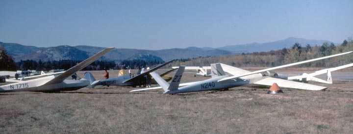
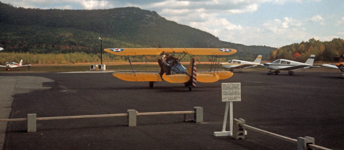
An undated photo of multiple gliders at White Mountain Airport,
as part of the annual Wave Camps, which were organized by Allan MacNicol & held at White Mountain from 1966 until the airport was sold.
The 1968 Boston Sectional Chart (courtesy of Mike Keefe) depicted White Mountain Airport
as having a 2,900' paved runway & an NDB radio beacon on the field.
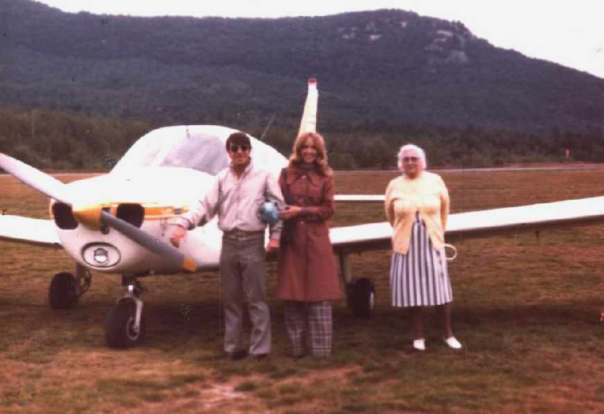
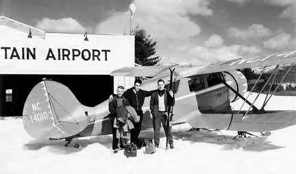
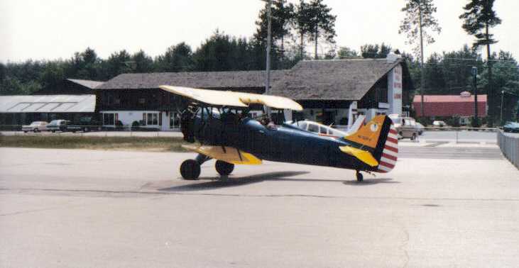
A 1971 photo of Lou Maglio, his future wife and her grandmother in front of a Piper Warrior at White Mountain Airport.
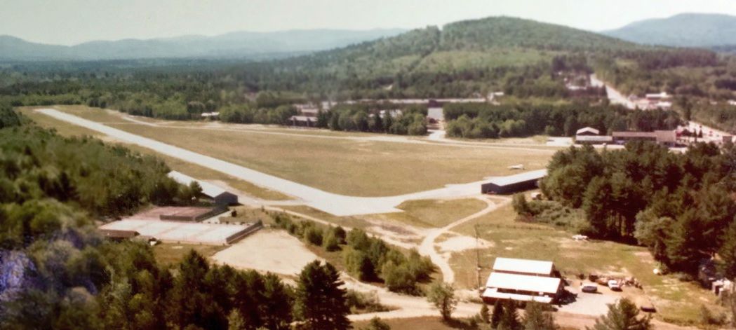
A circa 1970s aerial view by Dick Bicknell looking south at White Mountain Airport.
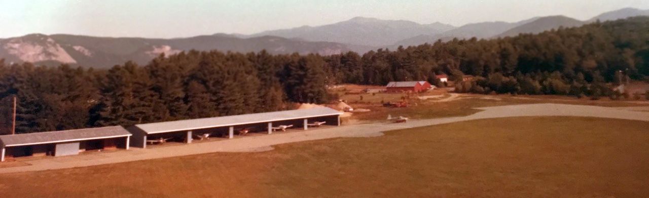
A circa 1970s aerial view by Dick Bicknell looking northwest at planes inside the hangars of White Mountain Airport.
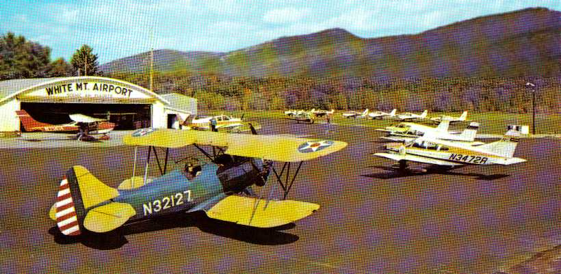
A mid-1970s view of a beautiful Waco biplane & other aircraft in front of the White Mountain Airport hangar (courtesy of Matt Deering).
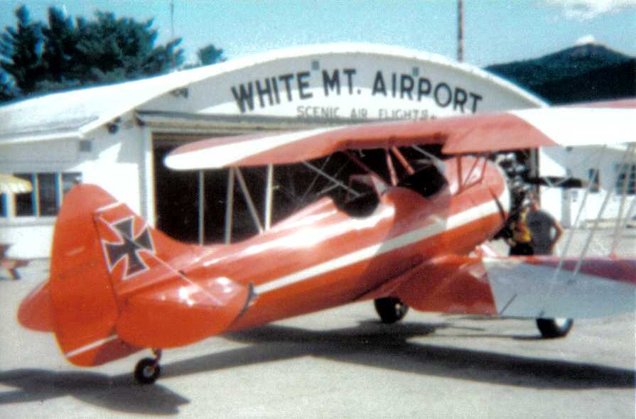
An undated (circa 1970s?) photo of a Waco biplane painted to resemble the Red Baron in front of the White Mountain Airport hangar (courtesy of Matt Deering).
An undated (circa 1970s?) photo of a Waco biplane painted in American military markings at White Mountain Airport (courtesy of Matt Deering).
A 4/19/77 photo courtesy of David Cullinan of a beautiful Waco biplane at the White Mountain Airport.
The last photo which has been located showing White Mountain Airport in operation was a 1978 photo of a Bell 47 helicopter & a Piper Cherokee (courtesy of Matt Deering).
The 1982 AOPA Airport Directory (courtesy of Ed Drury)
described the runway configuration in much the same manner,
and listed the operator as White Mountain Airways.
However, apparently by this time White Mountain had changed to a private field,
as the remarks said, "Private. Use at own risk. PPR from owner before landing.
Closed during winter months. Runway not plowed."
Jeffrey Geibel, CFII, said, "I flew out of it in the summer of 1982.
The runway was parallel to the main road (Highway 302) and slightly east,
but perhaps only 100 yards or so off the road."
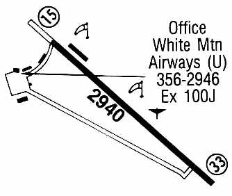
The 1985 Flight Guide (courtesy of Chris Kennedy) depicted White Mountain Airport
as having a single 2,940' paved Runway 15/33,
with two taxiways leading to a ramp on the west side with several adjacent buildings.
One of those buildings was depicted as the location of White Mountain Airways.
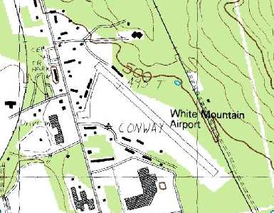
The 1987 USGS topo map depicted White Mountain Airport as having a taxiway leading from the northwest end of the runway to the south,
with several buildings (hangars?) along the west side of the taxiway.
Wylie Apte, Jr. said "I was the last & final owner of this airport,
taking over from my father who started the airport.
It was closed down after a forced sale due to being taxed out of existence
by the town's greediness to raise property taxes."
According to Wylie Apte, Jr., the airport closed in the Summer of 1988.
Jeffrey Geibel said, "There is (or was) a heliport left over from the airport circa 1995 when I was up there,
but that may have gone, too.
I believe there's a street called "Airport Square" or something like that (right of the main drag)
which was the entrance road to the airport."
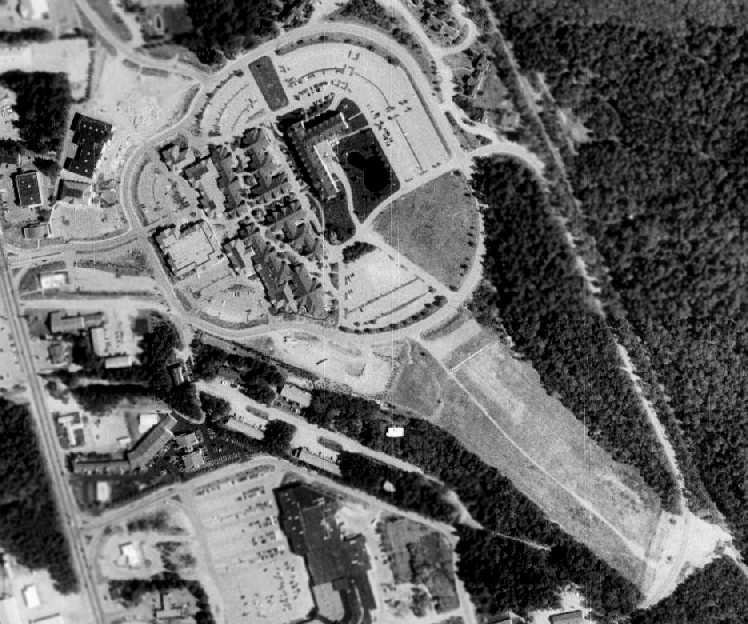
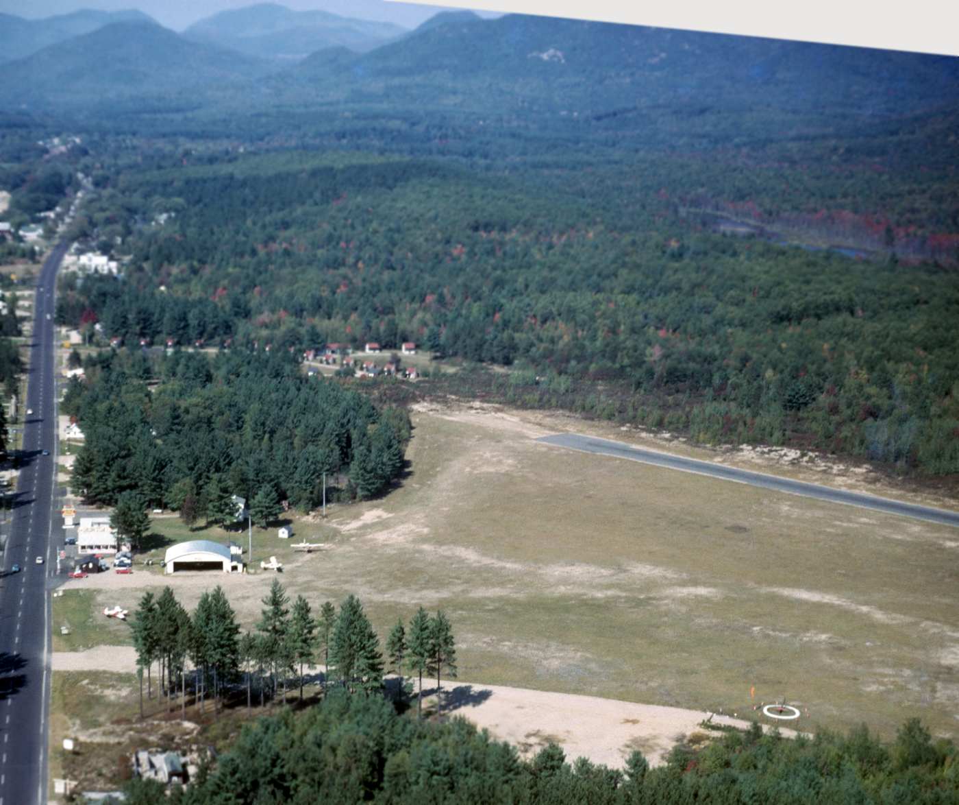
As seen in the 1999 USGS aerial photo,
the site of the former airport has been covered by a factory outlet center, several condo units,
and a Sheraton Hotel (since renamed the North Conway Grand Hotel)
The southeastern half of the runway still remained visible in the above photo, however.
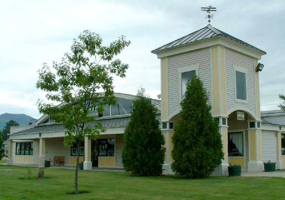
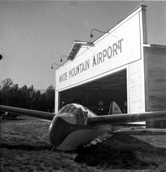
A 2003 photo by Mike Fesko of the former hangar of the White Mountain Airport,
which remains in use as a retail outlet. Note the biplane wind indicator on the roof.
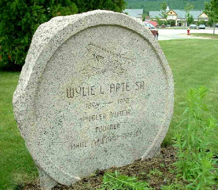
A 2003 photo by Mike Fesko of the plaque at the site of the former White Mountain Airport which honors founder Wylie Apte Sr.
According to Wylie Apte, Jr., the original main hangar (built by Apte) also still remains.
It is the silver-roofed Quonset hut visible just below the entrance road along the left side of the above photo.
As of 2003, it was being reused as an Orvis outlet.
The site of White Mountain Airport is located northeast of the intersection of Route 302 & Route 16,
two miles southeast of North Conway.
____________________________________________________
Since this site was first put on the web in 1999, its popularity has grown tremendously.
That has caused it to often exceed bandwidth limitations
set by the company which I pay to host it on the web.
If the total quantity of material on this site is to continue to grow,
it will require ever-increasing funding to pay its expenses.
Therefore, I request financial contributions from site visitors,
to help defray the increasing costs of the site
and ensure that it continues to be available & to grow.
What would you pay for a good aviation magazine, or a good aviation book?
Please consider a donation of an equivalent amount, at the least.
This site is not supported by commercial advertising –
it is purely supported by donations.
If you enjoy the site, and would like to make a financial contribution,
you
may use a credit card via
![]() ,
using one of 2 methods:
,
using one of 2 methods:
To make a one-time donation of an amount of your choice:
Or you can sign up for a $10 monthly subscription to help support the site on an ongoing basis:
Or if you prefer to contact me directly concerning a contribution (for a mailing address to send a check),
please contact me at: paulandterryfreeman@gmail.com
If you enjoy this web site, please support it with a financial contribution.
please contact me at: paulandterryfreeman@gmail.com
If you enjoy this web site, please support it with a financial contribution.
____________________________________________________
This site covers airfields in all 50 states.