
Abandoned & Little-Known Airfields:
Northeastern North Carolina
© 2002, © 2016 by Paul Freeman. Revised 11/15/16.
This site covers airfields in all 50 states: Click here for the site's main menu.
____________________________________________________
Please consider a financial contribution to support the continued growth & operation of this site.
Elizabeth City Municipal (1st location) (revised 10/27/07) - Elizabeth City Municipal (2nd location) (revised 11/15/16)
Halifax County Airport (revised 1/21/16) - Harris Airport (added 4/21/13) - Harvey Point NAAS (revised 8/24/14) - Weeksville NAS (revised 4/21/13)
____________________________________________________
Harris Airport, Williamstown, NC
35.82, -77.06 (East of Raleigh, NC)
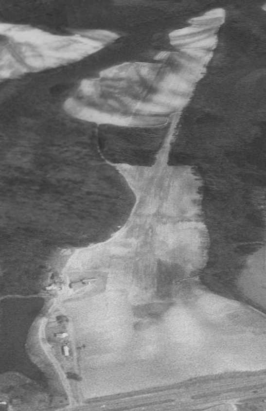
Harris Airport, as depicted on a 4/10/74 aerial photo (courtesy of Dallam Oliver-Lee).
This small general aviation airport was evidently established at some point between 1964-74,
as it was not yet depicted on a 1964 aerial photo (courtesy of Dallam Oliver-Lee).
The earliest depiction which has been located of Harris Airport was on a 4/10/74 aerial photo (courtesy of Dallam Oliver-Lee).
It depicted the field as having a single unpaved northwest/southeast runway.
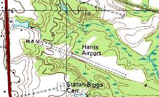
The only topo map depiction which has been located of Harris Airport was on the 1982 USGS topo map (courtesy of Dallam Oliver-Lee).
It depicted Harris Airport as having a single unpaved northwest/southeast runway.
The last photo which has been located showing Harris Airport still intact was a 1993 USGS aerial view looking east.
It depicted several small buildings on the northwest side of the field.
Harris Airport was evidently closed at some point between 1993-98,
as a 1998 aerial photo (courtesy of Dallam Oliver-Lee) showed that the new US Route 13/64 had been constructed over the western portion of the runway,
and the eastern portion of the airfield had been turned into a pond.
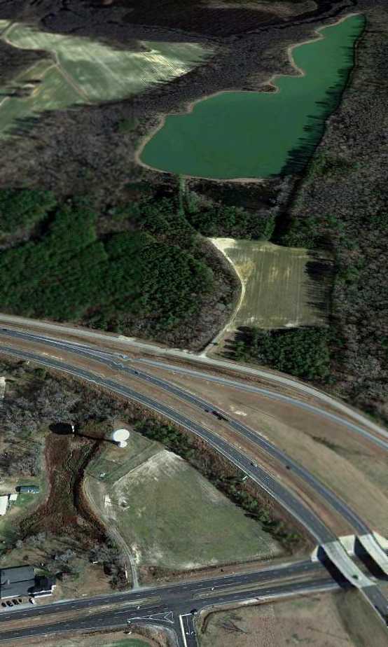
A 2012 aerial view looking east showed the only trace remaining of Harris Airport
to be alignment of the former runway along the southern side of the pond.
The site of Harris Airport is located east of the intersection of Route 17 & Interstate 64.
____________________________________________________
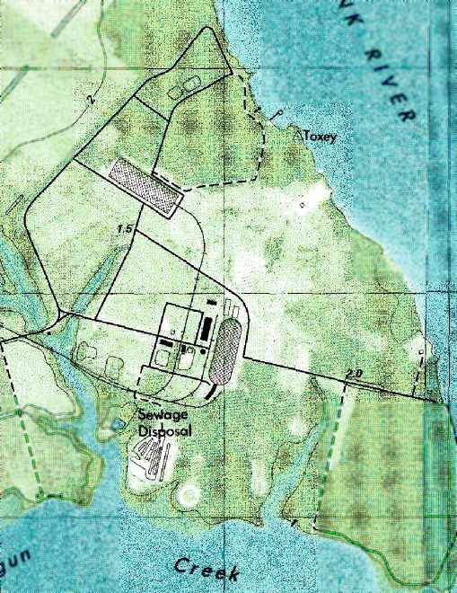
Halifax County Airport (KRZZ), Roanoke Rapids, NC
36.44 North / 77.71 West (Northeast of Raleigh, NC)
Halifax County Airport, as depicted on a 4/20/51 USGS aerial photo (courtesy of Dallam Oliver-Lee).
The Halifax County Airport was activated in November 1946, according to its FAA Airport/Facility Directory data.
The earliest depiction which has been located of the Halifax County Airport was a 4/20/51 USGS aerial photo (courtesy of Dallam Oliver-Lee).
It depicted the field as having 3 unpaved runways.
A 6/18/61 USGS aerial photo (courtesy of Dallam Oliver-Lee) appeared to show Halifax County as still having unpaved runways.
The earliest map depiction which has been located of the Halifax County Airport was on the 1963 USGS topo map.
The 1968 Flight Guide (courtesy of Bob Levittan) depicted Halifax County Airport
as having a paved 3,000' Runway 5/23 & 2 grass crosswind runways.
A 3/12/73 USGS aerial photo (courtesy of Dallam Oliver-Lee)
showed that the northeast/southwest runway had been paved at some point between 1961-73.
The 1974 USGS topo map depicted both the Halifax County Airport
(having a single paved northeast/southeast runway & 2 grass crosswind runways),
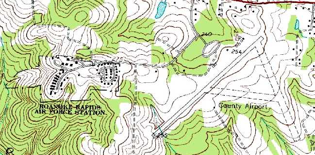
as well as the adjacent Roanoke Rapids Air Force Station (apparently a support installation for a radar site).
A 2/27/94 USGS aerial view looking southwest at Halifax County Airport depicted several light planes on the ramp on the northwest side of the field.
The last photo which has been located showing the Halifax County Airport still in use was a 6/26/08 aerial view,
which depicted 2 light single-engine aircraft on the ramp on the northwest side of the field.
In February 2009 the larger Halifax-Northampton Regional Airport opened several miles the the southeast,
at which point the Halifax County Airport presumably closed.
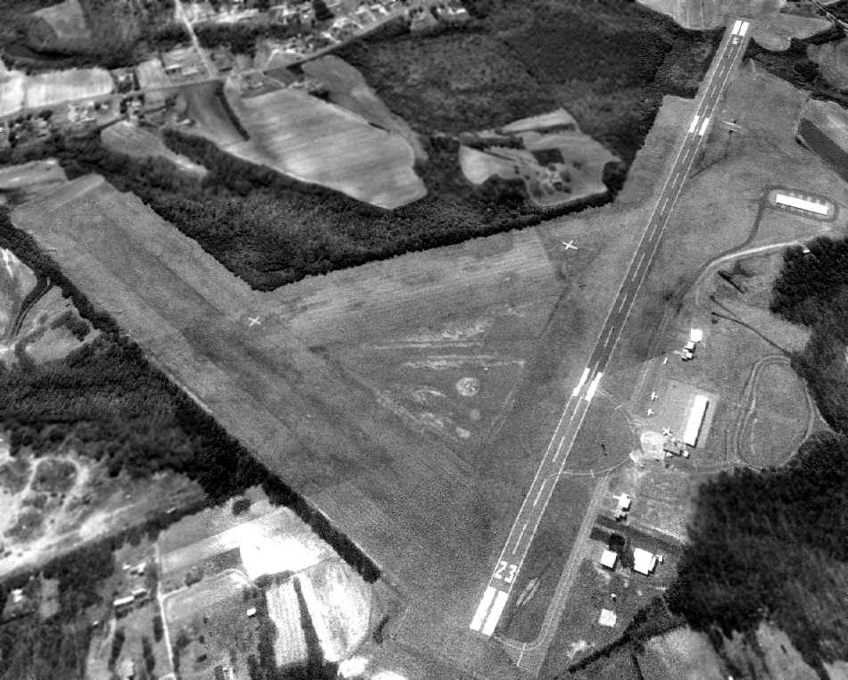
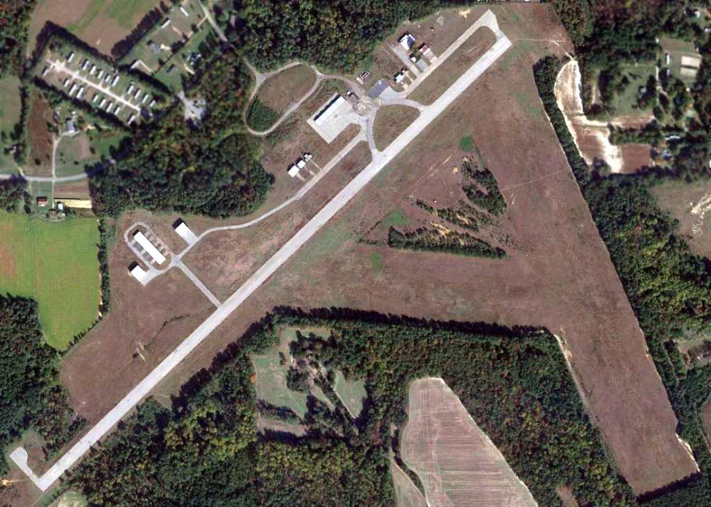
A 5/31/09 aerial view depicted Halifax County Airport as still remaining completely intact, yet appearing abandoned.
As of September 2010 the Halifax County Airport was still listed in the FAA Airport/Facility Directory,
but with the remark “Airport closed permanently.”
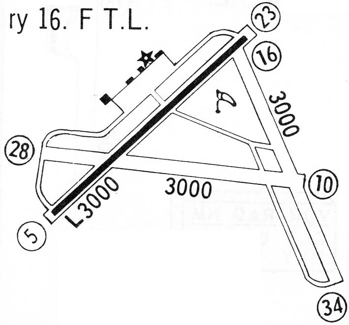
It was described as having a 4,006' asphalt Runway 5/23 & a 2,100' turf Runway 16/34.
The airport was described as being owned by the City of Roanoke Rapids,
and the manager was listed as Ralph Johnson.
The field was said to have a total of 24 based aircraft,
and to conduct an average of 86 takeoffs or landings per day.
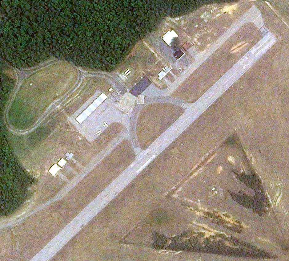
A 10/22/12 aerial view (courtesy of Dallam Oliver-Lee) depicted Halifax County Airport as still remaining completely intact, yet appearing abandoned.
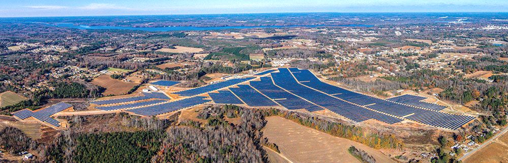
A circa 2014-2016 aerial view looking north (courtesy of Christopher Sowada) of the solar power facility which was commissioned in 2014 on the site of the Halifax County Airport.
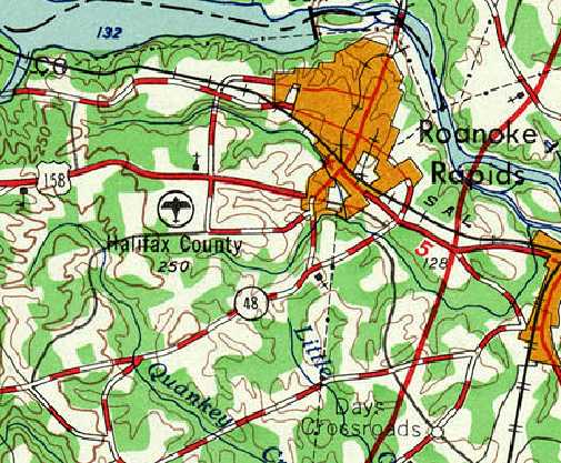
Halifax County Airport is located southeast of the intersection of Route 158 & Airport Road.
____________________________________________________
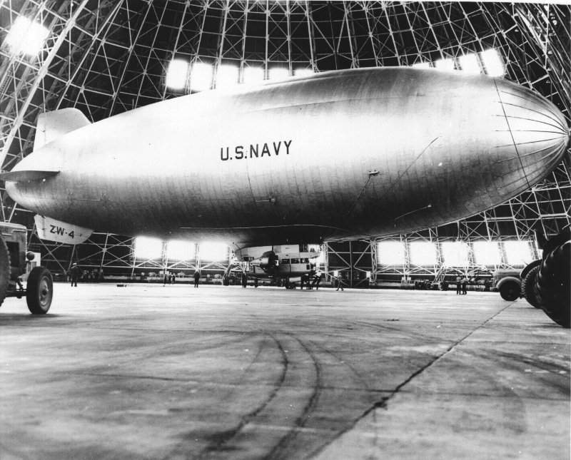
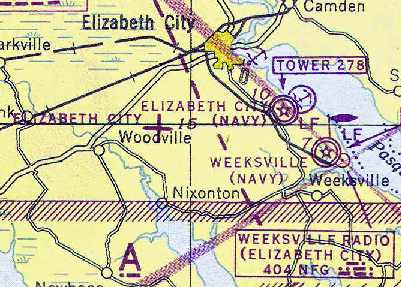
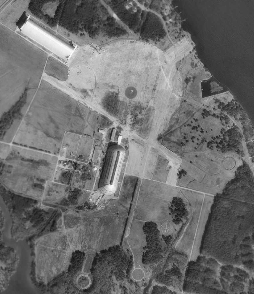
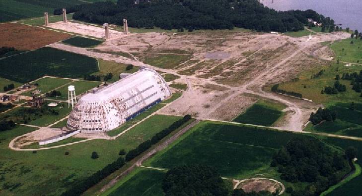
Weeksville NAS, Weeksville, NC
36.23 North / 76.13 West (Southeast of Elizabeth City, NC)
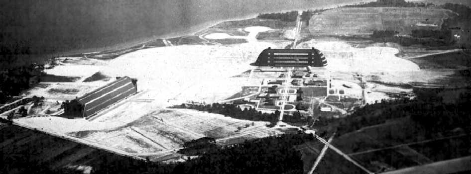
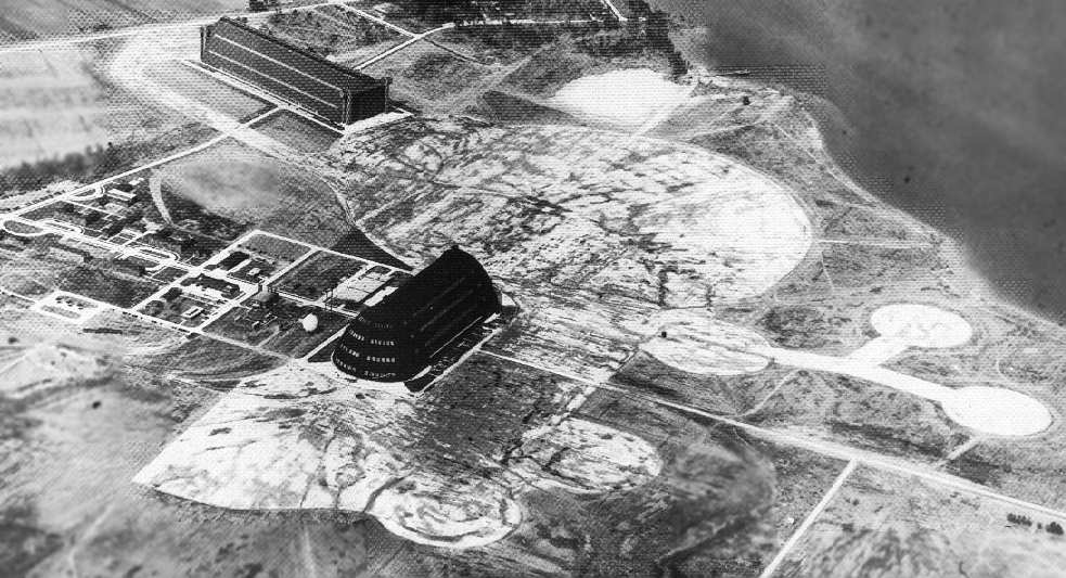
A 1943 aerial view looking east at Weeksville (courtesy of Mark Hess), showing the 2 massive blimp hangars.
The 1940 USGS topo map depicted an “Air Base” at this location.
However, Weeksville was reportedly built in 1941 on a 765 acre site as a Navy antisubmarine blimp base
(similar to Tustin CA & Moffet Field CA).
No airfield was yet depicted at Weeksville on the August 1942 14M Regional Aeronautical Chart (courtesy of Chris Kennedy).
Weeksville's Hangar 1 was built by J. A. Jones Construction in 1942.
The material used for the roofing was corrugated metal.
When it was commissioned in 1942,
Weeksville was only the second Navy blimp base on the east coast,
Lakehurst NAS being the only other.
The first antisubmarine blimp patrol from Weeksville was conducted in 1942 by squadron ZP-14.
Operations were usually conducted with 8 K-ship blimps.
At times a single blimp was detached to Patuxent River NAS.
The earliest photo of the Weeksville airfield which has been located
was a 1943 aerial view looking east (courtesy of Mark Hess),.
It depicted the field as having 2 massive blimp hangars,
with multiple circular blimp mooring pads extending out from the large central paved circle.
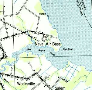
The 1943 USGS topo map depicted a “Naval Air Base” at Weeksville.
The earliest aeronautical chart depiction of the Weeksville airfield which has been located
was on the September 1943 Norfolk Sectional Chart (courtesy of Chris Kennedy).
A 2/16/44 aerial view looking north at Weeksville from the 1945 AAF Airfield Directory (courtesy of Scott Murdock),
showing the 2 blimp hangars, large central blimp mooring pad, and 5 smaller blimp mooring circles.
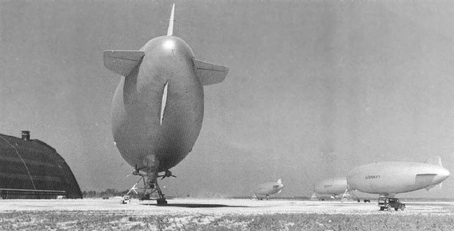
Four K-class airships moored at Weeksville during WW2.
An undated photo of a Navy blimp inside a Weeksville hangar.
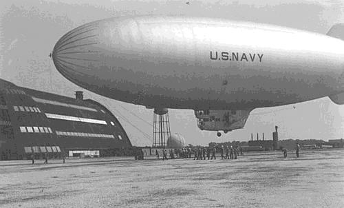
A navy blimp being moored, 1944.
A Navy blimp being pulled out of Hangar 2.
During Weeksville's WW2 heyday, the facility consisted of 2 huge blimp hangars,
wooden Airdock #2 (900' long, NW side of base)
& steel Airdock #1 (1,058' long, S side of base, 300' wide, 200' high, with 2 massive clamshell doors at both ends of the hangar).
Each hangar was capable of housing 6 blimps simultaneously!
The hangars sat adjoining a 2,000' diameter blimp mooring pad,
which also had 6 smaller blimp mooring circles.
A 3,700' runway extended across the blimp mat,
and was used for aircraft weighing less than 5,000 pounds.
Weeksville also had a seaplane ramp which led into the adjacent Pasquatauk River.
This was used as a transit facility for seaplanes,
primarily PBY Catalinas going to Britain.
In 1944 the station had a total of 886 officers & enlisted personnel.
"Weeksville (Navy)", as depicted on the April 1945 Norfolk Sectional Chart (courtesy of Chris Kennedy).
The 1945 AAF Airfield Directory (courtesy of Scott Murdock) described Weeksville NAS
as a 760 acre irregularly-shaped property having a 2,000' diameter circular asphalt landing mat,
with a 1,200' x 1,000' asphalt irregular landing mat,
with the maximum distance available being 3,700' north/south.
The field was said to have a 1,000' x 237' wooden hangar & a 850' x 300' steel hangar,
to be owned by the U.S. Government, and to operated by the Navy.
With the end of WW2, Weeksville was reduced to a Naval Auxiliary Air Station in 1945.
From 1945-1948, it was used for storage of surplus fixed-wing aircraft,
eventually housing a maximum of 576 aircraft in 1946.
The last Navy blimp departed Weeksville in 1946.
Aerial view of Weeksville, 1953, looking NE. Hangar 2 is on left, Hangar 1 is on right.
In 1947, however, it became an operational blimp base again, with the arrival of 4 blimps.
During the Korean War, Weeksville was used for extensive ASW blimp operations,
hosting a fixed-wing Carrier Air Group, and hosting ASW helicopter squadrons.
Nick England recalled, "I lived in Elizabeth City as a kid from 1955-65
and had lots of buddies whose fathers were in the Navy at Weeksville NAS.
I remember playing marbles one time when this big shadow came over us -
a blimp had come overhead without us noticing!"
Richard Legg recalled, “I was stationed with ZP-1 at NAF Weeksville from September 1955 until the stationed closed in 1957.”
A 1956 aerial view looking west at Weeksville.
Weeksville was disestablished by the military in 1957 & and sold to private interests.
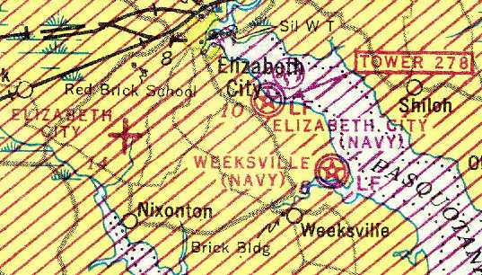
The Weeksville airfield was labeled "Elizabeth City (Navy)" on the May 1960 Chesapeake Bay World Aeronautical Chart (courtesy of Scott Kimball).
The airfield was described as having a 3,200' paved runway, but the airfield status was listed as "Closed".
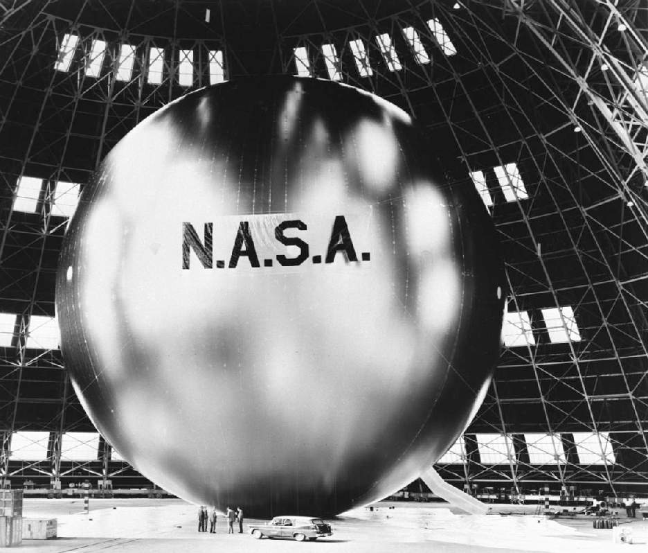
A 1961 photo of the NASA Echo satellite being inflated inside the Weeksville hangar.
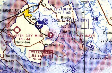
The Weeksville airfield was labeled "Elizabeth City (Navy)" on the 1965 Norfolk Sectional Chart (courtesy of John Voss).
The Aerodromes table described the airfield as consisting of 2 asphalt runways,
with the longest being 3,200'.
The airfield status was listed as "Closed".
In 1966, the decommissioned Weeksville facility was sold to Westinghouse, for use in their blimp operations.
However the Weeksville airfield continued to be depicted as “Elizabeth City (Navy)” on the 1969 USGS topo map.
The 1987 USGS topo map did not label the Weeksville facility at all,
but it depicted the 2 blimp hangars, other buildings, and railroad lines.
The outline of several of the smaller blimp mooring pads were depicted, but not the 2 runways.
In 1989 Westinghouse transferred its blimp operations to TCOM,
which subsequently built commercial airships at Weeksville which have operated as "Bud One", "Fuji", and "Met Life".
USGS photo 1993, before Hangar 2 burned down.
Note the seaplane ramp at the northeast corner,
the circular blimp mooring circle in the grass at right-center,
and the circular blimp mooring circles at the bottom of the photo.
Remnants of the 2 runways were also still recognizable.
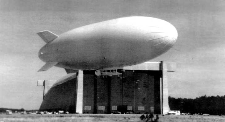
The last photo which has been located showing Weeksville's wooden Hangar #2 still intact was a circa 1994-95 view of the Airship Industries Sentinel 1000.
The Sentinel 1000 was at the time the world's largest airship – measuring 222' in length, with a gas volume of 353,146 cubic feet.
It was developed by Airship Industries as an intermediate-sized ship
for gaining experience for their planned Sentinel 5000 airship (which never ended up being built).
The Sentinel 1000's gondola was borrowed from an existing Skyship 600,
along with the powerplant of twin Porsche 300 hp engines.
The tailfin arrangement was changed to an "X" configuration (which had been used previously in airships in the 1950s & 60s),
which enabled the larger airship to have ample clearance on takeoff when the ship is pitched up.
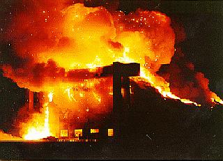
TCOM's use of the Weeksville facility was marred on 8/3/95,
when the wooden Airdock #2 burned down in a spectacular fire,
during reconstruction of the hangar door supports.
Inside the hangar were 2 Airship Industries Skyship blimps & the sole prototype of the Sentinel 1000 (the world's largest airship at the time).
All 3 blimps were destroyed,
effectively putting an end to the Sentinel 1000 program.
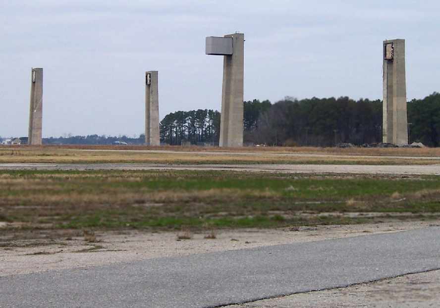
A 1995-99 aerial view looking north at the remains of Airdock #2,
Note the massive steel latticework which remained after the fire, but was eventually removed.
TCOM purchased Weeksville's steel Hangar 1 from Triangle Pacific in 1996.
An 8/99 aerial photo looking northwest, taken by Paul Freeman from a Diamond Katana DA20C-1.
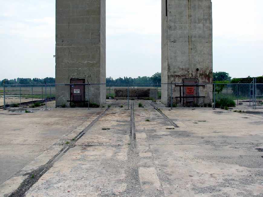
Note concrete towers at top left, all that remains of wooden Hangar 2.
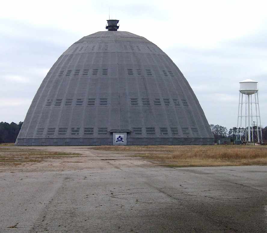
The steel-construction Airdock #1 remains standing.
Remains are still visible of huge circular blimp mooring field,
two runways (13/31 & 2/20), numerous circular blimp mooring positions
& a seaplane launching ramp at Northeast corner of field.
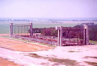
A beautiful 2002 picture by Brian Hawley of the interior of the clamshell doors of the Weeksville blimp hangar.
For a sense of scale, note the man in front of the door at the bottom-center.

A 2002 photo by Brian Hawley of the rail-mounted motors which open the massive doors of the Weeksville blimp hangar.
Brian reported he “was lucky enough to get a guided tour of the facility.
It was amazing. The inside of the steel hangar was spectacular.
The doors were massive.
They used so much power according to our guide that back before they were powered on-site with generators
only one could be opened at a time."
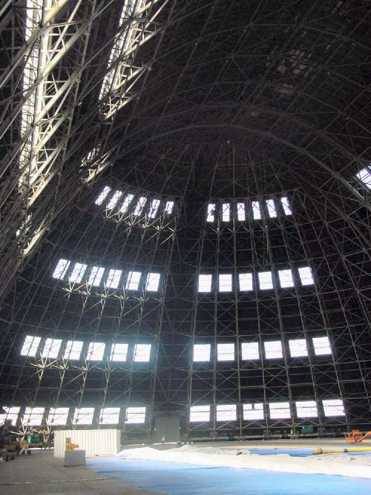
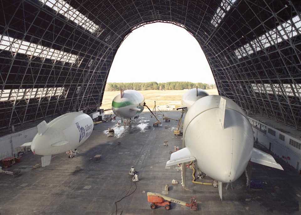
A 2002 photo by Brian Hawley of the the interior of the Weeksville blimp hangar shows the huge size of the building to good effect:
Note how the tractor trailer appears to be the size of a toy.
The blimp in the background operated as the Spirit of Atlanta during the 1996 Olympic Games.
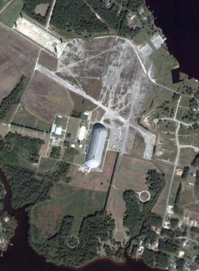
A 2006 aerial view shows that a new street had been built at some point between 1999-2006 on the east side of the former airfield,
but the majority of the Weeksville airfield remained the same.
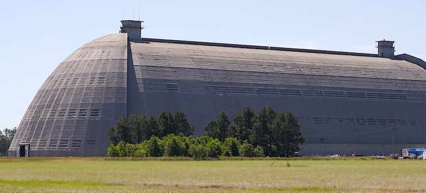
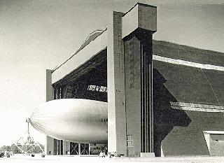
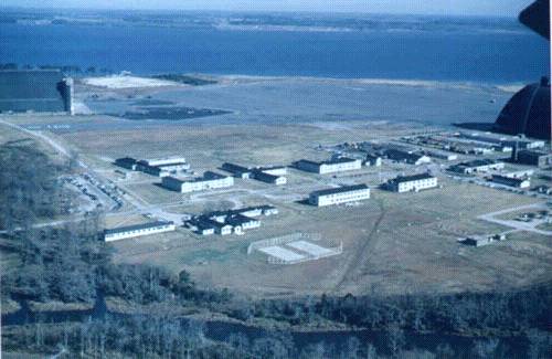
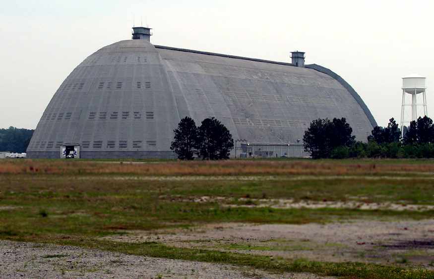
A June 1, 2007 photo by Robert Lee, looking east at the remaining Weeksville blimp hangar, Airdock #1.
Note what appear to be control tower cabs on top of both ends of the hangar.
A January 2008 photo by Lawrence Schmitz looking south at the remaining Weeksville blimp hangar, Airdock #1.
Lawrence Schmitz reported, “I visited the Weeksville blimp base today, January 12, 2008.
The remaining hangar is still there in good condition,
and looks to have been coated with weather-proofing sometime in the last 10 years.
The [south] doors are sealed, but the [north] doors look to be still functional.
The whole area has grown up with weeds & there seems to be a lot of support equipment through the whole area.”
A January 2008 photo by Lawrence Schmitz looking northwest at the remains of Weeksville blimp hangar Airdock #2.
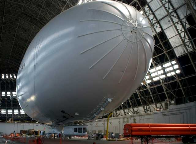
An undated photo of a TCOM aerostat & another envelope being inflated inside Weeksville's Hangar 1.
An undated photo of a 4 blimps inside Weeksville's Hangar 1.
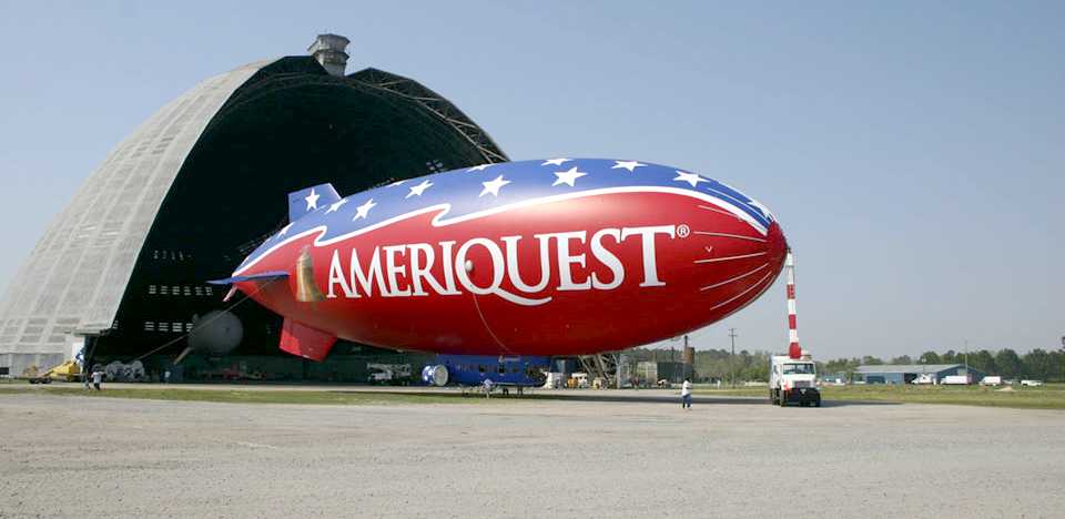
An undated photo looking south at an Ameriquest blimp moored outside of Weeksville's Hangar 1.
In 2008 TCOM completed construction on a new "Ground Systems Manufacturing & Test Facility" on its 100 acre Weeksville site
to significantly expand their mooring system production capability.
This new facility will enable TCOM to build much larger mooring systems to accommodate aerostats over 100 meters in length.
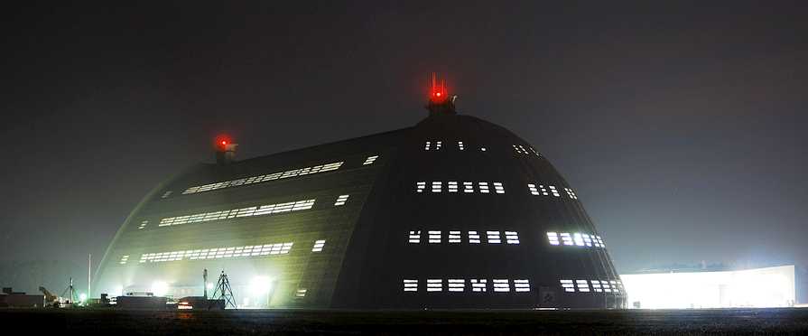
An 11/26/09 night view looking southwest at Weeksville's Hangar 1.
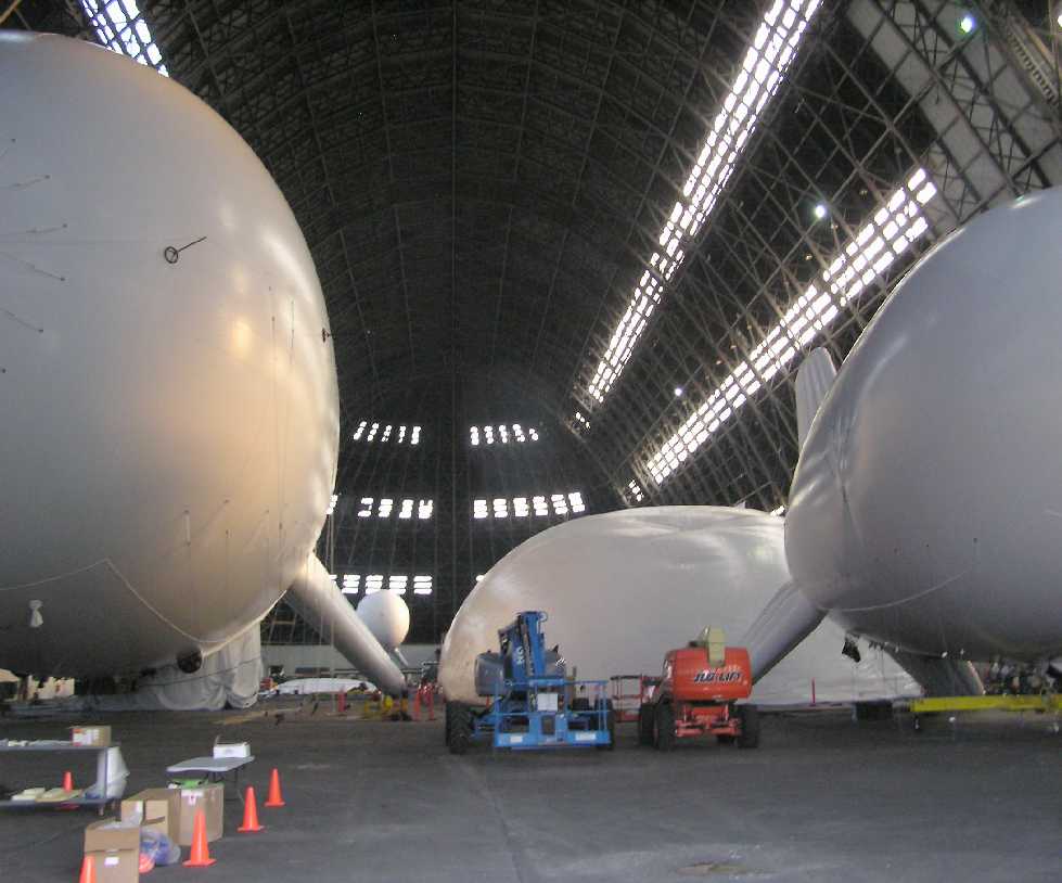
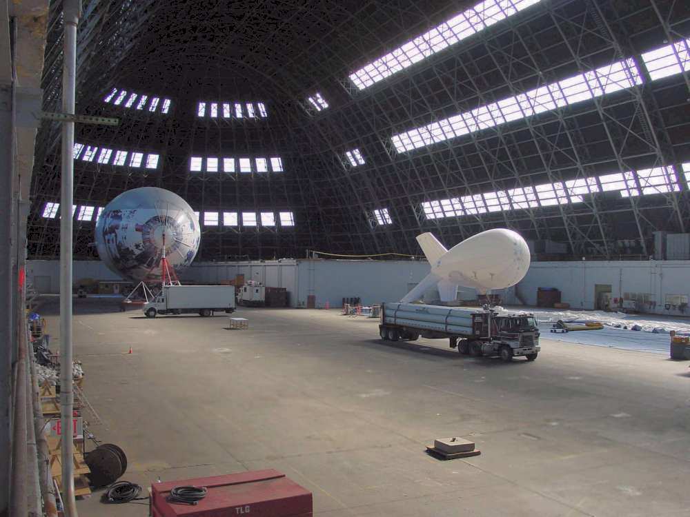
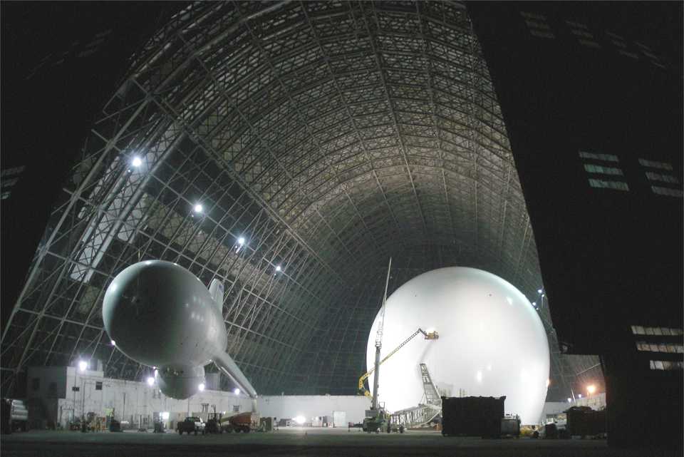
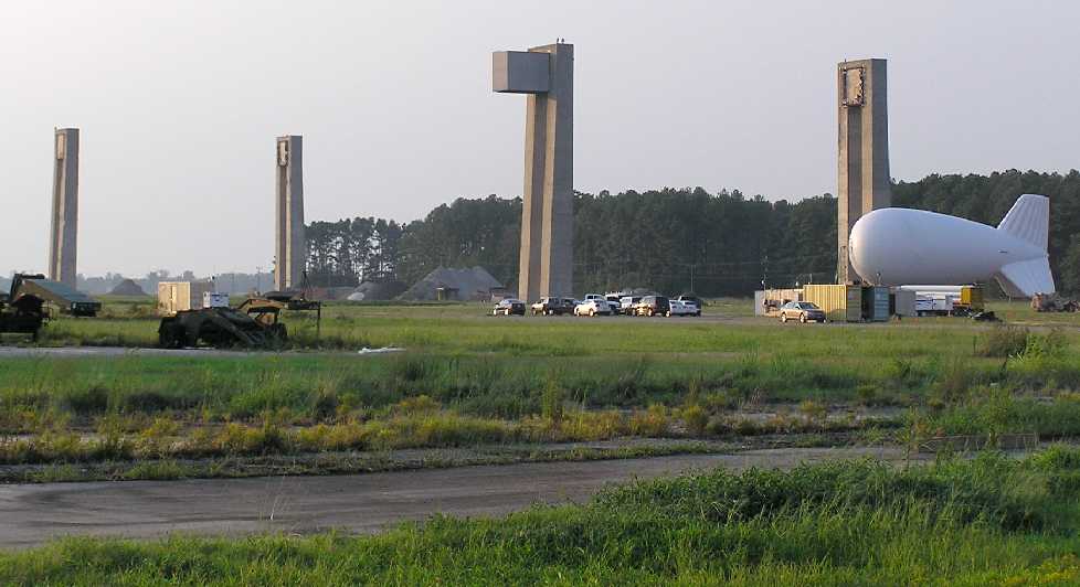
An October 2011 photo by William Kempf of 4 or 5 aerostats in the process of being inflated inside Weeksville's Hangar 1.
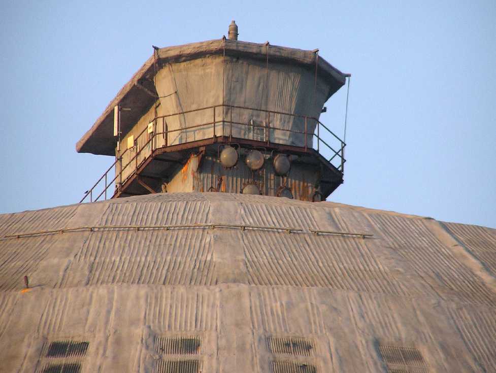
An October 2011 photo by William Kempf of one of the control towers which sits atop Weeksville's Hangar 1,
of which all of the windows had been blocked off.
William observed, “Look at each of control towers - even the clearance lights were painted - I guess because of the USCG airbase next door?
I bet those towers had unbelievable views.”
An October 2011 photo by William Kempf of an aerostat next to the remains of Weeksville blimp hangar Airdock #2.
A 2012 photo by Alan Ram of the prototype Mav6 Blue Devil surveillance airship under construction inside the Weeksville blimp hangar.
If completed, the Blue Devil would be the world's longest aircraft currently in existence.
Alan reported, “All that's really missing of note is the landing gear & tailfins.”
____________________________________________________
Elizabeth City Municipal Airport (1st location), Elizabeth City, NC
36.26, -76.19 (Southwest of Norfolk, VA)
The original location of the Elizabeth City Municipal Airport, as depicted on a 1935 Regional Aeronautical Chart.
Photo of the airport while open has not been located.
The original location of the Elizabeth City Municipal Airport was southeast of the town,
on the opposite side of the road from the eventual location of the present-day Elizabeth City CGAS / Municipal Airport.
The date of construction of the original Elizabeth City Municipal Airport is unknown.
It was apparently built prior to 1935, as it was depicted in its original location on the 1935 Regional Aeronautical Chart.
Elizabeth City Airport was described in The Airport Directory Company's 1937 Airports Directory (courtesy of Bob Rambo)
as being located 2.5 miles southeast of the town, on the west side of the Weeksville Highway.
It was described as having 2 landing strips in an "L" shape,
with the longest being 2,700' northeast/southwest strip.
The original location of the Elizabeth City Municipal Airport,
as depicted on the July 1941 Norfolk Sectional Chart (courtesy of Chris Kennedy).
Elizabeth City Municipal Airport was still depicted in its original location
on the August 1942 14M Regional Aeronautical Chart (according to Chris Kennedy).
However, at some point between 1942-43,
Elizabeth City Airport apparently was relocated a few miles west to its second location (southwest of the town of Elizabeth City),
as that is where it was depicted on the September 1943 Norfolk Sectional Chart (courtesy of Chris Kennedy).
The relocation of the civilian airport was most likely due to wartime security concerns,
as well as the increased traffic at the Elizabeth City CGAS on the opposite side of the road.
Nothing was depicted at the site of the Elizabeth City Airport on the 1948 USGS topo map.
Not a trace of the original Elizabeth City Airport appeared to remain recognizable on a 1952 USGS aerial photo,
with the area having been returned to cultivation.
As seen in a 2006 aerial photo, not a trace of the original Elizabeth City Airport remains perceptible.
Note the present-day Elizabeth City Coast Guard Air Station / Municipal Airport across the road to the northeast.
The site of the first location of the Elizabeth City Municipal Airport is located
south of the intersection of Route 34 & Pitts Chapel Road,
just across Route 34 from the present-day Elizabeth City Coast Guard Air Station / Municipal Airport.
____________________________________________________
Elizabeth City Municipal Airport (2nd location), Elizabeth City, NC
36.25, -76.26 (Southwest of Norfolk, VA)
The 2nd location of the Elizabeth City Municipal Airport,
as depicted on the September 1943 Norfolk Sectional Chart (courtesy of Chris Kennedy).
At some point between 1942-43,
the Elizabeth City Airport apparently was relocated southwest of the town, from its original location.
The earliest depiction of the field at this location which has been located
was on the September 1943 Norfolk Sectional Chart (courtesy of Chris Kennedy).
The April 1944 US Army/Navy Directory of Airfields (courtesy of Ken Mercer)
described Elizabeth City Airport as having a 3,800' unpaved runway.
The earliest photo which has been located of the 2nd location of Elizabeth City Airport was a 3/6/52 USGS aerial view.
It depicted Elizabeth City as having 3 grass runways, with a hangar & 5 single-engine aircraft on the east side.
From 1957-68, a Air Force Gap Filler Air Defense Radar installation (P-56C / M-117B)
was operational on the property of the Elizabeth City Municipal Airport (thanks to Thomas Page for pointing this out).
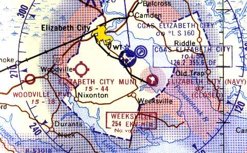
Elizabeth City was described on the May 1960 Chesapeake Bay World Aeronautical Chart (courtesy of Scott Kimball)
as having a 2,800' runway.
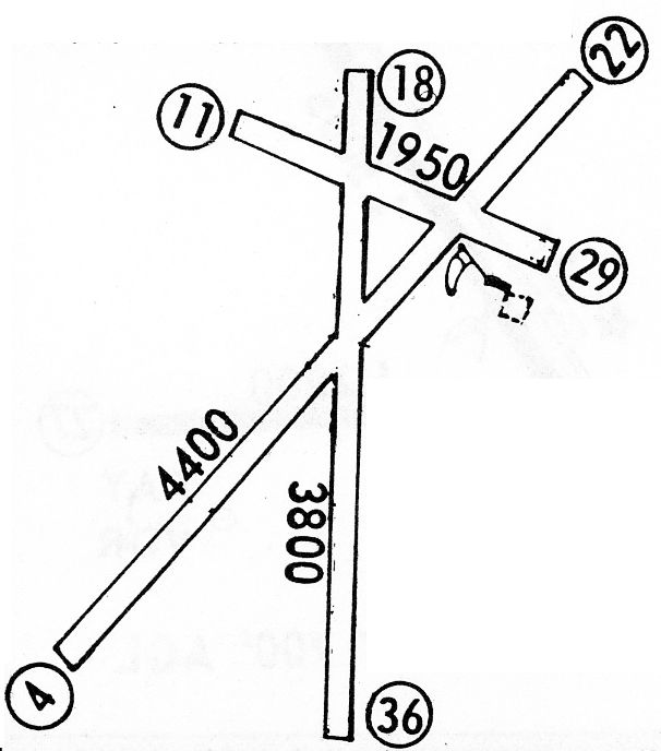
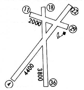
The 1962 AOPA Airport Directory described Elizabeth City Municipal Airport
as having three 4,000' turf runways: 18/36, 4/22 & 14/32.
The operator was listed as Coastal Aviation, Inc.
The Aerodromes table on the 1965 Norfolk Sectional Chart (courtesy of John Voss)
described the airfield as consisting of 3 turf runways, with the longest being 4,400'.
The 1968 Flight Guide (courtesy of Bob Levittan)
depicted Elizabeth City Municipal as having 3 unpaved runways,
with the longest being the 4,400' Runway 4/22.
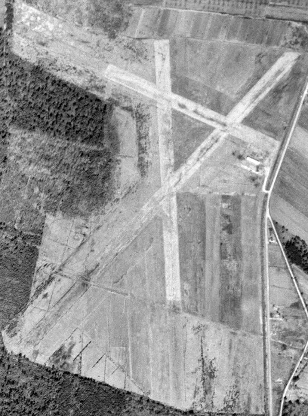
The last photo which has been located showing the 2nd location of Elizabeth City Airport while in operation
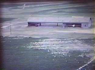
was a circa 1968 photo (courtesy of Thomas Page) showing 2 planes inside a hangar.
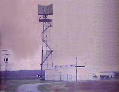
A circa 1968 photo of the Air Force gap-filler radar installation adjacent to the Elizabeth City Airport (courtesy of Thomas Page).
A 1971 airfield directory (courtesy of Chris Kennedy)
depicted Elizabeth City Municipal as having 3 unpaved runways,
with the longest being the 4,400' Runway 4/22.
Elizabeth City Municipal Airport was still depicted on the 1973 Washington Sectional Chart (courtesy of Mike Keefe),
and described as having a 4,400' unpaved runway.
The Elizabeth City Municipal Airport was apparently closed at this location at some point between 1973-75,
as no airfield was depicted here on the 1975 Washington Sectional Chart (courtesy of Ed Drury).
The much larger Elizabeth City Coast Guard Air Station (a few miles to the east)
opened itself up to civilian operations,
and the new Elizabeth City Municipal Airport was established along the south side of the Coast Guard airfield.
The clearings of the former runways were still depicted on the 1982 USGS topo map, but not the airport itself.
The former Elizabeth City Municipal Airport was not depicted at on the 1985 & 1987 USGS topo maps.
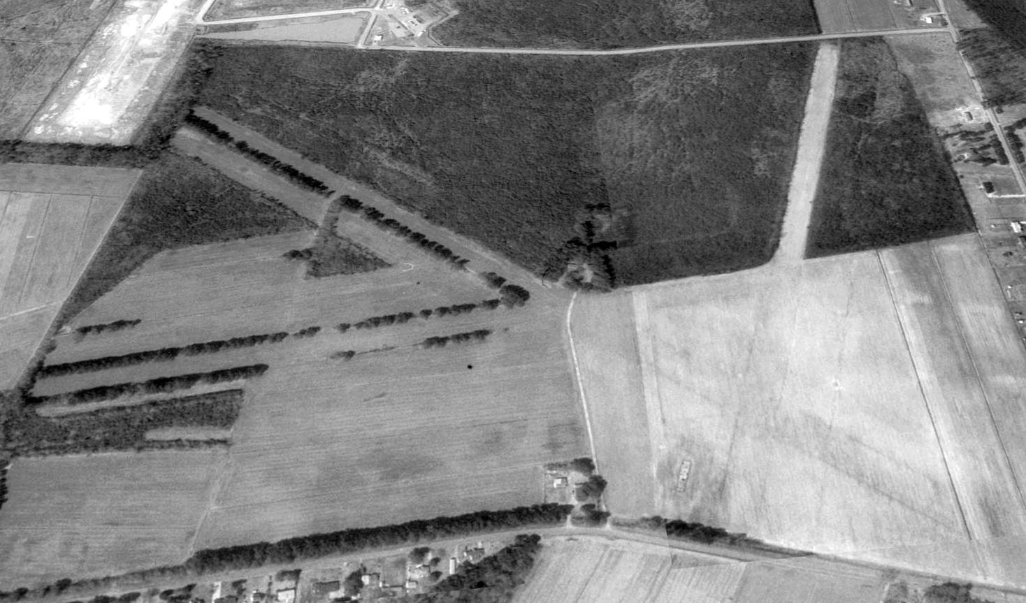
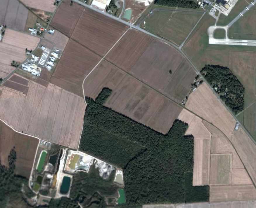
A 1993 USGS aerial view looking west at the 2nd location of Elizabeth City Municipal Airport showed the outline of the 3 former runways was still clearly recognizable.
No former airfield buildings appeared to remain standing.
However, one building from the former Air Force Gap Filler Air Defense Radar installation was still visible, southeast of the runway intersection, on the west side of the road.
A 1998 aerial photo showed one street for a new housing development had been built on the northern end of the airport site.
A 2005 aerial photo showed a housing development had covered the 2nd location of Elizabeth City Municipal Airport,
but the alignment of Runway 4/22 was still plainly evident, and the northwestern end of Runway 11/29 remained intact.
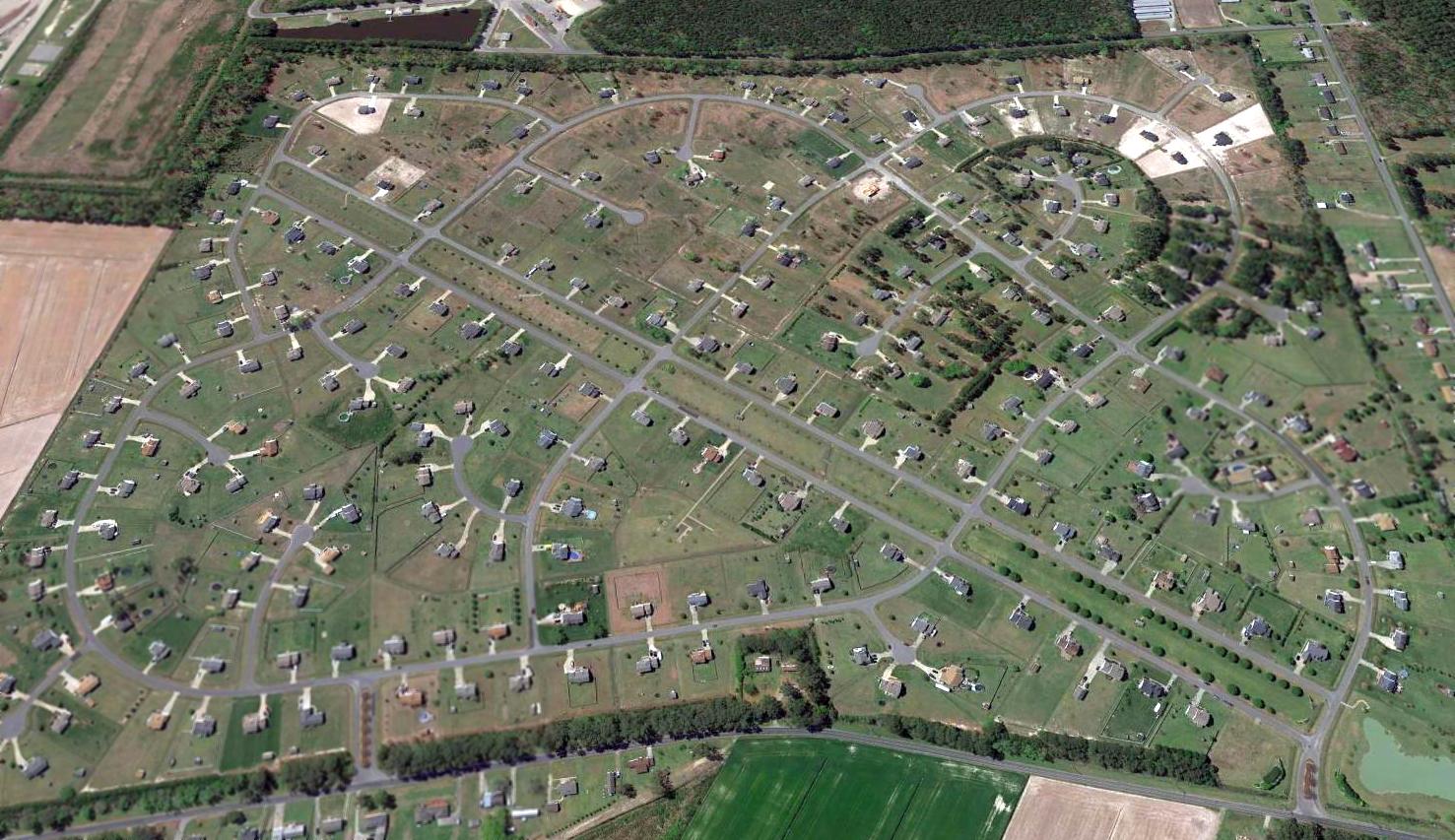
A 2016 aerial view looking west at the 2nd location of Elizabeth City Municipal Airport showed the site covered by a housing development.
But the alignment of Runway 4/22 was still plainly evident, reused as Queenswood Boulevard & Kingswood Boulevard.
The site of the 2nd location of Elizabeth City Municipal Airport is located southwest of the intersection of Body Road & Simpson Ditch Road.
____________________________________________________
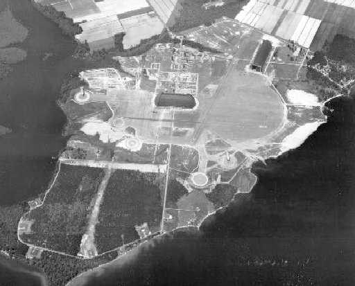
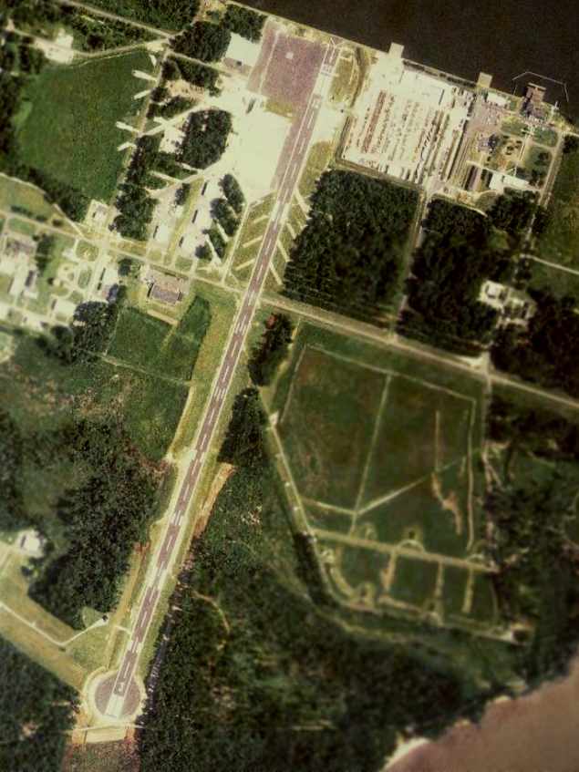
Harvey Point Naval Auxiliary Air Station, Harvey Point, NC
36.1 North / 76.33 West (South of Elizabeth City, NC)
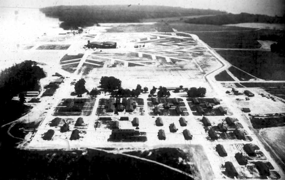
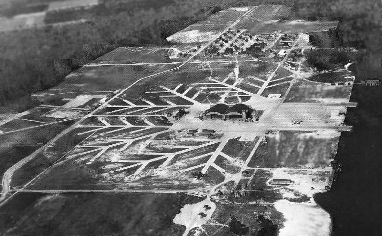
A circa 1942-43 aerial view looking east at Harvey Point NAAS (courtesy of Mark Hess).
Harvey Point was built in 1942 as a Navy seaplane training base.
No aviation facility was yet depicted at Harvey Point on the 1942 USGS topo map
nor the August 1942 14M Regional Aeronautical Chart (courtesy of Chris Kennedy).
The earliest depiction of the Harvey Point base which has been located
was a circa 1942-43 aerial view looking east at Harvey Point NAAS (courtesy of Mark Hess).
It depicted the seaplane base as having 2 large hangars with a tower in the center,
a concrete apron, and an amazing number of concrete seaplane parking revetments extending out from the hangars in a "tree" arrangement.
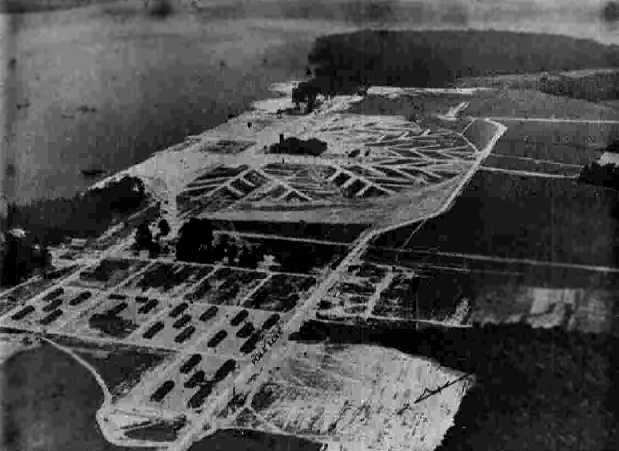
A 7/26/43 aerial view looking southeast at Harvey Point NAAS from the 1945 AAF Airfield Directory (courtesy of Scott Murdock).
The earliest aeronautical chart depiction of the Harvey Point base which has been located
was on the September 1943 Norfolk Sectional Chart (courtesy of Chris Kennedy).
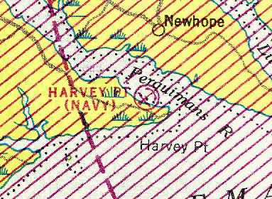
It depicted "Harvey Pt (Navy)" as a seaplane base.
PBM squadron VPB-215 was commissioned at Harvey Point in late 1943,
and patrol squadron VPB-27 was commissioned there in June 1944.
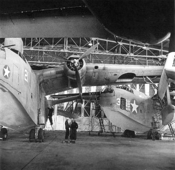
Three Martin PBM Marlin seaplanes inside a Harvey Point hangar during WW2 (National Archives photo).
Harvey Point NAAS reached its peak complement in 1944, housing over 1,900 men.
A WW2-era aerial view looking west at the Harvey Point seaplane base (National Archives photo),
showing at least 2 aircraft parked on the field.
During WW2, Harvey Point did not have any runways,
as its aviation facilities were strictly intended to support seaplanes.

"Harvey Pt (Navy)" was depicted as a seaplane base with a control tower
on the April 1945 Norfolk Sectional Chart (courtesy of Chris Kennedy).
The 1945 AAF Airfield Directory (courtesy of Scott Murdock) described Harvey Point NAAS
as having two 194' x 100' wooden hangars,
to be owned by the U.S. Government, and to operated by the Navy.
Harvey Point NAAS was disestablished by the Navy in 1946.
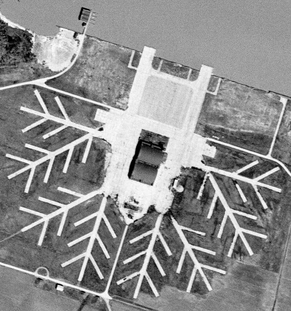
A 3/20/52 USGS aerial photo depicted the abandoned Harvey Point base as having 2 large hangars in the center,
a concrete apron, and an amazing number of concrete seaplane parking revetments extending out from the hangars in a "tree" arrangement.
Note there was not yet any runway for land aircraft.
In 1958, the Navy chose the abandoned Harvey Point site
to serve as the location for a dedicated base for the new P6M Seamaster jet seaplane.
Construction began at Harvey Point to create support facilities for the new seaplane.
At that point, employment on the base totaled approximately 2,700 military & civilian workers.
No airfield at Harvey Point was depicted on the May 1960 Chesapeake Bay World Aeronautical Chart (courtesy of Scott Kimball).
In 1963, the abrupt cancellation of the Seamaster aircraft caused Harvey Point
to be once again "disestablished" - but is highly probable that this rapid buildup & "disestablishment"
may have been a cover story to conceal the CIA's takeover of the base.
On the 1965 Norfolk Sectional Chart (courtesy of John Voss)
and the 1972 Washington Sectional Chart (courtesy of Mike Keefe),
no aviation facility was depicted at the site, only "buildings".
Harvey Point eventually became one of the CIA's 2 field operative training sites (the other is at Camp Peary, VA).
Harvey Point is used by CIA's Directorate of Operations for personnel training in explosives,
paramilitary combat, and other clandestine warfare techniques.
The Point is where "hardcore" paramilitary ops are worked on.
When the facility was taken over by the CIA, the 2 hangars were removed,
and a paved 5,000' runway was constructed over the area formerly occupied
by the hangars & the eastern parking revetments.
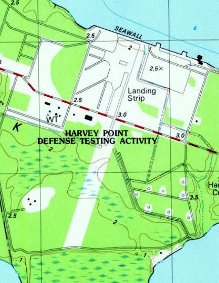
On the 1982 USGS topo map, a single runway was depicted, labeled as “Landing Strip”,
and the property was labeled as the “Harvey Point Defense Testing Activity”.
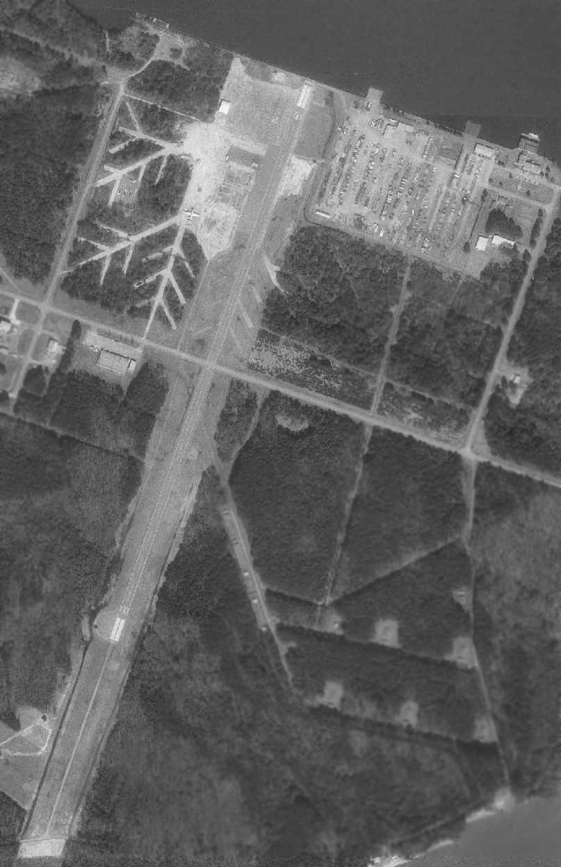
In the 1993 USGS aerial photo, the paved 5,000' runway was clearly evident,
as well as the WW2-era parking revetments west of the runway.
Note the 4-engined transport (DC-7?) parked along the west side of the runway.
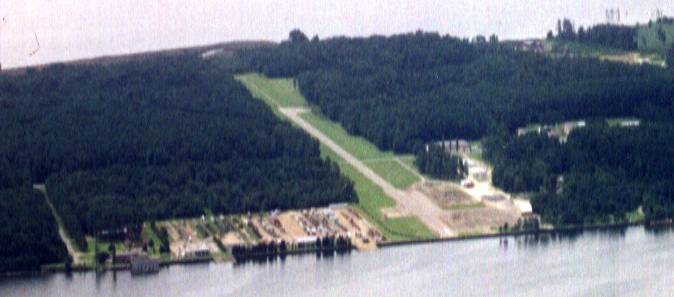
An 8/99 aerial photo looking southwest, taken by Paul Freeman from a Diamond Katana DA20C-1.
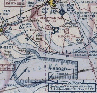
As seen on a recent Washington Sectional Chart,
the airspace over this facility is covered by a Restricted Area (R-5301).
Note that there is a mention of "buildings" on the chart, but no depiction at all of a runway.
This is very unusual for a sectional chart, as military airfields are always depicted
(even the CIA's field at Camp Peary, VA, which is clearly depicted & labeled).
The Sectional Chart shows that clearance to pass through R-5301
must be obtained by contacting "GIANT KILLER" - sounds serious, huh?
A 2006 aerial view shows the single paved Runway 3/21 to have been recently painted.
The large 4-engine aircraft visible on the west side of the runway in the 1993 photo was no longer visible.
See also: http://www.ufomind.com/misc/1998/apr/d01-004.shtml
____________________________________________________
Since this site was first put on the web in 1999, its popularity has grown tremendously.
That has caused it to often exceed bandwidth limitations
set by the company which I pay to host it on the web.
If the total quantity of material on this site is to continue to grow,
it will require ever-increasing funding to pay its expenses.
Therefore, I request financial contributions from site visitors,
to help defray the increasing costs of the site
and ensure that it continues to be available & to grow.
What would you pay for a good aviation magazine, or a good aviation book?
Please consider a donation of an equivalent amount, at the least.
This site is not supported by commercial advertising –
it is purely supported by donations.
If you enjoy the site, and would like to make a financial contribution,
you
may use a credit card via
![]() ,
using one of 2 methods:
,
using one of 2 methods:
To make a one-time donation of an amount of your choice:
Or you can sign up for a $10 monthly subscription to help support the site on an ongoing basis:
Or if you prefer to contact me directly concerning a contribution (for a mailing address to send a check),
please contact me at: paulandterryfreeman@gmail.com
If you enjoy this web site, please support it with a financial contribution.
please contact me at: paulandterryfreeman@gmail.com
If you enjoy this web site, please support it with a financial contribution.
____________________________________________________
This site covers airfields in all 50 states.