Abandoned & Little-Known Airfields:
North Carolina: Charlotte area
© 2002, © 2015 by Paul Freeman. Revised 7/10/16.
This site covers airfields in all 50 states: Click here for the site's main menu.
____________________________________________________
Please consider a financial contribution to support the continued growth & operation of this site.
Albemarle Airport (revised 6/30/15) - Brockenbrough Airport (revised 6/30/15) - Carolina Air Park / Carolina Skypark (revised 7/10/16)
Carpenter Airfield (revised 6/30/15) - (Original) Charlotte Airport / Cannon Airport (added 1/4/14) - Concord Airport (original location) (added 5/18/16)
Delta Air Base (revised 2/15/14) - Lincoln Airport (revised 6/30/15) - Plaza Airport (revised 6/11/16)
North Wilkesboro Airport (revised 4/24/16) - (Original) Wilkes County Airport (revised 6/30/15)
____________________________________________________
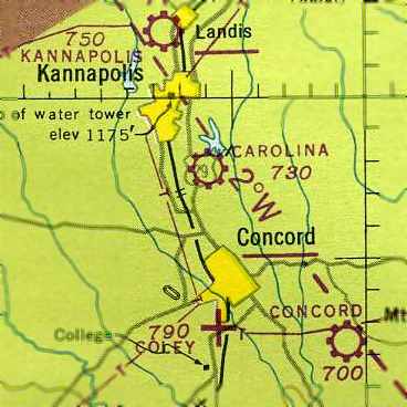
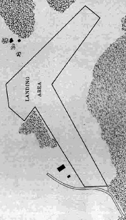
Concord Airport (original location), Concord, NC
35.385, -80.492 (Northeast of Charlotte, NC)
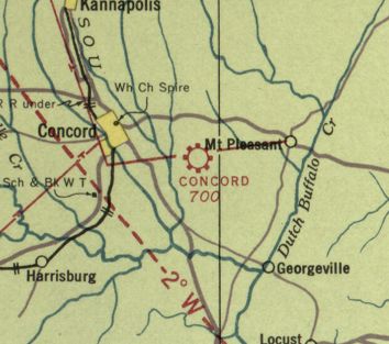
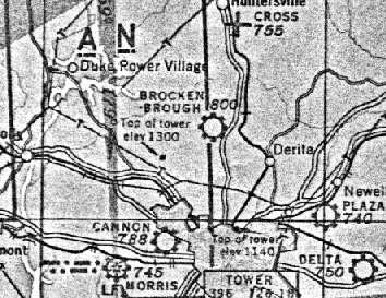
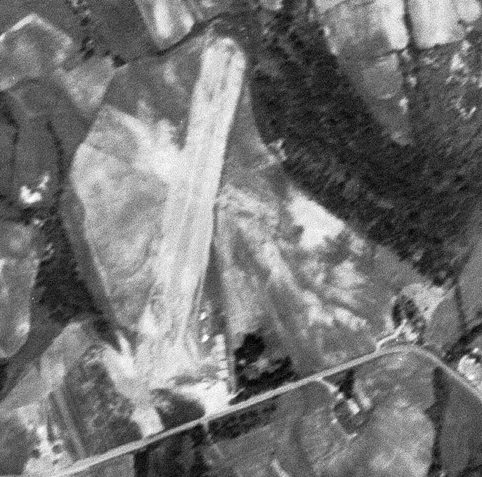
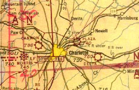
The original Concord Airport, as depicted on the October 1940 Charlotte Sectional Chart.
The original airport for the town of Concord was located southeast of the town.
It was evidently established at some point between 1935-40,
as it was not yet depicted on the May 1935 Charlotte Sectional Chart.
The earliest depiction which has been located of Concord Airport
was on the October 1940 Charlotte Sectional Chart, which depicted Concord as a commercial/municipal airport.
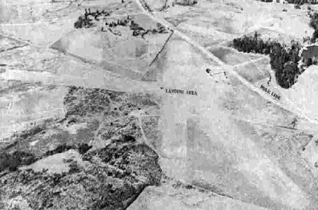
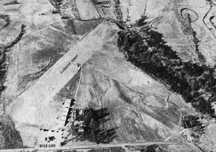
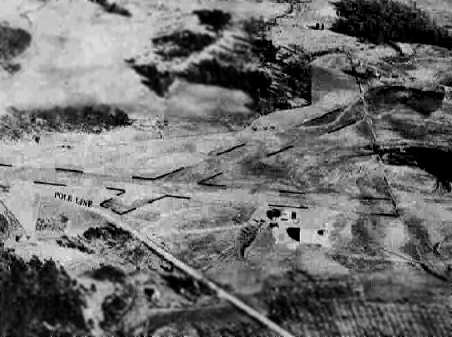
The only photo which has been located of the original Concord Airport
was a circa 1943-45 aerial view looking north from the 1945 AAF Airfield Directory (courtesy of Scott Murdock).
It depicted Concord Aiport as having 2 (or 3) unpaved runways, with a small building on the east side.
The 1945 AAF Airfield Directory (courtesy of Scott Murdock) described Concord Airport
as a 100 acre cross-shaped property having 2 clay runways, measuring 1,920' northwest/southeast & 1,800' northeast/southwest.
The field was said to have 3 hangars, the largest being a 80' x 44' wood & metal structure.
Concord Airport was described as being owned & operated by private interests.
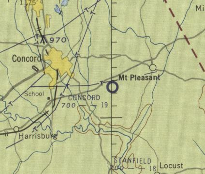
The original Concord Airport, as depicted on the 1954 USGS topo map.
According to Clark Howard, “The old Concord Airport had 2 dirt runways, along with 2 hangars, which housed several light aircraft.
One of these buildings hosted the Civil Air Patrol for some years. It was located several miles southeast of town.
The airport was used on weekends for airplane rides, skydiving, and model airplane meets.
I was treated to my first airplane ride there in 1954, in a Piper Super Cruiser.
During the 1950s, there were several BT-13 aircraft parked derelict along with a large Stinson V77.
These aircraft & the hangars were removed shortly before the airport was closed.”
The last aeronautical chart depiction which has been located of Concord Airport was on the January 1955 Charlotte Sectional Chart.
It depicted Concord Airport as having a 1,900' unpaved runway.
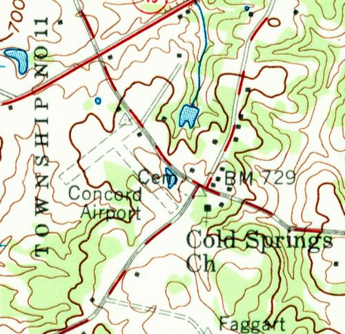
The 1957 USGS topo map depicted Concord Airport as having 2 perpendicular unpaved runways, with 2 small buildings on the northeast side.
A 1965 aerial view showed the original Concord Airport remained intact, including the 2 grass runways & the 2 buildings on the northeast side,
but there were no aircraft visible on the field nor any other indication of recent aviation use.
The 1974 USGS topo map depicted the original Concord Airport in the same fashion as the 1957 topo map.
The original Concord Airport was evidently closed by 1980,
as the 1980 USGS topo map depicted an empty area in place of the airport.

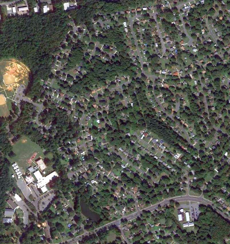
A 2015 aerial view looking north showed no trace of the original Concord Airport.
The site of the original Concord Airport is subtly acknowledged in the names of the residential streets which covered the airport:
Boyington Court & Navion Place.
Thanks to Clark Howard for pointing out this airfield.
____________________________________________________
35.26, -80.76 (Northwest of Downtown Charlotte, NC)
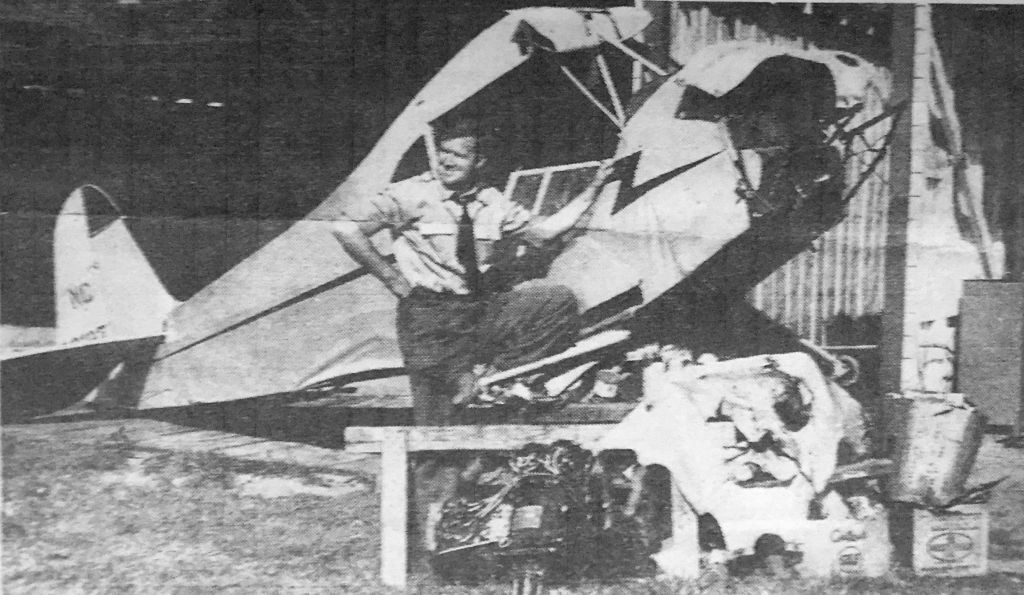
A circa 1942-43 photo of Haskell Deaton of the Plaza Airport in front of a Piper Cub has we donating to a Civil Air Patrol scrap metal campaign (courtesy of David Stevenson).
According to Eric Karnes, “Plaza Airport... was operated by Johnny Crowell, a pioneer NC aviator.
It may have been established in the 1920s.”
The earliest depiction which has been located of Plaza Airport
was a circa 1942-43 photo of Haskell Deaton of the Plaza Airport in front of a Piper Cub has we donating to a Civil Air Patrol scrap metal campaign (courtesy of David Stevenson).
The earliest aerial view which has been located of Plaza Airport
was a circa 1943-45 aerial view looking north from the 1945 AAF Airfield Directory (courtesy of Scott Murdock).
It depicted Plaza Airport as having 2 unpaved runways, with a row of hangars on the south side.
The 1945 AAF Airfield Directory (courtesy of Scott Murdock) described Plaza Airport
as a 28 acre cross-shaped property having clay runways, measuring 2,000' north-northeast/south-southwest & 1,400' west-northwest/east-southeast (“badly eroded”).
The field was said to have 7 wooden hangars, each measuring 40' sqare.,
and was described as being owned & operated by private interests.
The earliest aeronautical chart depiction which has been located of Plaza Airport
was on the April 1944 Chattanooga Sectional Chart (courtesy of David Stevenson).
The 1945 Charlotte Sectional Chart (courtesy of John Voss) depicted Plaza as a municipal/commercial airport.
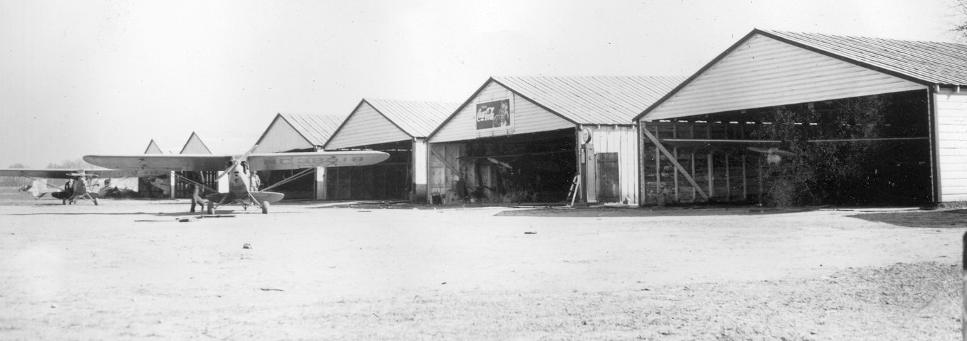
An undated (circa 1940s?) photo of several Piper Cubs in front of & inside the row of 6 individual hangars at the south end of Plaza Airport (courtesy of George Mihal of the Office of Image Archeology).
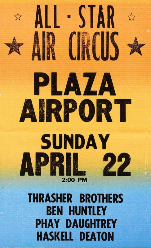
A circa late 1940s flyer for Plaza Airport's “All-Star Air Circus” (courtesy of Dave Stevenson).
Dave recalled, “The Thrasher Brothers featured their Twin Encoupe.
Ben Huntley was a well-known pilot from Mooresville. And of course Haskell Deaton was the owner of Plaza Airport.”
The 1948 USGS topo map depicted Plaza Airport as having a single unpaved northeast/southwest runway, with 7 hangars on the southeast side.
The last photo which has been located of Plaza Airport was a 5/14/48 USGS aerial view.
It depicted the north-northeast/south-southwest unpaved runway, along with the former west-northwest/east-southeast strip,
and a row of hangars on the south side.

The last aeronautical chart depiction which has been located of Plaza Airport was on the October 1948 Charlotte Sectional Chart (courtesy of Chris Kennedy).
It depicted Plaza as a municipal/commercial airport.
Plaza Airport was evidently closed at some point between 1950-60,
as a 1960 aerial photo showed new homes & streets covering the site,
with no trace remaining of Plaza Airport.
A 2014 aerial view showed a residential neighborhood covering the site of Plaza Airport, with no recognizable trace remaining of the former airport.
The site of Plaza Airport is located north of the intersection of The Plaza & Vickery Drive.
Thanks to Eric Karnes for pointing out this airfield.
____________________________________________________
Albemarle Airport, Albemarle, NC
35.34 North / 80.18 West (Northeast of Charlotte, NC)
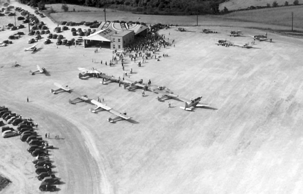
A 6/4/47 aerial view of the grand opening of the Albemarle Airport (from the Stanley County Museum, courtesy of Louis Bramlett).
This small general aviation airport on the southeast side of the town of Albemarle had its grand opening on 6/4/47,
as described in an article entitled “Large Crowds Witness Thrilling Aerial Show” in the 6/6/47 Stanly News & Press (from the Stanley County Museum, courtesy of Louis Bramlett).
It said, “More than 4,000 persons from this & other sections of the state were in attendance at Albemarle’s first air show Wednesday afternoon,
marking the official opening of the new Albemarle Airport southeast of the city.
A continuous program of flying stunts, free rides, and demonstrations of aircraft by local & visiting airmen & distributors,
kept the crowds thrilled and entertained from 1 o’clock until evening.
An interesting highlight of the afternoon was the plane ride taken by Mrs. Priscilla Jane Andrews, 85 year old Albemarle woman,
who was piloted on her first air trip by a crippled pilot John Brines of near Albemarle.
Upon alighting from the plane Mrs. Andrews said she 'felt fine, enjoyed every minute of it, and never felt nervous.'”
The article continued, “The crowd loudly applauded Mrs. Andrews, who was introduced over the loudspeaker by Haskell Deaton, owner of the Plaza airport in Charlotte.
Mr. Deaton & Alonzo Squires, popular radio announcer of station WAYS of Charlotte, served as masters of ceremonies throughout the afternoon.
Many pilots were on hand to fly the 27 planes participating in the colorful air show.
Among these were John Kiker, C.H. Brigman & Foyle Hightower of Wadesboro; Ed Brockenbrough & Mrs. Brockenbrough,
Mr Deaton, and Ted Meadows, of Charlotte; Clay Swain of Salisbury, Buck McKenzie of Sanford & Jack Gregory of Atlanta, GA.,
and other representatives from practically all airports in the state.
Mr. Brockenbrough thrilled the crowd by flying his plane 3 times under electric wires running along the edge of the field.
Mr. Kiker received a big hand when he rolled his Searman PT-17 into a half inside loop from an inverted position.”
The article continued, “The air show ended shortly after 6 o’clock when Dolan Poplin, of this city, a paratrooper with a record of 36 jumps during his army service,
opened his professional jumping career with a jump from the Stearman piloted by Hazel Smith, one of the 4 owners of the field.
From an altitude of 3,000' Poplin floated to earth.
By a miscalculation of windage, the parachutist landed unhurt in a field several hundred yards outside the bounds of the airport.
The owners of the field, including Mr. Smith, J.C. Holbrook, Chad Efird and Silas P Dennis,
received many words of congratulations on the excellent program they arranged for the official opening of the Albemarle airport.”
The article continued, “It was announced at the show that flying training would be started at the field in the near future.
The owners have already been notified that the concern, designated as the Stanly Aircraft Sales & Service, Inc.,
has been approved as a training center for veterans wanting to take flying lessons under the provisions of the GI educational bill.
In addition to offering flying training, the owners have 5 planes for charter trips & short rides.
The Stanly Aircraft Sales and Service, Inc will also serve as local distributors for various types of aircraft.”
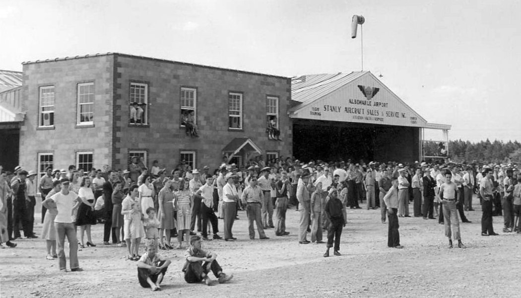
A 6/4/47 photo of the crowds viewing the grand opening of the Albemarle Airport (from the Stanley County Museum, courtesy of Louis Bramlett).
However, Albemarle Airport was not yet depicted on the 1948 Charlotte Sectional Chart.
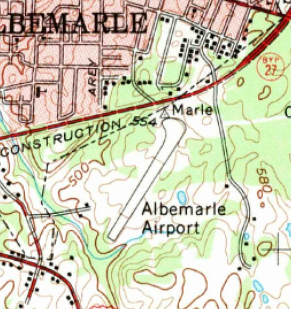
The earliest map depiction which has been located of the Albemarle Airport was on the 1955 USGS topo map,
which depicted Albemarle as having a single northeast/southwest runway.
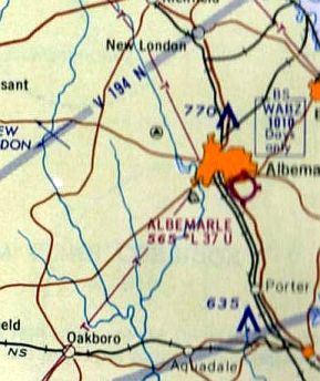
The only aeronautical chart depiction which has been located of Albemarle Airport was on the 1962 Charlotte Sectional Chart,
which depicted Albemarle as having a 3,700' unpaved runway.
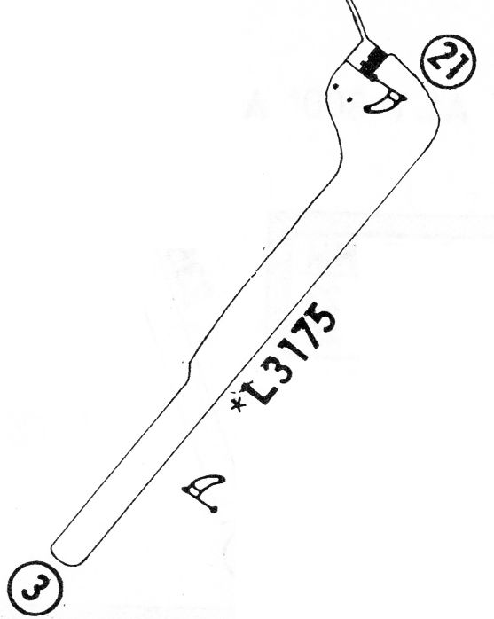
The 1968 Flight Guide (courtesy of Bob Levittan) depicted Albemarle Airport as having a unpaved 3,175' Runway 3/21,
with a building at the north end.
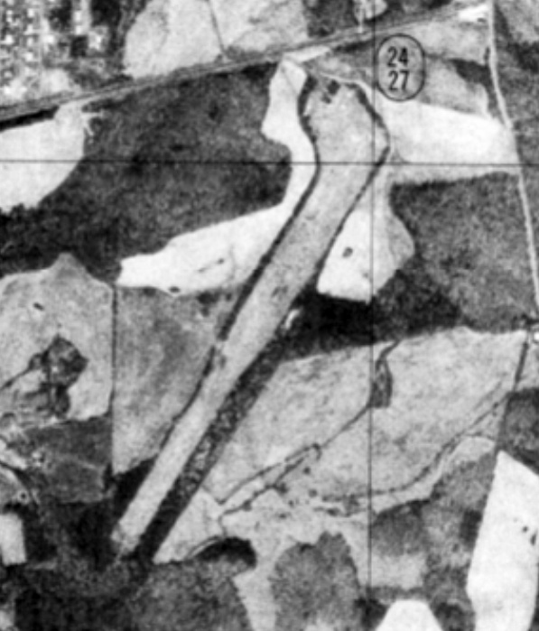
The only photo to be located showing Albemarle Airport in operation was a 1977 USGS aerial photo.
It depicted Albemarle as having a single northeast/southwest runway, with a few small buildings on the north side.
The larger Stanley County Airport opened in 1979 to the northeast of Albemarle, at which point Albemarle Airport presumably was closed.
The 1982 USGS topo map still depicted the runway & one small building, but labeled as “Abandoned Airport”.
A 1/22/93 USGS aerial view looking south showed that a shopping center had been built over the northeastern corner of the site of Albemarle Airport,
but several airport buildings & most of the runway remained intact.
A 1998 aerial photo showed that the Albemarle Airport buildings remained standing.
A 2005 aerial photo showed that a larger building (a Wal Mart) had covered the site of the Albemarle Airport buildings.
A 2/8/13 aerial view looking south showed that a Wal Mart covers the northeastern corner of the site of Albemarle Airport,
but the former runway remains recognizable extending away toward the southwest.
The site of Albemarle Airport is located south of the intersection of route 73 & Leonard Avenue.
Thanks to Michael Price for pointing out this airfield.
____________________________________________________
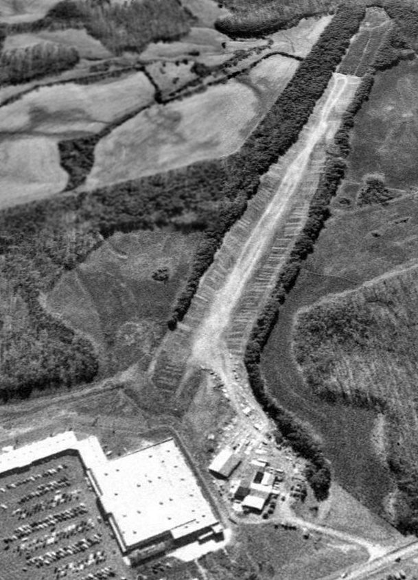
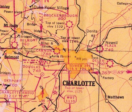
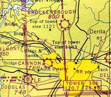
(Original) Charlotte Airport / Cannon Airport, Charlotte, NC
35.24, -80.89 (Northwest of Downtown Charlotte, NC)
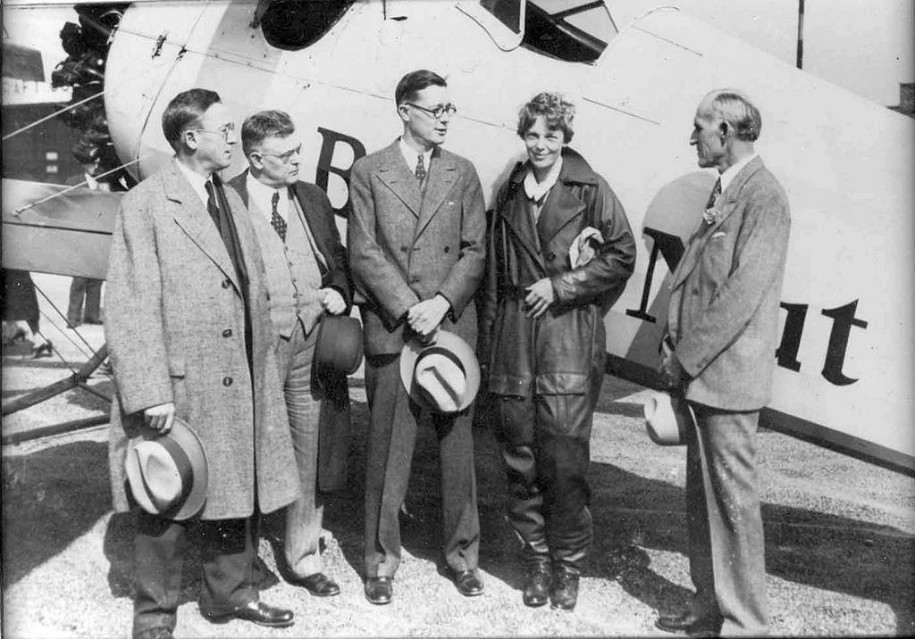
A 1931 photo of Amelia Earhart visiting Charlotte (presumably at Cannon Airport) as part of a promotional tour sponsored by Beech Nut chewing gum.
To her right is Chamber of Commerce President Clarence Kuester.
According to Ben Brockman, “Charlotte’s main airport during the 1920s, 1930s and 1940s, Charlotte Cannon Airport,
was built on the remnants of Camp Greene’s airfields.”
According to the Charlotte-Mecklenburg Historic Landmarks Commission,
“Prior to the building of Douglas Airport, flights in & out of Charlotte were rare.
The Queen City’s only airfield was Charlotte Airport (later known a Cannon airport),
a small private venture operated by Johnny Crowell, a famed Charlotte aviator.
Although this landing strip was christened amid much fanfare as an airmail stop on 4/1/30,
with passenger service from Eastern Air Transport (later Eastern Airlines) following a few months later,
the field was only open on weekends, for air shows, and war-pilot training.”
Eric Carnes observed, “Cannon's problem was that it was somewhat hemmed in & had gravel runways,
and when the airlines started talking in the late 1920s about coming to Charlotte they decided Cannon was inadequate.”
The earliest depiction of the airfield which has been located
was a 1931 photo of Amelia Earhart visiting Charlotte (presumably at Cannon Airport)
as part of a promotional tour sponsored by Beech Nut chewing gum.
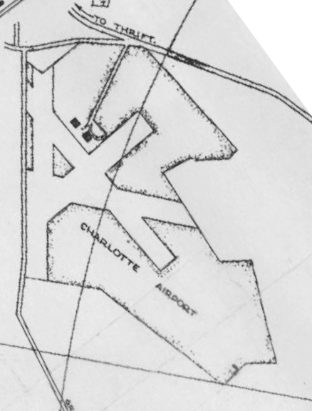
The Chamber of Commerce's 1935 “Official Map of Charlotte” depicted “Charlotte Airport”
as having 4 runways & 2 hangars on the north side.

The field had been renamed Cannon Airport at some point between 1935-42,
as that is how it was labeled on the Chamber of Commerce's 1942 “Official Map of Charlotte”.
The airfield configuration remained unchanged compared to the 1935 map.
Bill Thomas recalled, “Cannon Airport... I used to hang out there as a kid in the 1940s
and remember going there on my bike to look at a T-6 that a couple of drunks crashed after a night of partying!
This was during WW II and there were a couple of MPs standing guard & not allowing any of the kids to climb on the plane.”
The earliest aeronautical chart depiction which has been located of Cannon Airport was on the 1944 Charlotte Sectional Chart (courtesy of David Stevenson).
It depicted Cannon as a municipal/commercial airport.
The last photo which has been located of Cannon Airport was a 5/15/48 USGS aerial view.
It depicted Cannon as having 3 unpaved runways & 4 hangars,
but no aircraft were visible on the field.
The last aeronautical chart depiction which has been located of Cannon Airport was on the October 1948 Charlotte Sectional Chart (courtesy of Chris Kennedy).
It depicted Cannon as a municipal/commercial airport.
The 1949 USGS topo map depicted Cannon Airport as having 3 runways & 4 hangars.
Cannon Airport was evidently closed at some point between 1948-60,
as a 1960 USGS aerial photo depicted a large number of trailers being stored in front of the hangars.
Cannon Airport was no longer depicted on the 1962 Charlotte Sectional Chart.
The 1965 USGS topo map continued to depict Cannon Airport in an unchanged fashion.
A 1968 USGS aerial photo continued to show Cannon Airport as remaining intact, though deteriorated.
Cannon Airport was no longer depicted on the 1970 USGS topo map,
which instead depicted clearings in the shape of the runways,
still depicted the 4 hangars, and a survey marker named Cannon.
A 1971 aerial photo showed that a drive-in movie theater had been built over the eastern portion of the Cannon Airport site.
But the 4 hangars remained standing.
The 1978 USGS topo map continued to depict the site of Cannon Airport in an unchanged fashion.
A 1978 USGS aerial photo showed that Freedom Mall had been built over the northern portion of the Cannon Airport site,
covering the site of the hangars & removing the last traces of the airport.
According to Eric Karnes, “Freedom Mall was one of the first malls in Charlotte.
It was ultimately turned into a city & county social services complex some years ago.”
The 1996 USGS topo map continued to depict a survey marker named Cannon.
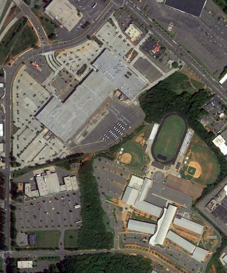
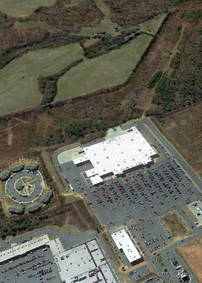
An 8/24/12 aerial view showed no trace remaining of Cannon Airport.
The site of Cannon Airport is located east of the intersection of Ashley Road & Lindbergh Street, appropriately enough.
Thanks to Eric Karnes for pointing out this airfield.
____________________________________________________
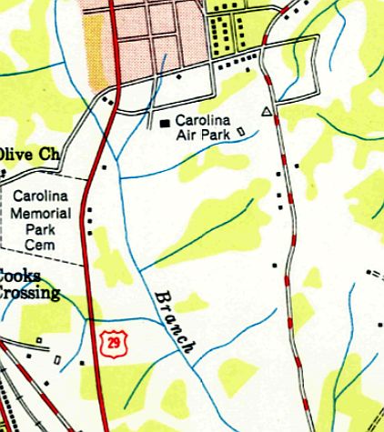
Carolina Air Park / Carolina Skypark, Kannapolis, NC
35.46, -80.61 (Northeast of Charlotte, NC)
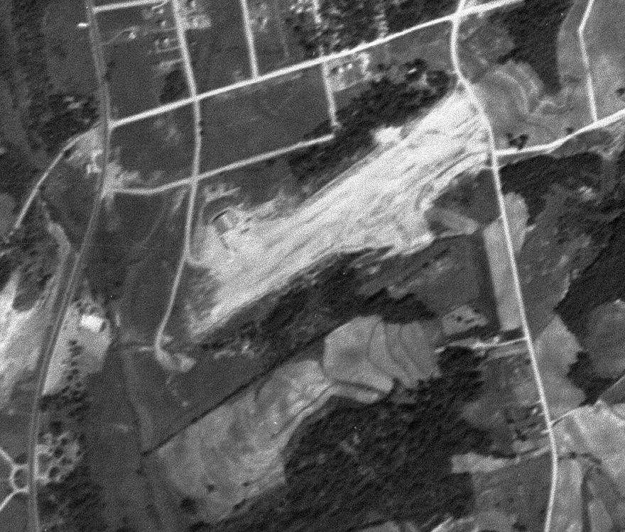
A 5/15/48 USGS aerial view of Carolina Air Park.
This small general aviation airport had a very brief existence.
It was evidently established at some point between 1945-48,
as it was not yet depicted at all on the April 1946 Charlotte Sectional Chart (according to Chris Kennedy).
The earliest depiction which has been located of Carolina Skypark was a 5/15/48 USGS aerial view.
It depicted Carolina Skypark perhaps soon after its construction, with a single unpaved northeast/southwest runway which appeared to be newly-cleared,
and a single arch-roof hangar on the northwest side.
The earliest aeronautical chart depiction which has been located of Carolina Skypark
was on the October 1948 Charlotte Sectional Chart (courtesy of Chris Kennedy).
It depicted “Carolina” as a commercial/municipal airport.
The last labeled depiction which has been located of Carolina Air Park was on the 1950 USGS topo map.
It depicted Carolina Air Park simply as an open area with 2 small buildings along the north side.
According to Jonathan Cox, “I believe its name was Carolina Skypark.
I know it was operational during the 1950s.”
Carolina Air Park was evidently closed (for reasons unknown) at some point between 1948-53,
as it was no longer depicted at all on the 1953 USGS topo map
nor on the August 1954 Charlotte Sectional Chart (according to Chris Kennedy).
No airfield-related features were depicted at the site on the 1974, 1984, or 1991 USGS topo maps.
The former hangar was visible in a 1998 USGS aerial photo,
but the surrounding area had been built upon,
and no obvious trace of any former runways was still recognizable.
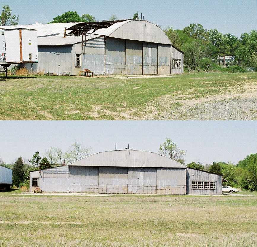
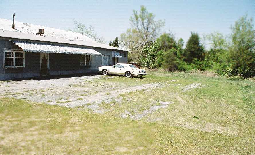
Two 2006 photos by Jonathan Cox of “the only remaining building at the former Carolina Skypark - the old hangar,
that finished its life as an equipment storage building for the C.G. Tate Construction Company,
and still has the company's name painted on the side.”
Note the large hole in the roof.
A 2006 photo by Jonathan Cox of “an overgrown concrete area on one side of the hangar, possibly the former ramp area.”
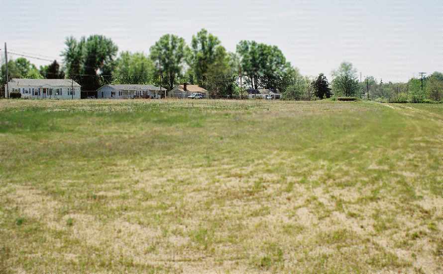
A 2006 photo by Jonathan Cox of “the grassy area in front of the hangar looking toward Skyway Drive.
The area in front of the hangar may have been the location of the runway(s).”
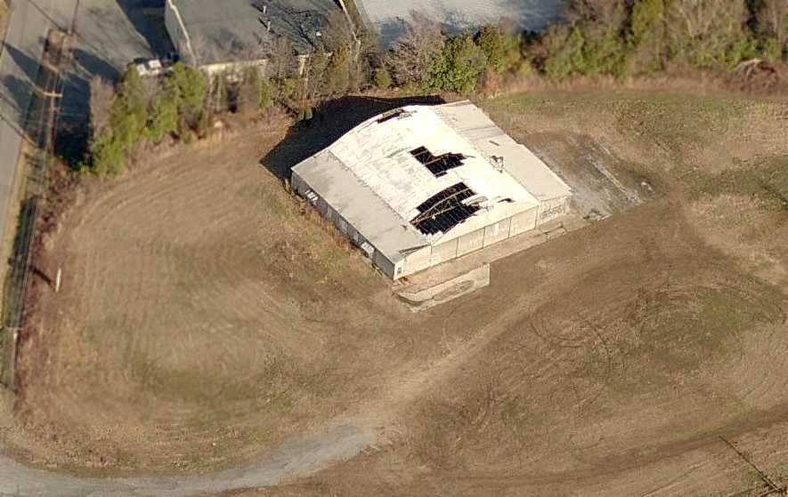
A circa 2006 aerial view looking north at the former Carolina Air Park hangar, showing the large holes in its roof.
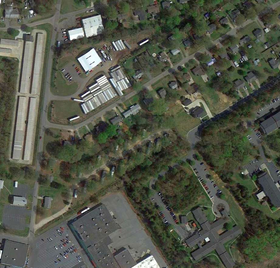
A 4/9/13 aerial view showed the former hangar (white building at top-left) remained standing,
but the surrounding area had been built upon & no obvious trace of any former runways was still recognizable.
The site of Carolina Air Park is located northeast of the intersection of Pennsylvania Avenue & Skyway Drive.
Note that the next street to the south is named Airline Drive.
Thanks to Jonathan Cox for pointing out this airfield.
____________________________________________________
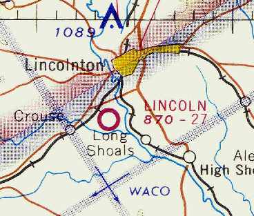
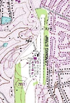
Lincoln Airport, Lincolnton, NC
35.43 North / 81.27 West (Northwest of Charlotte, NC)
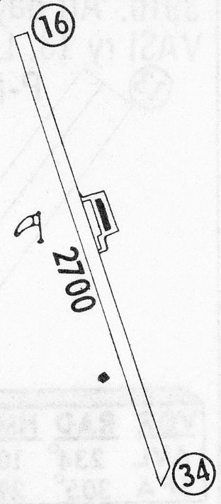
Lincoln Airport, as depicted in the April 1966 Charlotte Sectional Chart (courtesy of Chris Kennedy).
Photo of the airfield while open has not been located.
This small general aviation airport was evidently established at some point between 1963-65,
as it was not yet depicted at all on the May 1963 Charlotte Sectional Chart (according to Chris Kennedy).
The earliest reference to the Lincoln Airport which has been located
was in the 1965 Jeppesen Airway Manual (according to Chris Kennedy).
It listed Lincoln Airport, but did not provide any depiction of the field.
The earliest depiction of the Lincoln Airport which has been located
was on the April 1966 Charlotte Sectional Chart (courtesy of Chris Kennedy).
It depicted Lincoln Airport as having a 2,700' unpaved runway.
The 1968 Flight Guide (courtesy of Bob Levittan)
depicted Lincoln Airport as having a single 2,700' unpaved Runway 16/34.
A small ramp was depicted on the east side of the runway with a single building.
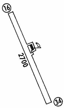
The 1971 Flight Guide (courtesy of Chris Kennedy)
depicted Lincoln Airport as having a single 2,700' unpaved Runway 16/34.
A small ramp was depicted on the east side of the runway with a single building.
The 1980 AOPA Airports USA Directory (according to Chris Kennedy)
described Lincoln Airport as having a 2,700' dirt runway.
The Lincoln Airport was apparently closed (for reasons unknown) at some point between 1980-82,
as it was no longer listed among active airfields in the 1982 AOPA Airports USA Directory (according to Chris Kennedy).
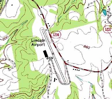
The 1996 USGS topo map still depicted Lincoln Airport, even though it may already have been closed for several years at that point.
It appeared to depict the field as having a single northwest/southeast paved runway,
along with a single building (a hangar?) along the west side of the field.
The 1998 USGS aerial photo showed several large buildings had been built over the Lincoln Airport property.
A 4/2/11 aerial photo showed several large buildings convering the site of Lincoln Airport,
but a careful examination reveals the remnants of the northwestern end of the runway & taxiway.
The site of the Lincoln Airport is located at the intersection of Indian Creek Road Kawai Road.
Thanks to Brett Kepner for pointing out this airfield.
____________________________________________________
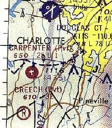
Carpenter Airfield, Charlotte, NC
35.14 North / 80.97 West (South of Charlotte Douglas International Airport, NC)
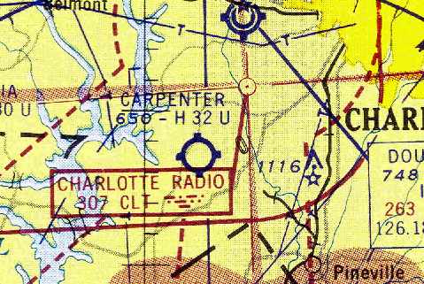
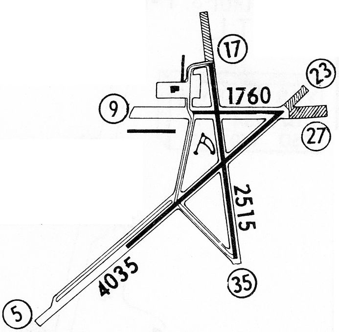
Carpenter Airfield, as depicted on the July 1959 Charlotte Sectional Chart (courtesy of Chris Kennedy).
According to David Jenkins, “Carpenter Airport was built & owned by my Great Uncle, Colonel Owen Carpenter,
upon his retirement from the US Air Force after WWII.
The airport was constructed on what was once the family cotton farm & many enjoyed learning to fly at Carpenter.
Lee Smith & Jack Thompson operated the airfield for my great uncle under the name of Smith Regal Aviation.
One notable 'barn stormer', Johnny Crowell, was a frequent flyer from Carpenter.”
Stephen Hill recalled, “When I was young & spending summers hanging-out at that airport,
Lee Smith was a 'larger than life' kinna fellow, frequently yelling at the top of his lungs (back in his office with the door closed, at least)
where he took pilots to burn-em-a-new-one after they made big mistakes or were boneheads.”
Carpenter Airport was not yet depicted on the August 1954 Charlotte Sectional Chart (according to Chris Kennedy).
The earliest reference to Carpenter Airport which has been located
was on the July 1959 Charlotte Sectional Chart (courtesy of Chris Kennedy).
It depicted Carpenter as having a 3,200' hard-surface runway.
Bill Francis recalled, “As a 16 year old, I spent many Saturdays at Carpenter's
and was able to take a few lessons in one of their Champs. When I could afford them.
I remember 2 crossed runways. I don't remember either as paved.
This was in about 1959 & 1960.”
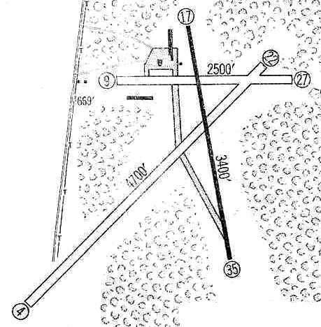
The 1959 Jeppesen Airway Manual (courtesy of Chris Kennedy)
depicted Carpenter Field as having a 3,400' paved Runway 17/35, a 4,700' unpaved Runway 4/22,
and a 2,500' unpaved Runway 9/27.
A taxiway led to a ramp on the north side of the field, with several small buildings (hangars?) around it.
Bill Francis observed, “I think that the paved runway at Carpenter's was installed when Runway 4/22 was closed
due to the construction of the Westinghouse Turbine Plant & the construction of Westinghouse Boulevard to connect it to NC Highway 49.
But, this is just conjecture.”
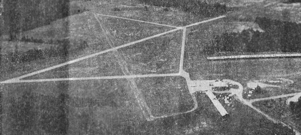
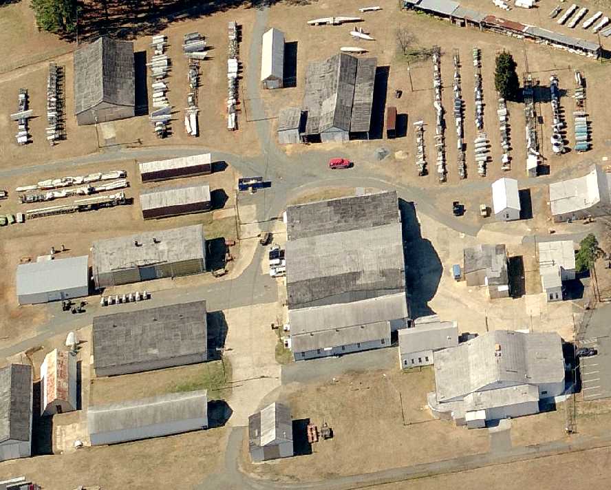
The earliest photo which has been located of Carpenter Airport was a 1960 aerial view.
It depicted the field as having 3 runways, with 10 aircraft & 3 hangars on the west side of the field.
One hangar was 630' feet long, and was prominently painted with “Carpenter Airport Charlotte” along the length of its roof.
The 1962 AOPA Airport Directory described "Carpenter" Airfield
as having a 3,300' asphalt Runway 18/36, a 4,700' turf Runway 4/22, and a 2,500' turf Runway 9/27.
The field was said to offer fuel, repairs, hangars, tiedowns, and charter.
The operator was listed as Smith Regal Aviation (also a Champion & Mooney dealer).
Stephen Hill recalled, “My father (Odell Hill) was a Certified Flight Instructor who flew students out of Carpenter Airport back in the 1960s as a PT labor of love.
I still remember many things about Lee Smith: big old Cadillacs, Lincolns littered all over the airport, Acorn Gumball sales,
one of if not the very first BMW Izetta franchises, MotoGuzzi motorcycles.
Jack Thompson (wore Stetsons & boots) and Johnny Crowell (drove a black Ford Thunderbird with hardtop & porthole windows).
He used to give me and my younger brother nickels so we could buy a 12 ounce Coke & a pack of Lance peanuts,
then Mr. Crowell would show us the proper way to pour some of your peanuts into the Coke bottle, then drink & eat them out.
Crazy, but the best memories ever!
I really miss that old airport; I have many happy memories from Saturdays & Sundays spent out there during those 1960s summers.”
Stephen continued, “I can also remember different young men who were building hours at Carpenter in order to go to work for the majors like Piedmont or Eastern Airlines.
I could share some kindnesses showed to myself & my younger brother by barnstorming legend Johnny Crowell, who I can vividly remember. He was a great old boy.
Another flier was an athletic blond named Bob Mobley.
He asked me once if I wanted to go flying with him, and he did say he would be doing some spins & loops, but thinking I was 'all that' & a 12 year old bag a chips, I took him up on it.
He took us up in what I remember to be a Citabria, tandem seater, and started doing aerobatics of all types.
It was fun for about the first 4-5 loops & then spins (which were terrifying) until the horizon & sky merged into a spinning wheel in the sky,
and my stomach & tonsils were shaking hands on a pretty frequent basis.
I soon notified said pilot I was sick as a dog, who being a sympathetic & merciful guy, handed me a paper sick-bag & told me to sit back and enjoy it?
He then continued wringing that airplane out for all it was worth.
I never felt so glad to be back on terra firma, and I literally laid prone on the ground until the worst nausea passed.
That was my last aerobatic ride to this very moment.”
Charlie recalled, “Carpenter Airport... I learned to fly at this airport in 1965.
At that time it was owned or run by a Col. Carpenter.
I have several photos of me & the plane, also Ben Zimmer of W. Zimmer & Sons had their plane there.”
Carpenter Airport was not yet depicted at all on the 1965 USGS topo map.
A 1965 aerial photo depicted the field in the same confirmation as seen in 1960,
except only 5 light aircraft were visible.
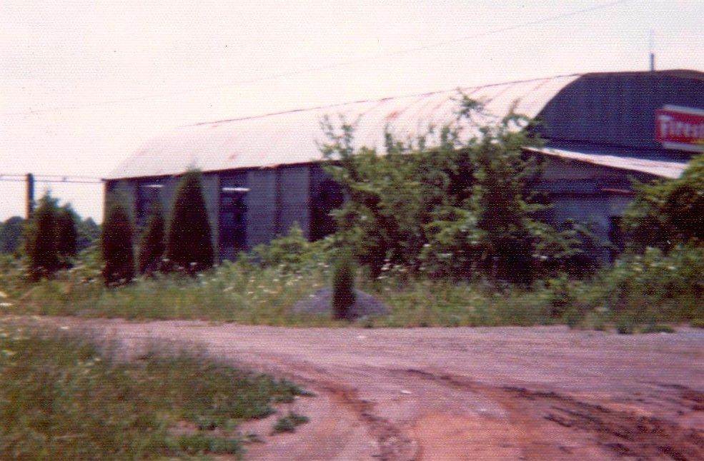
An undated aerial view looking south at Carpenter Airport from a 7/29/67 newspaper article (courtesy of David Jenkins).
The article reported that “Carpenter Airport is offered to City, City isn't buying – Adviser.”
It said that Owe Carpenter offered to sell his airport to the city for $750,000.
A 1968 aerial photo depicted the field in an unchanged manner.
The 1968 Flight Guide (courtesy of Bob Levittan)
depicted Carpenter Field as having 3 unpaved runways each of which had a shorter paved portion.
A taxiway led to a ramp on the north side of the field, with several small buildings (hangars?) around it.
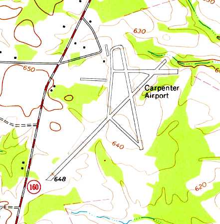
The 1968 USGS topo map depicted Carpenter Airport as having a 3 runways, and 3 hangars on the west side.
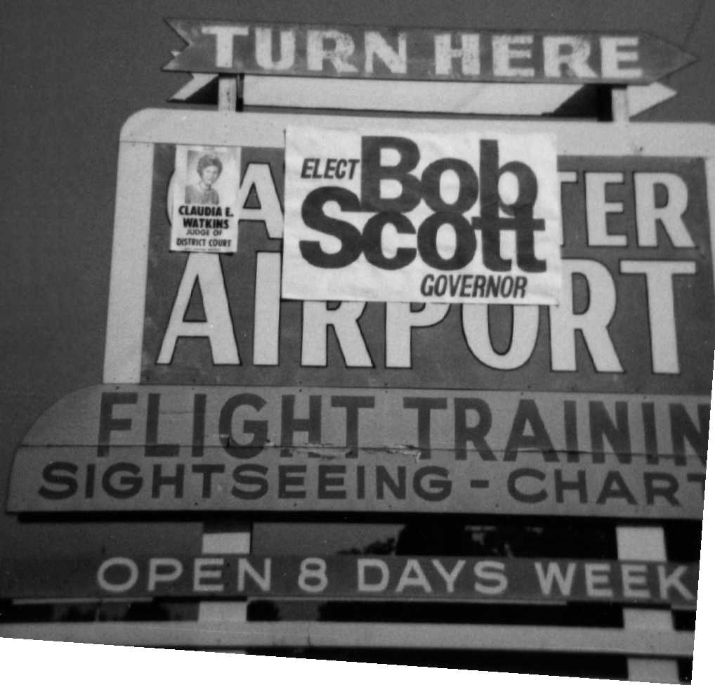
A circa 1968 photo of the entrance sign for Carpenter Airport (courtesy of David Jenkins).
David noted that the sign declared the airport “Open 8 Days Weekly”,
but “Too bad political signs obscured parts of the sign when the photo was taken.”
At some point between 1962-72, the status of the field apparently changed to that of a private field,
as that is how "Carpenter" was depicted on the August 1972 Charlotte Sectional Chart (courtesy of Robert Brown).
It was depicted as having 2 paved runways, with the longest being 3,200'.
Bill Francis recalled, “Carpenters succumbed to development sometime in the early 1970s.
I worked nearby from 1973-84 & remember driving up Westinghouse Boulevard
and looking down what would have been Runway 4 with regret.
The runway would have actually extended across Westinghouse.”
It was still depicted as "Carpenter" Airfield on the 1974 USGS topo map.
A circa 1974 photo of Carpenter Airport's maintenance hangar (courtesy of David Jenkins).
A 1978 aerial photo showed that the majority of the length of the runways remained intact,
but a commercial building had been built over the south end of Runway 35.
The hangars still remained standing, including the 630' long hangar painted with “Carpenter Airport Charlotte” along the length of its roof.
According to David Jenkins, “As industry & highway construction divided the property, the airport essentially ceased operation.
The land was all sold by 1980.”
Gregory Jordan recalled, "I located the access road around 1980 or so
and drove out to a fence where you could see the runways & some old hangars.
It was all very grown up with brush. I think there was an old single-engine plane there too."
Stephen Hill recalled, “I went back out to the airport in the early 1980s;
one of the hangars was still there but had been vandalized, and Carpenter did have at least 1 & possibly 2 paved asphalt runways.”
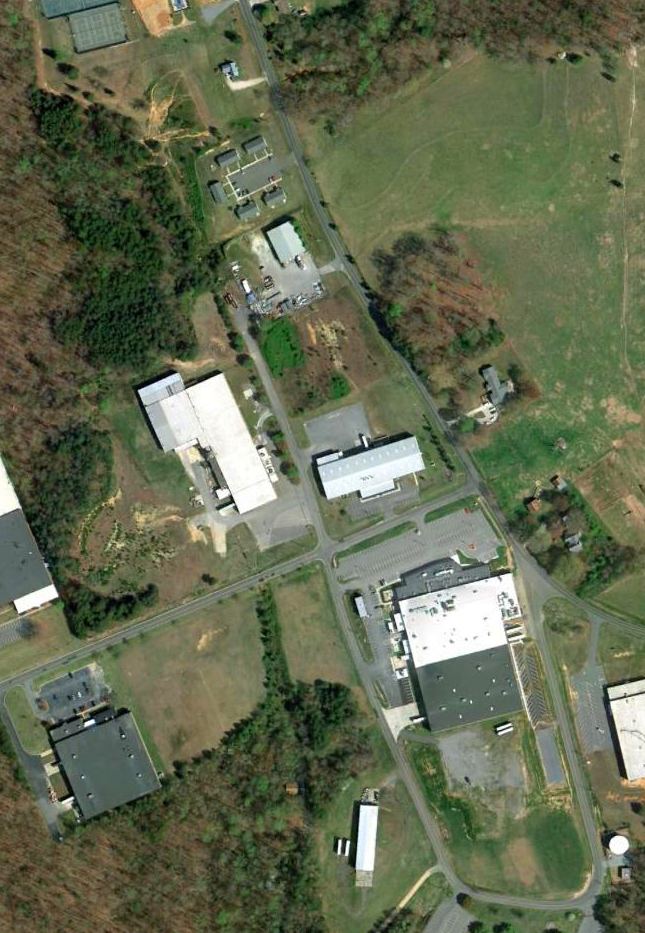
By the time of the 1998 USGS aerial photo, the site of the former airport had been covered by an industrial park,
with several streets (Westinghouse Commons Drive & Westlake Drive)
and buildings having covered any remaining trace of the former airport.
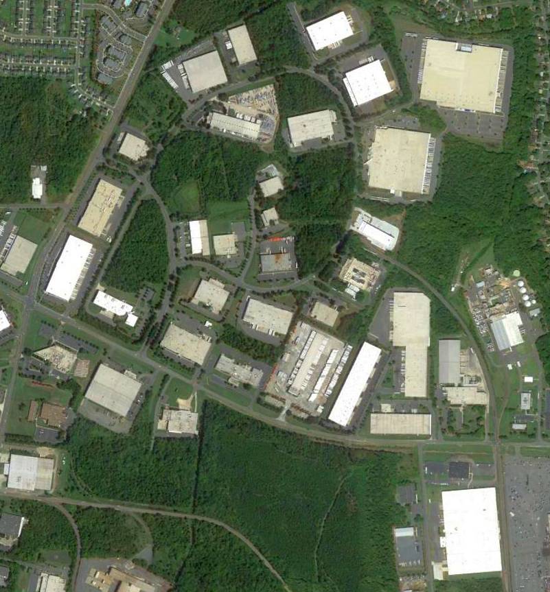
A 8/24/12 aerial photo showed not a trace appears to remain of the former Carpenter Airport.
According to David Jenkins, “A wooden directional road sign which reads 'Carpenter Airport' is the only tangible remainder/memory of the airfield.
That sign hangs in my workshop.”
The site of Carpenter Airfield
is located northeast of the intersection of Westinghouse Boulevard & Steele Creek Road.
Thanks to Gregory Jordan for pointing out this airfield.
____________________________________________________
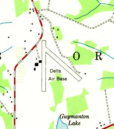
Delta Air Base (NC24), Charlotte, NC
35.21, -80.72 (East of Downtown Charlotte, NC)
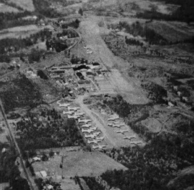
A 12/13/42 aerial view looking east at Delta Air Base from the 1945 AAF Airfield Directory (courtesy of Scott Murdock).
This small civilian airport with a military-sounding name was evidently established at some point between 1941-42,
as it was not yet depicted on the May 1941 14M Regional Aeronautical Chart (according to Chris Kennedy).
The earliest depiction which has been located of Delta Air Base
was a 12/13/42 aerial view looking east from the 1945 AAF Airfield Directory (courtesy of Scott Murdock).
It depicted Delta Air Base as having 2 unpaved runways & a hangar on the southwest side.
The earliest aeronautical chart depiction which has been located of Delta Air Base
was on the April 1944 Chattanooga Sectional Chart (courtesy of David Stevenson).
The 1945 AAF Airfield Directory (courtesy of Scott Murdock) described Delta Air Base
as a 164 acre irregularly-shaped property within which were 2 sod runways, measuring 3,100' north/south & 1,800' northwest/southeast.
The field was said to have 2 hangars, with the largest being a 100' x 80' metal structure,
and to be privately owned & operated.
“Delta” was depicted as a commercial/municipal airport
on the October 1948 Charlotte Sectional Chart (courtesy of Chris Kennedy).
The 1949 USGS topo map depicted Delta Air Base as having 2 runways, with 4 buildings along the west side.
A 1960 aerial photo depicted Delta Air Base as having a primary north/south unpaved runway,
along with traces of the former northwest/southeast runway, and possibly a 3rd runway oriented east/west.
Two aircraft were visible along the west side of the field, including one fairly-large twin-engine aircraft.
Delta Air Base was listed as a private airfield in the 1962 AOPA Airport Directory,
with a single 3,100' turf Runway 18/36.
An aerial photo looking northeast at Delta Air Base from the 1963 NC Airport Directory,
which depicted at least 22 large piston-engine airliners (DC-3s & DC-4s?)
parked tightly together in a separate clearing adjacent to the south side of the field.
A 1965 aerial photo showed 4 aircraft along the west side, including what appeared to be 2 DC-3s/C-47s.
At some point between 1960-65, a field to the southwest had become an aircraft storage lot, holding a total of over 20 large twin-engine aircraft.
In the 1960s, Delta Air Base was the home of a bustling aircraft salvage operation.
Spurgeon McDade had the following experience at Delta:
"In 1965, a bunch of us had gone to Charlotte for a convention, sponsored by Hickory Grove Baptist Church.
As we wound down Albemarle & turned off on Hickory grove,
we spied the tail end of a large dirt strip.
In the background were DC-6s, a Connie, and all matter of wrecked planes.
As soon as we got to the church, 3 of us bolted, fled down the road to the base.
It was called "Charlotte" or "Carolina Airplane Salvage", and was not open to the general public.
There were some guys there who would not let us in past the office,
but let us look at some piles of B-17 & B-24 ball turrets stacked up 20-30' tall, B-17 & B-26 noses.
In the background of the hangars we could see a bunch of WW2 Corsairs, trainers, DC's,
even a couple of USMC jet Corsairs."
"Being the good obedient Baptists we were,
we left, ran down the road, & jumped the fence.
There were airliners set up on wooden pallets, fuselages damaged by fire,
more WW2 fighter & bomber wings, tails, turrets, parts,
and that Connie, that was every color of the rainbow, but intact & due to fly out within the next week or 2.
Some of the WW2 turrets had bullet holes in them, most of the parts showed some damage,
and even though we were in heaven,
we soberly realized that we were looking at remains of planes that had experienced & wrought death."
A 1968 aerial photo showed that houses had covered the eastern portion of Delta's former crosswind runway at some point between 1965-68.
One fairly-large twin-engine aircraft was visible on the west side of the field.
The number of aircraft visible in the storage lot to the southwest had decreased somewhat to 17, since the 1965 photo.
Rick Caston recalled, “There never were 2 'B-26s' at the company.
There was an A-26 that sat out in the very back of the bone yard which was indeed flown out somewhere around 1971.
The reason I know this is because my dad worked there for 32 years
and I played in many of these airplanes on Saturdays when I went to work with him.
The A-26 was sold to an air race pilot named Jack Sliker who traded a Piper Super Cub for it.
My Dad kept me out of school the day THE A-26 was supposed to fly out but they ran into a few problems & put it off for a few days.
Not knowing exactly when Jack would take it out I wasn't able to see the actual departure.
I used to fly the Super Cub after I soloed in 1972.
I also worked for CAC while in high school & during my summer vacations from college.
Jenks Caldwell Sr. helped me get my pilot job at Piedmont in 1985.
During the 1960s when I was there a lot I know that I played in THE A-26 with my brothers.
We also spent time in the American Airlines DC-6Bs, the United DC-7s, Piedmont's DC-3s, and Martin 404s.
There was never any machine guns in these airplanes & certainly not the ONE A-26.
I too worked in 'Inventory' part time each day after high school until I graduated in 1974.
After that I worked again in 'Inventory' during my summer breaks from The Citadel.
We worked in the warehouses with parts as well at the smelter.
I certainly do not remember a Connie ever leaving. I don't recall one ever being there.”
By the time of the August 1972 Charlotte Sectional Chart (courtesy of Robert Brown),
Delta's runway had been lengthened to 4,200'.
Steve Richardson recalled, "One of my first summer jobs (1973) was in this salvage yard,
which made a huge impression on an airplane-minded kid like me.
For years you could see two Douglas B-26s parked near the fence just inside the entrance,
on the 'front' side of the facility.
In fact a classmate of mine sneaked over the fence one night & stole two 0.50 caliber machine guns from one of the aircraft,
leading the Charlotte Aircraft folks to remove the rest & store them more securely.
The first photograph I ever took in my life was in the cockpit of one of these B-26s.
Later the B-26s were flown out (not easy, since the runway was bisected by a drainage ditch)
and their place was taken by a pair of Martin 404s marked 'Cruzeiro do Sul'.
The rumor was that the B-26s were headed for some clandestine operator & I never heard any more about them."
"There were actually two businesses sharing Delta Air Base in 1973, Charlotte Aircraft and 'Equipment & Supply'.
Charlotte Aircraft did mostly mainstream parts repair,
while Equipment & Supply concentrated on the salvage part of things.
I worked for Equipment & Supply, my brother worked for Charlotte Aircraft.
Equipment & Supply would buy job lots of surplus government stuff, clean up the parts & resell them.
My jobs included driving the forklift, wire-brushing rust & cosmolene off the parts,
recording any numbers that I could find, and filing the info in a card file so it could be matched against customer parts requests.
There were many aircraft in the back as shown in the photo from 1963 [above], DC-3s & things like that.
What doesn't show is the small stuff.
In the dead center of that photo, just before the RH line of old hulks, there was a jet fighter fuselage.
I thought it was an F-80 but inside the gun doors it said P-80, meaning it predated the 'F' numbering convention.
Next to it was an F-84 fuselage, with the wings removed & lying nearby.
Both of these aircraft had been stripped of anything useful & were waiting to be melted down.
Down the back runway, though, there were two crates with F-86s inside,
appearing intact (wings removed & packed on edge on each side of the fuselages).
I asked my boss how much he'd sell the jets for,
and he said $100 for either the P-80 or F-84 but he'd have to have $200 each for the Sabres!
Well, I was making $1.35 an hour & trying to save money for college, so that wasn't possible - too bad!"
"There were racks of canopies going milky in the sun & piles of drop tanks in the 'front' part of the yard.
Then came the buildings that are apparently still there.
Then in the back there were stacks of wooden boxes holding radars & other electronic equipment,
with the top box unpacked & its contents left out to show what was in all the others.
Crude inventory management!
There were engine storage containers too, with R2800s & other engines in a state of semi-preservation.
Inside the Charlotte Aircraft buildings there was a room full of all kinds of aircraft maintenance manuals.
In our Equipment & Supply area there were the original wood molds for making B-26 clear plexiglass noses.
There was a cockpit mockup of the XB-43.
There were stacks of steel tube trussed fuselages for training planes
(and one complete, skinned BT-13 fuselage in the boneyard).
It was just a fabulous place for an aircraft buff."
"Many years after working there, I called to see if any of the aircraft or parts were left.
I was told that they had all been melted down years ago, and [the later aerial photos] seem to confirm this.
When I was there we were limited to 2 days, I believe, of smelter operations a month
because of pollution & the encroachment of residential housing.
They must have gotten a waiver for that, to get rid of all those airplanes.”
A 1978 aerial photo showed that there were no longer any aircraft alongside the runway,
and the number of mostly-intact aircraft recognizable in the storage lot to the southwest had dwindled to only 4.
The 1982 AOPA Airport Directory (courtesy of Ed Drury)
described Delta as having a single 4,200' Runway 18/36.
A 1985 aerial photo by Paul Cotrufo looking northeast at Delta Air Base.
The large number of transport aircraft previously visible in the 1963 aerial photo had been removed by this point.
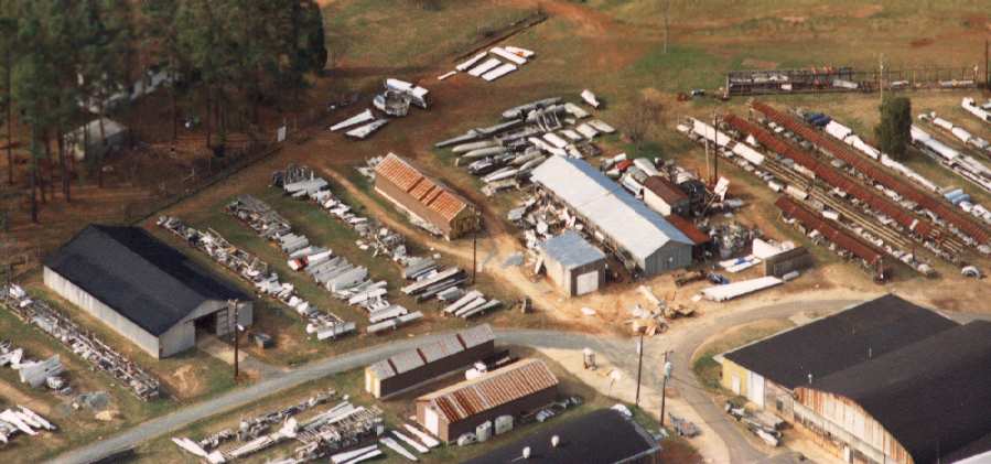
A 1985 aerial photo by Paul Cotrufo of the aircraft salvage yard at Delta Air Base.
On the 1996 USGS topo map, the runway's length had shrunked back to 3,000'.
The 1999 Charlotte Sectional Chart depicted Delta as a private airfield with a 3,000' unpaved runway.
As of 2002 Delta Air Base was listed as a heliport, and the published length of the runway had shrunken again, to only 1,000'.
As of 2002, the owner of Delta Air Base is listed as Charlotte Aircraft Corporation,
which apparently is still involved with aircraft salvage.
However, since at least the mid-1980s they have conducted
their active aircraft salvage operations at the Laurinburg-Maxton Airport,
which is a much bigger airport & isn't hemmed in by development like Delta Air Base.
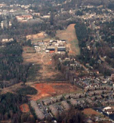
A circa 2006 aerial view looking west at the hangars, warehouses, and aircraft parts on the west side of Delta Air Base.
The 2009 Charlotte Terminal Aeronautical Chart no longer depicted Delta as an airfield or heliport.
In an 8/24/12 aerial photo of Delta air Base, a shortened portion of the grass runway remained clear,
and a large number of hangars still remained standing along the west side of the runway.
Delta Air Base is located northeast of the intersection of East Harris Boulevard & Albemarle Road.
____________________________________________________
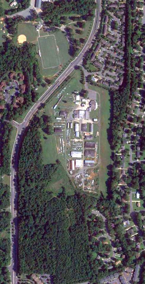
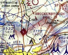
Brockenbrough Airport (9A3), Charlotte, NC
35.32, -80.84 (North of Downtown Charlotte, NC)
Brockenbrough Airport, as depicted on the 1945 Charlotte Sectional Chart (courtesy of John Voss).
Photo of the airport while open is not available.
Brockenbrough Airport was located on the grounds of the Metrolina Fairgrounds, adjacent to the southwest side of the racetrack.
Brockenbrough Airport may have been established at some point between 1944-45,
as it was not yet depicted at all on the November 1944 Charlotte Sectional Chart (according to Chris Kennedy).
The earliest depiction of the field which has been located
was on the 1945 Charlotte Sectional Chart (courtesy of John Voss),
which depicted Brockenbrough as a commercial airport.
The 1945 AAF Airfield Directory (courtesy of Scott Murdock) described Brockenbrough Field
as a 131 acre irregularly-shaped property within which were 2 turf runways, measuring 2,150 NNW/SSE & 1,900' northeast/southwest.
The field was said to have 2 hangars (depicted on the south side of the field), with the largest being a 94' x 40' wood & metal structure,
and to be privately owned & operated.
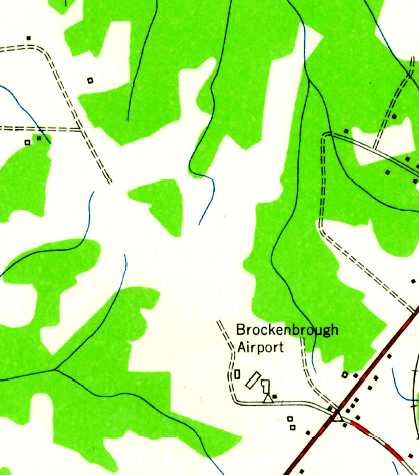
The 1948 USGS topo map labeled Brockenbrough Airport, and depicted several small buildings, but did not depict any runways.
Kevin Estes recalled that he & his father “went flying out of that airfield once or twice.
There was a salvage yard across from the entrance to the fairgrounds that held a lot of interesting items,
such as a gray Sherman tank & a lot of drop tanks & other airplane-related items.”
The earliest photo which has been located of Brockenbrough Airport was a 1960 aerial view.
It depicted the field as having 2 unpaved runways,
with a cluster of 6 individual T-hangars & 2 other small hangars, and one single-engine aircraft at the south side.
The 1962 AOPA Airport Directory described Brockenbrough Airport as having 2 sod runways:
2,700' Runway 15/33 & 1,800' Runway 4/22.
The operator was listed as E.H. Brockenbrough.
A 1965 aerial photo depicted Brockenbrough in basically the same fashion as the 1960 photo,
but there were no aircraft visible on the field.
James McDonald recalled, "I was a frequent flyer at Brockenbrough (pronounced brock-in-burr-oh) between 1965-67.
Mr. Brockenbrough had retired & the facility was operated by Henry (Hank) Dutch.
Hank was a CFI complete, an FAA flight examiner,
and piloted C-124 Globemasters for the Air Guard or Reserves.
He, his wife, a number of identical looking sons, each about a year apart,
and a big mutt named Bozo lived on-site.
Bozo loved to fly when he wasn't entertaining the hanger flyers
by running, then jumping & sliding through an inch of water on the floor of an abandoned hangar.
The stable included two Cherokee 140s, two Cherokee 150s, one Cherokee 180,
and a lone Apache for some economical twin time (I think dual in the Apache went for $35/hr).
By the way, I had a forced landing in one of the 140s courtesy of a complete engine failure."
James continued, "This place was a Mecca for the Charlotte Civil Air Patrol seniors & cadets.
The CAP stable contained an L-16, a J-3 Cub, and a Supercub as well.
The crosswind runway was nothing but a field at that time,
but I have used it quite successfully when the crosswind component reached 35 knots on 14/32."
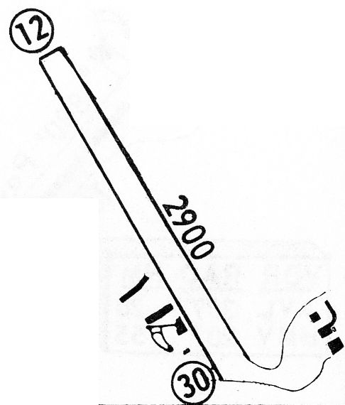
The 1968 Flight Guide (courtesy of Bob Levittan) depicted Brockenbrough Airport as having a 2,900' unpaved Runway 12/30,
with several small buildings on the southwest & southeast sides.
A 1968 aerial photo showed that a racetrack & several buildings had been built at some point between 1965-68 over the northeast/southwest runway.
The northwest/southeast runway & the hangars remained intact, but there were no aircraft visible on the field.
The primary runway at Brockenbrough had been paved at some point between 1968-72,
as the August 1972 Charlotte Sectional Chart (courtesy of Robert Brown)
depicted the field as having a 2,900' paved runway, oriented northwest/southeast.
A 1978 aerial photo showed that 5 single-engine aircraft were visible on the south side of the field.
The cluster of 6 individual T-hangars had been removed at some point between 1968-78.
Michael Payne recalled, “I learned to fly & soloed at Brockenborough in the late 1970s & early 1980s.
I also worked for Jerry & Ted Archer there. They ran the Metrolina Flying Club.
The full length runway & taxiway were both paved. I later worked in the airlines with one of the guys that lived in a trailer on the field when I was there.
One of the last jobs I had there before I left was to tear the taxiway up & seed with grass.
There were a lot of interesting characters there. I helped Kelly (A&P) in the shop, washed & cleaned the planes, fuel, and general FBO duties.
The story around the field was that one of the old A&Ps there developed the STC for the 90hp Cub engine or exhaust manifold.
There were a lot of the old taildraggers at the field owned & flown by 'Good Ole Boys'.”
The 1982 AOPA Airport Directory (courtesy of Ed Drury) described Brockenbrough
as having a 2,391' asphalt Runway 14/32.
The unpaved crosswind runway had apparently been closed at some point between 1965-82.
According to Charles Phillips, Jerry Keller was the last operator at "Brock".
He later moved to the Metrolina Flying Club at Willgrove (8A6) in Charlotte.
Charles recalled, “Brockenbrough was closed when the owner Horace Wells died.
His niece closed the airport in August 1986.
I was running the maintenance shop at the time.
I also worked at Eastern airlines. I was evicted on Tuesday & laid off at Eastern on Thursday of the same week.
Just like the Space Shuttle blowing up and the Twin Towers falling you remember dates that will never forget.
The airport was closed to make room for parking at the Metrolina flea market.
I was told to haul the planes out that I was working on.
Instead I flew them out using the driveway leading into the flea market just as the sun showed first light.”
Brockenbrough Airport was still depicted on the 1996 USGS topo map,
even though it had been closed for 10 years by that point.
Brockenbrough Airport was no longer depicted at all (even as an abandoned airport) on the 1998 World Aeronautical Chart.
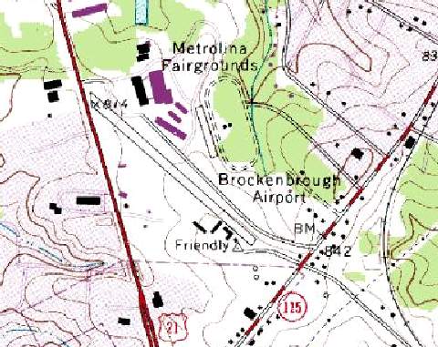
A circa 2006 aerial view looking north at the site of Brockenbrough Airport
showed the paved runway which remains intact, on the south side of the racetrack
An 8/214/09 aerial view looking northwest showed the majority of the former Brockenbrough runway still remained,
and was being used as a road for adjacent automobile parking areas.
The site of Brockenbrough Airport is located west of the intersection of Old Statesville Road & Apache Avenue.
____________________________________________________
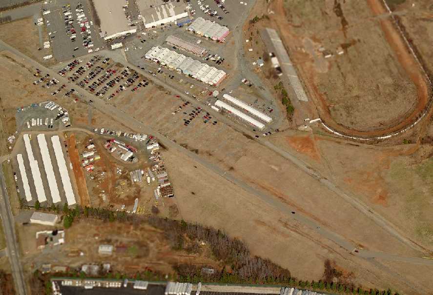
North Wilkesboro Airport, North Wilkesboro, NC
36.15, -81.16 (West of Greensboro, NC)
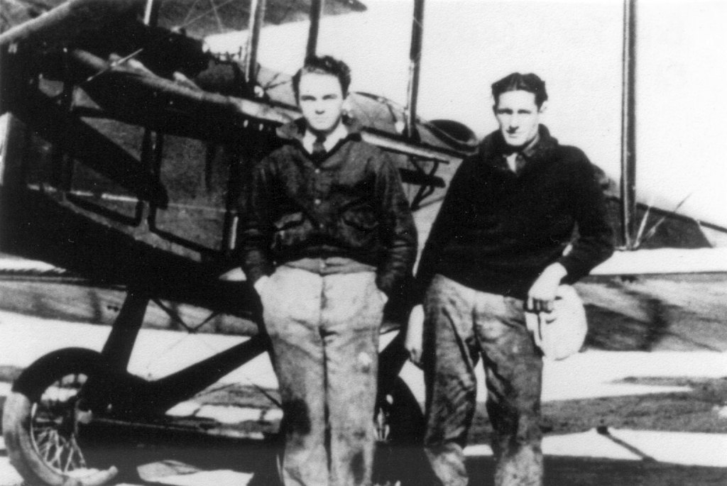
A 1932 photo by William S. Ford of William “Billy” Ford & Ed Newkirk standing in front of Ford’s Curtiss JN-4 Jenny at North Wilkesboro Airport (courtesy of Dave Ford).
The date of construction of this municipal airport has not been determined.
Dave Ford reported, “I have located the airfield where my father (William 'Billy' Ford) flew his first airplane in 1925 in North Wilkesboro.
When he was a young boy he acquired a Jenny & refurbished it at the field in North Wilkesboro.
He & his friend Ed Newkirk were considered local aviation pioneers & barnstormers.
He was 18 years old when he took off in the Jenny at the North Wilkesboro field.
Through the years the family has referred to the field as 'The cornfield', which it may have been in 1925.”
The earliest depiction of North Wilkesboro Airport which has been located
was a 1932 photo of William “Billy” Ford & Ed Newkirk standing in front of Ford’s Curtiss JN-4 Jenny (courtesy of Dave Ford).
The earliest directory listing of North Wilkesboro Airport which has been located
was in The Airport Directory Company's 1933 Airports Directory (courtesy of Chris Kennedy).
It described North Wilkesboro as a commercial airport, measuring 6 acres in size.
The turf field was said to be oblong in shape, and to measure 1,200' x 300'.
The field was said to have a hangar.
The earliest aeronautical chart depiction of North Wilkesboro Airport which has been located
was on the 1935 Winston-Salem Airway Chart.
It depicted North Wilkesboro as a commercial or municipal airport.
The Airport Directory Company's 1937 Airports Directory (courtesy of Bob Rambo)
described North Wilkesboro Airport as having a 1,500' east/west turf runway & a hangar.
North Wilkesboro Airport was listed among active airfields
in The Airport Directory Company's 1938 Airports Directory (according to Chris Kennedy).
The North Wilkesboro Airport was evidently temporarily closed at some point between 1938-41
(like many other small civilian airports, due to wartime security concerns),
as it was not listed among active airports in The Airport Directory Company's 1941 Airports Directory (according to Chris Kennedy)
nor depicted on the 1945 Winston-Salem Sectional Chart (courtesy of Chris Kennedy).
The airport apparently reopened at some point between 1945-48,
as the 1948 Winston-Salem Sectional Chart (courtesy of Chris Kennedy)
depicted "North Wilkesboro" Airport as having a 1,500' unpaved runway.
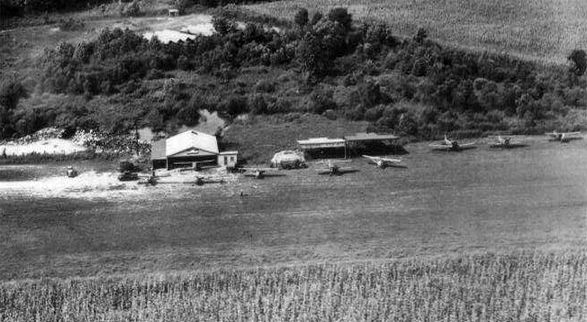
The last photo which has been located of the North Wilkesboro Airport was a circa 1950s aerial view looking north (courtesy of Sherman Aaron),
which depicted 8 single-engine aircraft & some hangars alongside a grass runway.
Sherman Aaron noted, “The hill to the back left center of photo is where the present-day Wilkes Regional Medical center is built.”
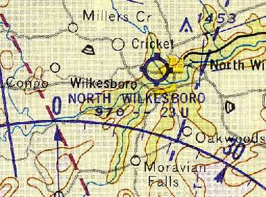
North Wilkesboro Airport, as depicted on the July 1961 Winston-Salem Sectional Chart (courtesy of Chris Kennedy).
North Wilkesboro Airport was listed among active airports in the 1962 AOPA Airport Directory,
with a 2,300' turf runway, and the operator listed as Woodruff R. Wallace.
At some point between 1962-63, the North Wilkesboro Airport was evidently replaced
by the new Wilkes County Airport (1 mile to the southwest), which had a paved runway,
as the North Wilkesboro Airport was no longer listed in the 1963 AOPA Airport Directory (according to Chris Kennedy).
The April 1964 Winston-Salem Sectional Chart (courtesy of Chris Kennedy) depicted the new Wilkes County Airport,
but not the original North Wilkesboro Airport.
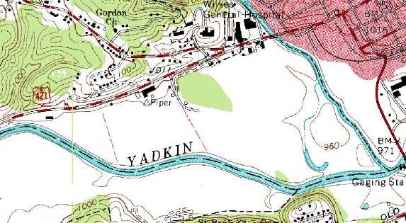
The 1966 USGS topo map did not depict the original North Wilkesboro Airport.
Interestingly, though, it did still depict a survey marker named "Piper"
at the site of the original North Wilkesboro Airport.
A building was immediately adjacent to the survey marker -
it is not known if this was an airfield building (a hangar?).
As seen in the 1998 USGS aerial photo, several buildings had been built along the western portion
of the site of the original North Wilkesboro Airport.
It did not appear as if any original airfield buildings remained.
The eastern portion of the airfield remained an open field.
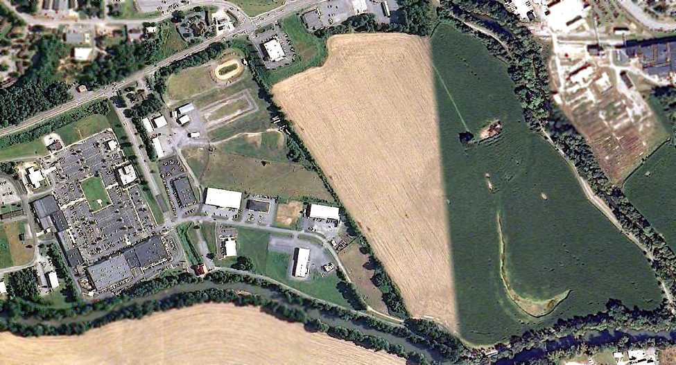
A 5/31/09 aerial photo showed the site of the original North Wilkesboro Airport to remain in the same condition -
with no recognizable traces of the former airport.
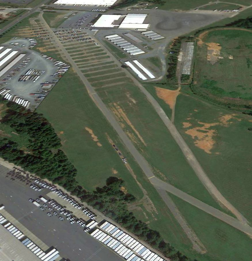
A 2016 photo looking southeast at the site of the original North Wilkesboro Airport (courtesy of Dave Ford).
Dave's cousin Bill reported that “The area that was the airport was a long field which is now a medical professional plaza.
They've filled in a ramp road from the low-lying field up to the 421 business route that runs through North Wilkesboro.”
The site of the original North Wilkesboro Airport is located
south of the intersection of Business Route 421 & West Park Lane.
____________________________________________________
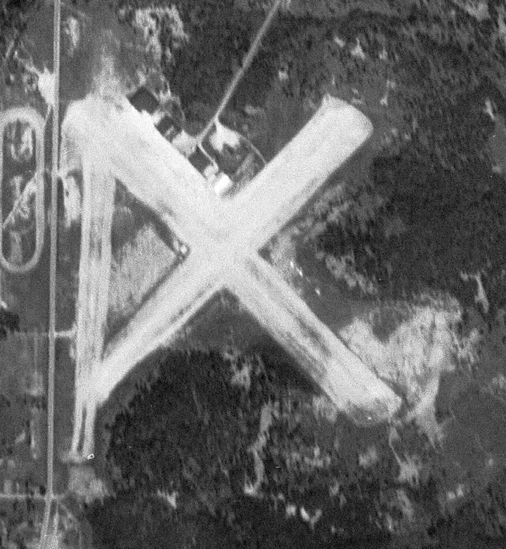
(Original) Wilkes County Airport (IKB), Wilkesboro, NC
36.14, -81.19 (West of Greensboro, NC)
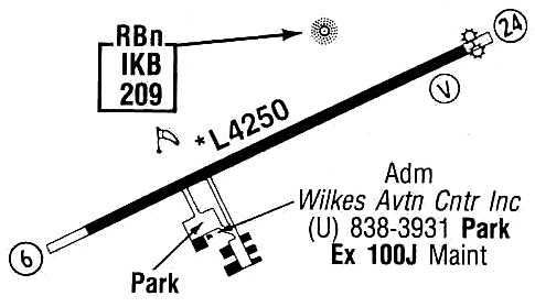
Wilkes County Airport, as depicted on the April 1964 Winston-Salem Sectional Chart (courtesy of Chris Kennedy).
Photo of the airport while open has not been located.
At some point between 1962-63, the North Wilkesboro Airport (1 mile to the northeast)
was evidently replaced by the new Wilkes County Airport.
The earliest reference to the Wilkes County Airport at this location which has been located
was on the April 1964 Winston-Salem Sectional Chart (courtesy of Chris Kennedy).
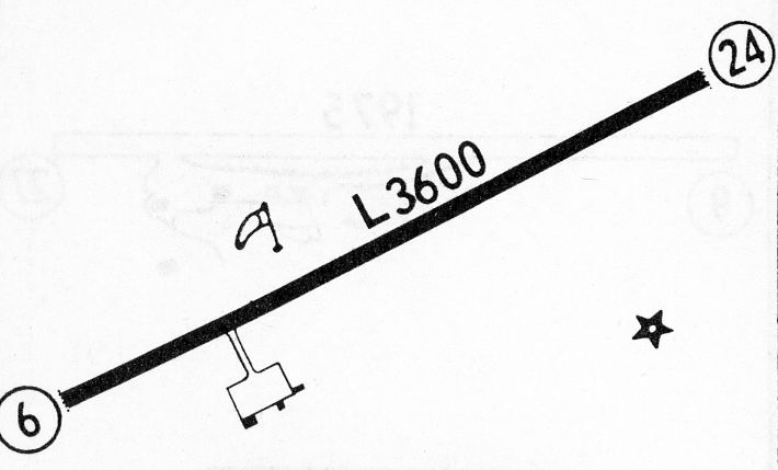
It depicted the new Wilkes County Airport as having a 3,600' hard-surface runway.
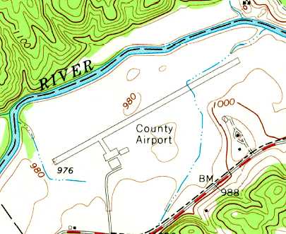
The 1966 USGS topo map depicted Wilkes County Airport as having a single northeast/southwest paved runway with a ramp & 2 buildings on the south side.
The 1968 Flight Guide (courtesy of Bob Levittan)
depicted Wilkes County Airport as having a single 3,600' paved Runway 6/26,
and a ramp on the south side of the runway with 3 buildings (hangars?).
The 1971 Flight Guide (according to Chris Kennedy)
described the Wilkes County Airport as having a 3,600' paved Runway 6/24.
The runway was lengthened somewhat within the next few years,
as the 1982 AOPA Airport Directory (courtesy of Ed Drury) described Wilkes County Airport
as having a 4,250' paved Runway 6/24, and listed the operator as Wilkes Aviation Center Inc.
The 1987 Flight Guide (courtesy of Chris Kennedy)
depicted Wilkes County Airport as having a single 4,250' paved Runway 6/26,
and a ramp on the south side of the runway with 6 buildings (hangars?).
The operator was listed as Wilkes Aviation Center, Inc.
The original Wilkes County Airport was closed at an unknown date (between 1987-90),
when it was replaced by a newer & larger Wilkes County Airport to the Northeast.
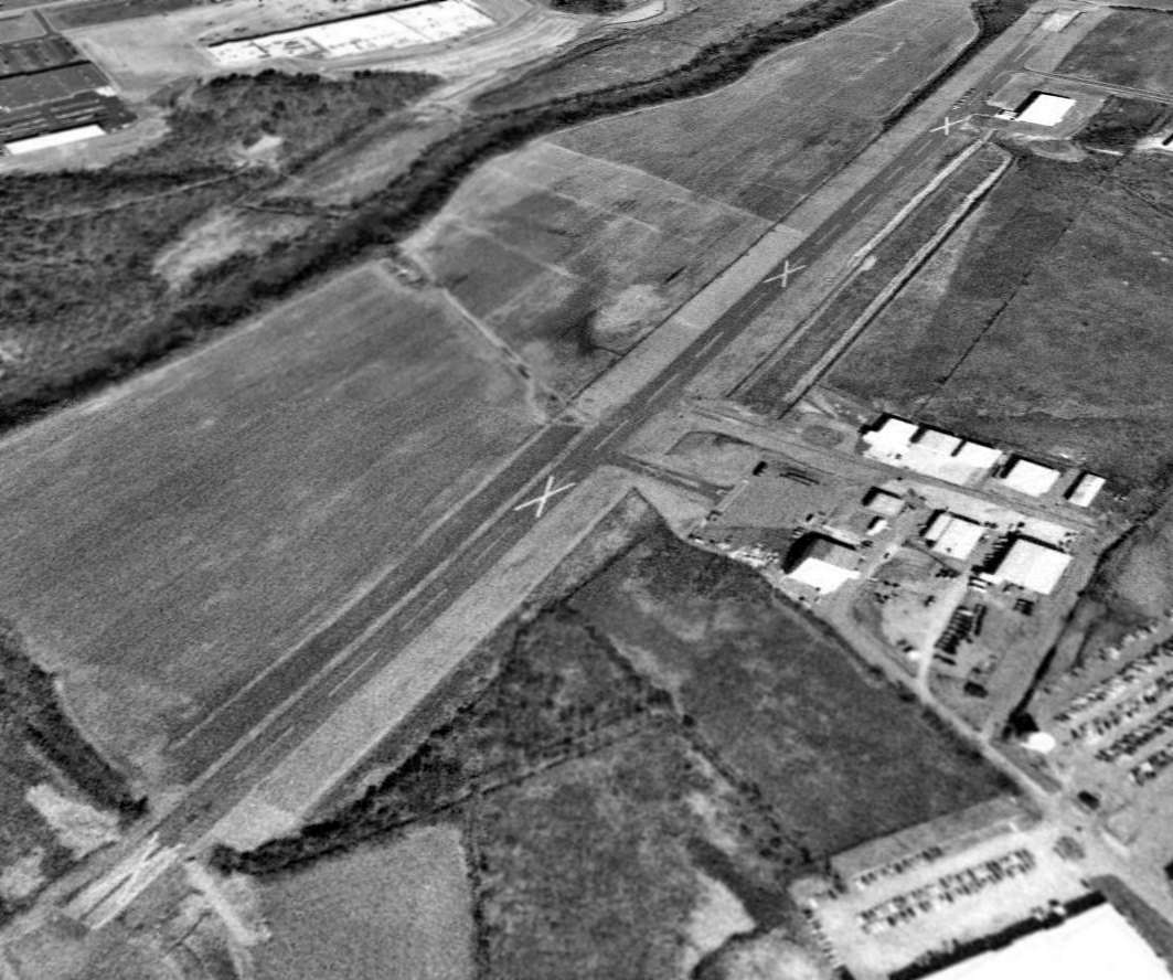
As of the 1993 USGS aerial view looking northeast (taken after the field's closure),
the The original Wilkes County Airport remained completely intact & unredeveloped.
The paved runway was marked with 3 closed-runway “X” symbols,
and all of the hangars remained standing.
Jon Guza reported in 2003 that the former airport has been used for the past few years as
"a gigantic parking lot during MerleFest every April.
MF is a 4-day bluegrass festival that gets bigger every year (last year was around 70,000 people I think).
We parked right along an old runway with tons of other cars."
Larry Reeves reported in 2007, “The former Wilkes County Airport runway
remains fully intact & serves as a road used to access Rivers Edge Park
which has radio-controlled flying, skateboard park, soccer fields, etc. on one side, and on the other an industrial park.
Nothing was really changed when it was decommissioned, things just cropped up around it.”
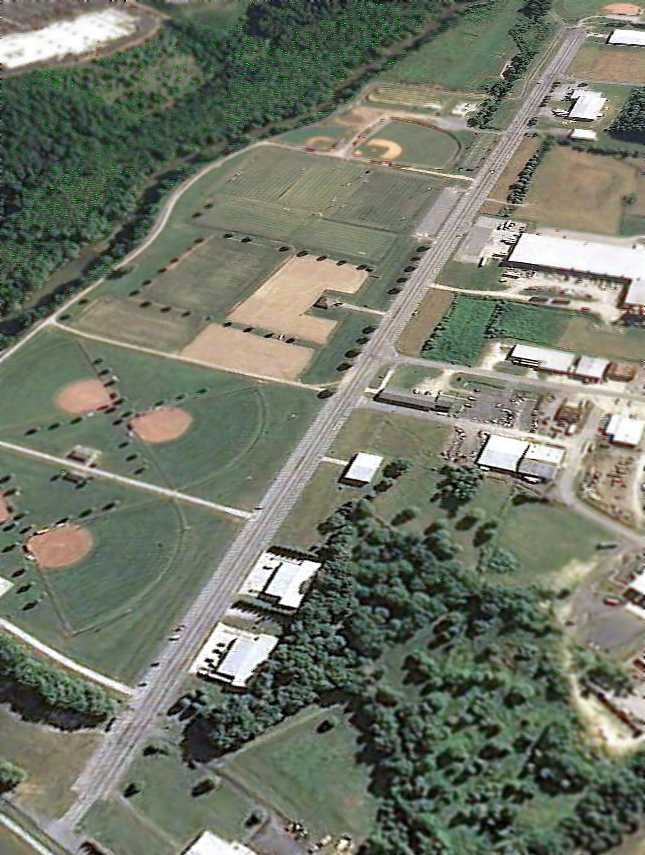
A 5/31/09 aerial view looking northeast showed that the runway & hangars remained,
but several new buildings had been constructed adjacent to the south side of the former runway,
and the area to the north had been redeveloped as ballfields.
The original Wilkes County Airport is located at the end of Stokes Street, northwest of Route 268.
____________________________________________________
Since this site was first put on the web in 1999, its popularity has grown tremendously.
That has caused it to often exceed bandwidth limitations
set by the company which I pay to host it on the web.
If the total quantity of material on this site is to continue to grow,
it will require ever-increasing funding to pay its expenses.
Therefore, I request financial contributions from site visitors,
to help defray the increasing costs of the site
and ensure that it continues to be available & to grow.
What would you pay for a good aviation magazine, or a good aviation book?
Please consider a donation of an equivalent amount, at the least.
This site is not supported by commercial advertising –
it is purely supported by donations.
If you enjoy the site, and would like to make a financial contribution,
you
may use a credit card via
![]() ,
using one of 2 methods:
,
using one of 2 methods:
To make a one-time donation of an amount of your choice:
Or you can sign up for a $10 monthly subscription to help support the site on an ongoing basis:
Or if you prefer to contact me directly concerning a contribution (for a mailing address to send a check),
please contact me at: paulandterryfreeman@gmail.com
If you enjoy this web site, please support it with a financial contribution.
please contact me at: paulandterryfreeman@gmail.com
If you enjoy this web site, please support it with a financial contribution.
____________________________________________________
This site covers airfields in all 50 states.