Abandoned & Little-Known Airfields:
Southern Maryland
© 2002, © 2016 by Paul Freeman. Revised 12/11/16.
This site covers airfields in all 50 states: Click here for the site's main menu.
____________________________________________________
Please consider a financial contribution to support the continued growth & operation of this site.
Aqualand Airport (revised 7/8/15) - Half Pone Point Airport (added 11/1/13) - La Plata Airfield (revised 11/17/06)
Lower Marlboro Airport (added 12/11/16) - Park Hall Airport (revised 7/8/15) - Piney Point Airport (revised 7/8/15)
____________________________________________________
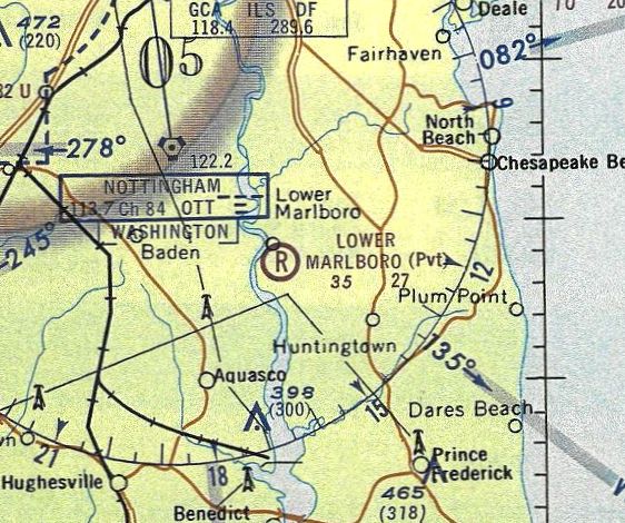
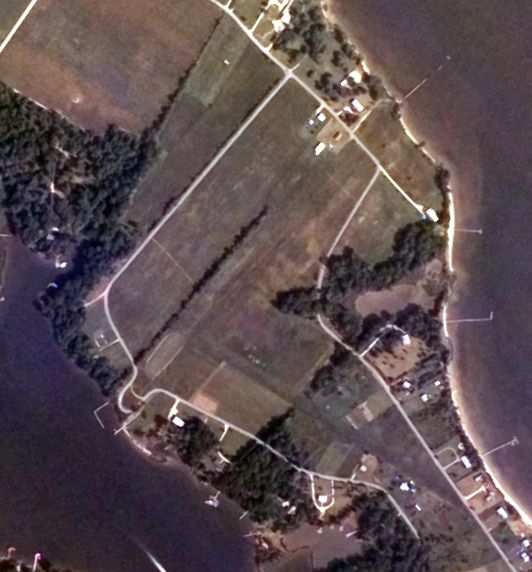
Lower Marlboro Airport, Lower Marlboro, MD
38.652, -76.679 (Southeast of Washington, DC)
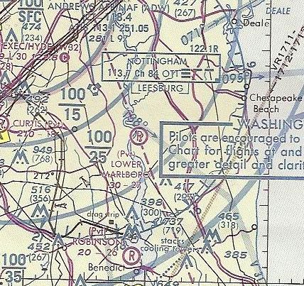
Park Hall Airport, as depicted on the 1964 Washington Sectional Chart.
This small private airfield southeast of Washington DC was evidently established at some point between 1964-71,
as it was not yet depicted on the 1964 Washington Sectional Chart.
The earliest depiction which has been located of Lower Marlboro Airport was on the 1971 Washington Sectional Chart.
It depicted Lower Marlboro as a private airfield having a 2,700' unpaved runway.
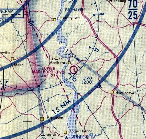
The 1975 Washington Terminal Aeronautical Chart
depicted Lower Marlboro as a private airfield having a 2,700' unpaved runway.
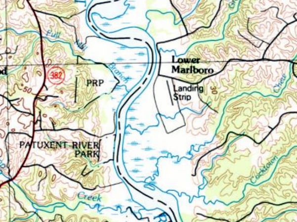
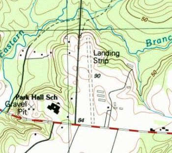
The earliest topo map depiction which has been located of Lower Marlboro Airport was on the 1983 USGS topo map.
It depicted Lower Marlboro as having a northwest/southeast runway, labeled simply as “Landing Strip”.
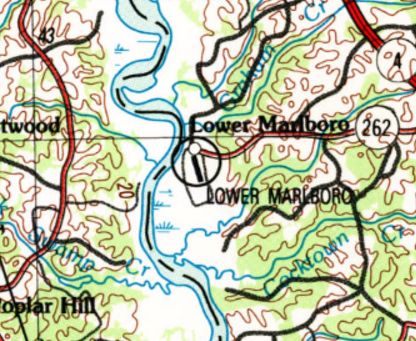
Lower Marlboro Airport, as depicted on the 1989 USGS topo map.
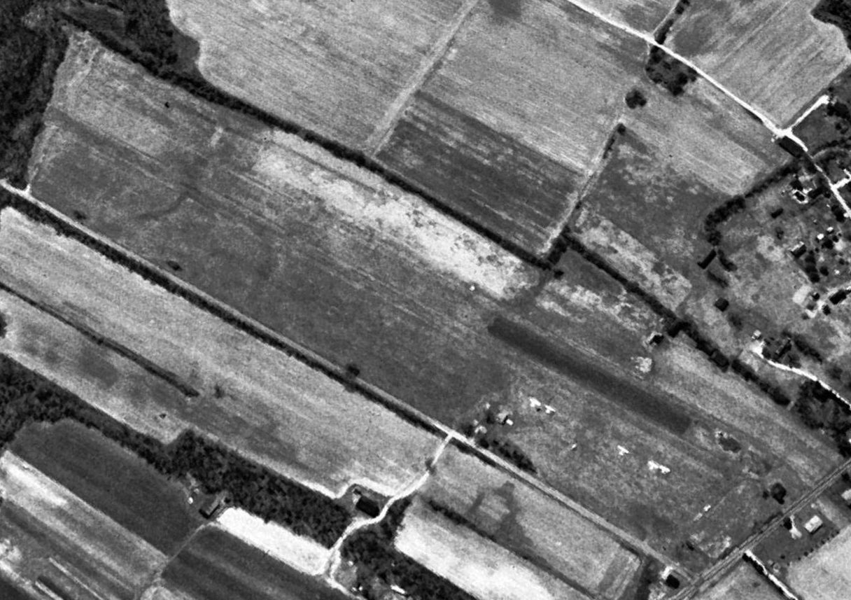
The earliest photo which has been located of Lower Marlboro Airport was a 1993 USGS aerial view looking southeast.
It depicted Lower Marlboro as having a single northwest/southeast grass runway,
and 5 light single-engine planes were visible parked on the northeast side.
The last aeronautical depiction which has been located of Lower Marlboro Airport was on the 1993 Washington Sectional Chart.
It depicted Lower Marlboro as a private airfield having a 2,700' unpaved runway.
Lower Marlboro Airport was evidently closed at some point between 1993-2004.
It suffered the same fate as so many small grassroots airports across the US,
as a 2004 aerial photo showed houses having been built along the former runway.
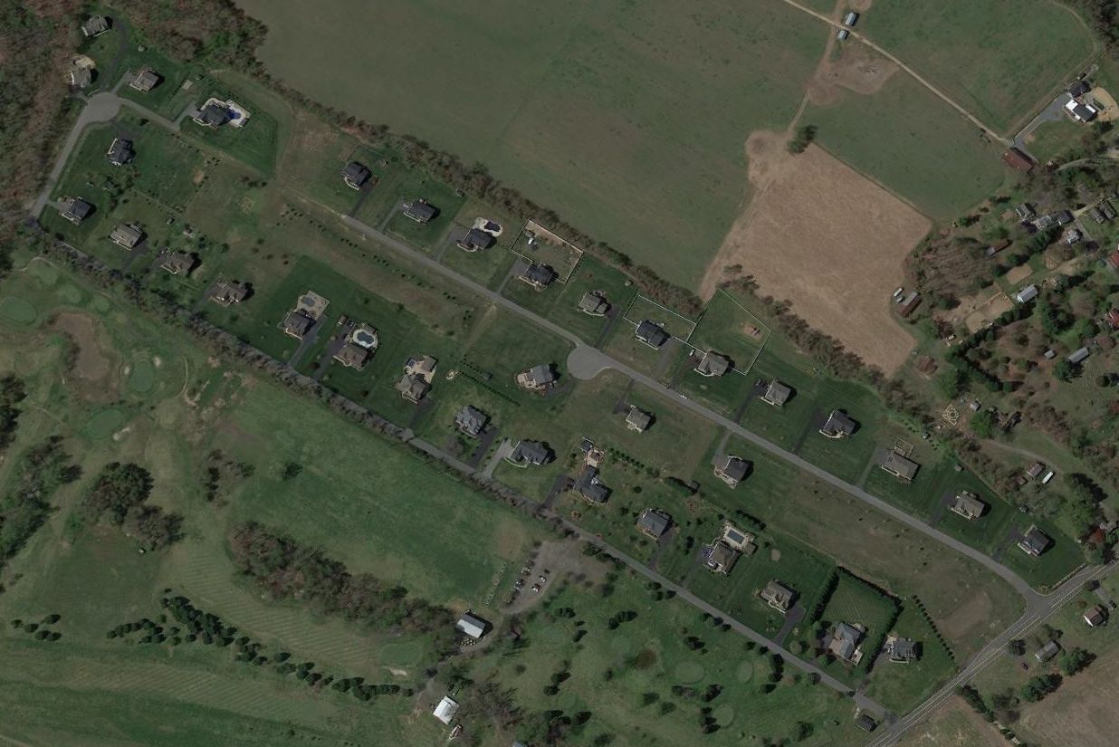
A 2016 aerial view looking southeast showed no trace remaining of Lower Marlboro Airport.
The site of Lower Marlboro Airport is located at Old Airpark Lane, appropriately enough.
____________________________________________________
Park Hall Airport, Lexington Park, MD
38.23, -76.45 (Southeast of Washington, DC)
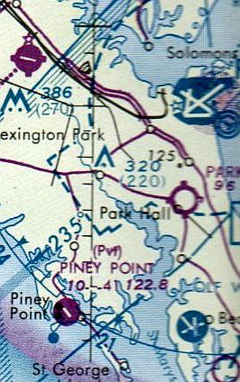
Park Hall Airport, as depicted on the 1964 Washington Sectional Chart.
According to Bob Belvins, “Park Hall Airport was a grass field.
It was started by Mr. Dixon about 1945 who owned the field & learned to fly at his field.
Others then wanted to park their planes there, thus he expanded into a local air field.
It had right-hand approaches so not to scare the cows & chickens in the adjacent field.
It had 3 rows of covered sheds for aircraft with about 10 aircraft outside on the grass,
and in the early 1960s it housed the St Mary's County Civil Air Patrol Squadron.”
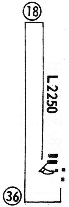
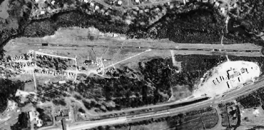
The earliest depiction which has been located of Park Hall Airport was on the 1964 Washington Sectional Chart.
Paul Dziewit recalled, “Park Hall... When I was a kid I used to fly out of there with my dad all the time.
The airfield was all grass & at the end of the runway the power lines actually came down from the poles, went underground, then back up again.
It was always quite a visual to see an old J3 Cub take off & a large truck go down the road at the same time.”
The only airport directory listing which has been located of Park Hall Airport was in the 1968 Flight Guide (courtesy of Robert Levittan).
It depicted Park Hall as having a single 2,250' unpaved Runway 18/36, with 5 small buildings on the southeast side.
The last aeronautical chart depiction which has been located of Park Hall Airport was on the 1976 Washington Sectional Chart.
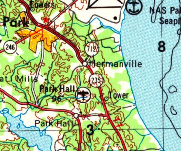
Park Hall Airport, as depicted on the 1979 USGS topo map.
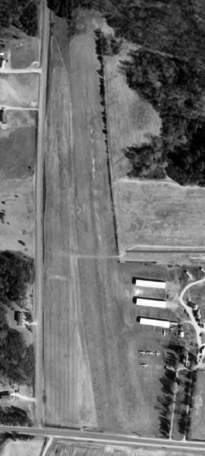
The only photo which has been located of Park Hall Airport was a 3/1/81 USGS aerial view.
It depicted Park Hall as having a single north/south grass runway,
with 3 rows of hangars & 4 single-engine aircraft on the southeast side.
John Pleisse recalled, “Park Hall Airport... I solo’ed there at age 16 [1981].
[It] was really the vibrancy of St Mary’s County general aviation.
It closed in the mid-1980s.”
The last depiction which has been located of Park Hall Airport was on the 1987 USGS topo map.
It depicted Park Hall as having a single north/south unpaved runway, labeled simply as “Landing Strip”,
with 3 rows of hangars on the southeast side.
A 1993 USGS aerial photo appeared to show no trace of the former airport,
with houses having been built on the property.
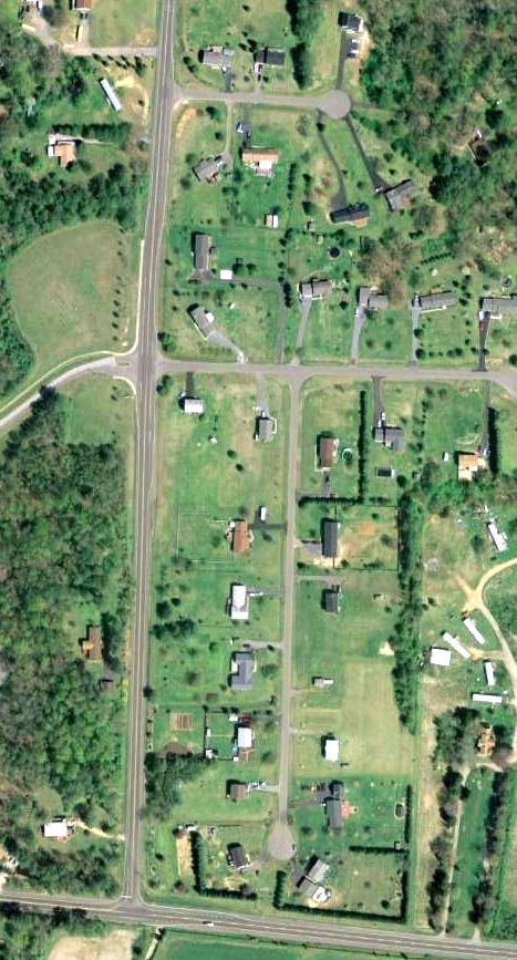
A 3/29/07 aerial photo showed no trace remaining of Park Hall Airport.
Bob Blevins reported in 2013, “Park Hall Airport is now a housing development with the grass runway being the main street of the development.”
The site of Park Hall Airport is commemorated via the names of the streets which were built upon the site:
Spitfire Court & Piper Court.
____________________________________________________
Half Pone Point Airport, Hollywood, MD
38.35, -76.5 (Southeast of Washington, DC)
A 3/22/51 aerial view of Half Pone Point Airport (courtesy of Bob Blevins).
According to Bob Belvins, “Half Pone Point Field was in use from about 1947-49.
It was started by the local farmer who owned the field.”
The earliest depiction which has been located of Half Pone Point Airport was a 3/22/51 aerial view (courtesy of Bob Blevins).
It depicted Half Pone Point as having 2 grass runways with a few small buildings on the northeast side.
The earliest aeronautical chart depiction which has been located of Half Pone Point Airport
was on the 1951 Washington Sectional Chart (courtesy of Mike Keefe).
It described Half Pone Point as a commercial airport having 2 runways, with the longest measuring 2,400'.
The only photo which has been located showing aircraft at Half Pone Point Airport was a 3/27/52 USGS aerial view.
It depicted one single-engine aircraft next to the hangar on the northeast side.
The last aeronautical chart depiction which has been located of Half Pone Point Airport
was on the 1960 Washington Sectional Chart (courtesy of Mike Keefe).
It described Half Pone Point as having 2 turf runways, with the longest measuring 2,400'.
Half Pone Point Airport was no longer depicted on the 1964 Washington Sectional Chart,
nor was it depicted on USGS topo maps from the 1960s & 1970s.
The last photo which has been located showing Half Pone Point Airport still open was a 9/13/69 USGS aerial view.
Bob Blevins recalled, “Half Pone Point... When I landed there in the early 1970s
only the runway that went across the peninsula was being used & there was one lean-to type hangar at the river end of the runway.”
According to Bob Belvins, “Half Pone Point Field was in use to to approximately 1977 when it was left unmowed to go to be a pine forest.”
A 1993 USGS aerial photo appeared to show no trace of the former hangar.
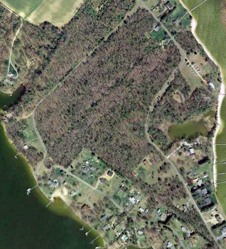
A 3/29/07 aerial photo showed no trace remaining of the Half Pone Point runways, with only the overall property outline still recognizable.
Bob Blevins reported in 2013, “I need to overfly it sometime & took a recent picture – [it is] all trees now.”
The site of Half Pone Point Airport is located south of the intersection of Half Pone Point Road & Steer Horn Neck Road.
____________________________________________________
La Plata Airfield, La Plata, MD
38.54, -76.92 (Southeast of Washington, DC)
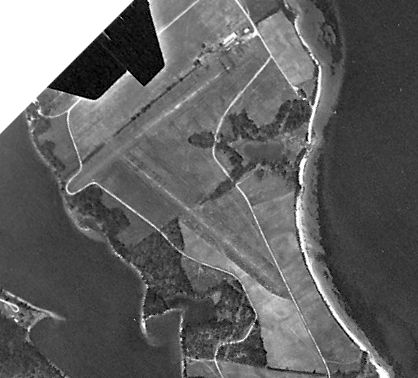
A 1993 USGS aerial view looking southwest at the airfield in La Plata.
According to Rick Ringer, “This airfield is located off Route 488 in LaPlata in a neighborhood called Kerrick Manor.
It is/was owned by Tom Posey who was a prominent lawyer. He owned a farm where he built a grass airstrip.
He owned a Piper (140 or 180) that he used to fly occasionally.
There is a small barn located on the property where the airstrip is located, but I don't believe it was large enough to house the aircraft.
My wife's family used to live in Kerrick Manor when we were dating. The Posey family were friends of my family.
Everyone used to envy the fact that he had his own aircraft & landing strip. He used to fly quite a bit in the 1970s & 1980s.
I'd imagine that age pretty much contributed to the decrease in activity.”
The 1993 USGS aerial photo shows what appears to be a single 2,200' paved east/west runway,
with a small paved ramp on the south side of the middle of the runway, with a single small hangar.
No airfield was depicted in this location on recent USGS topo maps or aeronautical charts,
and no airfield was listed in this location in FAA records, as of 2005.
Jim Kushner reported in 2006, “I actually saw an aircraft take off from the La Plata Airport.
It was a couple of years ago when I was driving down La Plata Road.
I was a little surprised to see a plane pop up over the trees from that location.
From the road it pretty much looks like a farm field surrounded by trees.
I'm also a pilot myself so I was intrigued by his clearance over the trees & other obstacles in the area.”
Rick Ringer reported in 2012, “Posey subdivided the property & sold off lots to individuals who built larger homes & created the development called Kerrick Manor.”
I went by there back in September 2011 & the aircraft was gone & the grass in the field was rather high. I doubt that it is operational anymore.
It also was not perfectly flat, but had a bit of an arch longitudinally.
The topography of the land was such that it fell off considerably at the end of the airfield closest to LaPlata.”
In a 2012 aerial view looking southwest, the runway at La Plata appeared to be unpaved (compared to its appearance in the 1993 aerial photo).
The La Plata Airfield is located on the south side of La Plata Road, at its intersection with Cool Springs Farm Place,
3 miles east of La Plata, MD.
____________________________________________________
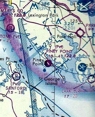
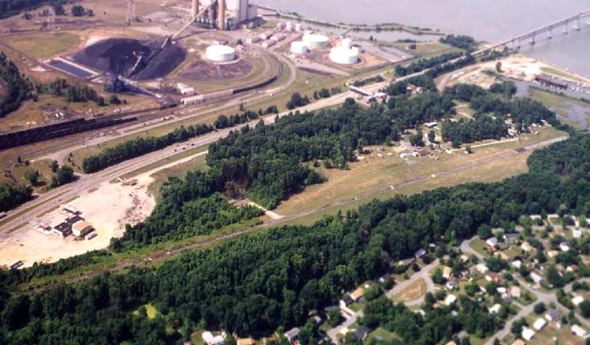
Piney Point Airport (MD96), Piney Point, MD
38.15, -76.52 (Southwest of Patuxent River NAS, MD)
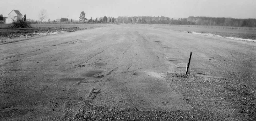
A 1/21/42 National Archives photo looking north along the Piney Point runway,
under construction by the Diamond Construction Company, for the “Emergency landing field for torpedo chasing planes” (courtesy of Michael Smolek).
According to Al Peters, Piney Point was built during WW2
as one of at least 2 torpedo testing stations in the area around Patuxent River NAS.
The WW2 military facilities at Piney Point included a paved airfield,
which was presumably used to support the torpedo testing operations.
The earliest depiction which has been located of the Piney Point airfield
was a 1/21/42 National Archives photo looking north along the Piney Point runway,
under construction by the Diamond Construction Company, for the “Emergency landing field for torpedo chasing planes” (courtesy of Michael Smolek).
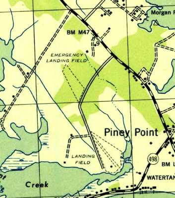
Curiously, the 1943 USGS topo map depicted 2 airfields at Piney Point:
the outline of an “Emergency Landing Field” to the northwest,
and a “Landing Field” with a single unpaved northwest/southeast runway & a single small building to the southeast.
The Piney Point airfield was not yet depicted on the May 1944 Regional Aeronautical Chart (courtesy of Chris Kennedy).
The earliest aeronautical chart depiction of the airfield which has been located
was on the November 1944 Regional Aeronautical Chart (courtesy of Chris Kennedy),
which labeled it as "Piney Point (Navy)".
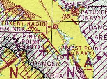
"Piney Point (Navy)" was still depicted on the 1945 Washington Sectional Chart (courtesy of John Voss)
and the 1946 Washington Sectional Chart (courtesy of Mike Keefe).
“Piney Point (Navy)” was depicted on the 1946 USGS topo map.
After the war the property was broken up & "given away for practically nothing", in Al's words.
The Steuart Petroleum Company obtained the portion with the airfield,
and constructed a number of petroleum storage tanks on either side of the runway.
Piney Point Airfield was depicted on the 1946 Washington Sectional Chart (courtesy of Mike Keefe)
and the 1947 Washington Sectional Chart, with a 1,400' hard-surfaced runway.
It was depicted on the 1951 Washington Sectional Chart (courtesy of Mike Keefe) with the same configuration,
but as a private airfield.
The 1953 USGS topo map depicted Piney Point in the same configuration as depicted on the 1943 topo map, with 2 airfields:
the outline of an “Emergency Landing Field” to the northwest,
and a “Landing Field” with a single unpaved northwest/southeast runway & a single small building to the southeast.
The January 1954 USAF Washington Sectional Chart (courtesy of Chris Kennedy) depicted Piney Point as a public-use airport,
but the remarks said "No services. Land at own risk."
Piney Point was still depicted as a public-use airport on the January 1956 Washington Sectional Chart (according to Chris Kennedy),
but the field's depiction had changed to that of a private field
on the August 1957 USAF Washington Sectional Chart (according to Chris Kennedy).
However, the Piney Point airfield apparently went through a period of abandonment starting at some point between 1957-60,
as it was labeled "Abandoned airport" on the 1960 & 1961 Washington Sectional Charts (courtesy of Mike Keefe)
and on the February 1962 Washington Sectional Chart (according to Chris Kennedy).
Piney Point was depicted as a civilian airfield on the 1963 USGS topo map.
Piney Point was evidently reopened at some point between 1962-64,
as the 1964 Washington Sectional Chart (courtesy of John Voss) depicted Piney Point as a public-use (not private) airfield,
and the Aerodromes table described it as consisting of a single 3,093' turf & macadam runway.
The 1967 Washington Sectional Chart (courtesy of Mike Keefe) depicted Piney Point in the same manner.
The 1968 USGS topo map depicted Piney Point in a different configuration from what was depicted on the 1953 topo map:
only the “Piney Point Landing Strip” to the southeast was depicted,
and the previously-depicted “Emergency Landing Field” to the northwest was gone.
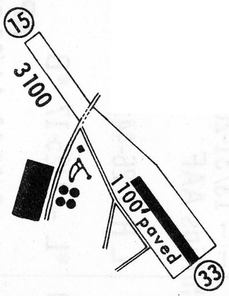
The only airport directory listing which has been located of Piney Point Airfield was in the 1968 Flight Guide (courtesy of Robert Levittan).
It depicted Piney Point as having a 3,100' unpaved Runway 15/33, at the southeast end of which was an 1,100' paved portion.
A single small building & a windsock were adjacent to the west side of the runway,
along with 4 oil storage tanks & a larger building.
By the time of the 1972 Washington Sectional Chart (courtesy of Mike Keefe),
Piney Point was once again depicted as a private airfield.
The 1975 Washington Sectional Chart (courtesy of Ed Drury) depicted Piney Point as a private airfield with a single 4,100' paved runway.
The July 1976 Washington Sectional Chart depicted Piney Point as a private airfield with a single 4,100' paved runway.
Merton Meade recalled, “Dick Watkins flew for Stewart Petroleum at Piney Point.”
The 1980 USGS topo map showed that the Piney Point runway had been lengthened to the northwest
as compared to its depiction on the 1968 topo map, roughly doubling the length of the strip.
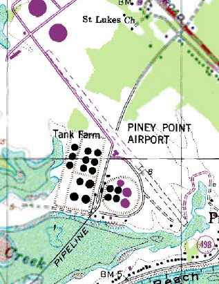
The 1988 USGS topo map depicted the “Piney Point Airport” as having a single runway,
with a single T-hangar along the west side.
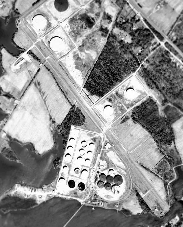
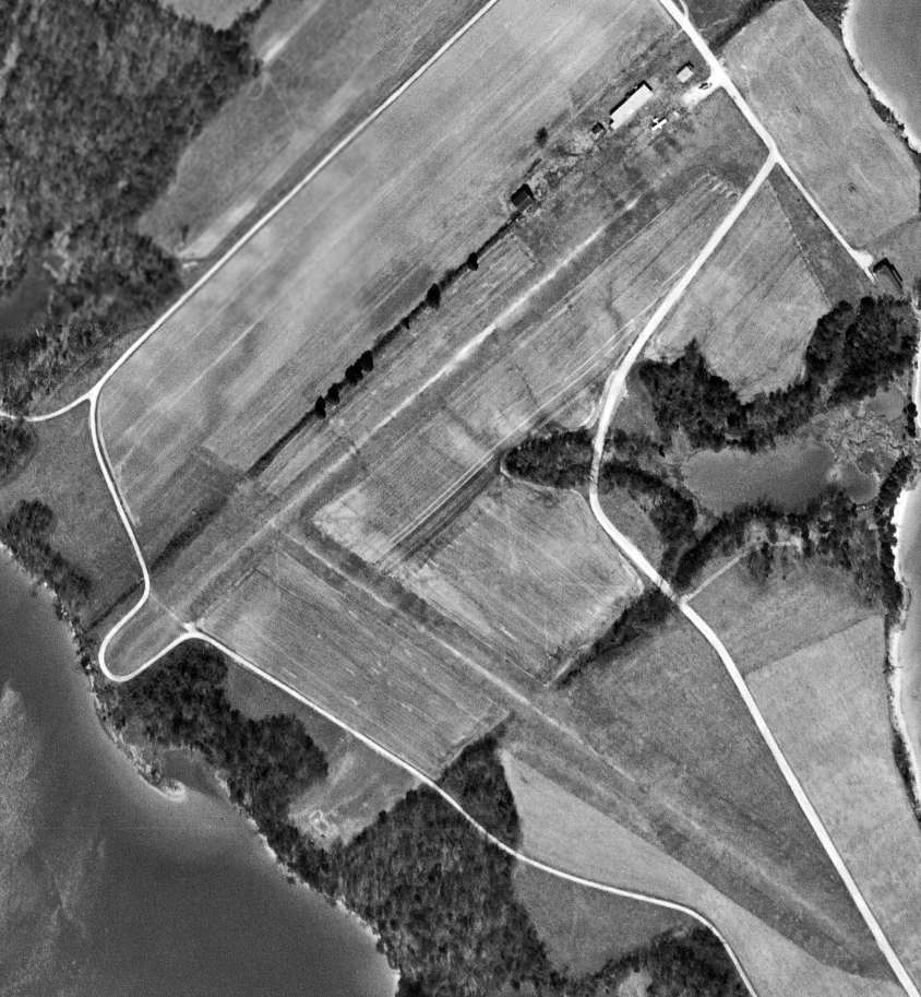
USGS aerial photo 1993.
As of 2002, Steuart Petroleum continued to operate Piney Point Airport as a private airfield.
The airfield consisted of a single 4,100' asphalt Runway 15/33, along with what appeared to be a single hangar,
in between the runway & the tanks on the west side of the airfield.
Paul Freeman visited the Piney Point Airfield in 2002, or at least attempted to.
The Steuart Petroleum property was gated along 2 entrance roads, which prevented any viewing of the airfield.
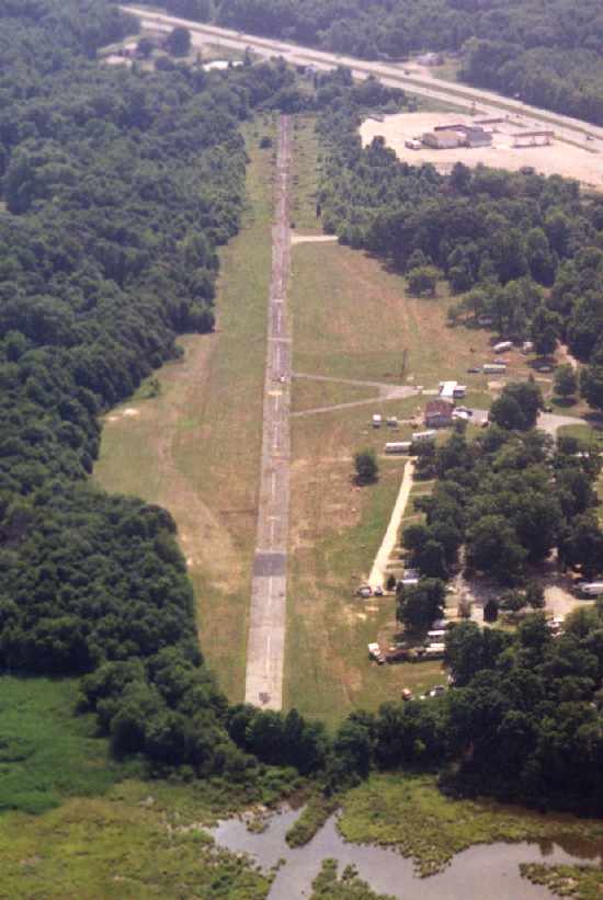
The Piney Point Airfield was evidently closed (for reasons unknown) at some point between 2002-2006,
as it was depicted as an abandoned airfield on the 2006 Washington Sectional Chart (according to Chris Kennedy).
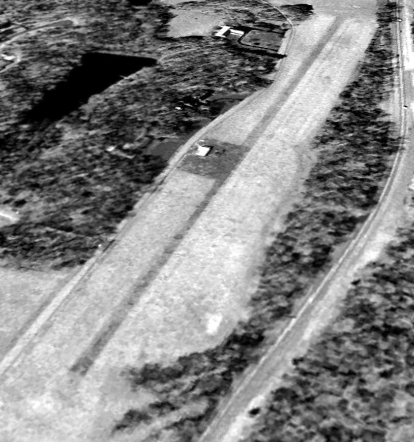
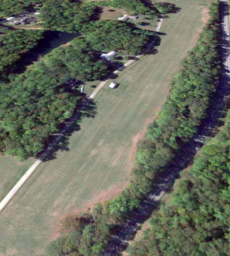
A 3/29/07 aerial view looking northwest along the Piney Point Airport runway showed it to remain in very good condition,
although with several closed-runway “X” symbols painted on it.
The single T-hangar also remained intact along the west side.
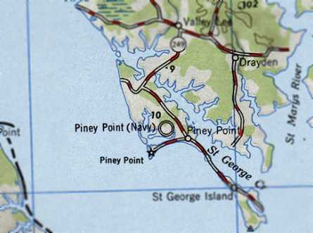
The Piney Point Airport is located south of the intersection of Route 249 & Leahy Drive.
____________________________________________________
38.37, -76.97 (Southeast of Washington, DC)
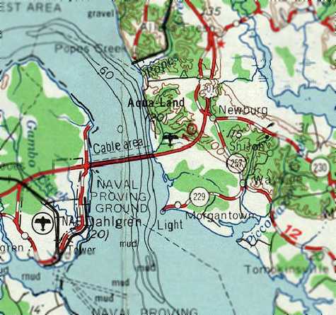
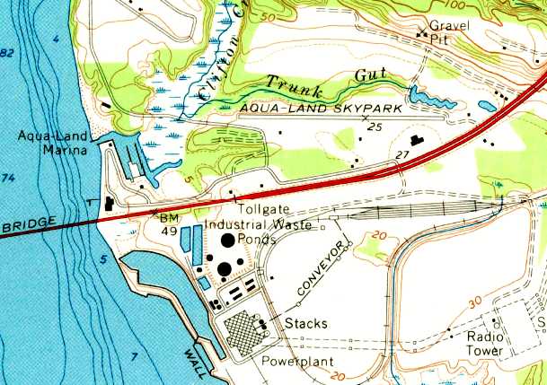
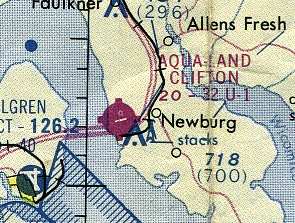
Aqua-Land Airport, as depicted on the 1963 USGS topo map.
This fly-in campground was located along the Maryland shore of the Potomac River,
across the Route 301 bridge from Dahlgren Navy Airfield.
Aqualand Airport was evidently built at some point between 1961-62,
as it was not depicted on a 1952 aerial photo, the 1953 USGS topo map, nor on the 1961 Washington Sectional Chart (courtesy of Mike Keefe).
The earliest reference to Aqualand Airport which has been located was in the 1962 AOPA Airport Directory,
which described the field as having a single 2,700' sod runway,
and listed the operator as Everett Noel.
The earliest depiction which has been located of the Aqualand Airport was on the 1963 USGS topo map.
Rick Ringer recalled, “AquaLand... I used to go there a lot when I was a kid (born in 1963). It was quite a place back in the day.
Denny Connor was quite a visionary & really leveraged the slot machine business to the max. It was an amazing place.
The marina had a lot of gorgeous, larger boats and was successful for quite a while after slot machines left.
They even had a zoo, a train ride & a small amusement park.
I was quite a hangar rat when I was a kid & I used to love to go down there to see the planes come in & out.”
The 1964 Washington Sectional Chart (courtesy of John Voss)
described Aqualand as having a 2,700' unpaved runway.
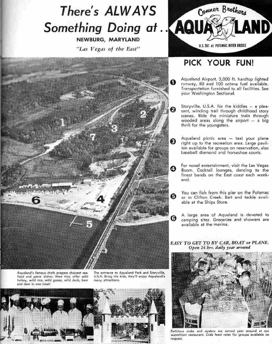
An advertisement for the “Conner Brothers Aqualand” resort,
as published in a 1966 Ohio general aviation magazine (courtesy of Roger Anderson).
It touted the resort as being the “Las Vegas of the East”,
and featured such amenities as a children’s theme park called “Storyville USA”
and a fancy restaurant with 8 chefs & lounge open 24 hours daily, 7 days a week year round,
as well as the marina, campground, and airfield.
The Aqualand airfield had evidently been paved at some point between 1964-66,
as it was described as having a 3,000' hardtop lighted runway, with fuel.
Roger Anderson remarked, “I’ll bet it was a real swinging spot through the late 1960s before the gambling was stopped.
It must have been something of a destination to be advertised full page
in a regional publication intended for an area several hundred miles to the west.
I can imagine landing my Beech Staggerwing & taxing up for dinner in the Vegas Lounge,
then heading out on the Potomac on a 38’ Chris Craft Commander for the weekend.
I think I was born 40 years too late.”
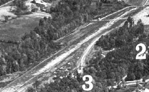
A closeup looking northeast at the Aqualand airfield from the 1966 advertisement (courtesy of Roger Anderson).
Several light planes were visible on the southwest side of the runway.
The 1967 Washington Sectional Chart (courtesy of Mike Keefe)
described Aqua-Land as having a single 2,800' paved runway.
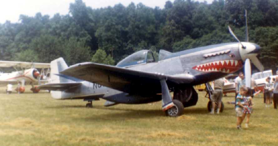
A 6/18/67 photo (by Kenneth Keeton) of a beautiful P-51D Mustang seen at Aqualand's Fathers' Day Airshow.
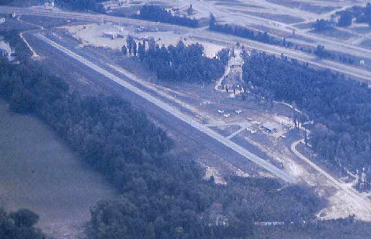
An October 1967 aerial view looking southeast at Aqualand Airport by Chris Kennedy.
Merton Meade recalled, “I remember some good airshows at Aqua Land.
The Taylorcraft group used to land there on Saturday and/or Sunday mornings,
taxi 3 or 4 aeroplanes across the wee bridge & park in the car park to the truck stop... and go in for breakfast.
The ships looked funny parked amongst the 18-wheelers!”
The only airport directory listing which has been located of Aqua-Land Airport was in the 1968 Flight Guide (courtesy of Robert Levittan).
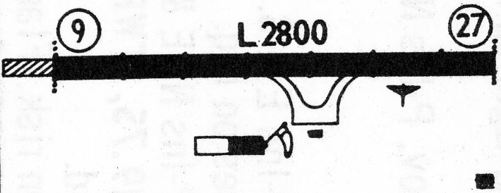
It depicted Aqua-Land as having a single 2,800' paved Runway 9/27, with a ramp & 3 buildings on the southeast side.
Dennis Phillips recalled, "I soloed in a Cessna 150 N6850G out of Aqualand in July of 1971.
Dick [Smith] was one of the owners.
Dick was a retired Air Force pilot & we hangar-flew an imaginary Convair 880 many times. Dick flew one in the Air Force.
One of Dick's partners was Col. Robert Hill, who taught me to fly. Hill was an old B-47 pilot in his early career.
Col. Hill was stationed at Andrews & gave check rides of military Reserve politicians such as Barry Goldwater (he said that was a trip!),
He also flew Saberliners for Air Force transportation flights.
He bought the Cesnna 150 for both pleasure & to use for teaching flying.
Col. Hill had been an Air Force beginning flight instructor at Reese AFB in Lubbock, TX.
The dealership also had a Cessna 172 demo-plane.
About 8-10 other planes were hangared or parked there.
I remember an Aeronca Champ, an Aerocommander, a Navion, and a couple of other planes."
Dennis continued, "To get some extra lessons, I often worked the FBO office, pumped gas & ran the airport on Saturdays & Sundays.
Since it was a long ride back to Bowie I would sleep in the office with Unicom on.
We only had Unicom & no runway lights.
Aqualand was a great place to learn to fly because at that time it was out of all the traffic areas in D.C.
Also those red & white striped powerplant towers could be seen from miles away.
Plus the Potomac River & all the other rivers were great natural landmarks."
Dennis continued, "My understanding was that before 1968 the airport was busy.
The State of Maryland had legal slot machines until Spiro Agnew was elected & closed up the slots.
I was told that the Marina by the water had many high states poker games.
When slots were outlawed the entire Highway 301 gambling industry folded up.
The Reno Diner at the end of the runway barely stayed open & the Marina was hard hit.
After a couple of times I realized that I could not have a greasy burger at the Reno
and then go up & put a Pitts special through the paces."
The earliest topo map depiction which has been located of Aqua Land was on the 1968 USGS topo map,
which labeled the field as “Aqua-Land Skypark”.
According to Mike Skov, "There was at one point (circa 1971-72)
a Cessna dealership there run by a gentleman named Dick Smith.
I believe that he had been a pilot for the 'Special Air Mission' at Andrews AFB,
those being the people who operate the Presidential aircraft.
I bought a Cessna there in 1972.
[Aquland Airport operator] Everett Noel was an FAA designated flight examiner at Manassas Airport
beginning in the late 1960s until at least 1977, perhaps longer."
The 1973 USGS topo map labeled the field as “Aqua-Land Skypark”.
Aqua-Land Clifton Airport, as depicted on the 1975 Washington Sectional Chart (courtesy of Ed Drury).
Rick Ringer recalled, “Back around 1980, they ran a special promotion where they would charge $999 to get you up to your solo including ground school.
My brother did that & I regret that I didn't.
It was a perfect airport to use as a student because of the lack of traffic and the very distinctive landmarks including the bridge, marina, and power plant smoke stacks.”
The 1981 DOD VFR Supplement (courtesy of John Clifford)
and the 1982 AOPA Airport Directory (courtesy of Ed Drury)
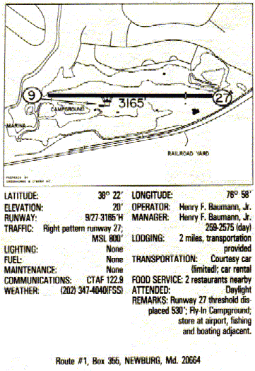
described Aqualand as having a single 3,165' paved Runway 9/27.
Mike Skov recalled, ""The last time I landed there [at Aqualand] was July 4, 1987.
The airport was still open but completely unattended.
At that time I thought the pavement was acceptable but a bit rough. I was in a 182RG."
Greg Wright recalled, “I used to camp there in the early 1980s & I remember the planes there.”
Aqua Land was depicted on a 1987 Maryland State Aeronautical Chart
as having a single 3,165' paved Runway 9/27, with a ramp & a small building on the south side of the strip.
The manager was listed as Henry Baumann.
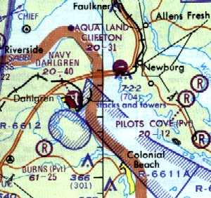
Aqua Land Clifton was still depicted as a public-use airport on the 1987 Maryland State Aeronautical Chart.
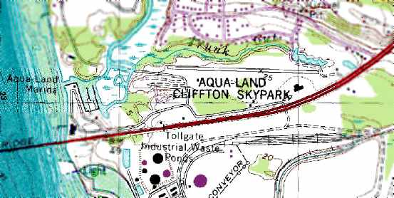
The 1988 USGS topo map depicted the Aqua-Land Clifton Skypark as having a single east/west paved runway.
Aqua-Land was still depicted on the 1991 Washington Sectional Chart (courtesy of Mike Keefe),
but its status had changed to a private airfield.
The end for Aqua-Land Airport apparently came at some point between 1991-93 (for reasons unknown),
as it was depicted as an abandoned airfield on the 1993 MD Aeronautical Chart.
In the 1993 USGS aerial photo, Aqualand was apparently already closed,
as an “X” was visible on the west end of the runway.
A 1999 aerial view by Paul Freeman looking southwest at Aqualand's runway,
taken from a Diamond Katana DA20C-1.
A 1999 aerial view by Paul Freeman looking east along Aqualand's runway,
taken from a Diamond Katana DA20C-1.
The asphalt runway appeared to still remain in very good condition.
According to the book "Maryland Aloft" by Preston, Lanman, and Breilhan,
a Charles County tourism web site indicated in 2002 that the adjacent Aqua-Land Marina was still in operation.
Greg Samonds reported in 2005, “The campsite located right next to the Aqualand runway is very densely populated,
mainly with permanent residents.
The condition has changed greatly since the 1999 aerial photo.
The pavement is in relatively good condition at either end but the middle is a completely different story.
The pavement here is completely broken up & not even visible in some places.
There are even small trees growing through it in places.
Large trees have grown to the very edge of the northern part of the runway
although the concrete remains in relatively good shape.
It amazes me that such large trees were able to grow in only 6 years.
The northern end of the runway has also been vandalized with graffiti.
While I was there I came across a group of local teenagers who had made a fire at the most northern point of the runway.
They said people frequently race dirt bikes down the runway
which would explain the 'start' & 'finish' lines that had been spray painted on the strip.”
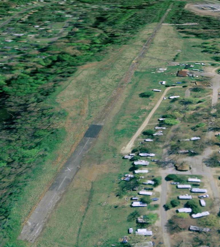
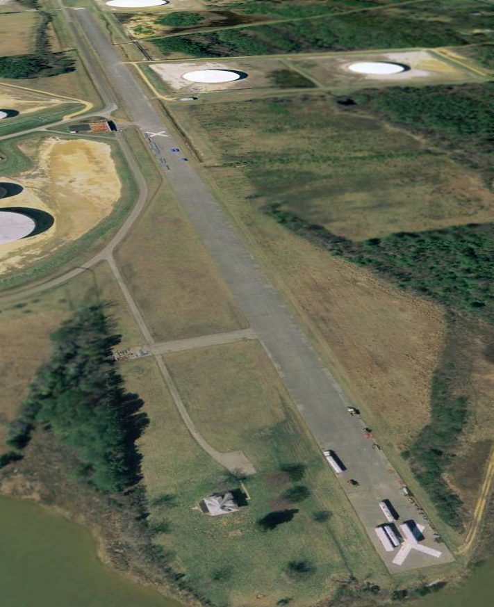
A 2/28/07 aerial photo looking northeast along the former Aqualand runway showed it to remain intact.
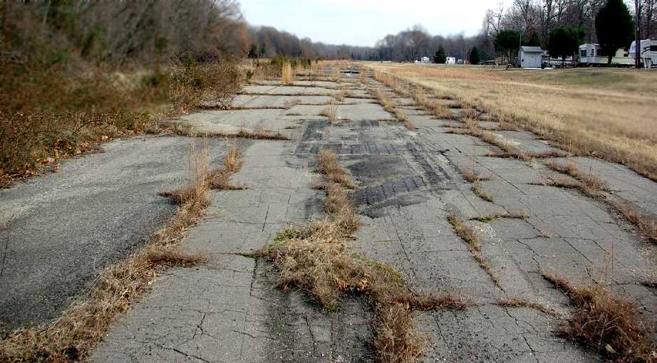
A December 2010 photo by Greg Wright looking east along Aqualand's abandoned Runway 9.
Greg observed, “You can kind of see the runway number & off to the right you can see some of the year-round campers.
The campground is still open & functioning; there were about 10 permanent types of trailers there, but it is obvious that it is very lacking in upkeep.
The very [western] end of the runway has about 75' of actual runway
that you can actually see was the runway & very little plant growth, after that it goes downhill very quickly.
There are small trees & very heavy brush growing, at about the halfway point there is a pretty good size tree growing in the middle of the runway
and from there to the [eastern] end of the runway there are patches of asphalt visible but lots of growth,
the last part of the northern end of the runway is still very much asphalt with a fair amount of growth,
but it narrows to only about 10-12' wide with lots of trees on both sides.
The Google Earth picture from 2007 looks nothing like the current state of the runway.
From ground level you really cannot tell it was ever a runway, even the campground is rundown. What a waste.”
![]()
A December 2010 photo by Greg Wright of a displaced threshold arrow which remains at the end of the former Aqualand's runway.
Rick Ringer reported in 2012, “I went down there recently and was heartbroken that the earth had essentially taken back the ground where the airstrip once stood.
It was heavily grown-over & the old camp ground was far from being as pristine as I had remembered.
There used to be a building where the airport office was & I believe there were one or two other buildings.
I think they had been overgrown or otherwise run-down.”
____________________________________________________
Since this site was first put on the web in 1999, its popularity has grown tremendously.
That has caused it to often exceed bandwidth limitations
set by the company which I pay to host it on the web.
If the total quantity of material on this site is to continue to grow,
it will require ever-increasing funding to pay its expenses.
Therefore, I request financial contributions from site visitors,
to help defray the increasing costs of the site
and ensure that it continues to be available & to grow.
What would you pay for a good aviation magazine, or a good aviation book?
Please consider a donation of an equivalent amount, at the least.
This site is not supported by commercial advertising –
it is purely supported by donations.
If you enjoy the site, and would like to make a financial contribution,
you
may use a credit card via
![]() ,
using one of 2 methods:
,
using one of 2 methods:
To make a one-time donation of an amount of your choice:
Or you can sign up for a $10 monthly subscription to help support the site on an ongoing basis:
Or if you prefer to contact me directly concerning a contribution (for a mailing address to send a check),
please contact me at: paulandterryfreeman@gmail.com
If you enjoy this web site, please support it with a financial contribution.
please contact me at: paulandterryfreeman@gmail.com
If you enjoy this web site, please support it with a financial contribution.
____________________________________________________
This site covers airfields in all 50 states.
For the site's main menu: Home