Hot and wet for
visitors from June through October...
plus seven milder months of frequent and sometimes
mighty winds from the North !
Centro de Prevision del Golfo
de Mexico
Who cares about the weather ?
Weather records are invaluable for the planning and construction of
industrial developments, agriculture, cattle, farming and urban, tourism
and harbor developments as well.
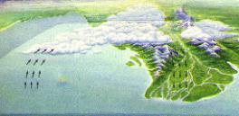 In a world weather
map one can only appreciate the general characteristics of a region but,
when it comes to a region, local weather may vary considerable according
to certain minor topographic characteristics like the slop of a mountain
or the proximity of woods. Depressed portions of land may trap pockets
of cool dense air creating a local phenomenon or as in wooden lands
where vegetation slow winds down creating mild temperatures and increased
humidity.
In a world weather
map one can only appreciate the general characteristics of a region but,
when it comes to a region, local weather may vary considerable according
to certain minor topographic characteristics like the slop of a mountain
or the proximity of woods. Depressed portions of land may trap pockets
of cool dense air creating a local phenomenon or as in wooden lands
where vegetation slow winds down creating mild temperatures and increased
humidity.
Among others, the above mentioned reasons support the establishment
of weather stations in certain regions.
First meteorology station on the continent
The Gulf of Mexico Forecasting Center (Centro de Prevision del Golfo
de Mexico) is one of those and most likely the first meteorology station
on the continent.
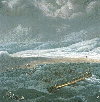 Its increasing
importance paralleled the increase of maritime commerce between Europe
and the "new world". Right after the conquer of Mexico the loss of fragile
vessels had the spaniards to reckon the dangers of the strong winds from
the North that regularly blew over the Gulf of Mexico during fall, winter
and spring. Thus, during the colonial era a meteorology post was
established with what was available at the time in the San Juan de Ulua
island in front of Veracruz, this post served on until 1916.
Its increasing
importance paralleled the increase of maritime commerce between Europe
and the "new world". Right after the conquer of Mexico the loss of fragile
vessels had the spaniards to reckon the dangers of the strong winds from
the North that regularly blew over the Gulf of Mexico during fall, winter
and spring. Thus, during the colonial era a meteorology post was
established with what was available at the time in the San Juan de Ulua
island in front of Veracruz, this post served on until 1916.
From 1790 to 1803, Veracruz Harbor Master Don Bernardo de Orta recorded
valuable data that was to be included later on in a book containing an
investigation of the weather in the "Nueva España" by its author
Baron Alejandro de Humboldt, because he considered those thirteen years
of recorded data, the largest register he found in America.
At the end of 1916, the meteorology station was transfer to an area
in the building of the former lighthouse Venustiano Carranza.
From 1931 and supported by telegraphy, more general information was
gathered and the station started to forecast under the name of "Centro
de Prevision del Golfo" from then on the Center was reckoned by its good
performance mainly due to the man in charge Mr. Ernesto Dominguez Aguirre.
In need of more space, the center was transfer on July 31st,
1952 to the then newly built nautical school "Fernando Siliceo" where it
remained until April 3rd, 1974 when it was moved to its own
premises on the eight floor of the Harbor Services building.
 Weather
forecasting takes experience...
Weather
forecasting takes experience...
the Center acquired prestige probably through the steady and prolonged
direction of several of its men in charge.
| Ing. Daniel Larraga |
1916
|
| Ing. Rafael Lucio |
1917
|
| Ing. Octavio Fernandez de Castro |
1918 to 1921
|
| Ing. Ernesto Dominguez Aguirre |
1922 to 1969
|
| Prof.. Cesar Luna Bauza |
1970 to 1997
|
| LCA Federico Acevedo Rosas |
1997 to date
|
The Center was moved once again in 1992 to a part of what used to be
the Hacienda de Ylang Ylang, near to the Mocambo area in Boca del Rio,
where it is still to date.
To produce its weather forecast three times a day through radio, television
and other media, the Center gathers information mainly as a result of two
of its most important activities:
Meteorology Station:
At this department, meteorology local variables
at ground level are measured and recorded 24 hours a day, among others:
temperature, humidity, atmospheric pressure, rain, evaporation, sun light
and wind speed and direction. |
Sampling of upper atmosphere:
Twice a day, every day, a balloon with instruments
is released to gather information and learn and forecast the stability
conditions of the local atmosphere up to 15 kilometers of altitude above
the Veracruz region. Dew point, temperature, humidity and wind speed and
direction are among the variables recorded. |
Strong winds from the North
The state of Veracruz has two weather seasons, rain and hurricane season
from June to October and "Nortes" (Strong winds from the North) that run
from September to May.
During the rain season, the northern half of the Veracruz State is also
exposed to hurricanes, not so the port of Veracruz located on the southern
half of the state, where very few hurricanes have hit the harbor in this
century. North winds however, originating in the Arctic, swept down past
Canada and the USA to the south of the Gulf of Mexico altering weather
all along the east shoreline of the country, North winds may last from
24 to 48 hours or even longer, reaching 150 kilometers an hour occasionally
so that during the annual North wind season, this phenomena strikes the
Veracruz harbor some 30 times a year in average.
The risk of damage caused by these North winds on the western half of
the Gulf of Mexico have made mariners and sea side population somehow dependent
on the Center's weather forecasting ability, to closely follow weather
changes in the region.
Hurricanes
Not very often, as in other lattitudes, but hurricanes have hit the
State of Veracruz.
In September 2nd, 1552 the first hurricane recorded hit La Antigua,
from then and until the year of 1993 a total of 41 hurricanes has hit the
State.
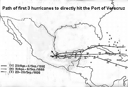
Out of those 41 hurricanes during the last 441 years, only 7 have come
directly into the Port of Veracruz:
The
Port of Veracruz has been right in the path
of only 7 hurricanes:
|
Nr.
|
Name
|
Date
|
|
1
|
Unnamed
|
September 2nd, 1552
|
|
2
|
Unnamed
|
September 8th, 1888
|
|
3
|
Unnamed
|
September 26th, 1926
|
|
4
|
Unnamed
|
September 16th, 1931
|
|
5
|
Unnamed
|
October 3rd, 1932
|
|
6
|
Janet
|
September 29th, 1955
|
|
7
|
Tropical depression
|
June 15th, 1961
|
Interested in hurricanes in the area? find
out more at:
http://www.hurricanecity.com/
El Radar Meteorológico se emplea para la medición
y seguimiento de fenómenos atmosféricos constituidos por
agua,
en forma de lluvia, granizo y nieve principalmente.
La ventaja de un radar meteorológico es equivalente al empleo de
cientos de pluviometros distribuidos a lo largo
de la zona de cobertura del radar, que transmiten la información
en
tiempo real. El radar tiene ademas la posibilidad
de realizar estudios de volumen de la nube, a diferentes cortes o
secciones, así como de dar seguimiento
y estudio de fenómenos severos como huracanes. El Radar meteorológico
es
sin duda una valiosa herramienta con tecnología
de punta con que cuentan los Meteorológos para realizar los
pronósticos del clima.
La Red Nacional de Radares Meteorológicos
esta formada por 12 radares, 7 de estos son nuevos con tecnología
completamente digital marca ERICSSON con la facilidad
de controlarlos remotamente por medio de software que lo
automatiza totalmente, los 5 restantes fueron
adaptados de tecnología analógica a digital marca EEC, todos
están
provistos con el sistema Doppler, lo que permite
conocer la velocidad y la dirección del blanco.
Todas las estaciones de Radar cuentan con un sistema
ininterrumpible de energía, sistema de protección contra
incendios y un sistema de comunicaciones vía
satélite con el centro colector de datos que se encuentra ubicado
en las
instalaciones del Servicio Meteorológico
Nacional en la ciudad de México, en donde se analiza, se procesa
y se
almacena toda la información. La red proporciona
una cobertura aproximada del 70% del Territorio Nacional, las
coordenadas geográficas, su altitud sobre
el nivel del mar así como FOTOS de las Estaciones de Radar.