The Destruction of Barrier Ditch
& South Lines Battery
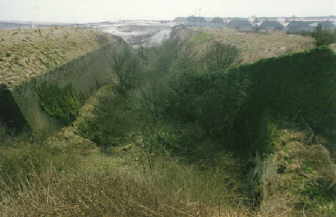
The section of dry ditch running from the south-west end of South-Front Barracks down to the old Folkestone Road is known as the Barrier or South Lines Ditch. It dates from 1806 and when constructed formed a physical barrier against an invading force advancing from the west.
Looking Down Barrier Ditch in 1993. Diggers Still Working on the Horizon
Unfortunately around 60% of it was demolished in 1992 to make way for a new extension to the A20. The construction of the new road was part a larger plan incorporating the building of the channel tunnel, the transformation of the Snargate and Townwall Street areas of Dover seafront and the construction of the Eastry to Whitfield bypass. The total scheme was developed to aid road traffic along its journey through this corner of East Kent and to encourage commerce in the area.
The building of the new A20 didn’t stop at destroying a section of ditch; it also managed to destroy Dover’s only Petroleum Warfare Department (PWD) Flame Barrage Tanks and pump house, situated at the lower end of the ditch. These were installed in 1940 and would have been used to pump an oil/kerosene mixture onto Shakespeare’s Beach which would have been ignited following Hitler’s attempt at Operation Sealion.
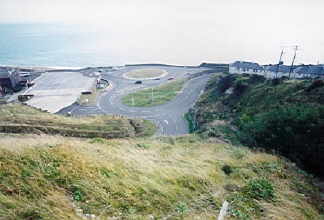
The effects of all the above can be seen today, except of course for the PWD tanks. The Barrier ditch is now in an appalling state, being completely overgrown with scrub and no attempt having been made to tidy up the truncated end. The only blessing is that below the new roundabout the original cliff-end of the ditch can still be seen.
The Route
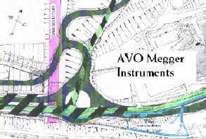
The areas that would be most affected by the proposed route, or Blue Route as it was known in the 1970’s & 80’s ,as far as the loss of military architecture was concerned would be the narrow gap between Archcliffe Fort and AVO – Megger instruments across the road and the building of a new roundabout at the Barrier ditch.
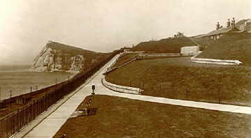
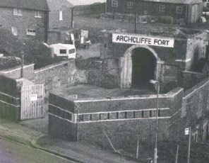
The Front of South Lines Battery Probably in the 1960's and........... About The Same View, 1999
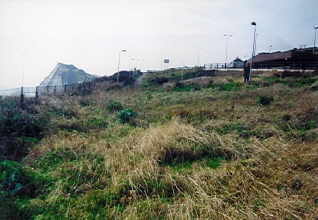
The left picture shows Archcliffe Yard on the right hand side, this has been replaced in the recent picture by AVO-Megger Instruments.
1974 – A New Road
The route of the new or current road was first hit upon in 1974 when the scheme was seen as a way of improving access to the town and port of Dover. At this time Dover District Council was not in favour of this route. However, since members of any Council may change from time to time this was not always going to be the case. When the scheme changed from being considered as beneficial to essential because of the building of the channel tunnel the Council endorsed their support for the plan and stated that….
‘It is the democratically elected local authority for the whole of the area through which the proposed road would pass and is also the local planning authority, and its views properly reflect those of the majority of persons residing in its area.’
In other words, you voted for us, we want the road, therefore you must want it too.
Supporters and Objectors
The Supporters of the new scheme were:
Dover District Council
Kent County Council
Dover Harbour Board
There were 18 official objectors to the proposed route:
National Trust
Countryside Commission
Kent Federation of Amenity Societies
Council for the Protection of Rural England (Kent Branch)
Kent Trust for Nature Conservation
Ramblers’ Association (Kent area)
East Kent Field Centre
Councillor GJ Hood
English Heritage
Sealink (UK) Limited
George Hammond (Shipping) Limited
Gateway Resident’s Association
Dover Incorporated Chamber of Commerce
East Cliff/Athol Terrace Association
Miss PW Thomas
Mr RE Davidson
Mr RJ Frost
Mr PD Stebbings
In 1981 the Council investigated the construction of a tunnel beneath Western Heights to connect the seafront road with the existing road at Farthingloe to the north-west of the Heights, and applied to the EEC for funds to aid construction. When it became apparent that no such funds would be made available the idea was dropped.
Likely Damage
The Landscape Advisory Committee stated in its fifth report that Archcliffe Fort will lose its barbican which is of serious concern but continued to comment upon the current state of the Fort and the apparent lack of interest in it. With regards the new roundabout…
‘is welcomed because this road gives access to the Western Heights and the redevelopment of that area for housing and/or an hotel/conference centre depends upon good access to the A20 route.’
There were 14 alternative routes.
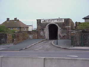
The Georgian Barbican that was partly Demolished to Make way for the New Road.....and Right,
How the Fort looks Today
Taken From 'The History of Archcliffe Fort' by Douglas Welby. Used With Kind Permission From the Author.
The military ditch, the deep brick-faced moat or cutting which runs from Western Heights down to the cliff edge, will be virtually eradicated for about ľ of its length. The Commission therefore strongly objects to the PR and supports the full consideration of any alternative routes, such as A2 and 2C, which avoid damage to the fort and military ditch.
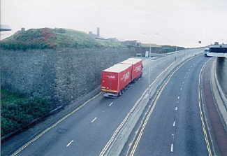
Archcliffe Fort on the Left, the North-East Bastion Lapped by the New Road
The fort is now a St. Emmaus Trust Home consequently an additional entrance has been made by cutting a hole in the curtain wall
How the Road Looks Today Taken From the Truncated End of Barrier Ditch
The PWD Tanks Would Be Roughly To the Left of the First White House